

Choking global trade
Low rainfall and shrinking rivers are causing shipping bottlenecks, and higher prices, around the world.
To get from Minnesota to China, a load of soybeans might meander down the Mississippi River on a barge, transferring around New Orleans to a ship that carries it through the Panama Canal and across the Pacific.
But this summer, low water levels have throttled traffic moving through the canal and limited barge cargo on the river. In Europe, the Rhine and Danube rivers, both important shipping channels, also saw record-low water levels.
Across the logistics industry, it’s been a season of bottlenecks caused by low rainfall and shrinking rivers.
Read more on The New York Times.
Can an entire Arctic ecosystem evolve to adapt to the climate crisis?
In the first project of its kind, scientists are trying to answer if the future of Alaska’s streams and tundra may depend not on survival of the fittest but on how species adapt together
On Alaska’s North Slope, scientists tread carefully across clumps of tussock grasses toward a fast-flowing stream draining the imposing Brooks Range of ice and snow. Near Galbraith Creek, they string out a mist net for white-crowned sparrows. The birds have recently arrived from southerly latitudes, intent on feasting on the insects that will soon descend on the tundra like storm clouds.
The Arctic summer is short-lived, and sparrows have only a few weeks to establish territories, find mates, lay eggs and raise their chicks on a steady diet of bugs. From every ensnared bird, the scientists collect blood, feather and faecal samples to see what they are eating and how that changes over the summer.
Continue reading on The Guardian.
Disappearing lakes and AI are helping scientists map Arctic permafrost thaw in near‑real time
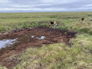
Florida gets a lot of attention for its sinkholes, especially when they swallow cars and entire houses. But its sinkhole risk has nothing on Alaska’s.
Much of Alaska’s soil is permafrost – ground that remains below 32 degrees Fahrenheit (0 degrees Celsius) for at least two consecutive years. It is often rich with ice, but when that ice melts, the ground can collapse. As temperatures rise, that’s happening more often across the Arctic.
The consequences are the same as in Florida: substantial property damage as the land that buildings, roads and pipes were built on sinks.
Continue reading on The Conversation.
A global gathering to tackle the planet’s soil crisis is underway in Mongolia
This year’s Convention to Combat Desertification focuses on rangelands and attempts to address an overlooked solution to climate change.
In Ulaanbaatar, Mongolia, policy makers, scientists and global negotiators are gathering to convey an urgent message: The world’s rangelands, which make up about half of Earth’s land surface, are in trouble. But these same lands offer an opportunity. If, collectively, farmers and land users restore rangelands and soils, they can combat drought and preserve a major global carbon sink.
Unlike the burning of fossil fuels, everyone seems to agree that something needs to be done about them.
Read more on Inside Climate News.
New fire satellites offer hope for Amazon and other biomes, but local barriers remain
Record wildfires devastated South America in 2024, raging out of control in biomes where fire is a natural part of the ecosystem, but also entering rainforests that had never burned before. Driven by expanding industrial agriculture, an El Niño episode, and droughts worsened by global climate change, the thick smoke from the wildfires grounded flights, shuttered schools, and caused lasting health problems.
Climate change speeding up
Current climate change has been well underway for decades, but the rate of that change is now going up so fast that people are noticing things like tornados and extreme heat waves are occurring in places where they have rarely been seen before. Dr. Jennifer Francis, a senior atmospheric scientist at the Woodwell Climate Research Center, joins Host Steve Curwood to explain how greenhouse gases from burning fossil fuels, the loss of reflective ice and snow, and other changes are increasingly causing the Earth to retain extra heat energy from the Sun.
Listen or read more on Living on Earth.
How climate change is influencing Europe’s record-breaking heat wave
NPR’s Michel Martin speaks with Jennifer Francis, senior scientist at the Massachusetts-based Woodwell Climate Research Center, about the impact of Europe’s heat wave and its links to climate change.
A message from President & CEO Dr. Max Holmes
My house was built in 1870. It has been heated by wood, coal, oil, natural gas, and now electricity drawn from the sun. In one sense, that is a mundane property record. In another, it is the entire history of human energy, compressed into a single address.
Wood came first. It always does. Since our ancestors learned to control fire, biomass has been the default answer to cold and darkness. The house would have had a cast-iron stove, fed by wood cut from nearby forests. This is how virtually every human being on earth stayed warm for tens of thousands of years, and many still do. It worked, but it was labor-intensive, land-hungry, and contributed to deforestation.
Coal replaced wood in the industrializing Northeast not because it was loved but because it was dense, cheap, and abundant. A ton of coal contained far more energy than the equivalent volume of wood and could supply cities that had long since stripped their surrounding forests. Then came oil – heating oil delivered by truck, burned in a furnace that could be thermostatically controlled. Oil heat was modern. It was convenient. It was what the house was running on when my wife and I bought it in 2000. The following year, we switched to natural gas, piped directly to the boiler—cleaner than oil, cheaper at the time, and widely regarded as a “transition fuel.” Last year, we made what I believe will be the final transition: heat pumps, powered by electricity, with solar panels on the roof and a contract for renewable energy for anything we draw from the grid.
The sequence—biomass, coal, oil, gas, electricity—is not just our home’s story. It is the arc of modern civilization. And the direction of travel has always been the same: toward fuels that are denser, cleaner, and more controllable, and away from those that are dirtier, heavier, and harder to move. Electricity, especially when generated from wind and sun, is the logical end of that arc. The sun and wind are limitless natural resources and our ability to harness them into electricity will only continue to be more efficient. The energy transition the world is now debating is not some radical rupture; it is the next step in a journey that has been underway since the first furnace replaced the first wood-fired stove.
The only real question is speed. And here, the conflict now consuming the Persian Gulf offers an unexpected answer. The closure of the Strait of Hormuz following the outbreak of military conflict with Iran has removed close to one-fifth of global oil supplies from the market. Prices have reached $100 per barrel or higher. Nations that import the majority of their fuel from the Persian Gulf are facing genuine shortages. The head of the International Energy Agency has called it the greatest global energy security challenge in history.
The conventional assumption might be that an oil shock slows the energy transition – that higher prices make everything more expensive and governments retreat to fossil fuels out of desperation. History suggests the opposite. The 1973 Arab oil embargo helped to launch solar research, energy efficiency standards, and nuclear expansion. Countries around the world are again confronting the danger of energy dependence. That recognition tends to produce investment in alternatives, not capitulation to the status quo.
There are headwinds, of course. The current U.S. administration has been openly hostile to renewable energy, rolling back incentives and attempting to prop up coal and oil production. But administrations are temporary. Solar panels and heat pumps are not. The economics of clean energy have already crossed the threshold at which policy resistance can reverse them; what governments can do now is slow the transition at the margin, not stop it. And a geopolitical crisis that makes the cost of fossil-fuel dependence unmistakable—not in future climate projections but in today’s energy prices—has a way of clarifying minds.
My house has been through this before. It didn’t choose its fuels for ideological reasons; it followed the logic of cost, availability, and technology. The world’s energy system will do the same.
At a time when climate victories are scarce, an acceleration of the energy transition is reason for hope. Those with the financial means—and perhaps the broader good fortune to live in a time and place where the choice is available—can lean into this transition, doing what they can to speed the inevitable shift away from fossil fuels and toward what I believe will be humanity’s ultimate energy source: clean electricity generated from renewable sources.
The energy transition alone will not solve the climate crisis, but it is an essential step in that direction.
Onward.