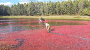
Northeast drought endangers Massachusetts’ cranberry harvest
Another year of erratic weather means cranberry farmers are facing slim margins and tough decisions.
The ancient subarctic forests at risk from climate change and war
The boreal ecosystem that covers swaths of Russia and North America is nearing a dangerous tipping point
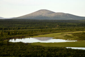
In summer 2019, the Cambridge physicist Gareth Rees flew into Yakutsk to meet a team of Russian scientists. The far eastern Siberian port is known as the coldest city on Earth, but that year it was simmering under a heatwave. Together the researchers drove deep into the region’s sprawling forests on a road paved by gulag prisoners.
The British and Russian scientists were on a mission to study how the boreal forests of the subarctic region are transforming with climate change. Together they measured 2,000 trees, sweating under the heavy clothes protecting them from crowds of insects.
Why Arctic fires are releasing more carbon than ever
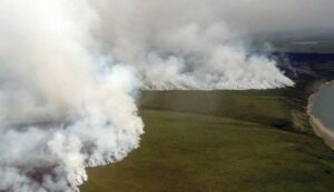
Smoke from hundreds of wildfires darkened skies over the Alaskan Interior this summer, with the state experiencing its fastest start to the fire season on record amid hot and dry conditions.
Tens of thousands of lightning strikes ignited the majority of active fires, according to the Bureau of Land Management Alaska Fire Service. By late August, more than 3 million acres had burned across the state—roughly triple what’s seen in an average year, but no longer unusual in a warming world.
With climate change raising Arctic temperatures faster than the global average, wildfires are shifting poleward where the flames blaze through boreal forest and tundra and release vast amounts of greenhouse gases from the carbon-rich organic soil.
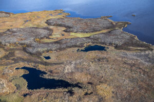
The Alaskan wilderness reveals the past and the future
The oil flows more slowly, the climate changes more quickly
Explainer: Pakistan fatal flooding has hallmarks of warming
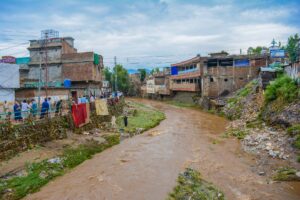
The familiar ingredients of a warming world were in place: searing temperatures, hotter air holding more moisture, extreme weather getting wilder, melting glaciers, people living in harm’s way, and poverty. They combined in vulnerable Pakistan to create unrelenting rain and deadly flooding.
The flooding has all the hallmarks of a catastrophe juiced by climate change, but it is too early to formally assign blame to global warming, several scientists tell The Associated Press. It occurred in a country that did little to cause the warming, but keeps getting hit, just like the relentless rain.
Continue reading on Associated Press News.
Record rain is hitting drought-stricken areas. That’s not good news.
A warmer climate is driving precipitation to higher extremes in both flooding and drought

Extreme ‘whiplash’ between drought and floods makes it harder to recover from climate disasters
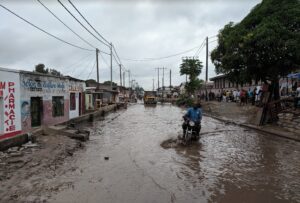
Parts of northern Texas, mired in a drought labeled as extreme and exceptional, are flooding under torrential rain. In a drought.
Sound familiar? It should. The Dallas region is just the latest drought-suffering-but-flooded locale during a summer of extreme weather whiplash, likely goosed by human-caused climate change, scientists say. Parts of the world are lurching from drought to deluge.
