Canada’s wildfire season is off to an ‘unprecedented’ start. Here’s what it could mean for the US
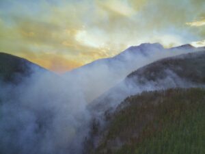
Raging wildfires in Canada have already scorched about 15 times the normal burned area for this time of the year: nearly 11 million acres — more than double the size of New Jersey — with more than 2 million acres concentrated in Quebec alone.
Canada’s fire season is only just beginning, and officials there warned this week it would continue to be severe through the summer. If it follows the pattern of a normal year, it will peak in the hotter months of July and August.
But this is anything but a normal year.
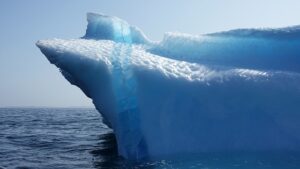
How Arctic ice melt raises the risk of far-away wildfires
The thawing of the polar region from climate change helps produce conditions that make distant forests more likely to burn.
As millions of people in New York and other major North American cities choke on acrid smoke, they could point their accusatory fingers farther North than the wildfires ravaging Quebec — all the way to the global Arctic.
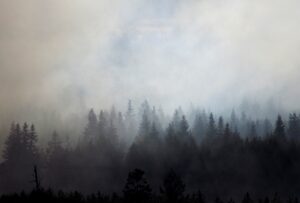
Canada’s fire season has barely started and it’s already on track to break records. So far, NOAA has documented more than 2,000 wildfires that have resulted in the forced evacuation of over 100,000 people across Canada. The most recent bout of fires burning in Ontario and Quebec has sent smoke southward into the Eastern U.S., causing record levels of air pollution in New York and warnings against outside activity as far south as Virginia.
Only a little over a month into the wildfire season, fires have already burned 13 times more land area than the 110-year average for this time of year, and they show no sign of stopping, according to Canadian publication The Star. Indigenous communities, some of whom live year-round in remote bush cabins, have been particularly harmed by the blazes.
According to Woodwell Climate Senior Scientist Dr. Jennifer Francis, the phenomenon of winds pushing smoke down to the northeastern U.S. has been linked to rapid Arctic warming caused by climate change.
In the upper atmosphere, a fast wind current called the jet stream flows from west to east in undulating waves, caused by the interaction of air masses with different temperatures and pressures, particularly between the Arctic and temperate latitudes.
As global temperatures have risen, the Arctic has warmed two to four times faster than the average global rate. Dr. Francis stated in an interview in the Boston Globe that the lessening of the temperature differences between the middle latitudes and the Arctic has slowed down the jet stream, which results in a more frequent occurrence of a wavy path.
Another factor contributing to the widespread smoke is an ongoing oceanic heat wave in the North Pacific Ocean. The blob of much-above-normal sea water tends to create a northward bulge in the jet stream, which creates a pattern that sends cooler air down to California and warm air northward into central Canada—resulting in the persistent heat wave there in recent weeks. Farther east, the jet stream then bends southward and brings the wildfire smoke down to the Northeast.
“Big waves in the jet stream tend to hang around a long time, and so the weather that they create is going to be very persistent,” Dr. Francis said. “If you are in the part of the wave in the jet stream that creates heat and drought, then you can expect it to last a long time and raise the risk of wildfire.”
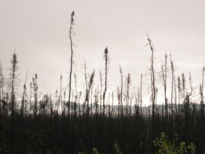
The wildfires are also decimating North American and Canadian boreal forests, the latter of which holds 12 percent of the “world’s land-based carbon reserves,” according to the Audubon Society<./a> And three quarters of Canada’s woodlands and forests are in the boreal zone according to the Canadian government.
“The surface vegetation and the soil can dry out pretty dramatically given the right weather conditions. For this fuel, as we call it in fire science, it often just takes one single ignition source to generate a large wildfire,” said Woodwell Climate Associate Scientist Dr. Brendan Rogers.
As the climate continues to warm, Dr. Rogers said the weather conditions that lead to fuel drying and out-of-control wildfires also increase. This creates a feedback loop. Heat waves caused by greenhouse gas emissions increase the prevalence of wildfires. The fires in turn destroy these natural carbon sinks and, in turn, speed up climate change.
While the ultimate solution to breaking this feedback loop lies in reducing emissions and curbing climate change, Dr. Rogers and other researchers at Woodwell Climate have conducted research into fire suppression strategies that could help prevent large boreal fires from spreading and help keep carbon in the ground.
A study conducted in collaboration with Woodwell and other institutions found that suppressing fires early may be a cost-effective way to carbon mitigation. Woodwell Climate’s efforts also include mapping fires, using geospatial data and models to estimate carbon emissions across large scales, and looking at the interplay between fires and logging.
“Reducing boreal forest fires to near-historic levels and keeping carbon in the ground will require substantial investments. Nevertheless, these funds pale in comparison to the costs countries will face to cope with the growing health consequences exacerbated by worsening air quality and more frequent and intense climate impacts expected if emissions continue to rise unabated. Increased resources, flexibility, and carbon-focused fire management can also ensure wildlife, tourism, jobs, and many other facets of our society can persevere in a warming world,” Dr. Rogers said.
Record pollution and heat herald a season of climate extremes
Scientists have long warned that global warming will increase the chance of severe wildfires like those burning across Canada and heat waves like the one smothering Puerto Rico.
It’s not officially summer yet in the Northern Hemisphere. But the extremes are already here.
Fires are burning across the breadth of Canada, blanketing parts of the eastern United States with choking, orange-gray smoke. Puerto Rico is under a severe heat alert as other parts of the world have been recently. Earth’s oceans have heated up at an alarming rate.
Human-caused climate change is a force behind extremes like these. Though there is no specific research yet attributing this week’s events to global warming, the science is unequivocal that global warming significantly increases the chances of severe wildfires and heat waves like the ones affecting major parts of North America today.
Continue reading on New York Times.
The wildfires in Canada are abnormally early and widespread this year. What’s at play?
In recent years, the word “wildfire” has conjured heartbreaking images that became grimly predictable: California ablaze, from its mighty forests to gracious vineyards and traffic-clogged highways of fleeing people.
It’s different this year, as the East Coast chokes on smoke blown south from abnormally early and widespread wildfires in Canada. Pennsylvania and New Jersey are now facing critical risks of fire danger, and more broadly the Northeast and Midwest also face elevated risks of wildfires, while California is at lower risk thanks to a record-high snow pack from this past winter.
What’s at play, climate scientists said, is an atmosphere increasingly roiled by conditions that can unpredictably shift areas of drought to deluge, as has happened in California, only to sow drought and excessive heat in another.
Continue reading on The Boston Globe.
On April 20, 2023, the U.S. Department of the Interior (DOI) and Department of Agriculture (USDA) released a first-of-its-kind inventory of the country’s mature and old-growth forests. The assessment responded directly to a 2022 executive order aimed at fostering healthy forests.
The inventory highlights the importance of forest health in building resilience to future climate-related disturbances like drought or fire, but it omits mention of the service that all forests, but particularly mature and old growth forests, provide in directly mitigating the country’s carbon emissions—a service that Woodwell Climate’s scientists have worked to measure and monitor for over three decades.
The inventory is a critical starting point, from which agencies like the U.S. Forest Service and the Bureau of Land Management will begin to make decisions about how public forests are managed going forward. Not acknowledging the critical carbon storage contribution of mature and old-growth forests runs the risk of de-prioritizing protection for the country’s oldest, most carbon-rich, and hardest to replace ecosystems.
Why protect mature and old-growth forests?
In short: carbon. While all forests sequester carbon as they grow, older and larger trees represent an existing store of carbon in their biomass and soil. Research by Woodwell Climate scientists on carbon stocks in a sample of federally managed U.S. forests found that while larger trees in mature stands constitute a small fraction of all trees, they store between 41 and 84 percent of the total carbon stock of all trees.
An analysis of mature and old growth forests across the country found that approximately 76 percent (20.8 million hectares) of these forests are unprotected from logging. This represents an amount of carbon roughly equivalent to 1 quarter of the US’s annual fossil fuel emissions.
Although younger forests grow faster proportionally, they are not adding as much carbon in a single year as older forests with large trees. Additionally, mature forests continue to pack away carbon year over year in their soils, which is largely protected from effects of disturbance. Cutting down a mature forest creates a “carbon debt” that can take decades—centuries in some cases—to recoup, and in the meantime those mature trees are no longer sequestering carbon each year.
“Forests are like naturally occurring factories, delivering to the planet the unique service of carbon sequestration. Trees of all sizes, but particularly large old trees, are the equivalent of warehouses where the goods produced—tons of carbon—are stored over time,” says Woodwell Climate Carbon Program Director, Dr. Wayne Walker. “Like any warehouse where valuable goods are stored, these natural carbon reserves deserve all the protection we can provide. Their loss could effectively bankrupt our efforts to avoid the worst impacts of climate change.”
Defining mature and old-growth forest
Protecting mature forests requires them to be identified and mapped, which was part of the impetus behind the government’s forest inventory. But what actually is a mature forest?
Definitions of “mature” and “old-growth” differ, with no one universally accepted definition. Refining scientific understanding of what constitutes a mature forest has implications for either expanding or reducing the area of forest considered for protection.
In one study of U.S. forest carbon stocks, Woodwell Climate researchers and collaborators outlined a measure of forest maturity based on both the age that the tree canopy in a forest becomes 100 percent closed, called “Culmination of Net Primary Productivity,” and tree diameter size. Across 11 U.S. forests analyzed, the age at which a forest is considered mature ranged from 35 years in Appalachian forests to 75 in Arizona. “Old-growth” represents a smaller subset of mature forests having older and larger trees.
The new inventory from the DOI and USDA uses a slightly narrower definition of maturity, wherein the lower bound occurs when regeneration has begun underneath the canopy. This results in a slightly smaller estimation of the amount of mature and old-growth forests in the US—yet still approximately 63 percent of the total area of federally managed forests.
Other definitions can be based on models that take into account measurements of forest structure like canopy height, canopy cover, and biomass. Another study, co-authored by Woodwell Climate Assistant Scientist, Dr. Brendan Rogers, used these features to determine that federal lands contain the largest concentration of the country’s mature and old growth forests.
Differences in those definitions are important, because forest policy debates surrounding the responsible management of these forests depend on adequately identifying them, particularly mature forests, which are much more loosely defined than old-growth.
“I think the discussion is almost more about what to do with mature forests, as opposed to old-growth,” says Woodwell Climate senior scientist, Dr. Richard Birdsey, who worked in the U.S. Forest Service for four decades. “Mature forests are at a younger stage of growth—trees would be smaller, although they could still be substantial in size and very profitable to harvest. So the question here is whether to let those forests grow into old-growth characteristics, or to start harvesting them for wood products.”
What do we do with our mature forests?
When climate benefits are explicitly considered, the research points strongly to letting these forests grow—protecting and expanding the massive portion of sequestered carbon they represent.
According to Dr. Birdsey, the largest threat facing mature and old-growth forests in the U.S. is logging, which is a threat that humans can reduce instantly, simply by changing policy. A change that would make those forests more resilient to other threats in the long run.
“Others might argue that climate change or wildfire are more significant threats,” says Dr. Birdsey. “Older forests with larger trees are more resistant to those threats—but not more resistant to chainsaws. That’s a human decision.”
A recent paper in Nature Climate Change has laid out a “protect, manage, restore” framework for making decisions about what natural climate solutions to pursue, and the highest priority is always to protect carbon where it is already stored. U.S. policies have made some recent progress in this direction through the enforcement of the roadless rule on Alaska’s Tongass National Forest, prohibiting road-building and industrial logging on the 9 million acre temperate rainforest. But there is still further to go to capitalize on the carbon storage potential of the U.S.’s mature forests.
Federally managed forests contain more high-carbon trees than other lands, so the opportunity for increased carbon storage within them is greatest. Woodwell Climate Distinguished Visiting Scientist, Dr. William Moomaw, helped coin the term “proforestation” to refer to the strategy of letting forests continue to grow as a carbon solution. In order to achieve that, he says, mature forests have to be protected.
“The next steps should be to provide legal protection of as much of these high-carbon forests as possible,” says Dr. Moomaw. “These are public lands that should serve the public good, and reducing climate change is a public good that we should pursue as the highest priority.”
