Trees are overrated
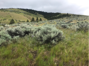
Preserving the world’s great expanses of grass could be essential to combatting climate change.
A Maine forest offers decades of data on the ability of trees to remove carbon from the air

For decades, scientists from around the world have been visiting a mature forest just off the interstate, about 30 miles north of Bangor.
They’ve undertaken groundbreaking studies on acid rain, forest ecology and soil health. NASA used it for a remote sensing project. And at one point the 550-acre Howland Research Forest was the most photographed place on the planet — from space.
Continue reading on Maine Public Radio.
Record-breaking heat waves in US and Europe prove climate change is already here, experts say
Concurrent heat waves across the globe will continue to shatter records.

Hundreds of millions of people around the world are currently experiencing sweltering, dangerous heat — a new reality as the effects of climate change continue to manifest in severe weather events of every kind.
A scorching airmass remains over the majority of the continental U.S. on Wednesday, with a heat dome sitting over the Southwest and Great Plains and triple-digit temperatures stretching throughout the Midwest and up and down the East Coast.
We need to talk about permafrost and its impact on the climate
On The Carbon Copy podcast this week:
In the Global North, up to 15% of the earth’s surface is covered in permafrost. Permafrost is a frozen layer of rocks, soil, ice and partially decomposed plants — and it’s a massive carbon sink.
The earth’s permafrost layer contains 1.5 trillion metric tons of carbon. That’s twice the amount currently in the earth’s atmosphere. And, no surprise, it is melting at an accelerated rate due to climate change.
Read more and listen on The Carbon Copy.
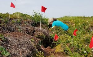
It’s a windy morning in May and the Valdez ranch in Delta County, Colorado is alive with the sounds of lowing cattle, chattering sparrows, and the whirrs and clanks of scientific equipment. This particular field is not being grazed at the moment, so Woodwell’s soil carbon team has free rein over the rows of alfalfa and sweetgrass.
In collaboration with Dr. Megan Machmuller at Colorado State University, Assistant scientist Dr. Jennifer Watts and senior scientist Dr. Jon Sanderman have brought their teams here to collect field observations that will help inform a comprehensive model of carbon storage on rangelands across the United States. Grazing lands have the potential to be a valuable carbon sink, provided the livestock on them are being sustainably managed, but the true magnitude of that value is not yet well understood. Developing a regional model of the way carbon moves through rangelands will deepen our understanding of the role they play as a natural climate solution.
Ensuring the model’s accuracy requires the team to collect an array of field data from different ranch types—from irrigated and planted pasture, to the natural vegetation of high mountain and desert grazing lands. Here’s how climate scientists study carbon in the field:
Carbon flux: What’s moving in and out of the atmosphere?
Soil carbon storage begins where plants interact with the air. As they grow, plants draw carbon out of the atmosphere through photosynthesis. When they decay, microbes in the soil digest plant matter and breathe carbon dioxide and methane back out. Measuring the difference between these two processes gives us “net ecosystem flux”—a measure of whether a patch of land is sequestering or emitting carbon overall.
Measuring carbon flux requires a specially made chamber. Dr. Watts and Seasonal Field Technician Jonas Noomah employed a plexiglass contraption that Noomah constructed himself. The chamber is placed over a patch of ground, connected by clear tubes to a machine that can analyze the volume of CO2 within the cube. A handheld fan dangles inside the box to keep the air circulating. The transparent plexiglass allows photosynthesis to continue unhindered. After a few minutes, the box is covered to block out the light and the analysis is run again to capture emissions without the photosynthesis component. The numbers can be compared to assess the rate and overall carbon sink or source status of flux within the ecosystem.
Plant productivity: What’s growing under-hoof?
While plants are growing, they lock away carbon as part of their leaves, stems, and roots, so another important metric in the carbon model is plant productivity—more productive plants with established root systems are more likely to store more carbon belowground.
Productivity can be estimated with satellite imagery, but needs to be validated with on-the-ground measurements. Postdoctoral researcher Dr. Yushu Xia and research assistant Haydée Hernández-Yañez walked transects of pasture to collect data on a variety of indicators that could influence aboveground (and belowground) biomass, including height of vegetation, soil moisture, and temperature. Then the scissors come out and all the plants in a plot are cut and put into a labeled paper bag to be weighed and analyzed later in a lab to determine the total mass of plant matter.
Rangelands managed for better carbon storage also come with a host of co-benefits, including higher levels of plant diversity. Different plants cycle carbon and other nutrients at different rates, so Hernández-Yañez sifts through the vegetation before it’s snipped, identifying and recording the species to provide more detail in productivity estimates.
Soil carbon: What’s locked deep in the ground?
Over time, carbon passes out of the cycle of growth and decay, becoming locked underground as soil organic carbon. Accessing and analyzing soil organic carbon requires coring deep into the earth and pulling out a stratified cylinder of dirt. Dr. Machmuller led the team’s soil coring effort along with Dr. Sanderman and research assistant Colleen Smith.
With a hydraulic soil coring machine attached to the back of a pickup truck, the team rambled through muddy pasture and over sharp bushes to collect 50 centimeter cores. When the terrain was too steep, they pulled out a handheld corer that had to be driven into the soil with a sledgehammer.
The soil cores are separated into three sections and crumbled up. Smith then uses a handheld scanner that employs the same technology used by astronomers to determine the chemical makeup of distant star systems to read the carbon content of each section. The scanner bounces light off the soil particles and the pattern of reflection gives clues to what molecules are present at different depths. Abundance of carbon is sometimes obvious to the naked eye in the cores, showing up as darker, wet sticky soil.
Putting data in the hands of land managers
Drs. Watts and Sanderman and their team are in the process of creating a rangeland carbon management tool that will make the soil carbon data model accessible directly to ranch managers. The website, developed by Dr. Xia, will generate data on carbon and plant productivity, for any geographic area down to the size of a single pasture. The hope is that the tool could be integrated into land managers long-term decision making, and show the results of adapting to more holistic, sustainable management practices over time.
“In the western US on our rangelands, just like in our croplands, we can change how we manage in a way that potentially could become a natural climate solution,” says Dr. Watts. “One where we’re bringing in more carbon than we’re emitting and we’re creating ecosystems that not only are beneficial for carbon sequestration, but also have more biodiversity, offer more habitat for wildlife, and more water conservation.”
Demonstrating the co-benefits of managing rangelands for carbon will also help expand conversations about whether ranching can be done sustainably, from the ground up.
“It allows for transfer of climate solutions into the hands of practitioners who may not otherwise think about climate change. It opens the conversation.” says Dr. Watts.
Ultimately, having that data could be useful for rangeland managers taking part in carbon credit markets, which could help them get paid for sustainable management.
“Rangelands haven’t been included in voluntary carbon credit markets like cropping systems have,” says Dr. Sanderman. “Their monitoring is a big problem because there’s so much land. How do you keep track of all that? That’s what our tool will be able to offer.”
Deforestation in Brazil’s Amazon hits record for first half of 2022
Deforestation in Brazil’s Amazon rainforest reached a record high for the first six months of the year, as an area five times the size of New York City was destroyed, preliminary government data showed on Friday.
From January to June, 3,988 square km (1,540 square miles) were cleared in the region, according to national space research agency Inpe.
That’s an increase of 10.6% from the same months last year and the highest level for that period since the agency began compiling its current DETER-B data series in mid-2015.
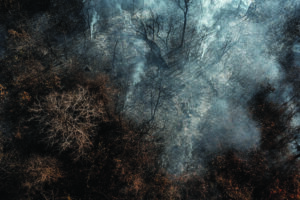
Heat and fires scorch northern Canada
In July 2022, a combination of lightning, dry weather, and unusual heat fueled hundreds of wildland fires in northern Canada. According to the Canadian government, 136 fires were burning in The Yukon and 65 in the Northwest Territories on July 6.
Read more on NASA’s Earth Observatory.
The Amazon rainforest is one of the planet’s best natural climate solutions. Roughly 123 billion tons of carbon are estimated to be stored in the trees and soils of the Amazon and, if protected, it has the power to continue sequestering billions of tons of carbon each year.
But that irreplaceable carbon sink is under steady threat from a cycle of deforestation, fire, and drought that is both exacerbated by and contributing to climate change. Preliminary analysis from Woodwell of last year’s data has outlined that the most vulnerable regions of the Amazon are where drought and deforestation overlap.
2021 data shows deforestation drives fire in the Amazon
Unlike temperate or boreal forest ecosystems—or even neighboring biomes in Brazil— fires in the Amazon are almost entirely human caused. Fire is an intrinsic part of the deforestation process, usually set to clear the forest for use as pasture or cropland. Because of this, data on deforestation can provide a good indicator of where ignitions are likely to happen. Drought fans those flames, producing the right conditions for more intense fires that last longer and spread farther. Examining the intersection between drought and deforestation in 2021, Woodwell identified areas of the Amazon most vulnerable to burning.
Areas of deforestation combined with exceptionally dry weather to create high fire risk in northwestern Mato Grosso, eastern Acre, and Rondonia. Although drought conditions shifted across the region throughout the course of the year, deforestation caused fuel to accumulate along the boundaries of protected and agricultural land.
These areas of concentrated fuel showed the most overlap with fires in 2021, indicating that without the ignition source that deforestation provides, fires would be unable to occur, even during times of drought.
In June of 2021, we identified a dangerous and flammable combination of cut, unburned wood and high drought in the municipality of Lábrea, that put it at extreme risk of burning. Data at the end of December of 2021 confirmed this prediction. The observed fire count numbers from NASA showed that last year, Lábrea experienced its worst fire season since 2012.
Fires and climate change form a dangerous feedback loop
As a result of deforestation in 2021, at least 75 million tons of carbon were committed to being released from the Amazon. When that cut forest is also burned, most of the carbon enters the atmosphere in a matter of days or weeks, rather than the longer release that comes from decay.
This fuels warming, which feeds back into the cycle of fire by creating hotter, drier, conditions in a forest accustomed to moisture. Drought conditions weaken unburned forests, especially around the edges of deforestation, which makes them more susceptible to burning and releasing even more carbon to the atmosphere to further fuel warming.
Fire prevention strategies enacted by the current administration over the past 3 years have been insufficient to curb burning in the Amazon, because the underlying cause of deforestation remains unaddressed. Firefighting crews are not sufficiently supported to continue their work in regions like Lábrea that are actively hostile to combating deforestation and fire. If deforestation has occurred, fire will follow. To ensure the safety of both the people and the forests in these high-risk municipalities, the root causes of deforestation must be addressed with stronger and more strategic policies and enforcement.