photo by Dave Hollinger
Methane is produced by microbes where soils are wet and oxygen is limited, and consumed where soils are dry and well-drained. Within a soil profile, both of these conditions can exist simultaneously, and the net methane emission (source) or uptake (sink) within an ecosystem is determined by the balance between these two processes.
Long-term research has primarily focused on landscapes that produce methane (i.e. wetlands), resulting in sampling bias and a lack of understanding of how methane fluxes differ from wetlands to drier uplands. The potential of upland soils and aboveground biomass to emit or take up methane remains severely understudied. Notably, boreal and sub-boreal forests are the world’s largest land-based biome, and yet the contributions of these forests to global methane dynamics are largely unknown.
The Howland Research Forest in Maine (45°12′N 68°44′W) is located at the southern edge of the boreal ecotone, making it particularly vulnerable to changes in climate—and an ideal location for examining how methane budgets may respond under future climate conditions. Not only is this region warming, but it is also becoming wetter.
An eddy covariance flux tower has been measuring the net exchange of methane between the forest and atmosphere since 2012. This tower has shown that Howland’s landscape is currently serving as net methane sink, and it is unclear under what conditions the forest (and other sub-boreal and boreal forests) might transition from net sink to source.
There is an urgency to understand how these changes are currently happening, so we can best prepare for the future.
Eddy covariance flux towers
Eddy covariance (EC) towers measure the net exchange of greenhouse gasses (like carbon dioxide and methane), energy, and water between ecosystems and the atmosphere, and can determine if these areas are a source (release) or sink (uptake) of a particular greenhouse gas. To measure this exchange, instrumentation is mounted on towers situated above the ecosystem canopy.
In places like the Arctic tundra, where vegetation is low, towers can be relatively short (like the one depicted below) and instrumentation accessible from the ground. However, in a forest (e.g. tropical and boreal forests), towers can measure meters in height and are accessible either as a walk up tower (as in this page’s header image) or as a climbing tower (not shown).
The diagram below shows the instrumentation common to any eddy covariance flux tower.
 graphic by Julianne Waite
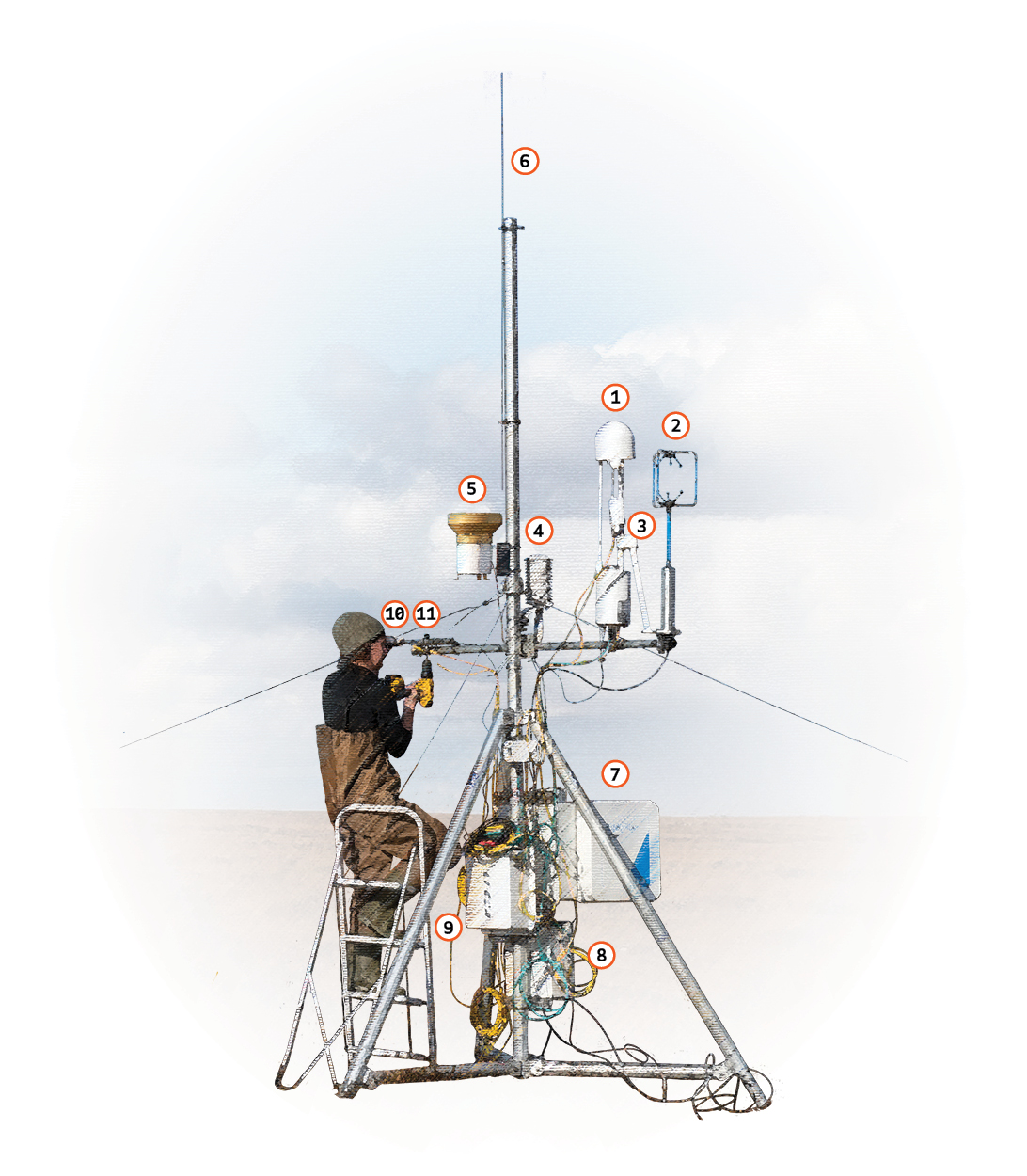
Parts of an eddy flux tower
- Methane analyzer: measures the density of methane in the air
- Sonic anemometer: measures wind direction and speed in three dimensions, used to determine fluxes of methane and carbon dioxide
- Carbon dioxide analyzer: uses infrared technology to measure carbon dioxide and water vapor density in the air (attached to the angled arm)
- Radiation shield: houses air temperature and relative humidity probes, with a shield that protects the probe from precipitation or direct sunlight that would impact the measurements
- Precipitation gauge: measures the amount of rain and snow
- Lightning rod: discharges any lightning strikes that hit the highest point of the tower and prevents electrical surges or damage to tower equipment
- Processing center: the main “brain” of the flux tower that reads data from other instruments, processes them, and centralizes the output
- Additional processing: houses the “brain” of additional environmental measurements like soil temperature and soil moisture, from probes buried in the ground at various depths
- Pump and washer fluid: used to keep parts of the methane analyzer (#1) clean
- Net radiometer: measures incoming and outgoing radiation
- Photosynthetically active radiation (PAR) sensor: measures the amount of plant-usable light for photosynthesis
