Risk team delivers climate risk analyses to under-resourced communities
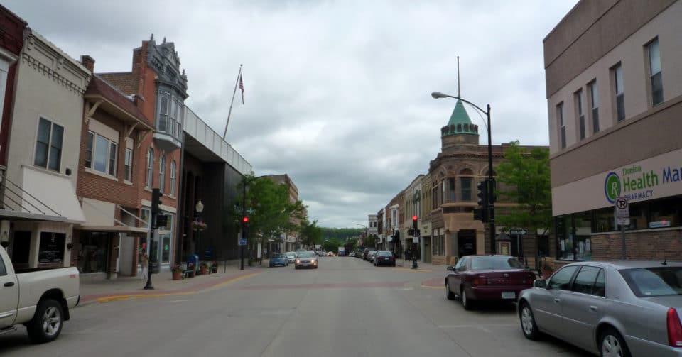

Decorah, Iowa is nestled in a steep river valley, and is prone to flooding despite a robust dike system that was built in the mid 20th century. In the past two decades, the Decorah community has been impacted by two extreme flooding events, both of which caused significant damage to residential areas, parts of the downtown, and Luther College. Cars, homes, and businesses were submerged in murky swamp water, causing many residents and local government officials to reflect on current approaches to environmental hazards and look towards long-term solutions. At the start of 2020, Woodwell Climate partnered with Decorah to help the municipality develop sustainability-oriented approaches to managing flood risk, kicking off a series of climate risk analyses intended to provide decision makers in vulnerable municipalities with actionable information about their climate risk profiles.
Close collaboration with the Decorah Center for Sustainable Communities helped Risk team member Dominick Dusseau create comprehensive flood models that incorporated extreme precipitation, stream flow, and storm surge. “Often, local stakeholders are aware that flooding could pose problems in the future but lack the resources to really examine the full extent of potential damage. With this project, we are able to combine technical expertise with local knowledge and create a complete climate risk profile,” said Dusseau.
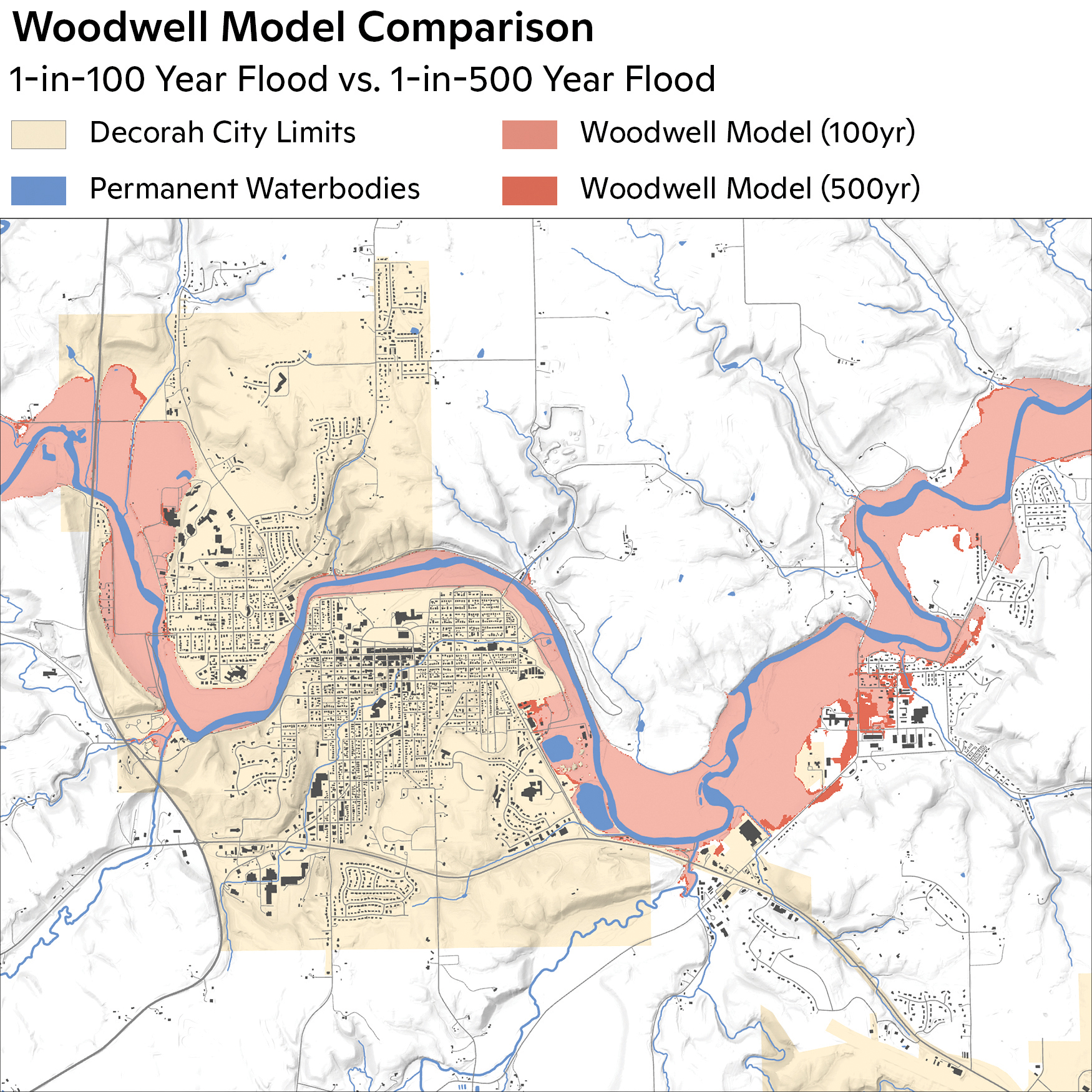
Above: Projected flood risk for Decorah, Iowa.
map by Carl Churchill
Jim Martin-Schramm, Director of Luther’s Center for Sustainable Communities and Chair of the Decorah Sustainability Commission, worked closely with Dusseau to obtain information about dike strength, zoning ordinances, and elevation levels. Access to this data helped Dusseau update old Federal Emergency Management Agency (FEMA) maps to improve low resolution or outdated areas and account for extreme precipitation due to climate change. Flood prone areas across Decorah were pinpointed, including high traffic points such as the centrally located bridge that spans the Upper Iowa River as well as a low-lying vital electric substation on the eastern side of the town.
Most importantly, Woodwell Climate identified a potential commercial development plot as a high flood risk and recommended against building a superstore on this floodplain. This decision was not universally popular, as many felt that it inhibited the town’s economic growth. However, as these decisions become increasingly more difficult in the coming decades due to climate change, accurate assessments of climate risk can protect the municipalities from long-term infrastructure damage and expansion of the floodplains.
“The report provided city council members with the information needed to make difficult decisions about zoning laws,” stated Martin-Schramm. “Woodwell’s expertise will help us better prepare for the challenges climate change will pose.”
Two other reports issued as a part of Woodwell’s pilot program in municipal risk also focused on flooding, as multiple city planners identified it as one of the most relevant extreme weather challenges. By isolating this variable, Woodwell Climate was able to establish protocols for collaboration that will prove useful in future reports. The Center plans to engage with local government officials to determine what models would be most relevant for their planning needs. Currently, Woodwell Climate is working with government officials in Homer, Alaska to decide what hazards and disaster scenarios are most relevant to the city. Common risks like drought, wildfire, flooding, extreme wind, and landslides are being considered alongside local issues, such as declining river health and the impact on salmon populations.
“Many scientists have been struggling to connect their work in the ivory tower to the experiences of individual people,” explains Dr. Bretwood Higman, a scientist and environmental non-profit founder based in Seldovia, Alaska—across the river from Homer. “I think this project is a really interesting example on how to do that right. People at Woodwell are getting in early and talking to local communities to give them real influence over the course of the work.”
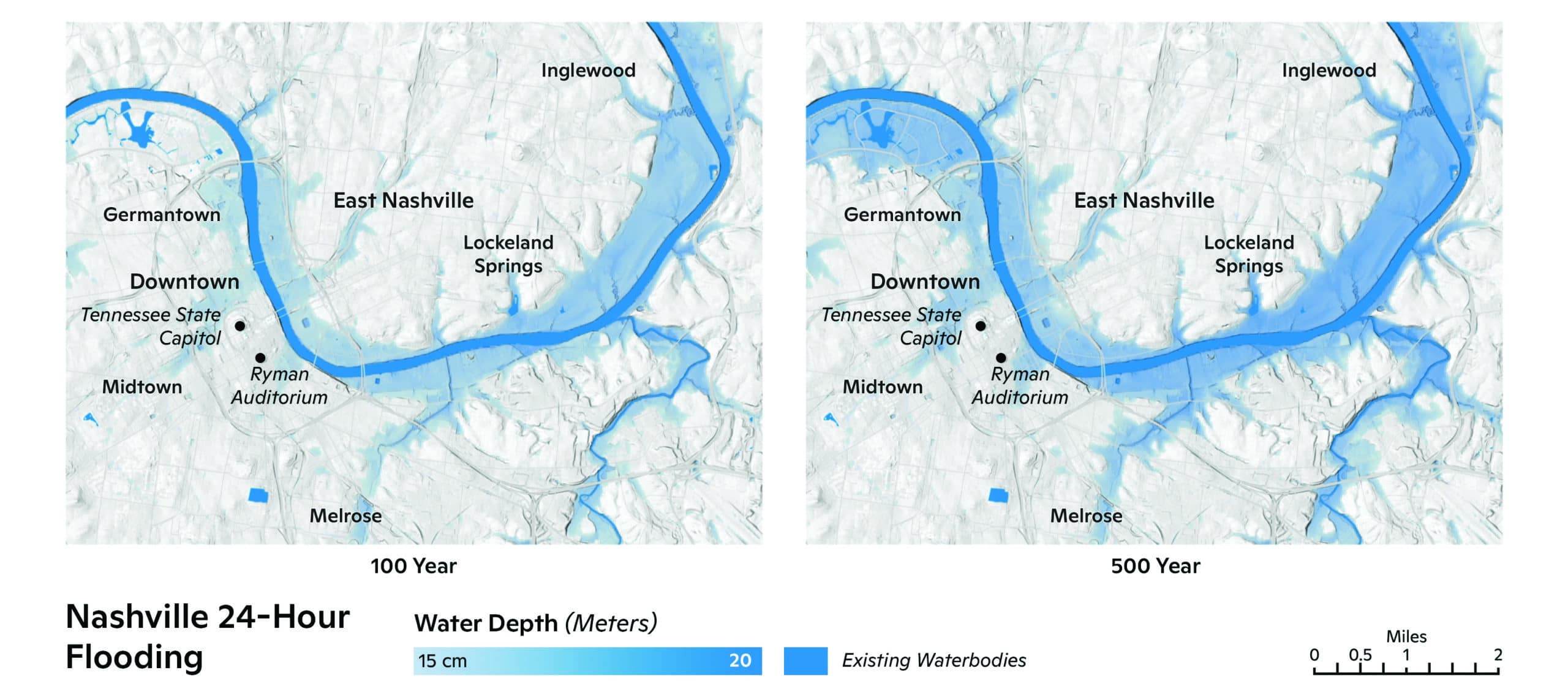
Projected inundation of Nashville, TN resulting from 100- and 500-year storms.
maps by Carl Churchill
Many municipal partnerships have been made possible through collaboration with ICLEI—Local Governments for Sustainability, a leader in local government technical assistance. ICLEI connects the Center with under-resourced cities and towns with long-term sustainability goals. With ICLEI’s support, Woodwell Climate is able to help partner municipalities incorporate research findings into policy going forward. In the coming years, Woodwell Climate will be working with a cohort of cities, both domestically and internationally, to provide assessments of various physical climate hazards. While the Center will continue to model flood risk, Woodwell plans to increase the scope of future projects to deliver a more complete climate risk analysis, including examination of extreme heat, drought, and sea-level rise risk. Such comprehensive reports are particularly important for communities experiencing economic hardship, regional strife, and mass changes in population distribution, as decision makers may not otherwise have the resources to study the infrastructural and social impacts of near-term extreme weather events.
“We believe science is a public good,” shared Chief of External Affairs Dave McGlinchey. “Right now, everyone else who is doing this kind of work is selling it for quite a lot of money. We don’t believe that’s fair. Decision makers need to understand how climate change will impact their community, and we want to make this information as widely available as possible.”
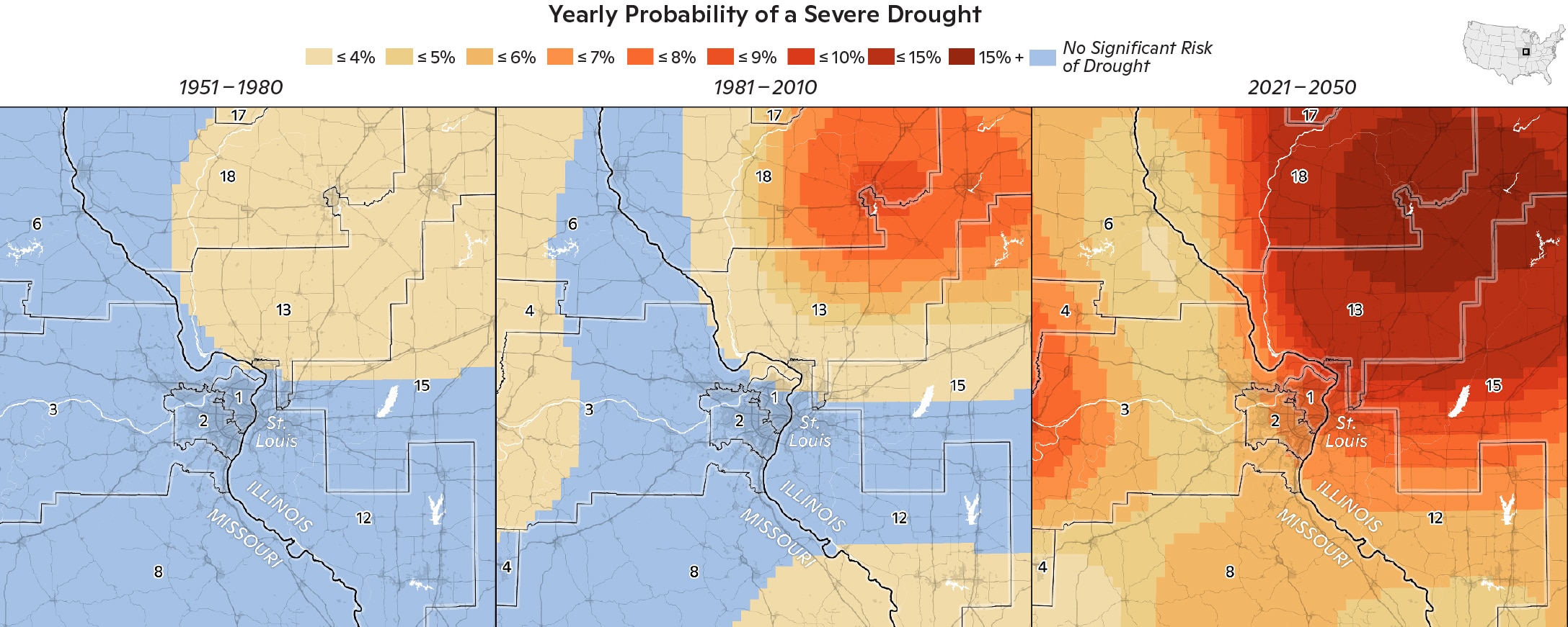
Above: Annual likelihood of extreme drought in the past, present and projected future for the St. Louis, Missouri region.
maps by Carl Churchill
Sustained engagement is critical to the success of these projects, as scientists collaborate with local decision makers from research initiation through policy implementation stages. Over the next three years, the Risk team will pursue between 24 and 36 partnerships with cities and municipalities across the United States and Global South, utilizing connections established by Woodwell scientists living and working abroad and ongoing support from ICLEI. For example, in conjunction with the Fletcher School at Tufts University, Woodwell Climate will provide Addis Ababa, the capital of Ethiopia, with a full flagship report. Already, the Center is preparing to work with six different communities in Brazil.
“I couldn’t be more excited. Much of our work is conducted with the end goal of making the world a better place, but sometimes, the impact is several steps removed from the research we are doing,” said Risk Program Director Dr. Christopher Schwalm. “Now, we have an opportunity to make a direct impact. Quality of life will improve, communities will become more climate resilient, and these cities will be better off in the next 15–20 years.”