September 2025— On the shores of Lago Caracaranã, deep in the Brazilian State of Roraima, a group of Indigenous brigadistas gather around printed paper maps. They have come to this lakeside meeting place from their territories across the state and beyond to learn about maps from Dr. Ray Pinheiro Alves, a research analyst at the Amazon Environmental Research Institute (IPAM). Alves directs each woman to a map of their own territory, completely unlabeled. He hands them drawing supplies, and within moments the brigadistas have oriented perfectly to the map, tracing familiar rivers, home sites, and landmarks from memory.
Roraima is Brazil’s northernmost state. It straddles the equator, and contains both native sweeping grasslands like those around Caracaranã and misty, mountainous stretches of the Amazon rainforest. It is remote, and sometimes disconnected from the rest of the country, yet experiencing the same encroachment from agriculture and illegal mining, and the same increase in destructive fires that often follow in the wake of deforestation. Which is why the Indigenous fire-fighting brigades here are eager to pick up new tools that could help them manage and protect their forests and homes.
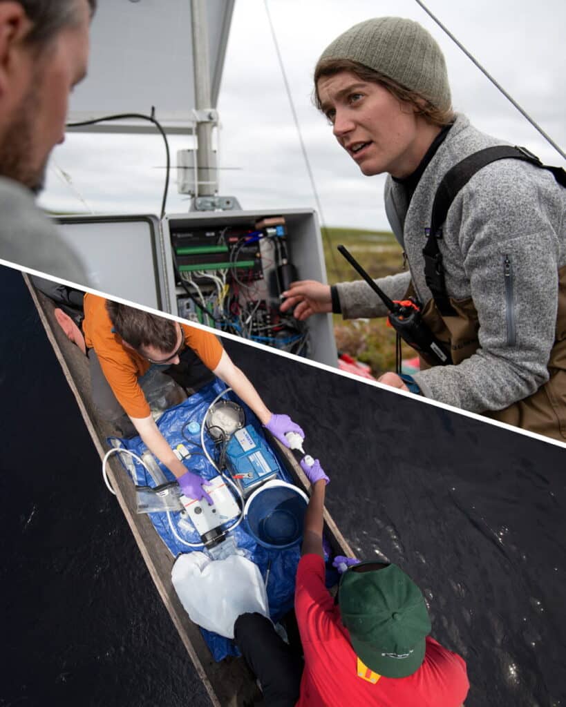
Alves believes maps should be one of those tools. He, along with Woodwell Climate research scientist, Dr. Manoela Machado, has been spearheading a series of workshops designed to help Indigenous fire brigades build the skills of cartography and geographic information systems (GIS). Strong GIS knowledge allows fire crews to make use of data to guide decisions about both on- and off-season fire management activities— both of which will become more critical as the climate warms and fire becomes more prevalent and difficult to control.
Brazil’s fiery landscape
It is supposed to be raining in Roraima right now, but the winter has been dry this year. Climate change has been elongating dry seasons in many regions of the country, increasing the time that ecosystems are prone to burning.
In the Amazon, fires are set intentionally as a part of the deforestation process. Land grabbers use fire to clear the piled vegetation that was cut to make way for cattle ranching, which later will be converted to cropland. With climate shifts, these fires are now more likely to escape into drier and weakened surrounding forests. In Central Brazil, the savana and seasonal wetland ecosystems of the Cerrado and Pantanal have co-evolved with varying levels of frequency and intensity of fire. But prolonged drought and rising temperatures have turned fire seasons into crisis seasons.
Indigenous communities across Brazil have used fire for millennia, working with the ecosystem to promote culturally important species. With climate change extending fire seasons, traditional calendars are also shifting, as the time available for safe burning shrinks. Communities are also facing incursions into their territories from runaway fires ignited on nearby farms.
The world got a taste of the scope of the crisis in 2019 when, during an already record-breaking summer of fire, land grabbers in the Amazon intentionally set so many fires in a single day that the smoke traveled to the City of São Paulo hundreds of miles away.
“The sky in São Paulo became dark at 3pm. And then the world started paying attention to fires in the Amazon,” says Machado. Protecting Brazil’s forests from fire, especially the carbon-rich Amazon rainforest, became a much higher priority for the international community.
Brazil has an extensive wildland fire fighting system, composed of both official and voluntary brigades, supported by various government agencies to operate across private lands, protected public lands, and Indigenous territories. Amidst the increased urgency to quell fires, Machado was interested in understanding what brigades at different jurisdiction levels might need to be more effective during crisis months. She herself has extensive expertise in geospatial software and analysis and wondered whether organizations like Woodwell Climate and IPAM could help by providing data on terrain, weather patterns, vegetation type, and other field-relevant information.
So Machado and Senior Scientist Dr. Marcia Macedo, conducted a needs assessment of the firefighting system to identify what analyses might be most useful.
“The answer was a little bit different, depending on who we were talking to,” says Macedo. “But when we spoke to the Indigenous fire brigades, one of the things that came out right away was not just a desire for spatial data, but for training in spatial analysis. They wanted to be able to work with the data the same way we did.”
Two ways of knowing the land
For the Indigenous communities of Brazil, maps aren’t needed for navigating their territory the way Google Maps might be for someone walking in unfamiliar lands.
“The Indigenous peoples of Brazil have a great understanding of their territory,” says Alves. “We show them an image and they recognize some river or some landmark. They can see it immediately in the satellite view.”
Instead, geospatial data offers another way of communicating their innate knowledge of the land. For the Indigenous fire brigades Machado and Macedo spoke with, the ability to use the same GIS tools that scientists use, and make maps the way a government agency like Brazil’s Institute of the Environment and Renewable Natural Resources (IBAMA) might, is invaluable to advocating for themselves in non-Indigenous spaces.
“To be able to make their own maps can strengthen their autonomy to make decisions, and [aid in] dialogs with people about public policies,” says Alves.
Machado worked with Alves to develop the curriculum for a series of workshops that would help teach the foundations of GIS to fire brigade members from Indigenous territories across Brazil. The first was held in Brasília in 2022, and three more have followed since, the class in Roraima most recently.
Each workshop begins with the basics—latitude and longitude, hemispheres, projections. Alves is a natural teacher, and makes use of props, metaphors, and activities like drawing on the printed maps to make the concepts feel more tangible.
On later days of the workshop, as participants get familiar with QGIS, a free map-making software, Alves sometimes adapts the suggested curriculum to the needs of the communities in attendance.
“For example, in one class we were presenting topographic maps, and they said ‘this is really, really, useful for us,’” says Alves. “So we changed that part of the course to solve for the question they were dealing with.”
By the end of the course, participants have successfully created maps relevant to their own territories. Seeing their own homes represented in map form, Machado says, connects them more strongly to the material.
“You could see the pride on their face,” Machado says. “They recognize every element of that map because they built it. They made each decision of what to show on the map.”
The women’s brigade
Ana Shelley Xerente of the Xerente people had watched her husband work on their territory’s official fire brigade for 13 years before she decided she’d like to try her hand at it as well. Over the years raising her two children, she observed changes occurring in the native Cerrado ecosystem of the Xerente territory—hotter temperatures, drying streams, more fires.
“Nowadays, right after the rain, it’s basically dry,” says Ana Shelley. “All due to climate change.”
She felt a strong duty to protect the environment, and told her husband she’d like to work at Prevfogo, the firefighting arm of Brazil’s Institute of the Environment and Renewable Natural Resources (IBAMA), like him.
“He kept teasing me. ‘There’s no way you could handle that,’” Ana Shelley says. “But I kept talking about it and he came up with the idea of creating a volunteer brigade.”
Volunteer brigades support official brigades, including with that critical non-crisis season prevention work. In 2021, responding to interest from Ana Shelley and others in the territory, Prevfogo and the National Indian Foundation (FUNAI) provided support to start an all-woman volunteer brigade— the first in Brazil. Ana Shelley drove her team of 29 women from village to village, speaking to elders, educating children, re-planting vegetation around headwater streams, and discussing how climate change has affected their traditional calendar for cultural burning.
“We have our own calendar, made by our elders. It marks the rainy season and the dry season, when burning isn’t allowed. So we went through the whole territory, talking to people about what fire brings, the impact it has on humans and animals, and there was a significant reduction [in fires],” Ana Shelley says.
Ana Shelley began to stand out as a leader among the volunteers. In 2024, when her husband left his role as president of the official territory brigade to pursue work with FUNAI, she was asked to fill in for the remainder of his term. At the start of 2025, she was named president for her own four-year term, and has eagerly assumed the responsibility of organizing the activities of 74 Indigenous firefighters, both men and women.
“Everything is new to me, being a brigade chief. And since in our community it’s mostly men who call the shots, it causes an impact, because now the chief is a woman, so it’s all new to them, too,” Ana Shelley says. “I learn a lot from them, and I also share with them what I know. I’m sure it’s going to be challenging, but I also know it’s going to bring a lot of good results.”
Classroom representation
The second GIS workshop was hosted in Ana Shelley’s own territory in Tocantins, but only her husband participated in the course. In fact, midway through the workshop, Machado looked around and wondered why, in a territory with an established brigade of motivated female fire fighters, she was the only woman in the classroom.
Despite not being in operation for as long as the men’s brigades, the brigadistas were eager to perform at the same level. Perhaps, Machado wondered, the workshops could be an opportunity to level the playing field.
She suggested hosting a women’s-only brigade training to encourage their participation, giving women a chance to learn alongside others with similar experiences. The first one took place in Maranhão in June, followed by the one in Roraima.
Macedo says this kind of peer representation is critical to the success of capacity sharing efforts like this one.
“Peer-to-peer teaching and knowledge sharing among people who are living the same reality is almost always more effective than us scientists standing at the front [of a class],” Macedo says.
The brigadistas of Roraima are the clear result of women’s representation on fire brigades, which started in Tocantins with Ana Shelley and has now unfurled across the country. Roraima was the first Brazilian state to formalize all-female fire brigades with the Brigada Pataxibas— a multi-territory collective of female firefighters. During the closing ceremony for the workshop in Roraima a Tuxaua, or elderly community member honored for their wisdom, named Azila stood to point out the bravery of the women assembled, who had accomplished things she never had the opportunity to do in her youth.
Brigade participation has also begun to open doors for women even beyond their territories.
“Some have become teachers, others are in college. It has broadened their horizons. We’ve inspired many women across Brazil,” says Ana Shelley.
According to Machado, the GIS training offers all participants, men and women, the opportunity to tell their own stories on their own terms.
“Maps tell stories,” says Machado. “So the importance of all community members being able to build their own maps is that it allows them to control the narrative. They control how their story is told, instead of waiting for someone else to build a map and tell the story for them.”
The future of fire management
For now, the workshops are planned and hosted on an ad hoc basis, as funding allows. But Macedo sees a pressing need to scale up. The more brigades participate, the more excitement grows for the material.
“If we offered one of these a month for a while, we still wouldn’t be able to meet the demand for them,” says Macedo.
At some point, Macedo says, the project will have to shift to a “training the trainers” strategy. The team envisions a model where the most engaged workshop participants are taught the skills needed not just to make maps but to teach others, expanding this knowledge further and faster than Alves, Machado, and Macedo could on their own. Technology access is another limiter. Some Indigenous communities have access to laptops at central headquarters but it is not common for each community to have its own laptop and almost no individual brigade members do. More laptops would allow workshop participants to continue practicing their skills on their own time.
Policies in Brazil have also begun to shift to open additional opportunities. In 2024, the country passed a new Integrated Fire Management law that will require greater coordination among different brigade jurisdictions for pre-season and mid-season firefighting activities. The law places a specific emphasis on incorporating traditional knowledge. Macedo says she thinks the GIS workshops could contribute to this greater movement and help position Indigenous communities as central to the country’s fire management policies.
When Ana Shelley reflects on how much her brigades have already been able to accomplish, and the possibilities on the horizon, she is hopeful.
“I see a much better future.”
Setembro de 2025 — Nas margens do Lago Caracaranã, no interior do estado brasileiro de Roraima, um grupo de brigadistas indígenas se reúne em torno de mapas impressos em papel. Elas vieram a este ponto de encontro à beira do lago desde seus territórios em todo o estado, e até de outros estados, para aprender sobre mapas com o Dr. Ray Pinheiro Alves, analista de pesquisa do Instituto de Pesquisa Ambiental da Amazônia (IPAM). Alves direciona cada brigadista para um mapa de seu território, completamente sem rótulos. Ele distribui materiais de desenho e, em poucos instantes, as brigadistas já estão perfeitamente orientadas no mapa, traçando de memória rios conhecidos, locais de moradia e pontos de referência.
Roraima é o estado mais ao norte do Brasil. Ele atravessa o Equador e abriga desde vastos campos como os que cercam o lago Caracaranã até trechos montanhosos e enevoados de floresta Amazônica. É uma região remota e, por vezes, desconectada do restante do país, mas que sofre com as mesmas pressões da expansão da agricultura e do garimpo ilegal, além do mesmo aumento de fogos destrutivos que frequentemente acompanham o processo de desmatamento. É por isso que as brigadas indígenas aqui estão ansiosas para adotar novas ferramentas que possam ajudá-las a manejar e proteger suas florestas e lares.
Alves acredita que os mapas devem ser uma dessas ferramentas. Ele, juntamente com a pesquisadora do Woodwell Climate, Dra. Manoela Machado, tem liderado uma série de workshops desenvolvidos para ajudar brigadistas indígenas a desenvolverem habilidades em cartografia e sistemas de informações geográficas (SIG). O domínio das ferramentas de SIG permite que brigadistas façam uso de dados para orientar decisões sobre o manejo de fogo, tanto durante quanto fora da temporada de queimadas — atividades que se tornarão cada vez mais essenciais à medida que o clima esquenta e os incêndios se tornam mais prevalentes e difíceis de controlar.
A paisagem ardente do Brasil
Deveria estar chovendo em Roraima agora, mas o inverno tem sido seco este ano. As mudanças climáticas têm prolongado as estações secas em muitas regiões do país, aumentando o período em que os ecossistemas ficam propensos ao fogo.
Na Amazônia, o fogo é provocado intencionalmente como parte do processo de desmatamento. Grileiros usam o fogo para limpar a vegetação acumulada após a derrubada, abrindo espaço para as pastagens, que mais tarde serão convertidas em lavouras. Com as mudanças climáticas, esse fogo tem mais chance de escapar para florestas mais secas e enfraquecidas ao redor. Mais ao centro do Brasil, os ecossistemas de savana e áreas úmidas sazonais do Cerrado e do Pantanal coevoluíram com níveis variados de frequência e intensidade de fogo. Mas a seca prolongada e o aumento das temperaturas transformaram as temporadas de fogo em temporadas de crise.
Comunidades indígenas em todo o Brasil usam o fogo há milênios, trabalhando com o ecossistema para promover espécies culturalmente importantes. Com as mudanças climáticas prolongando as temporadas de fogo, os calendários tradicionais também estão mudando, já que o período disponível para queimadas seguras diminui. As comunidades também estão enfrentando invasões em seus territórios por incêndios descontrolados iniciados em fazendas vizinhas.
O mundo teve um vislumbre da dimensão da crise em 2019, quando, durante um verão já recordista em incêndios, grileiros na Amazônia atearam tantos focos em um único dia que a fumaça percorreu centenas de quilômetros e chegou a encobrir a cidade de São Paulo.
“O céu em São Paulo escureceu às 15h. E então o mundo começou a prestar atenção ao fogo na Amazônia”, diz Machado. Proteger as florestas do Brasil dos incêndios, especialmente Amazônia, rica em carbono, tornou-se uma prioridade muito maior para a comunidade internacional.
O Brasil tem um amplo sistema de combate a incêndios florestais, composto por brigadas oficiais e voluntárias, apoiadas por vários órgãos governamentais para operar em terras privadas, áreas públicas protegidas e Territórios Indígenas. Em meio à crescente urgência de conter incêndios, Machado estava interessada em entender o que brigadas de diferentes níveis de jurisdição poderiam precisar para serem mais eficazes durante os meses de crise. Ela própria tem ampla experiência em análise geoespacial e se perguntou se organizações como Woodwell Climate e IPAM poderiam ajudar fornecendo dados sobre terreno, padrões climáticos, tipo de vegetação e outras informações relevantes para o campo.
Então, Machado e a cientista sênior Dra. Marcia Macedo conduziram uma avaliação das necessidades do sistema de combate a incêndios para identificar quais análises poderiam ser mais úteis.
“A resposta variava um pouco, dependendo de com quem estávamos falando”, diz Macedo. “Mas quando falamos com os brigadistas indígenas, uma das coisas que surgiu de imediato não foi apenas um desejo por dados espaciais, mas por treinamento em análise espacial. Eles queriam poder trabalhar com os dados da mesma forma que nós.”
Duas maneiras de conhecer a terra
Para as comunidades indígenas do Brasil, os mapas não são necessários para navegar em seus territórios da mesma forma que o Google Maps pode ser para alguém caminhando em terras desconhecidas.
“Os povos indígenas do Brasil têm um grande conhecimento dos seus territórios”, diz Alves. “Mostramos uma imagem e eles reconhecem algum rio ou algum marco. Eles veem isso imediatamente na visão de satélite.”
Em vez disso, os dados geoespaciais oferecem outra maneira de comunicar esse conhecimento inato da terra. Para as brigadas indígenas com quem Machado e Macedo conversaram, a capacidade de usar as mesmas ferramentas de SIG que os cientistas usam, e de fazer mapas da mesma forma que um órgão governamental, como o Instituto Brasileiro do Meio Ambiente e dos Recursos Naturais Renováveis (IBAMA) faria, é inestimável para que possam se representar e reivindicar seus interesses em espaços não indígenas.
“Poder fazer os próprios mapas pode fortalecer a autonomia para tomar decisões e [ajudar] nos diálogos sobre políticas públicas”, diz Alves.
Machado trabalhou com Alves para desenvolver o conteúdo de uma série de workshops que ajudariam a ensinar os fundamentos de SIG a brigadistas de Territórios Indígenas em todo o Brasil. O primeiro foi realizado em Brasília em 2022, e outros três se seguiram desde então, sendo a turma de Roraima a mais recente.
Cada workshop começa pelo básico: latitude e longitude, hemisférios, projeções. Alves é um professor nato e faz uso de adereços, metáforas e atividades como desenhar em mapas impressos para tornar os conceitos mais tangíveis.
Nos dias seguintes, à medida que os participantes se familiarizam com o QGIS, um software gratuito de elaboração de mapas, Alves adapta as aulas às necessidades das comunidades presentes.
“Por exemplo, em uma aula estávamos apresentando mapas topográficos, e eles disseram ‘isso é muito, muito útil para nós’”, diz Alves. “Então mudamos o curso para resolver a questão com a qual eles estavam lidando.”
Ao final do curso, os participantes haviam criado mapas relevantes para seus territórios. Ver suas próprias casas representadas em forma de mapa, diz Machado, os conecta mais profundamente ao material.
“Dava para ver o orgulho no rosto delas”, diz Machado. “Elas reconhecem cada elemento daquele mapa porque foram elas que construíram. Elas tomaram cada decisão sobre o que mostrar no mapa.”
A brigada feminina
Ana Shelley Xerente, do povo Xerente, viu seu marido trabalhar na brigada oficial de seu território por 13 anos antes de decidir que também gostaria de experimentar. Ao longo dos anos criando seus dois filhos, ela observou mudanças ocorrendo no ecossistema nativo do Cerrado do território Xerente: temperaturas mais altas, córregos secando, mais incêndios.
“Hoje em dia, logo depois da chuva, já está praticamente seco”, diz Ana Shelley. “Tudo por causa das mudanças climáticas.”
Ela sentiu um forte dever de proteger o meio ambiente e disse ao marido que gostaria de trabalhar no Prevfogo, o braço de combate a incêndios do IBAMA, como ele.
“Ele vivia me provocando. “Não tem como você aguentar isso”, diz Ana Shelley. “Mas eu continuei falando sobre isso e ele teve a ideia de criar uma brigada voluntária.”
As brigadas voluntárias apoiam as brigadas oficiais, inclusive no trabalho crítico de prevenção realizado fora do período de crise. Em 2021, atendendo ao interesse de Ana Shelley e de outras pessoas do território, o PREVFOGO e a FUNAI ofereceram apoio para criar uma brigada voluntária composta exclusivamente por mulheres,— a primeira no Brasil. Ana Shelley levava sua equipe de 29 mulheres de aldeia em aldeia, conversando com anciões, educando crianças, reflorestando margens de nascentes e discutindo como as mudanças climáticas têm afetado o calendário tradicional de queimadas culturais.
“Temos nosso próprio calendário, feito pelos nossos anciões. Ele marca a estação chuvosa e a estação seca, quando a queimada não é permitida. Então, percorremos todo o território, conversando com as pessoas sobre o que o fogo traz, o impacto que ele tem sobre humanos e animais, e houve uma redução significativa [nos incêndios]”, diz Ana Shelley.
Ana Shelley começou a se destacar como líder entre as voluntárias. Em 2024, quando seu marido deixou o cargo de presidente da brigada oficial Xerente para trabalhar na FUNAI, ela foi convidada a substituí-lo pelo restante do mandato dele. No início de 2025, ela foi nomeada presidente para seu próprio mandato de quatro anos e assumiu com entusiasmo a responsabilidade de organizar as atividades de 74 brigadistas indígenas, homens e mulheres.
“Tudo é novo para mim, ser chefe de brigada. E como na nossa comunidade são, na maioria, os homens que tomam as decisões, isso causa um impacto, porque agora a chefe é uma mulher, então é tudo novo para eles também”, diz Ana Shelley. “Eu aprendo muito com eles e compartilho com eles o que eu sei. Tenho certeza de que vai ser desafiador, mas também sei que vai trazer muitos bons resultados.”
Representação em sala de aula
O segundo workshop de SIG foi realizado no território de Ana Shelley, no Tocantins, mas apenas seu marido participou do curso. De fato, em certo momento do workshop, Machado olhou ao redor e se perguntou por que, em um território com uma brigada de mulheres motivadas, ela era a única mulher na sala de aula.
Apesar de não estarem em operação há tanto tempo quanto as brigadas masculinas, as brigadistas estavam ansiosas para atuar no mesmo nível. Talvez, pensou Machado, os workshops pudessem ser uma oportunidade para nivelar o campo de atuação.
Ela sugeriu organizar um treinamento exclusivo para mulheres, incentivando sua a participação e dando às elas a oportunidade de aprender ao lado de outras mulheres com experiências semelhantes. A primeira ocorreu no Maranhão, em junho, seguida pela de Roraima.
Macedo afirma que esse tipo de representatividade entre pares é essencial para o sucesso de iniciativas de compartilhamento de capacidade como este.
“O ensino entre pares e a troca de conhecimento entre pessoas que vivem a mesma realidade são quase sempre mais eficazes do que nós, cientistas, em pé na frente [de uma turma]”, diz Macedo.
As brigadistas de Roraima são o resultado claro da representatividade feminina em brigadas, que começou no Tocantins com Ana Shelley e agora se espalhou pelo país. Roraima foi o primeiro estado brasileiro a formalizar brigadas exclusivamente femininas com a Brigada Pataxibas — um coletivo multiterritorial de mulheres combatentes. Durante a cerimônia de encerramento da oficina em Roraima, uma Tuxaua, ou anciã da comunidade reconhecida por sua sabedoria, chamada Azila, destacou a coragem das mulheres ali reunidas, que haviam alcançado coisas que ela mesma nunca tivera a oportunidade de fazer em sua juventude.
A participação nas brigadas também começou a abrir portas para as mulheres para além de seus territórios.
“Algumas se tornaram professoras, outras estão na faculdade. Ampliou seus horizontes delas. “Inspiramos muitas mulheres em todo o Brasil”, diz Ana Shelley.
Segundo Machado, o treinamento em SIG oferece a todos os participantes, homens e mulheres, a oportunidade de contar suas próprias histórias em seus próprios termos.
“Mapas contam histórias”, diz Machado. “Portanto, a importância de todos os membros da comunidade poderem construir seus próprios mapas é que isso lhes permite controlar a narrativa. Eles controlam como sua história é contada, em vez de esperar que alguém faça um mapa e conte a história por eles.”
O futuro da gestão de incêndios
Por enquanto, os workshops são planejados e realizados de forma ad hoc, conforme o financiamento permite. Mas Macedo vê uma necessidade urgente de expansão. Quanto mais brigadas participam, mais cresce o entusiasmo pelo material.
“Se oferecêssemos um desses por mês durante um tempo, ainda não conseguiríamos atender à demanda”, diz Macedo.
Em algum momento, diz Macedo, o projeto terá que mudar para uma estratégia de “formar formadores”. A equipe imagina um modelo em que os participantes mais engajados do workshop sejam capacitados não apenas para fazer mapas, mas também para ensinar outras pessoas, expandindo esse conhecimento de forma mais ampla e rápida do que Alves, Machado e Macedo conseguiriam sozinhos. O acesso à tecnologia é outro limitador. Algumas comunidades indígenas têm computadores em sedes centrais, mas não é comum cada comunidade possuir o seu, e quase nenhum brigadista tem computador próprio. Mais laptops permitiriam que os participantes dos workshops continuassem praticando suas habilidades de forma autônoma.
As políticas no Brasil também começaram a mudar para abrir novas oportunidades. Em 2024, o país aprovou uma nova lei de Manejo Integrado do Fogo que exigirá maior coordenação entre diferentes jurisdições de brigadas para atividades de prevenção e combate, tanto no início quanto no meio da temporada de fogo. A lei dá ênfase à incorporação do conhecimento tradicional. Macedo diz que acredita que os workshops de SIG podem contribuir para esse movimento maior e ajudar a posicionar as comunidades indígenas como centrais nas políticas nacionais de manejo do fogo.
Quando Ana Shelley reflete sobre o quanto suas brigadas já conseguiram realizar e as possibilidades no horizonte, ela se mostra otimista.
“Eu vejo um futuro muito melhor.”
Every five years, all 195 signatories of the 2015 Paris Agreement must submit updated plans to reduce their greenhouse gas emissions to limit global warming. These plans, known as Nationally Determined Contributions (NDCs), are key components of the agreement and represent countries’ highest ambitions for emissions reductions over the next decade.
“The NDC is a pledge,” Director of International Government Relations at Woodwell Climate Dr. Matti Goldberg says. “It’s a pledge by a government to reduce their emissions by a certain amount, by a certain time frame. It can also be a pledge of taking certain types of actions. Each NDC also contains plans and measures to put it into action.”
This year, countries must submit their third NDC ahead of COP30 in Belém, Brazil.
How do NDCs fit into the Paris Agreement?
The Paris Agreement is a legally-binding international treaty under the UNFCCC. The treaty states that signatories should work together to limit global temperature increase to “well under 2°C” above pre-industrial levels and pursue efforts to keep the increase below 1.5°C. Nationally Determined Contributions outline how countries plan to achieve this goal and take other measures as part of the global climate effort.
Each NDC must build upon a country’s previous submission and reflect the party’s “highest possible ambition,” according to the Paris Agreement. While parties are legally required to submit an NDC and pursue actions to reach the target, they are “not legally bound to reach the target,” Goldberg says. “It’s a gigantic loophole in a way…although such flexibility is obviously necessary for countries to agree to this, and it does create a structure of pressure.”
After NDCs are submitted, the UNFCCC assesses the combined impact of countries’ NDCs on projected global emissions in a synthesis report. Parties in the Paris agreement also submit a Biennial Transparency Report (BTR) every two years, which outlines each country’s progress made towards accomplishing their NDCs.
“It’s the country’s own assessment,” Goldberg says. “But if a country announces a metric, then others can, of course, also look at whether that metric is being followed. This information creates the basis for civil society and other governments to put pressure on those governments.” Further transparency is created by a process where international experts review each country’s biennial reports.
Despite the ambitious intent of NDCs, Executive Secretary of the United Nations Framework Convention on Climate Change (UNFCCC) Simon Stiell determined last November that previous pledges fell “miles short of what’s needed to stop global heating from crippling every economy and wrecking billions of lives and livelihoods across every country.”
What is in the 2025 NDCs?
NDCs were initially due in February 2025, but with only 13 Parties submitting on time, the UNFCCC Secretariat announced a cut-off date in September to have enough time to prepare its synthesis before the start of COP30 in November. China, the United States, India, the European Union, Russia and Brazil were the world’s top emitters in 2023. Together, these six parties accounted for 62.7% of all global emissions. Of the top greenhouse gas emitters, only the U.S. and Brazil sent in their NDCs as of early September 2025.
The United States submitted its NDC in 2024 under the Biden Administration and set a target of reducing its net greenhouse gas emissions by 61 to 66% below 2005 levels in 2035. After taking office, President Trump issued an executive order announcing the U.S.’s intent to withdraw from the Paris Agreement, which will go into effect in 2026. After January 2026, the U.S. will no longer be required to submit new NDCs or Biennial Transparency Reports.
Despite the country’s withdrawal, Goldberg says the U.S. may see a reduction in greenhouse gas emissions because of its continuing transition from coal to natural gas, renewables and nuclear power — which, according to Goldberg, is driven more by economics and less by policy. Still, Dr. Christopher Schwalm, Vice President of Science at Woodwell Climate, predicts there is “no way” the United States will hit the targets set out in the NDC given the current global political climate. Even if the U.S. does reach its goals, the NDC still does not align with the global 1.5°C limit, according to the Climate Action Tracker. Schwalm calls the 1.5°C target “dead as a doornail.” To reach this goal, we would have needed global greenhouse gas emissions to peak by 2025.
Brazil’s most recent NDC states a goal of reducing greenhouse gas emissions 59% to 67% compared to its 2005 emissions. Goldberg calls it a “pretty ambitious” absolute target for a country classified as a developing country under the UNFCCC. However, the Brazilian climate organization Observatório do Clima states the NDC goals do not align with the global 1.5°C limit.
How could reaching targets in NDCs impact warming trajectories?
Woodwell Climate research scientist Dr. Abigail Lute wanted to see how much of a difference just two of the top-emitting countries’ NDCs could make.
“Are we moving the needle here or not?” she says. “How much are we moving the needle? Are we moving it enough to avoid 2°C? That’s the big picture, to see how ambitious these new pledges are.”
Lute modeled how both the U.S. and Brazil’s promises together could change the global warming trajectory using a “middle-of-the-road” scenario for future greenhouse gas emissions — though, at the moment, that scenario might be more optimistic than our current trajectory, she says.
For the first ten to 20 years after implementing the NDCs, temperatures will temporarily increase. This is due to the reduction in polluting gases such as sulfates that actually have a cooling effect in the atmosphere. After about a decade or two, the reduction in warming gases such as methane and carbon dioxide will cause temperatures to fall.
According to Lute’s calculations, under moderate emissions scenarios, the probability of exceeding 2°C is 25% by 2050 and 78% by 2100. If both the U.S. and Brazil reach their NDC targets, the probability of exceeding 2°C stays about the same for 2050 but drops down to 73% for 2100.
Global warming is expected to reach 1.8°C by 2050 and 2.3°C by 2100 under the medium emissions scenario. With the U.S. and Brazil’s combined NDCs, Lute expects warming to be reduced by about 0.01°C in 2050 and 0.06°C by 2100.
While these contributions may seem small, Brazil and the U.S. only represent two of the 195 parties in the Paris Agreement.
“It’s two of the larger ones for sure, but it’s only two,” Lute says. “If we extrapolate it to everybody, then it can make a meaningful difference…the story here is that everybody needs to contribute. This is a collective problem, and even one large country can’t solve it.”
From the Amazon to the Congo Basin, the largest remainder of tropical forest lies in Brazil and the Democratic Republic of Congo – taking up nearly 4 million square miles of land. As epicenters of biodiversity and carbon storage, these forests serve as the stabilizers of our climate. Yet many tropical forests around the world are disappearing as climate change and human activity drive deforestation every year.
Despite covering only 6% of the planet, tropical forests play a critical role in climate control. They prevent atmospheric warming by storing carbon, dispersing heat, releasing cooling water into the air, and helping to create clouds. They also help regulate air quality, soil health, and the water cycle. Keeping them standing is one of our best natural climate solutions.
At the 2021 United Nations Climate Change Conference (COP26), over 100 world leaders pledged to halt and reverse forest loss and land degradation by 2030, but deforestation has continued year over year. Under our current economic system, forests are often more valuable cut and cleared than left standing.
But this year, a new solution has appeared on the horizon: a fund to incentivize tropical forest conservation.
The tropical deforestation crisis
In 2024, the tropics lost 6.7 million hectares of primary forest – old forest that has been relatively undisturbed by humans – at a rate of 18 soccer fields per minute. It was a record-breaking year for primary forest loss and the fastest rate of primary forest deforestation on record, with much of the increase driven by wildfire.
Bolivia and the Democratic Republic of the Congo saw some of the highest levels of primary forest loss on record. But Brazil, the world’s largest tropical forest nation and home to over half of the Amazon rainforest, took the biggest hit. Over 40% of all tropical primary forest loss in 2024 occurred in Brazil.
The main forces behind forest loss worldwide are all human activities: agricultural expansion, mining, logging, and infrastructure development. Dr. Ludmila Rattis, Assistant Scientist and General Coordinator of Woodwell’s Tanguro Field Station, works on the Brazilian agricultural frontier to understand the impacts of agricultural intensification.
“Today, the number one driver of deforestation in the Amazon and Cerrado is land grabbing,” Rattis says.
Land grabbing refers to the control and clearing of large plots of land by a person or entity without clear rights to do so. In Brazil, land grabbing has been common since colonial times, when legislation restricted access to land. Today, nearly 50 million hectares of public forest in the Brazilian Amazon remains “undesignated” – meaning the land has not been formally designated by the government for a specific purpose – which leaves it highly vulnerable to grabbing.
Brazil is a major producer of agricultural commodities including beef, soybeans, and coffee. Because the country has a large amount of undesignated land with unclear regulations, land grabbing for agricultural production is profitable – and cleared forests are more financially valuable than standing ones. Brazilian law also allows the legal deforestation of some trees on private property, as long as 80% of forests on the property remain standing.
In late 2023, the Brazilian government proposed the Tropical Forest Forever Facility (TFFF) as a new financial solution that would pay tropical countries to keep their forests standing. Designed to generate and distribute $4 billion each year, it would complement other sources of finance by focusing incentives on forest conservation.
How does the TFFF work?
The TFFF is a global investment fund that proposes to use finance and investment strategies to generate annual payments to tropical forest countries that conserve and restore their forests. First introduced at COP28, the fund would provide tropical forest nations with large-scale, predictable payments based on how much forest cover they maintain.
The fund will raise money from both the public and private sectors, starting with $125 billion – $25 billion from government sponsors in long-term loans and guarantees and $100 billion from long-term, low-interest bond sales to private sector investors. The money raised will be invested into bonds with a high rate of return to generate revenue. Part of the revenue will be used to pay down interest on loans from bond-holders and government sponsors, with the remaining earnings being allocated to fund annual payments to tropical forest nations.
Frances Seymour, Senior Policy Advisor at Woodwell, is working on forest finance priorities leading up to COP30 this year.
“The innovative feature is the use of public capital to reduce the risk of non-repayment to private investors,” Seymour says.
The return generated by the fund would be paid out to eligible tropical forest countries at an initial rate of $4 per hectare of forest. It would be distributed to eligible governments with a deduction applied for every hectare deforested or degraded.
In order to be eligible for the fund, a country must be a developing nation with tropical or subtropical broadleaf moist forests – forests characterized by year-round warmth, high levels of precipitation, and trees with broad, flat leaves. Additionally, the deforestation rate during the year the country adheres to the TFFF must be lower than the previous year.
To track deforestation rates, participating nations would need to use remote sensing technologies such as satellite imagery. For example, Brazil’s National Institute for Space Research (INPE) monitors tree cover loss using satellite-based systems. Countries that do not have the ability to monitor their own forests would be allowed to use approved third-party methods and data.
How many trees make a forest?
Areas eligible for forest payments must also have more than 20% canopy cover, which refers to the percentage of the upper layer of trees in a forest that obscures light passing through. But some people argue that the proposed threshold isn’t high enough.
Scientists at Woodwell Climate, including Associate Scientist Glenn Bush and Research Assistant Patrick Fedor, are pushing for higher canopy cover thresholds for the fund.
“The problem is that most of us who work in tropical forests and know them well would say that a patch of land which only has 20% of forest cover isn’t a forest anymore – it’s a field,” Bush says.
A landscape with a few large trees scattered around may have canopies that register at 20% cover despite no longer functioning as a forest. Scientists recommend increasing the canopy cover threshold to 60% or even 80% to focus on high-value intact tropical forest areas and prevent cleared areas from qualifying for TFFF benefits.
In a memo to TFFF Secretariat Andre Aquino, Bush and Fedor assessed management costs and social benefits of conserving tropical forests in Brazil and the DRC. They found that with raised canopy thresholds and adjusted payments, the TFFF could help protect more biodiverse and climate resilient forests without increasing the fund’s total budget. The counter argument, however, is that any forests below the increased threshold may face a higher risk of being permanently converted to another use rather than restored if not included in the scheme.
“The biggest thing is to increase canopy cover because we want resilient forests,” Fedor says. “We’re trying to keep forests fully intact.”
COP30 and the future of tropical forests
While the specifics of the fund aren’t fully agreed upon, the general consensus is that the global effort would make a significant positive change for tropical forest nations. By providing a source of predictable budget support for forest conservation and management, tropical forest nations could bring environmental goals to the forefront of government policy and action.
“This is a really long-term commitment to what could be potentially transformational change,” Bush says.
If successful, the model has the potential to apply to other efforts beyond forest conservation. The TFFF model, Seymour says, could be replicated to finance efforts such as girls’ education or eradicating malaria, two areas that are facing pressures from recent reductions in development aid from wealthy countries.
The proposed TFFF model also puts an emphasis on Indigenous communities and their contribution to forest conservation by requiring a minimum of 20% of annual payments to each country – a global amount totalling at least $800 million annually – to be allocated to Indigenous and local forest communities.
“The focus on Indigenous Peoples and reinforcing land rights is really critical,” Bush says. “That’s the first time a fund of this sort has actually involved Indigenous Peoples groups in its design in such an early stage.”
Research has shown that Indigenous communities are the key to protecting tropical forests. Managing over half of the world’s remaining intact forests, Indigenous tropical forest communities experience more carbon capture, less carbon loss, and less tree cover loss than other lands. When Indigenous land rights are enforced, forests thrive.
“It’s an innovative policy that’s hopefully going to promote good change and good environmental outcomes,” Fedor says. “It changes the economics of a forest’s value.”
During New York Climate Week in September, Brazilian President Luiz Inácio Lula da Silva announced that Brazil itself would invest $1 billion in sponsor capital, challenging other governments to do their part as well. The Brazilian government plans to formally launch TFFF at COP30 in Belém, Brazil in November. With the world’s biggest climate event hosted in the world’s biggest tropical forest nation, tropical forests will feature heavily on the international agenda. Roughly 45,000 policymakers, government negotiators, scientists, activists, and Indigenous leaders will be descending on the city at the mouth of the Amazon, placing a major spotlight on one of the very regions the TFFF is designed to protect.
“If there were ever a moment when a big idea like this could get the political and financial support that it needs to get off the ground,” Seymour says, “this is it.”
Woodwell Climate Research Center is thrilled to announce the receipt of a $10 million unrestricted gift from renowned philanthropist MacKenzie Scott. At a time when scientific institutions across the United States are facing unprecedented challenges, this generous gift will support the long-term financial strength of the Center and its critical mission of conducting groundbreaking research to drive science-based solutions to the climate crisis.
Over the past three years, MacKenzie Scott has supported the Center’s Permafrost Pathways initiative through the TED Audacious Project. This new gift builds upon that tremendous support and makes it possible for the Center to leverage critical funds throughout the Center’s work across the globe.
“In a moment where climate science is under attack, this support strengthens our resolve and bolsters our confidence to act boldly and pursue our most innovative ideas,” said Dr. Max Holmes, President and CEO of Woodwell Climate. “An unrestricted gift of this size is extraordinary, and stands as a ringing endorsement of Woodwell’s mission and values from one of the world’s most influential philanthropists. We are deeply inspired by and grateful for this act of generosity and the remarkable trust it shows in our vision and impact.”
For forty years Woodwell Climate has pursued the critical work of scientific research to help leaders and communities across the country—and around the world—curb climate change and cope with the increasingly damaging impacts. With this key investment, Woodwell will continue and accelerate efforts to find climate solutions, intensify its commitment to the highest standard of science, and aspire to ever greater courage and creativity.
In a comment published in Nature Climate Change, Mark Bradford, the E.H. Harriman Professor of Soils and Ecosystem Ecology, and Yale School of the Environment research scientists Sara Kuebbing and Alexander Polussa ’25 PhD, together with colleagues Emily Oldfield ’05, ’11 MESc, ’19 PhD, of Environmental Defense Fund (EDF) and Jonathan Sanderman of the Woodwell Climate Research Center, argue that the scientific evidence supporting soil carbon’s role in mitigating climate change remains too weak to meet the standards required for policy and carbon markets.
Read more here.
On September 19, Woodwell Climate submitted public comment on the U.S. Forest Service’s proposed rulemaking to rescind the 2001 Roadless Area Conservation Rule, also known as the Roadless Rule. This rule banned logging and the creation of new logging roads in 58 million acres of National forests.
The federal agency’s intent to rescind the Roadless Rule aligns with the presidential Executive Order, “Unleashing Prosperity through Deregulation” which seeks to remove obstacles to extracting natural resources on public lands. Additionally, the agency claims the repeal of the rule will allow forest managers to remove trees from “overstocked forests” to prevent wildfire and disease.
Woodwell Climate strongly opposes the rescission of the rule, citing the best available science that shows increased roadways and subsequent logging will result in ecological degradation, increased wildfire, and loss of critical carbon stocks.
“The Roadless Rule currently protects millions of acres from extractive activities that would result in ecosystem degradation and increased vulnerability to wildfire,” writes Senior Scientist Rich Birdsey in the comment. “Rescinding the Roadless Rule would harm many public uses of the land, cause significant emissions of greenhouse gases, and destroy critical habitat for many species of wildlife.”
Federal forests have major carbon storage and climate mitigation potential, absorbing approximately 3% of U.S. emissions from fossil fuel burning each year. Mature and old growth forests are responsible for the majority of that, and the Roadless Rule has been instrumental in preventing the logging of these important forests, including the Tongass National Forest in Alaska.
“Increased logging is the single greatest threat to these forests and the carbon they hold — and it is the threat we most directly control,” the Woodwell Climate comment states. “As the impacts of climate change become more extreme and damaging, we should prioritize protecting mature and old growth forests on federal lands, not harvesting them.”
Additionally, studies show that road building into previously undisturbed forests actually increases vulnerability to fire. This is because most wildfires are caused by human ignitions which become more common with better access roads. Undisturbed mature and old-growth forest ecosystems are also more resilient to wildfires compared to forests that are actively logged and managed.
Read the full public comment here.
When it comes to sucking carbon dioxide out of the atmosphere, trees and forests are well-known champions. But when it comes to sequestering methane, their role is much more complicated. Forest ecosystems sometimes absorb methane, other times they emit it — creating a complex exchange of gases that scientists are only beginning to understand. Boreal forests across Canada, Alaska, Scandinavia, and Russia can sometimes be methane sinks, but they’re also set to become major emitters as climate change accelerates.
That’s the challenge the Boreal Biosequester project is tackling. By deploying newly developed methane detecting chambers at Howland Research Forest in Maine, Woodwell Climate Associate Scientist Dr. Jennifer Watts and Senior Research Scientist Kathleen Savage, along with collaborators from Arizona State University and University of Maine Orono plan to measure methane flows on a granular level to understand which bacteria consume it and how they function across the ecosystem.
Once they’ve mapped these methane-munching microbes—called methanotrophs—across varying tree species, temperatures, and seasonal shifts, the researchers want to publish their findings so governments, land trusts and foresters can enhance the activity and presence of these climate superstars, transforming ecosystems from methane sources into sinks.
Why methane matters
Methane has been overlooked in climate discussions, which largely focus on carbon dioxide, but it’s 87 times more powerful at trapping heat over a 20 year period. Atmospheric levels of methane are now 2.6 times higher than pre-industrial levels—the highest they’ve been in 800,000 years. Crucially, methane emissions from boreal forests are expected to rise or even double as temperatures rise.
Natural environments, such as wetlands and forests, account for a large portion of global methane emissions, which is why finding nature-based solutions to bring down emissions is such an important area of research. Boreal Biosequester’s approach offers the chance to turn natural sources into sinks, while also providing co-benefits such as enhanced biodiversity, wildlife habitats, flood reduction, erosion prevention, and improved air quality.
“If the methanotrophs are there, why not learn to work with them as effectively as possible?” says Watts. “If we were to work with human technology to reduce methane, you’d have to build something energy-intensive. This is a passive way to work with the forest sustainably. If we leave a forest to grow or regenerate, or if we afforest, we can both draw down CO2 and, we hope, consume methane.”
The genesis of the project
Watts and Savage were initially looking at methane sources and sinks for the US National Science Foundation. At first, they focused on soils, which were at the time considered the primary drivers of whether forests were sources or sinks. Then a groundbreaking paper revealed trees’ crucial role in methane uptake. With microbial ecologist Dr. Hinsby Cadillo-Quiroz from Arizona State University, they decided to study methane fluxes around tree trunks and canopies as well as in the soil, and sought funding from CarbonFix to carry out this study.
“When we looked at the canopy level, we could see net consumption, but soil data were all over the place,” Watts explains. “The data showed something important happening between the soils and treetops.”
The world of methanotrophs on plant surfaces is largely uncharted. The team will isolate and study these bacteria in labs while measuring methane consumption across soils, trunks, and canopies through different seasons and climates.
“We’re really the explorers venturing into this new micro-universe,” says Watts. “We know there are microbes out there, we just need to get to know them.”
Only in the last 15 years could methane gas be measured accurately at this scale. The team is uniquely positioned at Howland Forest, which has rare historical methane flux data from eddy covariance towers (structures measuring the exchange of gases) dating to 2011, plus access to both pristine and harvested forest areas for direct comparison.
The Method
CarbonFix’s grant will be used for the first phase to map methanotroph behavior and measuring fluxes across forest layers across the course of a year. Once they’ve secured additional funding, the team will identify optimal conditions for methane consumption across different tree species and environments. Next, they’ll test hypotheses in greenhouse settings, demonstrating how specific tree species can convert methane-emitting wetlands into methane-consuming ecosystems.
Finally, they’ll share findings through reports and presentations targeting governments, land trusts, foresters, and carbon markets to implement these practices in forest management.
Potential impact
For now, the team will focus on working out how methanotrophs function, and the conditions in which they thrive.
“A tiny creature, like a methanotroph, can influence a tree in many ways: it can fix nitrogen, it can clean metabolites. But the true beauty of this partnership is that a single tree could host methanotrophs in many ways and a thousand trees can host methanotrophs in a million ways. We just need to figure out how to channel this partnership to remove many tons of methane molecules. Achieving that would be a major breakthrough to help gain time against climate change,” says Cadillo-Quiroz.
The findings may extend beyond forests to landfills, agriculture, logging, or fire-damaged areas — countless applications where understanding and influencing methane fluxes through bacteria could prove transformative.
What’s more, if the team’s findings show how methanotrophs can be inoculated into new forests, they could become part of every new reforestation project.
Reforestation is urgently needed: between 2001-2023, Canada, Alaska, and the Northern US lost over 70 million hectares of forest — three times the UK’s landmass — from fire and harvest. Most of these wet soil areas are net methane emitters. Reforesting and inoculating them with methanotrophs could create carbon and methane sequestration superheroes. The team estimates targeted afforestation could remove over 10 million metric tons of methane — reducing 30-40% of high-latitude methane budgets while simultaneously sequestering CO2.
But for now, there’s lots of work to be done. The team of four are rolling up their sleeves for fieldwork and lab analysis.
“At minimum, it will be fascinating data filling knowledge gaps about methane uptake,” says Savage. “If we can remove methane short-term, we have leeway to address more challenging CO2 elements requiring extensive work.”
Watts adds: “Our group is always thinking about how what we do now will impact society later. I’m excited to develop methodologies that we can share worldwide, creating community transformation for people across the planet.”