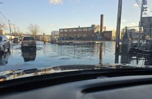
Floodwaters are coming for Chelsea, MA. The city is meeting them head on.
Climate risk assessment from Woodwell is helping Chelsea shape its infrastructure and plan for a wetter future
Dominick Dusseau measures storm drain height with a laser. These measurements were later incorporated into flood risk models.
photo by Dominick Dusseau
The city of Chelsea, Massachusetts persevered through the American Revolution and two great fires. Now its resilience is being tested by climate change, as rising sea levels and more intense storms have begun sending frequent flood waters into the city.
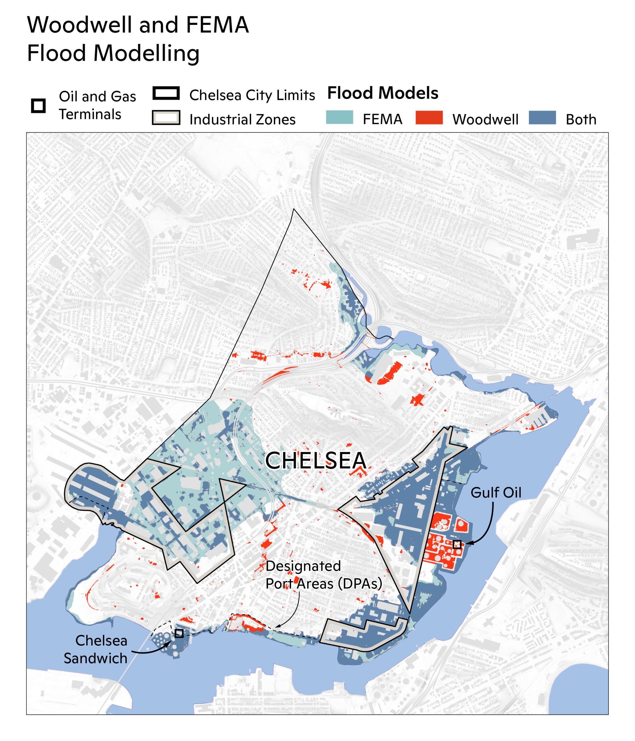
Woodwell Climate Research Center recently conducted a thorough analysis of flood risk in Chelsea, identifying where flooding is likely to increase with climate change. The picture it paints is one where the city’s most vulnerable citizens get hit the hardest.
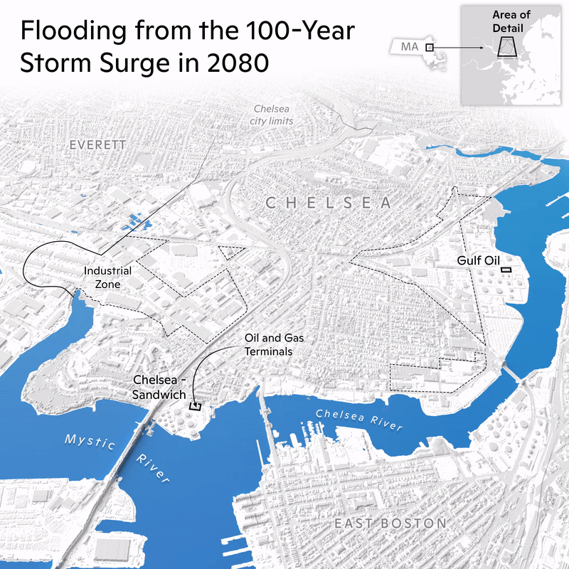
Located north of Boston where Chelsea Creek merges into the Mystic River and the Boston Harbor, Chelsea is vulnerable to two forms of flooding—storm surge from the harbor and extreme rainfall events. Currently, 15% of the city falls within an area of potential flooding. That number will more than double to 34% by 2081.
The return interval of high intensity flooding events will also increase. Scientists use the term “1-in-100 year events” to refer to the kind of large-scale flooding that has a 1% chance of occurring each year. Woodwell calculated that today’s 1-in-100 year rainfall events could become three times as likely by mid-century, and 1-in-100 year storm surge events could be annual occurrences by 2081. That would be like the city of Chelsea experiencing flooding proportional to Hurricane Sandy every year.
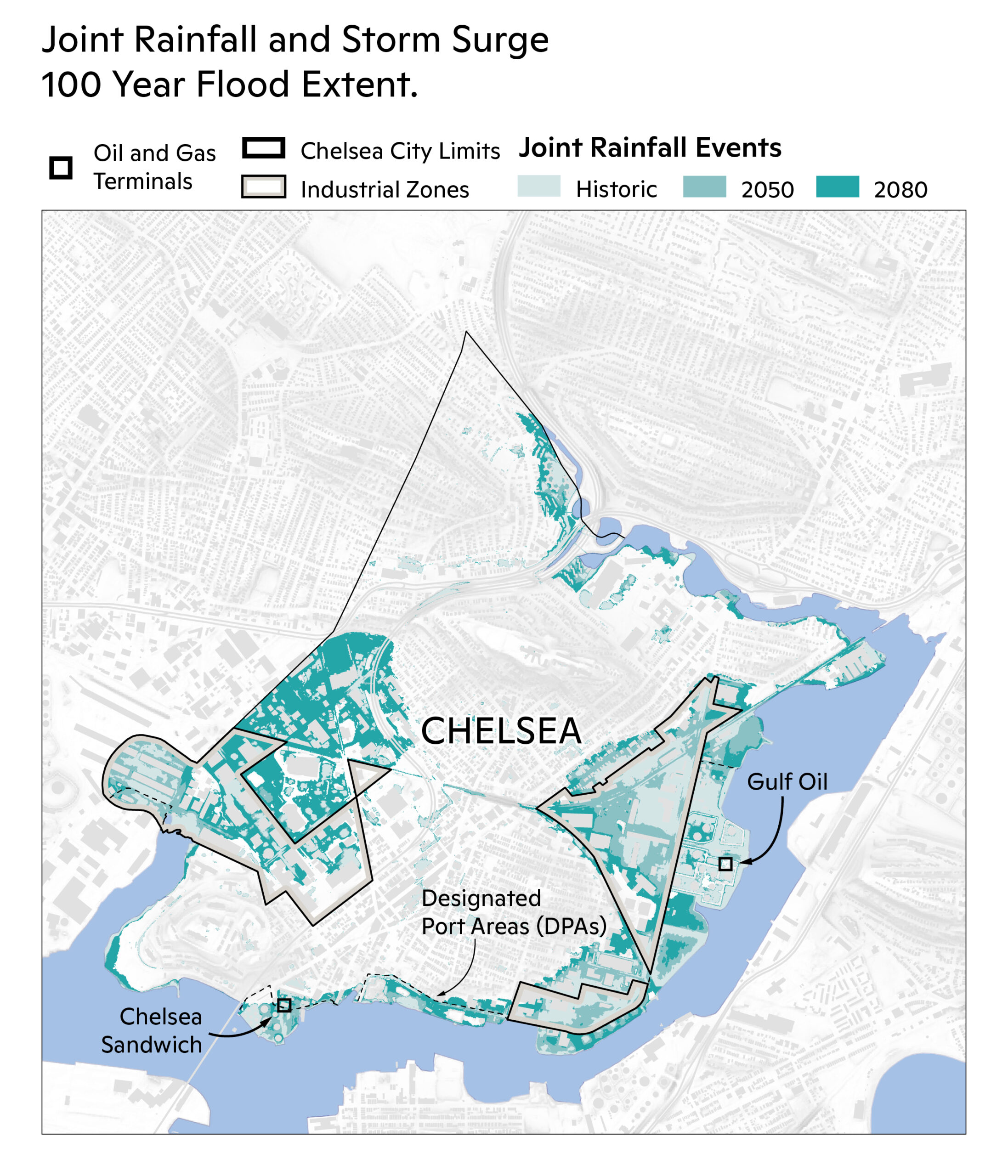
map by Carl Churchill
Heavy industry, low incomes, high risk
Chelsea was settled on a salt marsh punctuated by five hills. The city was developed from the high ground down, and much of the marsh and wetlands around Island End and Chelsea Creek were filled in over the city’s history. These low lying areas form the city’s vulnerable floodplain.
According to Woodwell’s analysis, that floodplain contains much of the city’s vital industry. Two oil terminals sit on Chelsea’s waterfront—the Chelsea Sandwich and Gulf Oil terminals. Here, petroleum, natural gas, and other petrochemicals are stored before being transported to their final destinations. The southeastern waterfront is also a designated port area for commercial shipping.
“Our waterfront has been industrial for 200 years and will continue to be industrial. But we’re very concerned that industry and flooding aren’t compatible,” says Karl Allen, a planner in Chelsea’s Department of Housing and Community Development who worked with Woodwell on the analysis.
Affordable housing is also at risk. Much of the city’s affordable housing was built in the 50’s and 60’s in the lowest-lying areas of the city, where marshes were filled in to create land for their construction. These communities are already familiar with bearing the burden of environmental damages—a rail line bisects the city through a designated environmental justice corridor. At only a few feet above sea level, the rail line serves as a major inundation pathway. Without adaptation measures, climate change will hit these lower income areas hardest.
GIF by Carl Churchill
Climate-proofing Chelsea
“I can say that the one thing that’s been very common for municipal and state agencies is a sense of moving goalposts,” says John Walkey, the Director of Waterfront and Climate Justice Initiatives for GreenRoots. GreenRoots is a community organization dedicated to improving urban environmental and public health in Chelsea. Walkey and Greenroots facilitated the collaboration between Woodwell and the city.
“We are now at the stage where climate processes are moving faster than our bureaucracy can,” said Walkey. That could have been a paralyzing realization, especially backed up with analysis results outlining the intensity of increased flooding. Instead, the City’s planning leaders have decided to confront the floodwaters head on, using the analysis to change the way they think about implementing routine infrastructure updates.
Of course, water doesn’t care where one municipality begins or ends; it will flow into any accessible space. The success of Chelsea’s adaptation measures will depend on collaboration with nearby localities—Everett, Revere, Boston. For example, there are plans in the works to construct a flood defense between Chelsea and nearby Everett that sits across the Island End River. Both cities hope this landscaped wall will protect the area from major flooding until at least 2070.
Having a thorough flood risk analysis also puts the city in a good position to lobby for adaptation on a larger scale. In mid-April, Woodwell and Chelsea hosted a briefing for the offices of Massachusetts Senators Ed Markey and Elizabeth Warren and Congresswoman Ayanna Pressley on the results of the flood analysis and the regional security issue it represents.
“Chelsea is facing a severe threat from climate change over the course of the next 50 years,” said Chelsea City Manager, Tom Ambrosino during the briefing. “So we are working hard to try to be prepared for it. But a lot of these projects are beyond our immediate capability.”
map by Carl Churchill
Chelsea is one city of hundreds
There are hundreds of Chelseas across the United States facing similar, and increasingly urgent, threats from flooding, drought, heat, or extreme weather. Many communities are scrambling to adapt as disasters hit, without knowing how much more change is on the horizon. Replicating climate risk analyses like the one in Chelsea could help them get a more specific picture of what they are facing.
“When you tell people well, ‘you’ve got to design for conditions in 2070’, they say ‘what does that mean? What kind of storm are we designing for?” says Allen. “This analysis has given us a better understanding of what kind of disasters we’ll be looking at, and with what frequency, so we have a design target.”
Risk analyses are invaluable to a municipality’s ability to plan for the shifting goalposts of climate change. Yet the availability of these analyses is uneven. Cities with more resources are able to pay private companies for risk assessments, while non-profits like Woodwell work to fill in the gaps. The Center has already partnered with 14 communities in the U.S. and abroad to produce tailored analyses. But there are nearly 20 thousand municipalities in the U.S. alone. Each will experience their own unique version of climate change.
“It really highlights the need for a national climate service,” said Woodwell Research Associate Dominick Dusseau who worked on the analysis for Chelsea, “something that can provide a nationwide standard service, rather than a piecemeal thing.”
Woodwell’s analysis is a prototypical version of what could be possible with more uniform risk assessment services, as well as a model of successful community engagement. Woodwell will continue to grow its partnerships with individual cities, but the scope of climate change will require a larger, more coordinated response.
“We’re doing a lot, there’s just so much more to do,” says Dusseau.