Nowhere in America is safe from climate-fueled storms and fires
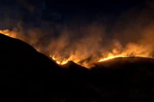
Forecasters had warned for days that Hurricane Helene was likely to cause widespread devastation. But when the powerful storm struck Florida and barreled through the eastern US last week, killing more than 180 people and taking whole communities offline, it still managed to come as a shock.
Florida’s Big Bend, where Helene made landfall, previously went decades without a hurricane strike. In the past year or so, it has now seen three. The western half of North Carolina, once held up as a haven from the worst impacts of climate change, has been paralyzed by floods.
Destructive hurricanes like Helene highlight that catastrophic impacts from storms can extend far inland
Inland communities will increasingly need to prepare for impacts from storms.
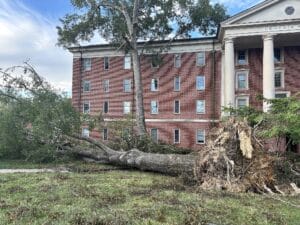
Destructive hurricanes like Helene are a stark reminder that significant and devastating impacts from many major storms are not relegated to coastal cities and communities — inland regions often face catastrophic impacts too, experts are warning.
The Category 4 hurricane made landfall on Florida’s Big Bend region Thursday night before tracking north, leaving a wake of destruction over 400 miles in the days the followed.
In February, Woodwell Climate Research Center’s new Climate Justice committee gathered for the very first time. Even through the screen, you could feel it—a buzz of anticipation, the spark of hope, as folks from across the organization came together to dream about the vision and goals ahead.
This was no ordinary meeting—it was the first step in what many hope will be a transformative journey for Woodwell Climate, guiding us toward a more just and equitable climate future. Like a handful of seeds taking root, this meeting was full of potential. Participants shared ideas and intentions that, with care and nurture, could grow into something powerful that reshapes the landscape of Woodwell Climate’s global impact.
Climate justice is indispensable to Woodwell’s work
Climate change is being felt around the world, but as its effects become more frequent and intense, the unequal impacts on different communities become more obvious. Some communities are disproportionately affected, while others benefit more from societal responses to climate change.
A salient example of this can be found in the aftermath of climate-related disasters like hurricanes or wildfires. Affluence of a community or country plays a role in shielding citizens from the worst effects of the disaster, and efforts to rebuild are often much swifter. Meanwhile, low income communities must often face forced displacement, material destruction, and cultural degradation.
This growing disparity underscores the need for research and solutions that acknowledge and work to rectify these inequities. Because climate change creates and exacerbates inequitable situations, addressing disparity must be a central consideration in both current climate research and long-term climate adaptation strategies.
Climate justice is an approach to addressing climate change that not only considers, but centers, disproportionate impacts. It integrates principles of social justice, human rights, and equity, emphasizing the interconnectedness of environmental issues with systems of oppression. By centering those most affected by climate injustice—who are also the least responsible for causing it—climate justice reframes the issue as not only scientific, technical, or financial but as a moral and justice concern. It requires us to consider not just where and how climate change is happening but also who is excluded or marginalized by the physical and social mechanisms of climate change and by any adaptation or mitigation efforts we pursue.
As an institution dedicated to using science to inform climate change policy, integrating climate justice enriches our work in five significant ways.
- First, by identifying who is disproportionately affected, our research and policy recommendations can be more targeted and effective in addressing vulnerabilities that might otherwise be overlooked.
- Second, demonstrating a commitment to equity in our work increases our credibility and broadens our support among diverse stakeholders, including members of historically marginalized communities.
- Third, understanding the social, cultural, and economic contexts in which climate impacts occur allows us to develop strategies that are not only scientifically sound but also socially relevant and adaptable.
- Fourth, policies shaped with an awareness of who is excluded or marginalized are more likely to succeed because they are grounded in the realities of those most affected.
- Lastly, by considering who is excluded or marginalized, we can address not only the symptoms but also the root causes of climate injustice, leading to more comprehensive and lasting solutions.
Nurturing a growing climate justice ecosystem
It’s essential to remember that this kind of transformative work is often slow, challenging, and asks for a commitment that stretches beyond the urgency of the moment. There’s no magic wand, no quick-fix—something we know deeply, sometimes frustratingly, from our scientific work. Real climate justice isn’t something you can cook up in isolation or rush through with a checklist. It’s born from the steady, patient work of weaving relationships, dismantling entrenched inequalities, and watering the seeds of small, consistent actions—nurtured across many hands and hearts over time, even when the growth feels almost imperceptible.
Think of it like the slow growth of trees that eventually give rise to forests—subtle, persistent, inevitable. The key is to stay rooted in purpose, grounded in the values that guide us, trusting that even the smallest efforts will accumulate into something deep, something strong, something lasting—like a mature old-growth forest, resilient through the cycles of time.
The work we’re doing as a committee is very much in its early, tender stages. It is dynamic and evolving, like the ‘pioneer stage’ of a forest’s life. Here, the groundwork is being lovingly (and with considerable effort) laid for what’s to come, like the lichens and mosses breaking down rock, slowly transforming barren ground into rich, life-giving soil. In these first steps, we are creating the conditions for future growth, for future flourishing.
As we move forward, the process becomes more complex—a kind of intermediate stage. Dandelions, grasses, the boldest and most audacious plants take root first, thanks to the quiet, persistent work of the mosses and lichens. The rest need a little more nurturing, a bit more care. Diversity begins to blossom—shrubs, small trees, and layers of life start to interweave, creating habitats for fungi, microbes, and animals. The community is expanding, deepening, finding its rhythm. Together as a committee we will expand our capacity to interweave more complex ideas and projects, allowing our work to deepen and evolve like a thriving ecosystem.
And then, like the forest maturing into its climax stage, we envision a time when the ecosystem is stable, resilient, and thriving—a rich blend of old, wise trees and vibrant new growth. A place where deep-rooted interconnectedness allows life to sustain itself, weathering disturbances with grace. As a Climate Justice Committee, we aim to create a space where renewal is constant, change is embraced, and growth is continuous—ever adaptive, ever committed to justice, and ever alive to the needs of all, as Woodwell Climate continues to work towards an equitable, healthy and sustainable world.
Pioneering climate justice work at Woodwell
Our first offering as a committee of mosses and lichens is to craft a set of actionable recommendations to help guide Woodwell Climate toward a future where our work is deeply rooted in the principles of climate justice, rich in diverse perspectives, and resilient in the face of challenges. This is our way of fostering the right environment for the seeds of future work to grow into a thriving, enduring ecosystem of ideas and actions. Our pioneer stage isn’t growing from a completely “barren substrate” however. We’re rich in resources – our science, staff, and you, our supporters reading this!
While developing these recommendations will be inherently challenging, it’s critical that we get it right together. How we reach our goals is just as important as the goals themselves, and our collaborative process should reflect principles of justice, equity and mutual support. In other words, the process itself should be a model of the world we are trying to create.
Drawing inspiration from Team Science—a collaborative approach to scientific challenges—Adrienne Maree Brown’s Emergent Strategy, which highlights the importance of cultivating relationships, trust, and community-building in collaborative work, and Dean Spade’s Mutual Aid, which emphasizes equitable distribution of roles, responsibilities, and credit in a supportive environment, we have created a team charter, establishing the principles guiding how we will work together.
The team charter aligns members on the goals we are working toward and how members will approach the work together, providing clarity and focus. It creates a shared understanding of the team’s purpose and mission and fosters a sense of ownership and commitment that makes it easier to stay focused on long-term goals. By clearly defining roles and responsibilities, the charter reduces confusion and prevents overlap, ensuring that everyone’s contributions are recognized and understood. The guidelines for equitable participation, decision-making, and conflict resolution, set forth in the charter, help build a culture where all voices are heard and respected. Principles of flexibility and continued improvement are embedded into the charter as well, allowing the team to adapt as needed.
Our hope is that this foundational work, like the pioneer stages of a forest, sets the stage for a process of ongoing growth, adaptation, and transformation that will carry Woodwell’s climate justice work into the future. As our work progresses (starting now with developing those recommendations), we’ll move through the intermediate stages of ecological succession—where new members are integrated and experimentation thrives. We’ll learn from both successes and setbacks, like our scientists testing their ideas in the field. Ultimately, we’ll cultivate a mature, stable ecosystem, where deep-rooted relationships hold the committee together.
Yet even in this stage, just as in a primary forest, dynamic change continues. A gap in the canopy lets in light, sparking fresh growth and kickstarting another round of succession. We find ourselves asking: How might we spark deep and lasting change for a just climate future? The forest teaches us that the answers lie in cycles of renewal, in allowing space for the new while honoring the stability of what’s been built.
Is methane release from the Arctic unstoppable?
Global warming has already caused the Arctic to release more climate-warming methane—but exactly how much will depend closely on the actions we take to halt climate change.
Under the Arctic ice lies an extremely carbon-rich environment. Over thousands of years, plants in the Arctic have absorbed carbon dioxide (CO2) from the air to grow, before being buried under snow and ice during the winter, becoming part of the soil. If this perennially frozen ground thaws—as it is now, as a result of climate change—ancient plants are uncovered, alongside plant-eating microbes that break them down.
This releases two main climate-warming greenhouse gases: CO2, and even more potent methane.
Continue reading on Climate Portal.
Woodwell Climate’s Government Relations team led the Center’s third annual D.C. fly-in this September, and you might say the third time was the charm.
“It was really impressive to see how we’ve built over the three years of doing the fly-in,” said Laura Uttley, Director of Government Relations. “The scale and scope of meetings, having five of 13 Congressional meetings be with Members themselves, and to have 17 Board members, senior leaders, and scientists participate—it’s just really exciting.”
Over the course of three days, the Woodwell Climate delegation tackled a range of near-term legislative priorities, such as the Natural Climate Solutions Research and Extension Act, standalone legislation that is currently being considered as part of Farm Bill negotiations and was adapted in the House version of the Farm Bill as “soil health research,” as well as longer-term policy development and relationship building.
Engagements spanned the full diversity of Woodwell Climate’s work. Meetings with leadership of the House Climate Solutions Caucus and Conservative Climate Caucus focused on the economic impacts of climate change and the need for expanded national climate services to make risk information available to all communities. A Permafrost Pathways delegation, including representatives of Alaska Native partner communities, shared a range of perspectives on rapid Arctic change with Alaska legislators and the Senate Indian Affairs Committee. One group talked with staff in the office of Rep. Paul Tonko (D-NY) of New York about carbon markets, and with Rep. Bill Keating (D-MA) and Sen. Ed Markey (D-MA) about Massachusetts-based research, including river monitoring and wetland restoration. Woodwell Climate also met with Democratic Whip Katherine Clark (D-MA) and Rep. Pete Aguilar (D-CA), Chair of the Democratic Caucus, to discuss opportunities to advance and protect climate policies, especially as leadership considers agendas for the next Congress.
Across all the sub-teams and meetings, Uttley says three big takeaways stood out:
1. Relationships matter
That Woodwell’s delegation secured thirteen Congressional meetings—five of them with Members themselves, including leadership of key committees and caucuses—is a testament to the Center’s credibility and the depth of relationships that the Government Relations team is building. A summer of high-profile Supreme Court decisions, the end of the fiscal year looming, and a tumultuous election cycle all contributed to a chaotic energy on the Hill in September, and legislators were only in session for three weeks between their summer recess and a break for election activities. Despite those pressures, Uttley says lawmakers and their staff were enthusiastic and engaged.
She attributes that to months (years, really) of relationship building grounded in a “here’s where we agree, and here’s how we can help” approach. An enormous amount of time and thought goes into crafting meeting agendas and materials that meet legislators where they are, address their needs and interests, and highlight common ground and opportunities for progress.
Consistency is also key, Uttley says. While individual Members come and go, and the political climate shifts, Woodwell Climate’s annual fly-in and growing year-round presence in Washington, D.C. are reminders that we are a reliable resource of information, and in it for the long haul.
2. Caucuses and committees are impact amplifiers
Meetings with individual legislators and/or their staff can be incredibly productive, but time is limited. Briefing an entire committee or meeting with leadership of a caucus group can be an effective way to get scientific expertise and policy priorities to many legislators at once. For example, part of the Woodwell delegation met with leadership of the bipartisan Climate Solutions Caucus (more than 60 members), staff for the House Sustainable Energy and Environment Coalition (100 Democratic members), and staff for the Conservative Climate Caucus, which has more than 80 Republican members, all interested in pragmatic climate solutions. These larger groups are also less susceptible to disruption through election cycles, which creates opportunities to work on policy agendas with a longer runway.
3. Accessible information makes a difference
Maps on the table, personal accounts of climate impacts, data tailored to a legislator’s district, and plain language science summaries were all on display during the fly-in, and Uttley says the Center’s commitment to making climate science relevant and accessible is a distinguishing feature that opens doors and builds relationships.
“To be able to find hooks and make climate science accessible for such a range of audiences on so many different topics is really impactful,” Uttley said.
Overall, Uttley said being in the room as scientists, community members, and policymakers —and seeing the energy they all came away with—left her with one overarching takeaway: Change is possible and “the Climate Science for Change motto is actually lived; it’s not just something we say.”
Thousands of fires are burning in the drought-wracked Amazon
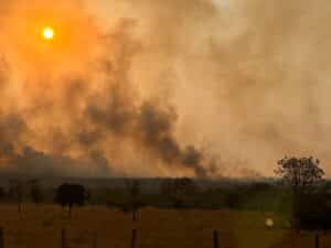
Much of Brazil is burning as tens of thousands of fires rage around the country, half of them in the Amazon rainforest. Exacerbated by a severe drought, the fires threaten one of the world’s most crucial ecosystems and are consuming the Amazon’s vast stores of carbon, sending more of the damaging greenhouse gas into the atmosphere.
2.4 million hectares (about 6 million acres) of forests, fields and pastures in the Amazon burned between June and August. There were more than 95,000 hot spots in the Amazon biome this year to Sept. 18, according to data from Brazil’s National Institute for Space Research, known as Inpe.
On Wednesday, September 25, 2024 at 10:00 a.m EDT, representatives from Woodwell Climate Research Center and IPAM Amazônia joined Governor of Pará, Brazil Helder Barbalho, for a special Climate Week event to explore the impacts of climate change on the state of Pará, and launch a new partnership to develop an in-depth climate risk assessment for the state that can inform local adaptation plans and solutions.
“Three years ago, Woodwell Climate partnered with the UK COP 26 Presidency on research that showed the lack of access to tailored, actionable climate risk information was a critical barrier to climate mitigation and resilience planning at the national and sub-national level,” said Dr. Wayne Walker, Chief Scientific Officer for Woodwell Climate Research Center. “Now, we are proud to be partnering with next year’s COP 30 host on work that provides a clear example of how to bridge this important information gap for the state of Pará.”
In 2021, Woodwell Climate and IPAM conducted an initial climate risk assessment for Belém, the capital of Pará and host of next year’s UN climate negotiations, COP30. The study found that the hottest months in the region are getting hotter, and a growing number of days per year are hitting dangerously high wet-bulb – or “feels like” – temperatures, increasing risk of severe heat stress, especially in a city where most economic activities take place outdoors. It also found that the fire season in Pará is getting longer, exposing local communities to extended periods of worsening air quality. A new, more comprehensive climate risk assessment, the initial results of which were presented during Wednesday’s event, shows that Belém is, and will continue to be, at high risk of severe flooding.
“If climate change continues on its current path, Pará will face crises on multiple fronts—with forests devastated by drought and fire, and cities facing devastating extreme heat and flooding,” said Dr. Ludmila Rattis, Assistant Scientist in Woodwell Climate’s Tropics Program. “The roots of these challenges are global and understanding that can drive urgent action to both reduce greenhouse gas emissions and begin necessary adaptation efforts.”
Through this new agreement, Woodwell Climate, IPAM Amazônia, and the Pará government will build on the findings of these assessments to analyze the climate risks facing the Pará region and co-develop effective climate solutions to address them, including identifying areas where green infrastructure could be implemented, pathways to transition to new, more sustainable economies in Pará and across the Amazon, and other mitigation and adaptation strategies.
“The quality of science to support decision-making is fundamental,” said Governor Helder Barbalho. “As the capitol [of Pará] and as the host city of COP30 next year, Belém at this moment has the opportunity for major infrastructure works that will not be the whole solution, but certainly can improve water management, sanitation management, macro-drainage infrastructure to maintain the character of a city surrounded by rivers.”
As a part of this effort, Woodwell Climate will also work with IPAM and the Pará government to develop a case study, as a part of Woodwell’s Unlocking Land-based Opportunities for Climate Solutions (UnLOCS) initiative, to investigate how to effectively scale nature-based climate solutions in Pará leveraging mechanisms like the voluntary carbon market, with the goal of dramatically reducing emissions from land use while delivering meaningful benefits to local communities, ecosystems, and economies.
“We cannot imagine that looking at the forest requires [only] public policies for the forest,” said Governor Barbalho. “We need to be able to look at the forest, but know that the impact of them will require us to act in urban centers.”
“I want to reaffirm IPAM’s commitment to this partnership that we have had with the government of Pará, the State of Pará, and the people of Pará,” said André Guimarães, Executive Director of IPAM Amazônia (Amazon Environmental Research Institute). “We have to work collectively. There is no single solution to the problems we are facing today.”
“This is an incredible opportunity to focus the world’s attention on tropical forests, on Brazil, on Pará,” said Dr. R. Max Holmes, President and CEO of Woodwell Climate Research Center. “We all understand that the Amazon is an incredibly important region, not just for Brazil and for the people that live there, but for the entire world—for all of us.”
Historic rainfall inflicts chaotic floods across four continents

Severe rains bucketed down on central Europe, Africa, Shanghai and the US Carolinas this week, underscoring the extreme ways in which climate change is altering the weather.
Different meteorological phenomena are behind the series of storms, according to climate scientists, though they agree an underlying factor for the supercharged rainfall is global warming writ large. Research has shown that hotter air is capable of carrying more moisture and is more likely to cause intense precipitation.
