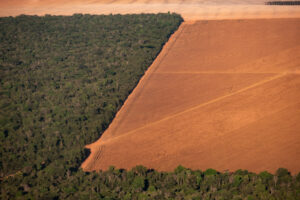
Amazon loses 10% of its vegetation in nearly four decades
Tanguro MPI Torres
June 2019
The Amazon region has lost 10% of its native vegetation, mostly tropical rainforest, in almost four decades, an area roughly the size of Texas, a new report says.
From 1985 to 2021, the deforested area surged from 490,000 square kilometers (190,000 square miles) to 1,250,000 square kilometers (482,000 square miles), unprecedented destruction in the Amazon, according to the Amazon Network of Georeferenced Socio-Environmental Information, or Raisg.
Read more on The Associated Press.
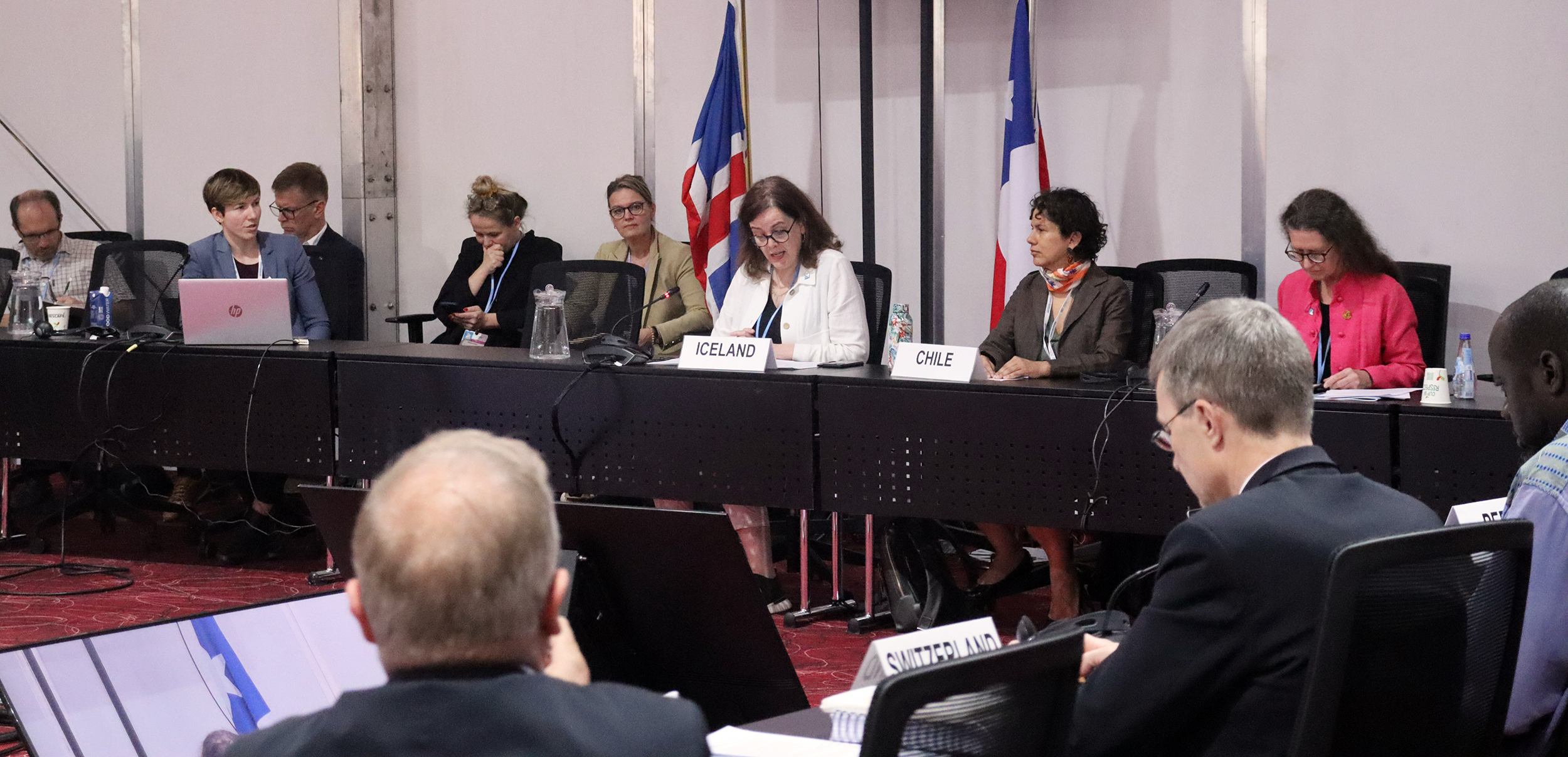
From November 6 to November 18, 2022, representatives from across the world gathered in Sharm el-Sheikh, Egypt for COP27. The annual Conference of the Parties of the United Nations Framework Convention on Climate Change (UNFCCC) has the goal of bringing together governments to accelerate and coordinate global efforts to address climate change.
Representatives from Woodwell Climate Research Center (Woodwell) attended COP27 in its entirety. Woodwell scientists with expertise in Arctic and tropical ecosystems took part in a series of panels and side events focused on the importance of accounting for permafrost thaw in global carbon budgets and pushing for the valuation and protection of tropical forests.
While the outcomes of COP27 span scales and nations, we identified some of the outcomes that are most relevant to U.S. policy.
- The U.S. signed on to the global methane pledge. Participants of the pledge agree to take voluntary actions to work to collectively reduce global methane emissions by at least 30% from 2020 levels by 2030.
- President Biden recommitted the U.S. to climate action and announced some new funding initiatives and partnerships as part of this commitment. These include $100 million for global adaptation to climate change, $150 million for disaster emergency response across Africa, and $250 million for clean energy investment support in Egypt. Notably, this is still far below the U.S. fair share for international climate finance.
- At COP27, U.S. Climate Envoy John Kerry announced the Energy Transition Accelerator, a public-private initiative to promote renewable energy projects through carbon offsets.
- The U.S. joined the European Union in signing on to a historic loss and damage deal that could potentially provide funds to support developing nations that are particularly vulnerable to climate change. While the agreement sets the stage for negotiations on developing a funding mechanism, there is no money currently pledged, there are no commitments from any countries to contribute in the future, and there are no rules in place for how the money would be distributed.
- The U.S. joined several other countries in pledging a total of $135 million in new funding for fertilizer efficiency and soil health programs with the goal of combating fertilizer shortages and addressing food insecurity.
- At COP27, U.S. Secretary of Agriculture, Tom Vilsack, highlighted the U.S. Department of Agriculture’s initiatives and investment in climate-smart forestry and agriculture and announced a new online platform for international collaboration to support countries and producers most vulnerable to global climate change.
In the realm of tropical forests, Brazil, Indonesia, and the Democratic Republic of the Congo launched a formal partnership to cooperate on forest preservation. Related to Woodwell’s work on permafrost thaw and Arctic science, Chile and Iceland launched the Ambition on Melting Ice, a coalition of governments that will focus on helping political leaders and the public better understand the impacts of snow and ice loss globally.
As countries work to address climate change globally and domestically, Woodwell is committed to supporting strong, science-backed climate policy that can be used to help inform different efforts to address global climate change.
“Talk to Jim. Jim knows everything.”
That’s what everyone told Woodwell Assistant Scientist, Dr. Jennifer Watts, when she started writing up a research plan to study soil carbon on U.S. rangelands. “And indeed, he does,” Dr. Watts says. “He knows everything about the region, about grazing management, species management, anything having to do with land management on these ranches.”
With his felt Stetson, dusty jeans, and perennial tan, ranch manager Jim Howell looks a bit like the kind of cowboy Hollywood might dream up. And in a way he is—despite looking at home on the range, Howell grew up in Southern California. But he spent his summers out in Colorado’s Cimarron mountains, working on his grandfather’s cattle ranch.
Those summers were Howell’s introduction to the idea that the way livestock are managed can change their impact on the land—a thread that would pull him through a college degree in animal production, towards a career “knowing everything” about holistic ranch management. He was first clued into this concept while walking the fence line separating his family’s property from a patch of public land being used to graze sheep.
“I noticed there were lots of very healthy, perennial, bunch grasses on the sheep side, while our side of the fence had degraded to mostly silver sagebrush, Kentucky bluegrass, and dandelions,” says Howell. “And I just didn’t understand why the differences were so stark.”
Howell’s cattle were stocked continuously on the land, low in number but able to graze year round, while the sheep grazing permit required rotation. There might be a great flock of sheep up there one day and nothing but grass for the remainder of the year. That difference, it turned out, dramatically altered the kinds of plants that could flourish on the land.
“I became aware then that the way that we’d been managing our cows in our country up there was leading to its slow, long-term, ecological degradation. And I didn’t know what to do about it,” says Howell.
The grazer makes the range
There have always been animals grazing the American West—before colonizers, even before native peoples. On the Great Plains there were bison; in the mountains and high altitude deserts of Southwestern Colorado, it was bighorn sheep and pronghorn antelope, as well as elk and mule deer. All three are rare sights now, with populations decimated by overhunting and habitat degradation.
Now, if you see any animal grazing on these ranges, it’ll probably be cattle.
Despite displacing native species, cows can still fill a natural niche in the rangeland ecosystem. Antelope, bison, sheep, and cows all belong to a group of animals called ruminants—animals that can digest grass. Many grasslands have co-evolved with ruminant species; their roaming feasts influence plant growth the same way pruning might affect the shape of a tree. Occasional shearing by a hungry cow stimulates new grass growth. It also creates a more competitive environment that supports a diverse array of plant species.
Grazing also plays a part in cycling nutrients and storing carbon in the soil. In a frequently dry climate like this one, digestion breaks down plant matter much faster than it would decay in the environment. Manure fertilizes new plant growth and returns carbon to the soil. Let this process continue unencumbered for a couple hundred thousand years, and you can build up a valuable carbon sink. And as long as the number of cattle isn’t rising, the oft-cited methane emissions from cow burps are minimal and cycled back down into the plants that grow up after grazing.
Since settlers arrived, however, the land has been put through centuries of abuse. Public lands were, for a long time, left open to unregulated grazing. Many rangelands have been over-stocked and grazed too frequently in order to make a profit and meet growing global beef demand. Land has been ecologically degraded, valuable topsoil was lost, and carbon stores declined as a result.
Let the cow do the work
It would be easy to blame cows for this. But really, they’re not behaving much differently than pronghorn or bison would. They eat what’s in front of them. And they eat the tastier plants first. Howell likens it to a salad bar.
“If you go into a salad bar and there’s some lettuce that has been sitting there for three months, and some of it that’s just been replaced that morning, you take the new stuff. So that’s exactly what the cow does,” Howell says. “If she’s not made to move anywhere new, she’s just going to keep coming back and grazing the regrowth of the good stuff as long as it’s there.”
Pretty soon, perennial grass species, important for their deep roots that help prevent erosion and store carbon and water longer, are grazed into nothing. All that’s left are the sagebrush, dandelions, and other less desirable plants that Howell noticed dotting his family ranch.
“So the whole thing is about how the cows are managed, it’s not the cow itself that is a problem,” says Howell.
But if bad management can degrade the land, then good management should be able to restore it. While studying animal science in college, Howell encountered the concepts of “holistic management”, a term that began to decode this relationship between management practices and the health of the land. Controversial at its introduction a half century ago, holistic ranching has been gaining traction, and Howell and his ranch management company, Grasslands LLC, have helped urge its uptake.
The core principle is to make management decisions that restore lands and keep cattle in balance with the rest of the ecosystem—helping them fill the niche of the ancient grazers. This comes with a host of co-benefits, including water retention and higher plant productivity, that actually end up improving economic profitability for ranches in the long run. Simple adjustments, like lengthening the time between grazing a pasture again and wintering cows on native ranges instead of hay, can turn cattle from an ecosystem destroyer to an ecosystem helper.
“The trick is to let the cows do all the hard work,” says Howell.
Carbon modeling: The rancher’s secret weapon
Dr. Watts and Woodwell Senior Scientist Dr. Jonathan Sanderman, along with Dr. Megan Machmuller of Colorado State University, are interested in quantifying those co-benefits. Especially carbon storage.
“In the western US on our rangelands, just like in our croplands, we can change how we manage in a way that potentially could become a natural climate solution,” says Dr. Watts. “One where we’re bringing in more carbon than we’re emitting and we’re creating ecosystems that not only are beneficial for carbon sequestration, but also have more biodiversity, offer more habitat for wildlife, and more water conservation.”
In order to prove that value however, scientists need a baseline understanding of how much carbon is currently stored across both traditionally-and holistically-managed rangelands. It’s hard to get an estimate for such a large area (roughly 30% of the U.S. is covered with rangelands), so they are using a remote sensing model, which they verify with strategic on-the-ground sampling.
Howell’s work also created the perfect conditions for the research team to study the long term carbon benefits of altered ranching practices, which is a tricky thing to test empirically. Ranchers must constantly adjust their management techniques to stay profitable.
“In a classical research setting, you try to control all the variables but one, but in real life that’s not what happens,” says Howell. “Nothing is controlled. Day to day, you have to adapt to constantly changing conditions.”
But the ranches Howell’s company works with make those day-to-day decisions based on the principles of holistic management, so tracking carbon on those ranches over time offers the opportunity to generate baseline data on how they differ from more traditionally managed ones.
Howell also brought the expertise of a life spent on the range. He can identify just about any plant growing in the pasture, tell you which are native, which are invasive, and which used to be the preferred food of prehistoric ground sloths. His eye is trained to see diversity even in martian-esque deserts and read the history of the land in the structure of the soil. In May of 2022, Howell guided Drs. Sanderman, Watts, and Machmuller and their teams on a sample collection trip through Southwest Colorado and Utah. The researchers took soil cores, plant samples, moisture and temperature readings, and analyzed carbon fluxing in and out of the pasture.
The ultimate goal is to create a rangeland carbon management tool that will make the soil carbon data model accessible directly to ranch managers. Dr. Watts hopes having that data in hand will enable more ranchers to make management decisions with climate in mind. Dr. Sanderman also notes that it could be useful in eventually helping ranchers get paid for sustainable practices.
“Rangelands haven’t been included in voluntary carbon credit markets like cropping systems have,” says Dr. Sanderman. “Monitoring is a big problem because there’s so much land—How do you keep track of all that? That’s what our tool will be able to offer.”
Growing a resilient ranch
There are limits to what grazing can accomplish, though. The lands out west aren’t suitable for large-scale cropping, being too dry or too mountainous, which makes them perfect for cattle. But when the animals take up space on land that would otherwise be used to produce crops—or worse, penned into feedlots—their benefits are compromised. Howell also notes that some grazing lands are already as saturated with carbon as they can be. And there remains the fact that ranching will get more complicated as the climate changes.
At the Valdez ranch in Delta, Colorado, Dr. Sanderman and research assistant Colleen Smith unfold a collapsible table in a field of cracking mud, dotted with the brittle stick skeletons of dead grass. Nearby, Dr. Machmuller is assisting Howell in extracting a long metal cylinder from the ground. It was plunged into the soil by a hydraulic corer attached to a pickup truck that’s idling in the field. Howell and Dr. Machmuller lay it out horizontally on the table and slide out the soil core—a 50 centimeter long history of the land beneath their feet.
Howell breaks open a section of the core with his fingers, revealing clusters of white crystals. This is a pasture that has been abused; over-irrigation by previous owners brought salts to the surface. Now nothing will grow here and wind gusts threaten to blow away loose topsoil. It’s a sacrifice zone. The current owners are considering installing solar panels instead.
Water is a big issue for ranchers and it’s threatening to get bigger. The region is constantly dipping in and out of severe drought, and in a place that depends heavily on winter snows for its groundwater and rivers, a warmer, drier climate is a threat.
Agriculture will depend more on irrigation as the climate warms and precipitation patterns change. But this empty pasture is proof that it’s not always a viable solution, and will become less so as climate change advances.
It enforces the urgency of the work Howell and team are doing. The faster we can draw carbon out of the atmosphere, the more successful these ranches are likely to be in the long term. The better managed the ranch, the more resilient it will be in the face of tough conditions.
In the end, Dr. Watts says, the outcome rests in the hands of ranch managers—people like Howell.
“Land managers are the ones that ultimately are going to make or break this country.”
COP27 long on pledges, short on funds for forests — Congo Basin at risk
The first big news of the COP27 climate conference was a forest promise: UK Prime Minister Rishi Sunak announced a 26-nation partnership to conserve woodland ecosystems as “one of the best ways of getting us back on track to 1.5 degrees” of warming.
This Forest and Climate Leaders Partnership is meant to martial efforts to halt and reverse forest loss and land degradation by 2030, as 145 countries pledged in the Glasgow forests declaration at COP26.
But one year on, countries are lagging behind the pace needed to reach the Glasgow goal, experts said. Most worryingly, the funding pledged to fight deforestation is far from enough and has often failed to arrive.
The 30DayMapChallenge is a social media based mapmaking challenge open to everyone. Each November, participants from all over the world create a new and original map for 30 days, where each day has a unique theme. In 2022, Woodwell Climate Research Center participated as an organization, including as much of our work as possible while still adhering to the map categories.
Soil moisture impacts the tundra carbon balance in a changing climate
There is growing recognition that soil moisture plays a crucial role in regulating the response of tundra carbon cycling to climate warming.
Arctic tundra is Earth’s coldest terrestrial biome after glaciers, yet this far northern biome is warming three to four times faster than the global average (Rantanen et al., 2022). Importantly, the Arctic tundra biome stores ~160 Pg C in the top 1 m of permafrost soils (Loranty et al., 2016), which is equivalent to ~17 years of humanity’s fossil fuel emissions at current levels. Continued warming could cause a significant portion of this carbon to be released into the atmosphere over the coming century (Schuur et al., 2022), therefore it is crucial to better understand the carbon balance of tundra ecosystems including climate change impacts.
Read more in Global Change Biology.
