| District | 2000–2020 | 2040–2060 | 2070–2090 |
| Addis Ketema | 22.80 | 24.32 | 25.90 |
| Akaky Kaliti | 25.57 | 27.07 | 28.64 |
| Arada | 22.80 | 24.32 | 25.90 |
| Bole | 24.20 | 25.71 | 27.29 |
| Gullele | 22.40 | 23.92 | 25.50 |
| Kirkos | 23.47 | 24.98 | 26.56 |
| Kolfe Keranio | 23.84 | 25.34 | 26.92 |
| Lideta | 23.44 | 24.95 | 26.52 |
| Nifas Silk-Lafto | 24.70 | 26.21 | 27.78 |
| Yeka | 22.94 | 24.45 | 26.03 |
Climate risk assessment: Addis Ababa, Ethiopia
Background
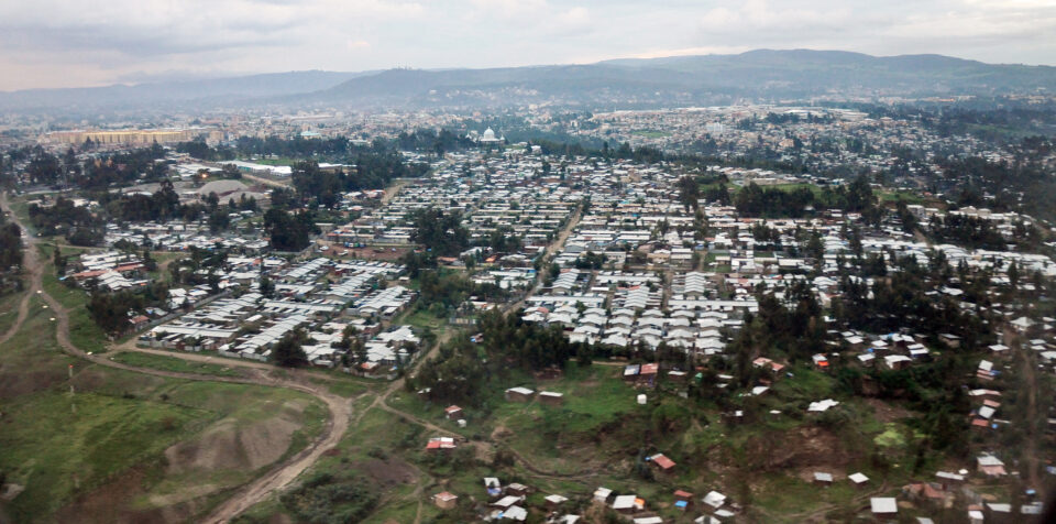
Addis Ababa is Ethiopia’s capital and largest city. Today’s metro population of 5.3 million people—already more than twice its 2000 value of 2.3 million—is projected to reach almost 9 million by 2035.1 This is in line with broader global trends whereby half of the world’s population growth through 2050 will occur in Africa. With only 21% of its population in urbanized areas, Ethiopia is in the early stages of a rural-to-urban transformation and is one of the least urbanized countries globally.2, 3 Addis, however, has a long history of in-migration—approximately 40% of Addis inhabitants were born outside the city.4 This trend is expected to continue. Conflict, environmental degradation, and climate change will continue to displace people throughout Ethiopia and contribute to increased urbanization in all Ethiopian cities and towns, especially Addis.5
Informal settlements in Addis are the prime destination for most migrants (both internal and international). These areas are characterized by infrastructure that is either non-existent or severely lacking, and face the twin challenges of worsening climate change and poor urban environmental policy. Addis’ mountainous landscape has already been degraded from deforestation and soil erosion from the ongoing proliferation of informal settlements. Such unlicensed construction is typically associated with poor drainage systems, improper waste disposal, and a loss of green spaces—further exacerbating Addis’ vulnerability to shocks and stressors.6
In particular, such rapid urbanization and expansion of informal settlements exacerbate the city’s vulnerability to flooding.7 The decline in green spaces alone is estimated to contribute to 40% of flooding and landslides in Addis. Public health is also negatively impacted by the footprint of informal settlements. An estimated 40% of vegetables supplied in the city are irrigated with wastewater drawn from polluted rivers.8 Finally, the pressures of in-migration are additional to existing climate change impacts. Already in today’s climate,9 Addis is particularly vulnerable to drought, heat waves, and flooding—67% of the population in Addis lives in flood prone areas.10 Addressing social and climate pressures in a quickly urbanizing metropolitan area is a frontier challenge for Ethiopia and the Addis city government.
While there is broad consensus that improvements to the climate resiliency of Addis are necessary and urgent, the governance system suffers from severe limitations that impede these improvements.11 As a result, climate change planning is not yet fully integrated into general urban planning activities. A recent survey of planning and administrative professionals points to several implementation issues. Almost half of respondents did not believe that Ethiopia’s urban spatial planning policy documents successfully mainstreamed resilience principles, with 35% of respondents ascribing that failure to poor political commitment and lack of communication between federal, regional, and local levels.12
This is supported by past trends whereby climate change adaptation is implemented at the national level, not locally,13 and by the five local to federal agencies with planning authority for Addis.14,15 Informal construction practices that severely limit the enforceability of land protections and building standards are another key issue. There is some degree of public skepticism and distrust towards official planning efforts. In the recent past, that dissatisfaction culminated in public unrest, which led to abandonment of the Integrated Regional Development Plan.
To address this history of governance challenges, the Addis Ababa Climate Action Plan16 highlights a need for improved coordination between city and federal authorities and a need for additional training to increase the professional and technical capacity of city staff. This same planning document also describes existing priorities. The top climate concern is drought, which will affect health, hydroelectric energy production, and urban agriculture. Flooding is a major concern, particularly in the sub-cities of Kolfe Keranio, Nifas Silk-Lafto, and Addis Ketema. Landslides, driven not only by extreme rainfall but also poor urban water management and the loss of green space, will affect Gullele and Yeka in particular. Additional concerns are heat waves, extreme day and night-time temperatures, and increasingly heavy and variable rainstorms.
While the challenges in Addis are significant, similar environmental, climate, and urban planning concerns are shared by many African cities. These center on governance capacity and land use enforcement; urban stormwater management, riverine flooding, sewage management, and water provisioning; climate-change- and urban-heat-island-induced high temperatures; and contamination of air and water resources. Addis, like most African primary cities, will be better able to adapt to climate change with improved land use management and building standards, upgraded urban drainage and stormwater management infrastructure, and more urban green infrastructure. City climate adaptation plans must also incorporate the needs and experiences of migrants and those living in informal settlements, who are both particularly vulnerable to climate change and also play a role in exacerbating environmental challenges in cities.
Results
To illustrate the links between climate change, land and water management, and vulnerable populations in Addis, we examine projected changes in extreme heat, drought, and flooding. Our analysis explores how these changes have affected—and will continue to impact—informal settlements, land and water use, and development plans within the city.
Social Vulnerability
Informal Settlement Maps
Approximately 80% of Addis Ababa’s population live in informal settlements.17 These settlements are known as “Chereka Bet,” and are home to the city’s most vulnerable residents, including migrants and refugees. Prior attempts have been made to map these informal settlements,18 but due to the lack of comprehensive and current maps of informal settlements in Addis, bespoke maps were developed for this study.19
Vulnerability Analysis
An analysis of social vulnerability considered three variables: wealth, access to communication devices, and years of education.20 Social vulnerability in Addis remains low relative to the rest of the country, likely because the urban setting is where communications, education, and wealth tend to be concentrated. However, the city is not without pockets of high vulnerability, often where informal settlements, a lack of resources, and exposure to climate hazards coincide.
Climate and Environmental Vulnerability
Extreme Heat
Although the entire city of Addis will experience warming in the future, some districts are more vulnerable to extreme heat than others. In the southern end of the city, Akaky Kaliti, Bole, and Nifas Silk-Lafto are already experiencing some of the hottest maximum temperatures across the city during the warm season (March–May), and will remain more vulnerable to extreme heat in the future as well (Table 1).
Table 1. Average warm season (March–May) maximum temperatures for 2000–2020, 2040–2060, and 2070–2090 by region in Addis Ababa (°C). Data Source: CMIP6 data, downscaled using the CHELSA methodology.21,22
Extreme daily maximum temperatures, those that occur on average every 1-in-20 days, or the hottest 5% (18 days) of the year, are expected to increase by 1.7°C between 2000–2020 and 2040–2060 for Addis (Figure 1a). For the warm-season months of March, April, and May, an increase of 1.8°C is expected (Figure 1b). This means that the 18th-hottest day of the year will be, on average, around 1.8°C warmer in the future compared to the recent past. Daily maximum temperatures throughout the year are also set to increase; this can be seen in the rightward shift of the peak of the distribution curves between 2000–2020 and 2040–2060.
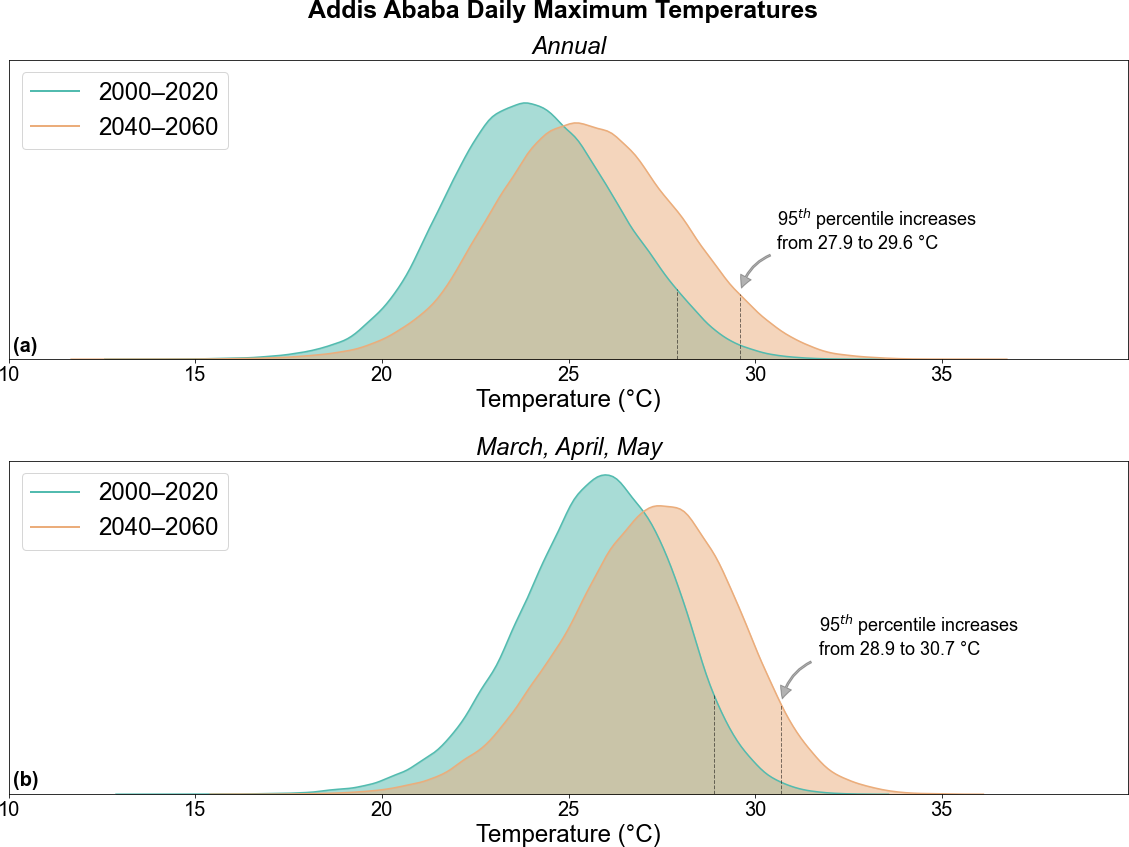
Figure 1: Daily Maximum Temperature Distributions for Addis. (a) Annual. (b) March, April, and May (warmest season). Data source: CMIP6 data, bias-adjusted and downscaled using ISIMIP3BASD v2.5 methodology.23,24
The city of Addis has made major strides in combating malaria in recent years, and has a low incidence rate—even designated as “malaria-free”25—relative to the rest of the country (Figure 2). However, climate change has the potential to expand the mosquito habitation zone and, consequently, spread of mosquito-borne diseases such as malaria.26 Despite its projected warming, Addis will be somewhat immune from the climate-change-driven habitat expansion of mosquitos given its arid environment at high elevation, but malaria will remain an important health consideration moving forward.
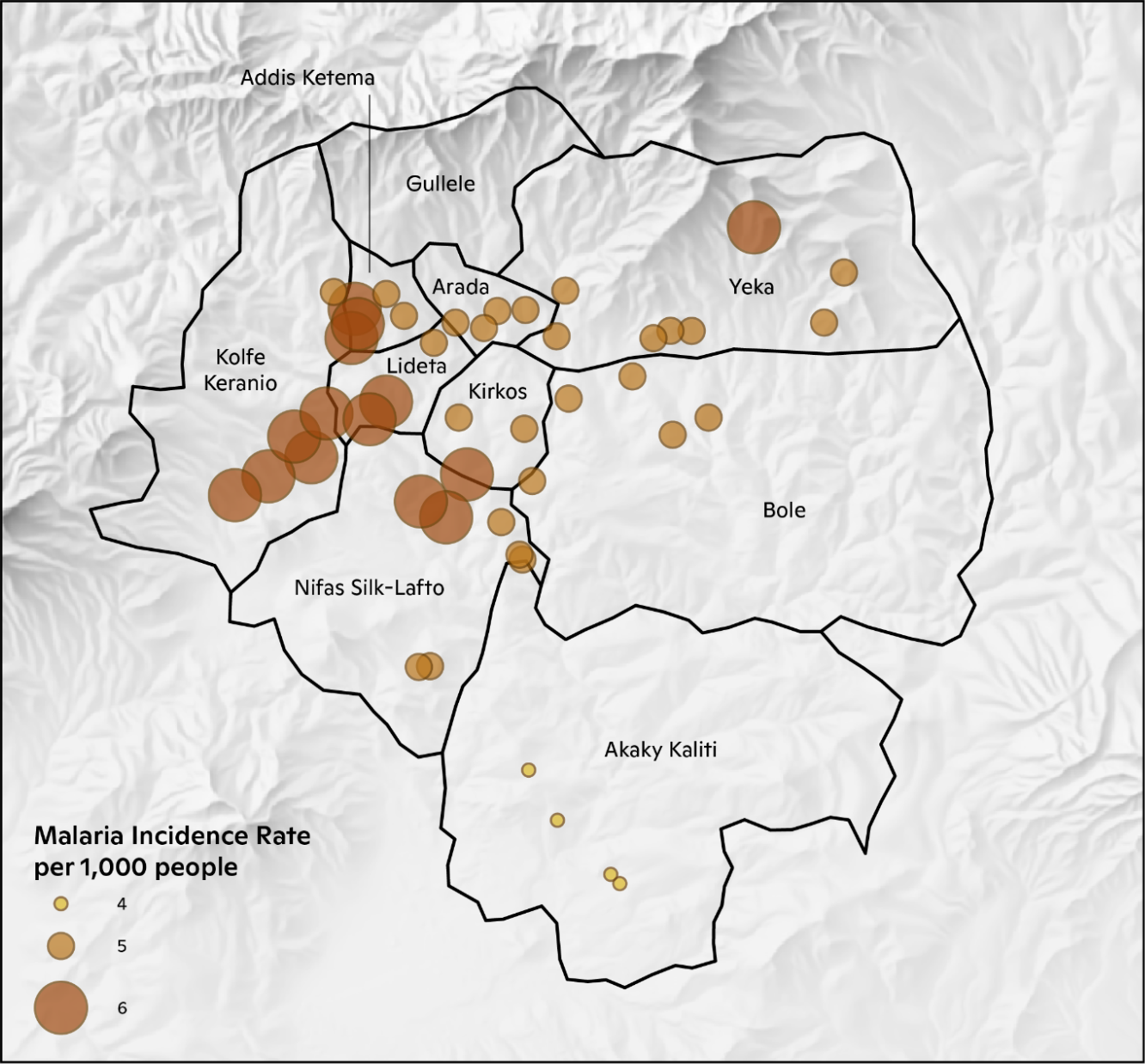
Figure 2: Observed Malaria Incidence Rates in Addis Ababa.27
Drought
The frequency of extreme drought in Addis is expected to increase between 2000–2020 and 2040–2060. Drought stress is based on the Palmer Drought Severity Index (PDSI), a globally recognized standard of drought assessment.28 In the past two decades, Addis experienced extreme drought, on average, around three months per year. In 2040–2060, Addis is projected to experience an annual average additional 1.6 months of extreme drought, an increase of 53%.
Land Use and Flooding
Flooding is a major environmental challenge in Addis Ababa. Flood risk is magnified by city construction around three large rivers, a weak sewage system, frequent construction excavations that exacerbate flood and landscape risk, and a poor drainage system. The number of people exposed to flood risk in Addis is increasing and water-related challenges extend beyond flooding to include procurement, treatment, and management of polluting solid and liquid wastes. Climate change will increase water-related challenges by driving variable surface river flow and groundwater replenishment, increased evaporation, increased water demand, declining water quality and associated health problems, and more.
Too much rainfall, particularly if it occurs within a short period of time in an urban area, can lead to flooding. This poses risks in cities, as urban environments are much less equipped to deal with high precipitation. The central areas of Addis Ababa, which contain the greatest density of impervious surfaces that contribute to flood risk, have a concentration of relatively high precipitation averages. Some of the greatest flood risk occurs in the southern half of the city where the slope is relatively flatter than in the northern parts of the city (Figure 3). The Nifas Silk-Lafto region of the city has experienced considerable development in the floodplain that has exacerbated vulnerability.
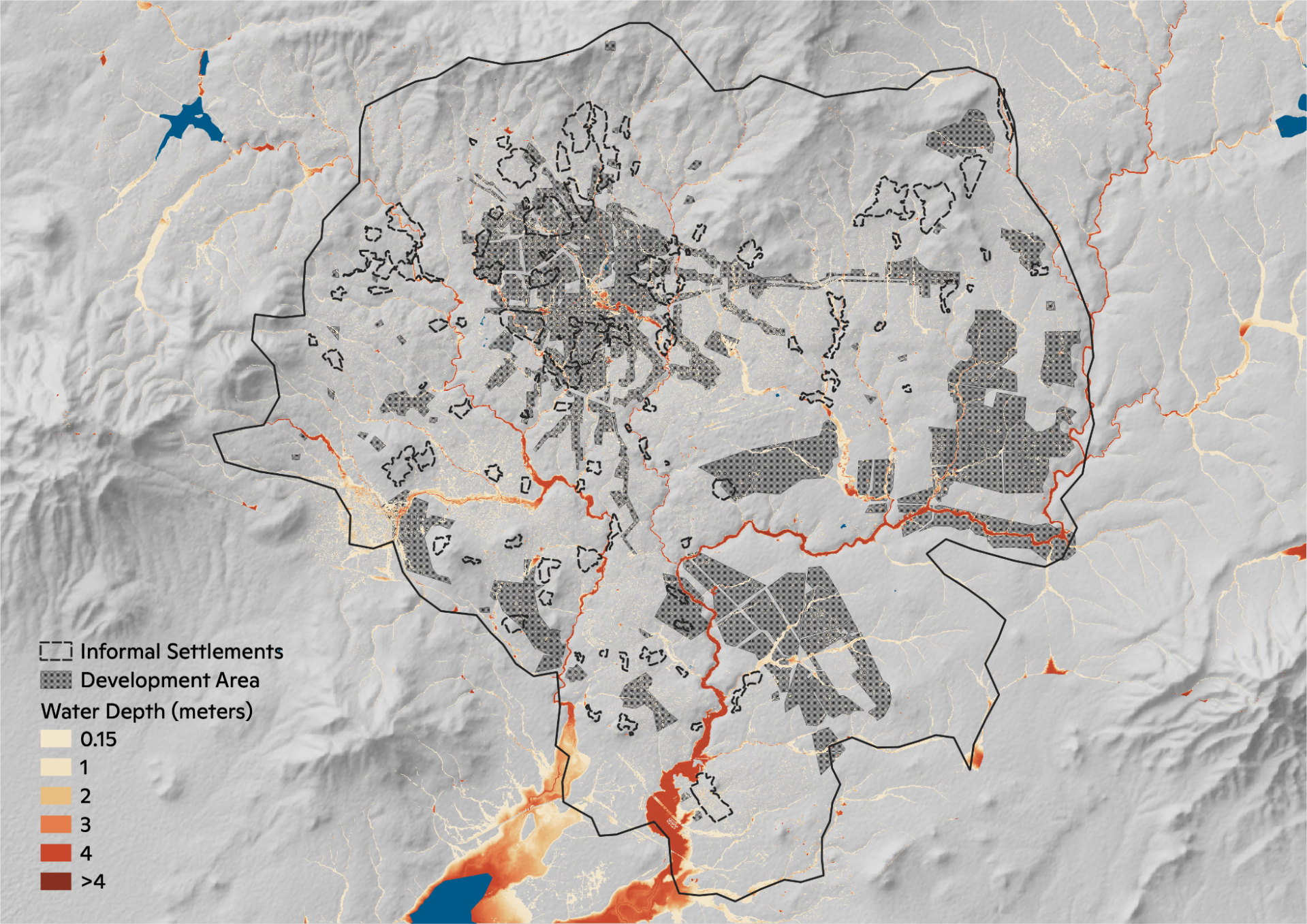
Figure 3: Present-day flood depths for the 1-in-100 year flood event. Informal settlements and future development areas are overlaid.
Table 2. Number of buildings impacted by floodwaters.
| Present | 2050 | 2080 | |
| Informal Settlements (Total: 89,960) |
9,436 (10.1%) | 10,758 (12.0%) | 11,514 (12.8%) |
| Non-Informal Settlements (Total: 584,822) |
55,616 (9.5%) | 62,393 (10.7%) | 65,760 (11.2%) |
An analysis on whether informal settlements face a disproportionate level of flood risk compared to the rest of Addis Ababa was conducted by calculating the number of buildings that would be impacted by floodwaters during the 100-year flood event. Because the buildings dataset represents present-day development, these results are underestimates of future building exposure given that construction will only continue as the population in Addis Ababa increases. The results of the analysis (Table 2) show that informal settlements face a higher level of risk based on the metric of buildings impacted. The disparity also grows through the 21st century: presently the percentage difference is 0.6%, and this will grow to 1.3% by 2050, and 1.6% by 2080. We conclude that informal settlement communities will likely face greater disproportionate flood risk through the 21st century. Moreover, floods have the propensity to disproportionately impact under-resourced communities due to a lack of insurance and the resources to rebuild in their aftermath.
Green Space
Loss of green spaces in Addis Ababa due to current development practices and changing urban land use is exacerbating landslides and flooding within the city. Figure 4 shows the change in urban land cover from 2000 to 2020 with a clear trend in expansion. Preservation of green spaces, then, is an important resilience strategy for the city. Two major barriers to the preservation of green spaces in Addis Ababa are the lack of adherence to plans and institutional structures that impede coordination and collaboration among city agencies and those across municipal and federal bounds.
Much of the new development in Addis Ababa is replacing cropland areas. Figure 5 shows that many areas where urban space has taken hold from 2000 to 2020 were previously croplands. Furthermore, some development has occurred in the existing floodplain. Ten percent of the newly built-up area within the last decade has been in the present day 100-year floodplain. As Addis Ababa continues to grow, it is expected that development will progress and that there will be further encroachments into the floodplain. As a result, flood risk to both people and structures will only grow in the future in the face of climate change.
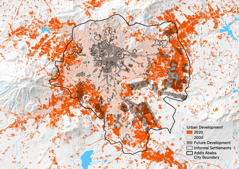
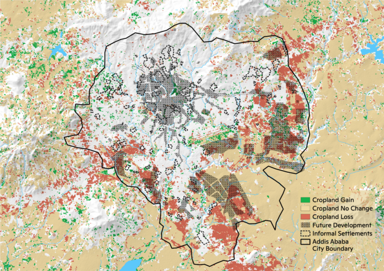
Figure 4: Change in urban land cover in Addis Ababa from 2000 to 2020.29
Figure 5: Cropland land cover change from 2003 to 2019 in Addis Ababa.27
Housing
Rapid urban growth is exacerbating environmental challenges in Addis Ababa but is also a product of climate change itself. More severe droughts in Ethiopia are making traditional farming unsustainable and causing farmers to move to the city in search of different livelihoods, thus driving urban expansion. Within the city of Addis Ababa, flooding is a major environmental challenge. Informal settlement growth along riverbanks is decreasing flood resilience by reducing the riverbanks’ capacity to buffer storm surges and leading to contamination of the river system from household waste.
Waste Management
Solid waste management is a continuing concern for Addis Ababa. Solid waste is often left in residential neighborhoods or collected but not properly treated. These issues pose threats to human health but also can exacerbate city flooding and environmental concerns as unmanaged waste clogs natural and constructed drainage infrastructure. All resilience plans for Addis Ababa aim to increase the quantity of recycled and composted goods.
Conclusions and Policy Recommendations
To address impending climate risks—especially to Addis Ababa’s most vulnerable communities—appropriate policy responses and actions can increase the city’s climate resilience. Specific recommendations include:
- Need for effective land management. The city’s planners understand the greater need for the incorporation of climate and resilience concerns—including the use of green space for flood control and heat mitigation—into land-use planning. We recommend that green space regulations are better clarified and better enforced, to enhance effective land management and green space preservation.
- Need for climate-resilient housing. Although the extent to which the City has developed housing is laudable, the location of these projects on wetlands and having limited transportation access is less than ideal. Housing development policy interventions such as the consideration of flood risks, the implementation of resilient construction practices, and the prioritization of urban mobility and transportation access would improve Addis Ababa’s climate resilience.
- Need for improved water management. Water management will continue to be heavily affected by land use enforcement and green space protection processes. Furthermore, those in informal settlements along riverbanks face the catch-22 of lacking access to running water (for drinking and sanitation) and are therefore dependent on the rivers they are forced to pollute. Our flood risk mapping demonstrated how projected flooding will adversely impact the city’s most vulnerable residents in informal settlements. An integrated water management plan may be the best way to address the multiple water-related challenges in Addis Ababa and their associated equity concerns.
- Need for greater public trust and transparency. Government plans can earn greater public trust through transparency and continuous stakeholder consultation and engagements. Despite its robust plan of urban land use and implementation practices, Addis Ababa’s Draft Structural Plan—which did not directly address displaced residents’ needs and interests and instead emphasized the development of luxury hotels, playgrounds, and golf courses—faced resistance from the public, and the current City administration walked away from the plan. Moving away from top-down models of governance and regulation and including a greater awareness of local dynamics would aid equitable climate resilience efforts. However, issues including bureaucratic red tape, some degree of corruption, lack of coordination, and institutional misalignment persist.
- Need for a responsible city agency. Although Addis Ababa has its Resilient Project Office, an effective response to the depth and breadth of climate impacts necessitates the existence of a robust, agile, and independent agency. Accountability is needed and a designated agency should be empowered to prioritize public interests and to tackle government challenges in order to effectively plan and implement climate resilience policy.
SUGGESTED CITATION
Dusseau, D., Gassert, K., Hollander, J., Jacobsen, K., Naegele, A., Schwalm, C., Williams, A., Yimere, A. (2023). Climate Risk Assessment: Addis Ababa, Ethiopia. https://woodwellclimate.org/assessments/addis_ababa