Cartographer Greg Fiske selected to create mural at Mountainfilm
Fiske’s “Cartographies of Arctic Change” shows the beautiful side of climate data
Fiske’s mural being erected in downtown Telluride.
photo by Stash Wislocki
Each year at the Mountainfilm documentary film festival a mural is erected on a coffee shop in downtown Telluride, Colorado—a mountain mining town turned world-class winter sports destination. The festival showcases films with thought-provoking themes including environmental justice, Indigenous sovereignty, racial equity, and our collective responsibility to care for the natural world. These murals carry those themes year-round, becoming an integral part of Telluride’s main avenue and vibrant art culture. Past murals have been commissioned from artists including Shepard Fairey and Banksy.
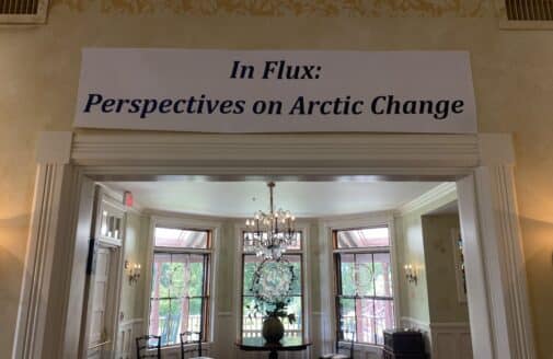
This year, Woodwell’s lead cartographer Greg Fiske was selected to display his maps as art for the mural wall. The resulting piece, “Cartographies of Arctic Change,” will remain in place until next spring, and shows the rapidly changing Arctic landscape as seen by Fiske during the process of turning satellite imagery into data used by the Center’s climate scientists. Here, Fiske talks about his process and thinking behind the creation of this mural:
SR: How did this opportunity come about?
GF: It kind of came out of nowhere. I certainly wasn’t expecting it when they said, “we think your stuff would look great on this wall. What do you think?” And I said sure!
Of course, I’ve never created a map this size (26.5 by 36 feet), so I was eager to experiment. We had to go back and forth about which of the maps would best suit the space, yet also tell a story that leads viewers to our science here at Woodwell.
SR: How did you decide on the final image?
GF: I was told that whatever you put on the wall tends to influence the feeling that you get while you’re sitting there, having your coffee. [The shop owners] said that they made a mistake one year putting up an image of something cold like an iceberg, and it kind of made the whole place feel cold and dreary. So when we selected the maps, we had to make sure that they didn’t make people feel awkward while sitting there enjoying the outdoor space.
We came up with the idea of multiple maps in strips instead of one big map to be able to have each map show something different, but could all have a single theme and tell a story.
SR: What is that story?
GF: “Cartographies of Arctic Change”—it’s what we look at on a regular basis within our geospatial analyses, modeling, and science here at Woodwell that indicates rapid change in the Arctic.
Each one of these slices in the mural, in addition to being beautiful art, are also actually the data that goes into the models that drive Woodwell’s Arctic science.
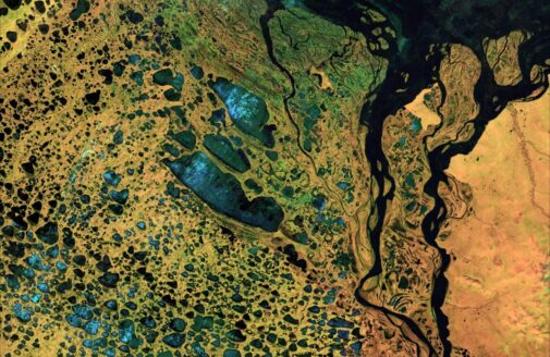
The Arctic is one of the fastest changing landscapes on the planet—melting ice, thawing ground, lakes forming or draining, less snow and more fires—and you get a unique view of those changes when you spend so much time looking at geospatial data and satellite imagery.
I’m one of the people who pull in this raw data and prepare it for others who may be creating models or mapping some element of a landscape. I look at this data and make sure it’s the right format, quality, and resolution to satisfy the needs of models, but in doing so, there are many cases where I’m like, “Wow, this is really beautiful. Other folks should see the data at this stage, instead of just the final product.” So some of those images are what ended up in the mural. I hope it can give the many viewers who will see it a new perspective on the impacts climate change is having on one of the most beautiful regions of the world.
“Cartographies of Arctic Change”
mural by Greg Fiske
SR: What does it mean to you to have been selected to showcase that beauty through this mural?
GF: Of course it’s an honor. It’s interesting to think about something that I’ve seen so many times at screen size or social media size now being amplified to building size. I’m super thankful to the folks at Mountainfilm and Telco for displaying our work. I’ve never seen any of my maps in mural format and I won’t actually know how it’ll look until I get to Telluride and see it in person. I’m super excited!