Digging into rangeland soil carbon storage with Woodwell’s scientists
A research trip to southwest Colorado collected data that will help rangeland managers track carbon captured in their soils
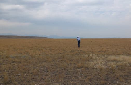
Dr. Yushu Xia and Haydée Hernández-Yáñez sampling vegetation while a carbon flux chamber operates in the foreground.
photo by Sarah Ruiz
It’s a windy morning in May and the Valdez ranch in Delta County, Colorado is alive with the sounds of lowing cattle, chattering sparrows, and the whirrs and clanks of scientific equipment. This particular field is not being grazed at the moment, so Woodwell’s soil carbon team has free rein over the rows of alfalfa and sweetgrass.
In collaboration with Dr. Megan Machmuller at Colorado State University, assistant scientist Dr. Jennifer Watts and senior scientist Dr. Jon Sanderman have brought their teams here to collect field observations that will help inform a comprehensive model of carbon storage on rangelands across the United States. Grazing lands have the potential to be a valuable carbon sink, provided the livestock on them are being sustainably managed, but the true magnitude of that value is not yet well understood. This expedition, supported by Conscience Bay Research and Western States Ranches, will help develop a regional model of the way carbon moves through rangelands and deepen our understanding of the role they play as a natural climate solution.
Ensuring the model’s accuracy requires the team to collect an array of field data from different ranch types—from irrigated and planted pasture, to the natural vegetation of high mountain and desert grazing lands. Here’s how climate scientists study carbon in the field:
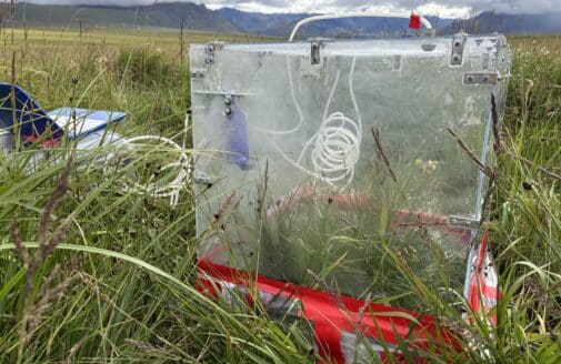
Carbon flux: What’s moving in and out of the atmosphere?
Dr. Watts and Noomah take a carbon flux measurement using a homemade flux chamber.
photo by Sarah Ruiz
Soil carbon storage begins where plants interact with the air. As they grow, plants draw carbon out of the atmosphere through photosynthesis. When they decay, microbes in the soil digest plant matter and breathe carbon dioxide and methane back out. Measuring the difference between these two processes gives us “net ecosystem flux”—a measure of whether a patch of land is sequestering or emitting carbon overall.
Measuring carbon flux requires a specially made chamber. Dr. Watts and Seasonal Field Technician Jonas Noomah employed a plexiglass contraption that Noomah constructed himself. The chamber is placed over a patch of ground, connected by clear tubes to a machine that can analyze the volume of CO2 within the cube. A handheld fan dangles inside the box to keep the air circulating. The transparent plexiglass allows photosynthesis to continue unhindered. After a few minutes, the box is covered to block out the light and the analysis is run again to capture emissions without the photosynthesis component. The numbers can be compared to assess the rate and overall carbon sink or source status of flux within the ecosystem.
(audio) Noomah and Dr. Watts, taking measurements using the flux chamber, explain the importance of such data in the overall carbon model.
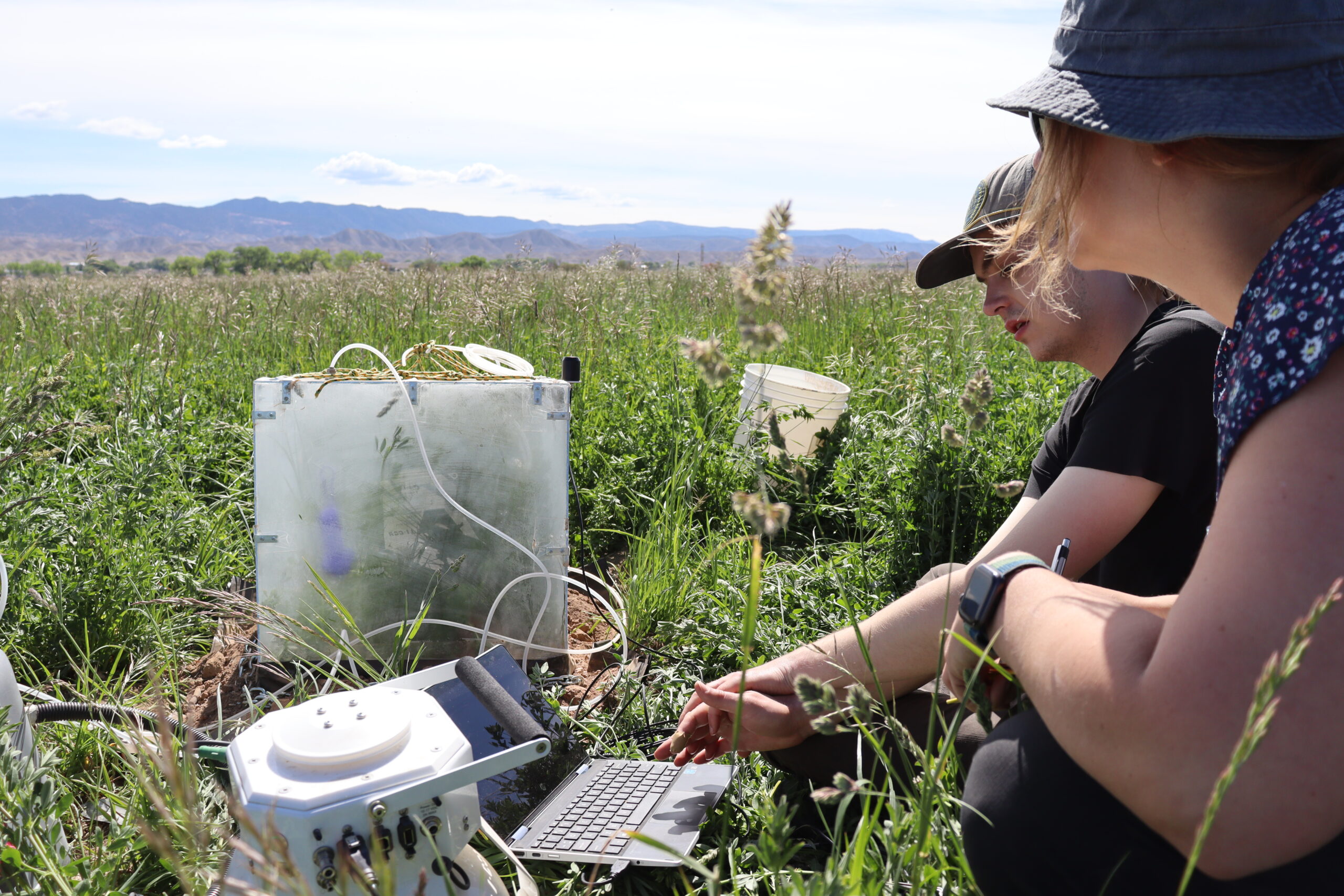
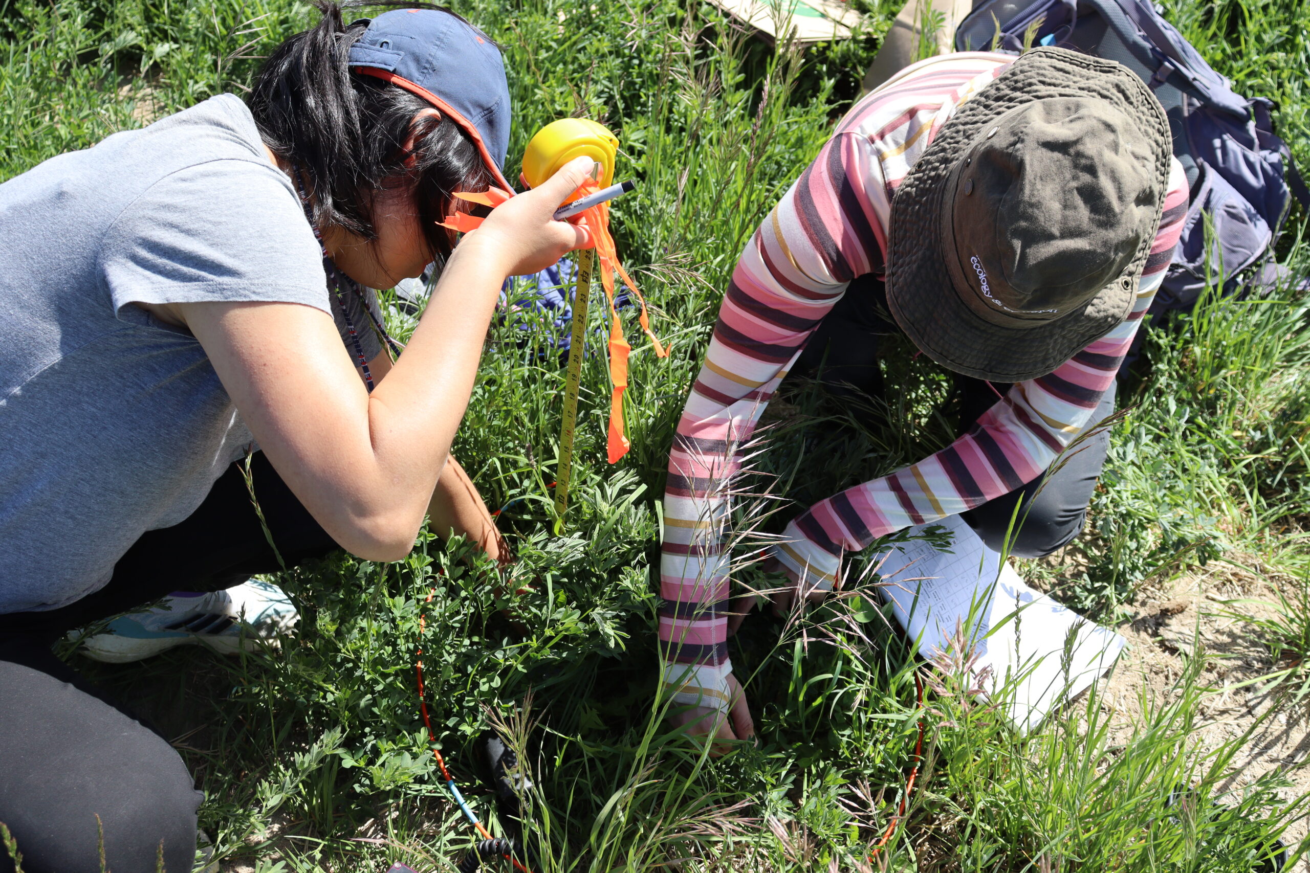
Plant productivity: What’s growing under-hoof?
Dr. Xia and Hernández-Yañez measure vegetation height.
photo by Sarah Ruiz
While plants are growing, they lock away carbon as part of their leaves, stems, and roots, so another important metric in the carbon model is plant productivity—more productive plants with established root systems are more likely to store more carbon belowground.
Productivity can be estimated with satellite imagery, but needs to be validated with on-the-ground measurements. Postdoctoral researcher Dr. Yushu Xia and research assistant Haydée Hernández-Yañez walked transects of pasture to collect data on a variety of indicators that could influence aboveground (and belowground) biomass, including height of vegetation, soil moisture, and temperature. Then the scissors come out and all the plants in a plot are cut and put into a labeled paper bag to be weighed and analyzed later in a lab to determine the total mass of plant matter.
Rangelands managed for better carbon storage also come with a host of co-benefits, including higher levels of plant diversity. Different plants cycle carbon and other nutrients at different rates, so Hernández-Yañez sifts through the vegetation before it’s snipped, identifying and recording the species to provide more detail in productivity estimates.
(audio) Dr. Xia and Hernández-Yañez walk a transect of pasture, collecting plant productivity data.
Soil carbon: What’s locked deep in the ground?
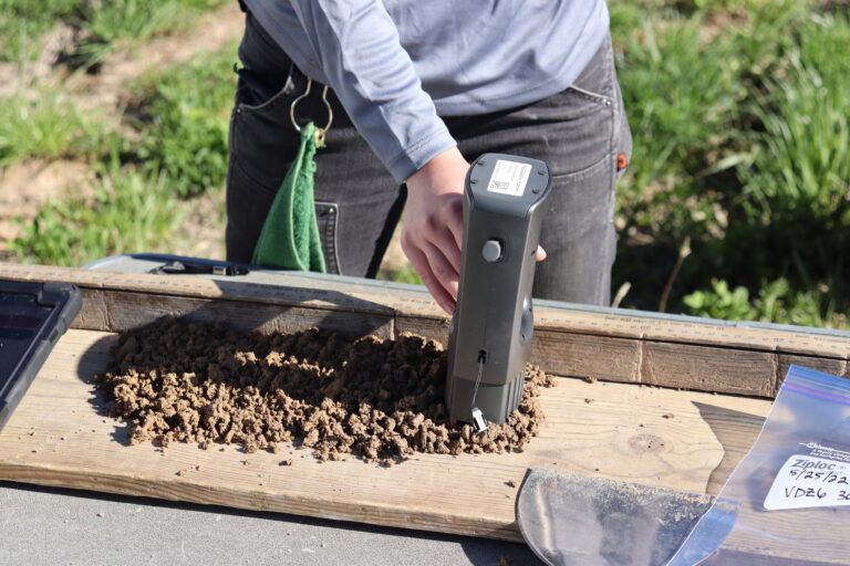
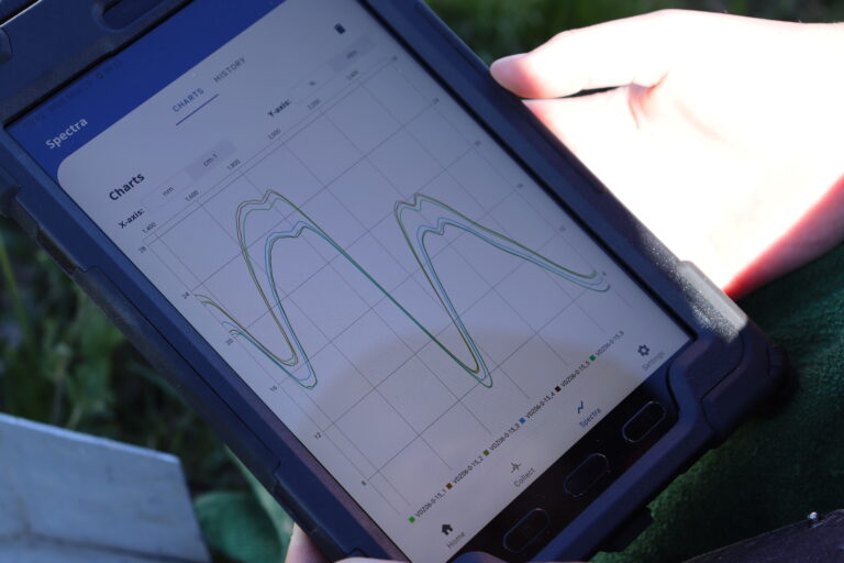
(left) Smith uses a handheld scanner to analyze soil carbon content recorded in a spectral graph (right).
photos by Sarah Ruiz
Over time, carbon passes out of the cycle of growth and decay, becoming locked underground as soil organic carbon. Accessing and analyzing soil organic carbon requires coring deep into the earth and pulling out a stratified cylinder of dirt. Dr. Machmuller led the team’s soil coring effort along with Dr. Sanderman and research assistant Colleen Smith.
With a hydraulic soil coring machine attached to the back of a pickup truck, the team rambled through muddy pasture and over sharp bushes to collect 50 centimeter cores. When the terrain was too steep, they pulled out a handheld corer that had to be driven into the soil with a sledgehammer.
The soil cores are separated into three sections and crumbled up. Smith then uses a handheld scanner that employs the same technology used by astronomers to determine the chemical makeup of distant star systems to read the carbon content of each section. The scanner bounces light off the soil particles and the pattern of reflection gives clues to what molecules are present at different depths. Abundance of carbon is sometimes obvious to the naked eye in the cores, showing up as darker, wet sticky soil.
(audio) Dr. Sanderman discusses the way soil builds carbon over time.
Putting data in the hands of land managers
Drs. Watts and Sanderman and their team are in the process of creating a rangeland carbon management tool that will make the soil carbon data model accessible directly to ranch managers. The website, developed by Dr. Xia, will generate data on carbon and plant productivity, for any geographic area down to the size of a single pasture. The hope is that the tool could be integrated into land managers long-term decision making, and show the results of adapting to more holistic, sustainable management practices over time.
“In the western US on our rangelands, just like in our croplands, we can change how we manage in a way that potentially could become a natural climate solution,” says Dr. Watts. “One where we’re bringing in more carbon than we’re emitting and we’re creating ecosystems that not only are beneficial for carbon sequestration, but also have more biodiversity, offer more habitat for wildlife, and more water conservation.”
Demonstrating the co-benefits of managing rangelands for carbon will also help expand conversations about whether ranching can be done sustainably, from the ground up.
“It allows for transfer of climate solutions into the hands of practitioners who may not otherwise think about climate change. It opens the conversation.” says Dr. Watts.
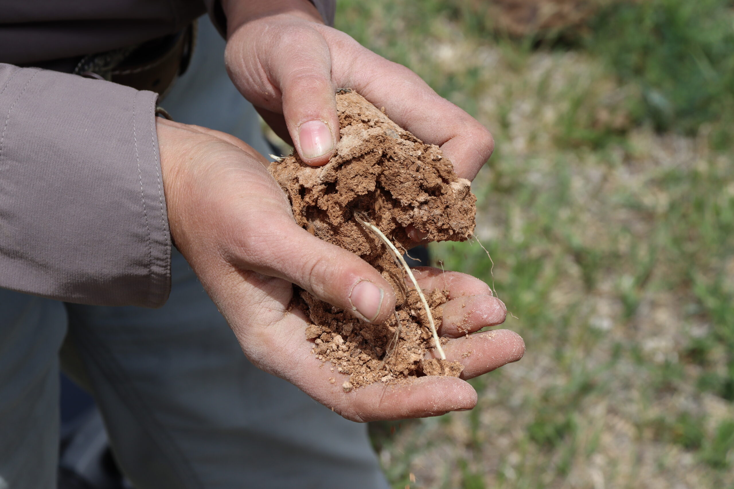
Roots can extend deep into the soil as shown in this core section from 50cm belowground.
photo by Sarah Ruiz
Ultimately, having that data could be useful for rangeland managers taking part in carbon credit markets, which could help them get paid for sustainable management
“Rangelands haven’t been included in voluntary carbon credit markets like cropping systems have,” says Dr. Sanderman. “Their monitoring is a big problem because there’s so much land. How do you keep track of all that? That’s what our tool will be able to offer.”