The sky opens up just as our truck leaves the last stretch of paved road. Water Program Director Dr. Marcia Macedo squints to stay focused on what she can see between wipes of the windshield. Within minutes, our path is transformed from a dirt road into a riverbed of bright orange mud, rutted from the passing of heavy trucks carrying soy off surrounding farms. Macedo swerves to dodge bumps and dips, but pretty soon there are more of them than there is flat road. We brace for the puddles, peering out windows spattered with orange spray.
It’s a Monday morning in the rainy season at the edge of the Amazon, and we’re commuting to work.
Tanguro Field Station lies about an hour’s drive from Canarana, the nearest town, located in a region of Brazil sometimes referred to as the arc of deforestation. Several decades ago, agriculture began surging into the southern reaches of the Amazon rainforest here, carving out rectangular patches of farmland from primary forest. For most of our drive, we are flanked only by mega-fields of soybean or scrubby cattle pastures.
Macedo, who has been conducting research at Tanguro since 2007, remembers a time when the drive could be marked by crossing a threshold from the Cerrado—Brazil’s woody savanna biome—into the Amazon. Now, clearing near the road has obscured that natural transition. Eventually clumps of lush green loom closer out of the rain and we know we’re nearly there.
Since its founding in 2004, Tanguro has offered researchers from around the world the opportunity to investigate big questions about how climate change and deforestation are affecting the Amazon. Macedo and her team have come to study Tanguro’s streams and reservoirs.
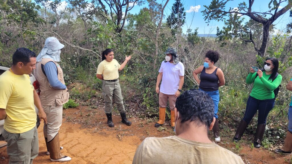
We pull to a stop outside the research station, hauling suitcases wrapped in plastic trash bags out of the truck bed. Research assistant Zoë Dietrich, clutches several vital electronic components to her chest, ferrying them to a screened-in porch to keep them out of the rain. Postdoctoral researcher Dr. Abra Atwood starts digging out sediment core tubes from a pile of equipment. The clouds drift off and the work day at Tanguro begins.
I. The Founding
It was a controversial decision at the time. “The decision to set up on the Tanguro ranch almost drove a wedge through us,” recalls Tanguro founder, Dr. Daniel Nepstad. “We had a discussion that lasted two days.”
Fourteen years prior, Nepstad had established the Amazon program at Woodwell Climate (then the Woods Hole Research Center) in the state of Pará, studying the resilience of Amazon forests during long dry seasons. This work gave rise to a new research institute based in Brazil. In 1995, Nepstad co-founded the Amazon Environmental Research Institute (IPAM) in Belém to pursue policy-relevant science that could inform sustainable development in the Amazon. Woodwell Climate and IPAM began conducting simulated drought experiments and found that the rainforest, long thought to be immune to fire, lost that resistance during severe droughts. To investigate the implications of this, Nepstad realized, they needed a new experiment somewhere at the edge of the Amazon, where it’s drier year-round.
Nepstad had been spending more and more time in the state of Mato Grosso, fascinated by the expansion of soybean cultivation into the Amazon there. During his search for a new study site, Grupo Amaggi reached out with a remarkable invitation.
Grupo Amaggi was, at the time, the largest soy producer in the world, and soy was rapidly becoming environmental enemy number one, as hundreds of thousands of acres of forests fell to expand its cultivation.
“But Grupo Amaggi, a Brazilian company, wanted to get out in front of the issue,” says Nepstad. The prospect of losing a major market in Europe raised questions about the best way forward. In 2002 they set up the first system for tracing the forest practices of the farmers who sold them soy. And in 2004 they extended an invitation to Nepstad to study the forests on their newly acquired Tanguro property— an amalgamation of previously-cleared cattle ranches they were in the process of converting to soy fields.
The hope was that the research would demonstrate to the world what was really happening in these massive soy farms in the Amazon, providing data that could contribute to conversations around sustainable soy.
“Twenty years ago there were lots of discussions about environmental preservation and agriculture,” says Grupo Amaggi’s ESG, Communications and Compliance Director, Juliana de Lavor Lopes. “Could those two create a symbiosis? I think we knew [they] could work together, but could we prove that?”
For Nepstad, the invitation was also the perfect opportunity to run a controlled fire experiment in an ideal location. After much debate, IPAM decided to accept.
“There were a lot of folks worried that this would ruin our reputation, undermine our credibility with grassroots organizations— a lot of NGOs felt like we were selling out,” says Nepstad. “Some people accused us of being bought off by Grupo Amaggi.”
But Nepstad was very clear on the terms of the partnership. They would accept no money from the company other than what Grupo Amaggi invested in the buildings on the research station campus. And they would only support the farm’s activities as far as the science allowed. The research would accurately report the impacts of agriculture on the forest, with no restrictions on publication.
So in 2004, barely funded, but accompanied by a dedicated team of field technicians and researchers from the drought experiments in Pará— some of whom are still employed at the field station today— Woodwell and IPAM set up camp at Tanguro.
II. Life at the Station
Muddy boots start lining up outside the door to the cafeteria at 11:50am. Dona Lúcia sets lunch out promptly at noon.
Maria Lúcia Pinheiro Nascimento has run the kitchen at Tanguro for over 16 years, cooking filling meals for hungry scientists and field technicians three times a day. Lunch and dinner usually involve some slow-cooked or grilled meat, rice, beans, and a fresh salad or roasted vegetables. Today there’s abóbora, a green-skinned pumpkin, and leftover sausage and brisket from last night’s churrasco. Breakfast is a lighter affair— pão de queijo, eggs, fresh bread, fruit, and coffee— set out and scarfed down before work starts at 7 am.
Many of the technicians who live and work here five days a week say Tanguro is like a second home, their peers a second family. For Dona Lúcia, as she’s called by staff and visitors alike, cooking for the research station isn’t just like cooking for family. It is cooking for family. Her husband, Sebastião Nascimento, “Seu Bate”, was one of the original field technicians working on the drought experiment in Pará. He flew down to join the crew at Tanguro a year after it was founded and brought his family down a year later, including his son, Ebis Pinheiro de Nascimento, who also joined as a field technician. A third technician from Pará, Raimundo Mota Quintino, known as “Santarém”, joined the family when he married Dona Lúcia’s daughter.
“I’m with my family,” she says. “It gives me joy.”
Related or not, the team at Tanguro works together like a family. Cooperation and respect are essential in a place as remote and disconnected (wifi only extends 60ft from the cafeteria building) as Tanguro.
“We joke that it’s like “Big Brother”,” says Field Manager, Darlisson Nunes da Costa. “But we are really united and we respect each other. That’s a wonderful environment to work in.”
It can also be a physically challenging environment, with long days in the heat and humidity, navigating safety concerns in a forest full of snakes and jaguars, territorial wild pigs and terrain that could easily twist an ankle. All the while ensuring the scientists get the data they need.
Every field technician has to be adaptable and multi-talented, because aside from meal times there is no day-to-day routine. Your morning might involve slashing vines to find a path to a hidden stream, selected from satellite imagery as a sampling location. The afternoon could be spent troubleshooting errors at one of the carbon-monitoring towers.
“We can’t say we have a fixed job,” says Seu Bate. “We do a bit of everything.”
All the same, the technicians have each developed their specialties over the decades. Santarém still uses waterman skills from his previous job as a fishing guide in the port city in Pará that gave him his nickname. He takes the canoe out on the reservoirs often, helping researchers pull sediment cores. Seu Bate can build whatever you need— whether it’s the aluminum base for a floating methane-monitoring chamber, or a custom collar to hold unwieldy soil core tubes while you sample them, just give him 20 minutes and some power tools. Nunes da Costa keeps the team’s field activities organized each week and can effortlessly cut a clear path through the forest. Ebis enjoys data collection, especially when it involves sampling the water or fishes in Tanguro’s waterways. For the station’s Scientific Projects Coordinator, Dr. Leonardo Maracahipes-Santos, climbing the 118 ft carbon tower is just like walking.
Outsider visits to Tanguro fluctuate. Sometimes weeks pass with only the field techs in residence, and sometimes the station’s small cabin-style houses and cheerful cafeteria are crawling with guests.
This spring has already been a busy one. Maracahipes-Santos handles day-to-day operations and organizes the rotating cast of visitors. In a few short weeks, he went from touring a crew of Brazilian journalists around the study sites, to working with collaborators from the Max Planck institute on routine maintenance to the carbon towers, to coordinating conversations between visiting researchers and Grupo Amaggi representatives about removing several dams on the property.
And even during slow weeks, there is plenty of science left to do—collecting samples for ongoing studies, running data analyses, checking on equipment. A day off is hard to come by at Tanguro, but at least it’s never boring.
“It’s very interesting, because we are part of a grand thing, which is to set up experiments in the field together with scientists,” says Nunes da Costa. “And we feel a little bit like scientists, because this whole business all starts on the ground. We can start from a piece of wood placed on the ground, and get all the way up to a scientific article. I feel very proud. Not only of me, but of the whole team.”
For her part, Dona Lúcia takes great pride in feeding the science at Tanguro.
“I’m very proud to be in a company like this, today,” says Dona Lúcia. “Nowadays, to work in a company like this, you need a degree, and I don’t have one. I don’t have a culinary degree. I don’t have any degree. But I learn every day.”
III. A Natural Laboratory
Field work wraps up at 4pm, leaving Macedo, Atwood, Nunes da Costa, and me sweaty and exhausted from an afternoon spent trudging through uneven wetlands to find stream channels. Atwood was dropping temperature loggers every 500 meters above and below reservoirs. She’s interested in the impacts these small water bodies have on the watershed, and how far downstream those impacts extend. But Amazonian streams often twist through impassable segments of marsh, so finding the sample sites requires vigorous hiking and a good machete.
After our hike, we rendezvous with the group of visiting journalists at the Darro Reservoir. One of the largest reservoirs at Tanguro, the Darro provides water to the research station for showers and cleaning. On especially hot days, it also makes a great swimming hole.
The water is warm—warmer than nearby streams, Atwood’s temperature data has confirmed—but still cooler than the muggy air. It’s also glassy clear. Our feet are visible treading the band of colder water down below. Billowing white reflections form on the surface, a perfect mirror of the clouds above.
Water is everything in the Amazon. It’s what makes the lush forests possible. It’s what connects a soy farm in Mato Grosso to estuaries at the yawing mouth of the Amazon River. And it’s what connects this region to the global climate. The clouds clustering above Darro grow heavier and darker with rain while we swim. Although much of that rain will fall back to Earth here, a large portion of it gets pushed out from the tropics to fall in other places.
“Water does two things,” says Woodwell Tropics Program Director, Dr. Mike Coe. “One: it’s rainfall somewhere else. Two: water is energy. It takes a huge amount of energy to evaporate water and that energy gets released somewhere else when it rains. So the energy from the sun that falls here gets transported around the world. That’s huge. That drives climate.”
Which means that, through water, changes here have the potential to cause major changes across the globe. Tanguro’s location in a region of the Amazon that underwent intense deforestation for agriculture just a few decades ago makes it an ideal place to study that cause and effect.
“Once you remove forests from the landscape, you change some things fundamentally that you can’t really undo,” says Macedo. “You change the amount of water in streams, you change the rooting depth of the plants on the landscape, you change the entire hydrological cycle.”
Tanguro is pretty representative of the changes experienced across the region. It’s a patchwork of natural forest, soy and cotton fields, and some planted eucalyptus groves. Some of its watersheds lie completely within the bounds of the forest, others run completely through agricultural land. Some streams have well preserved forests along their banks, while others are in the process of restoration. Amazonian species mix with those from the Brazilian savanna. It’s becoming hotter and drier as the climate changes. For the climate scientists and ecologists at Woodwell and IPAM, it’s the perfect natural laboratory.
As the first research project launched in that laboratory, the fire experiment garnered much fanfare.
“Grupo Amaggi had mobilized society, there were journalists and newspaper reporters and firefighters. People from the company and people from the local towns,” recalls Nepstad. It was new territory, intentionally burning the forest to learn how it changed the landscape. “It was really exciting.”
With each new year of burning, insights revealed themselves. One particularly hot, dry year, the forest burned even more than predicted. Nepstad recalled seeing flames, shin-high, still burning at 2 am the next morning. Tree mortality afterward jumped from its usual 6% up to 50%.
“That was tragic for that patch of forest,” says Macedo. “But it has yielded really important insights. Almost prescient. Just look at 2023: it was an incredibly dry year in the Amazon, and all of a sudden we saw fires in the very middle of the rainforest—areas that used to be much too wet to burn can now burn during a big drought.”
With the fire experiment underway, there was still nearly 200,000 acres of land available to study, so Nepstad invited researchers like Macedo, Coe, and Dr. Paulo Brando, who worked with Nepstad in Pará, to explore what other stories Tanguro might be able to tell about the Amazon. In its 20 year history, over 180 papers have been published from research at the station, ranging in topic from hydrologic changes, to the climatic limits on productive agriculture, to the degradation of forest carbon, to the value of tapir poop for restoration. Brando attributes the station’s prolific results to the knowledge of its staff.
“Part of Tanguro’s magic is to learn from the people who have been working for 20 years in the forest. They have an intuitive sense of what is happening with these forests’ health,” says Brando.
Another unique aspect of Tanguro’s location is where it sits in relation to the larger ecosystem. The hundreds of small streams that criss-cross Tanguro form the headwaters of the Xingu River—a major tributary to the main stem of the Amazon. Tanguro is just 60 kilometers from the Xingu Indigenous Territory, through which the river of the same name runs. Any upstream disturbances to nutrients, sediments, or stream outflow have the potential to ripple down to the reserve, impacting the livelihoods of Indigenous communities within.
“The headwater streams that we’re studying here at Tanguro drain into the Xingu reserve. So, these scientific questions of how water quality is being impacted by agriculture are important to understand as a cross-boundary issue,” says Macedo. “Water connects everything.”
IV. Connecting to the Community
When Tanguro General Coordinator, Dr. Ludmila Rattis, started her postdoctoral research at the field station, Canarana was a different town—small and male-dominated enough that a female environmental scientist had no hope of staying anonymous. Rattis would see her name written on bar tabs as “IPAM’s girl.” She went for runs and felt the stares.
It was a hard place to be, she recalls. “I felt watched all the time. I couldn’t do anything without bringing with me the name of an institution. And the internet connection was less than one megabyte, so Netflix was a challenge,” Rattis says. “Opening an email was a challenge.”
Working for an environmental non-profit in a farm town that owes its very existence to deforestation is sometimes tricky to navigate. But agriculture is woven into the DNA of Tanguro Field Station. Climate scientists may flinch to see bulldozers pressing into the undergrowth, but ultimately the proximity to agriculture here is what has yielded some of the station’s most valuable insights.
“By being here in this place for a long time, we’re able to observe changes as they happen, and say something much more confidently about what the broader impacts are on the Amazon,” says Macedo.
The partnership with Grupo Amaggi has also helped connect science to big decisions in the soy sector. In 2012, when debates over the future of Brazil’s forest code were roaring away, Nepstad was invited to join a field trip to Tanguro with the main lawmakers shaping the new code—including Senator Blairo Maggi, an owner of Grupo Amaggi. Seeing firsthand the experiments with forest restoration at the station helped demonstrate the feasibility of implementing the new protections. The forest code was revised and most of its restrictions on forest clearing are still in place today.
“It was really the science that opened these doors,” says Nepstad.
Rattis’s research, in particular, has gone a long way toward strengthening partnerships with farms around the region. She spent her year in Canarana talking with farmers about their experience of climate change—rainy seasons starting later, crop yields dropping—and asking what information they might find useful from climate models. Slowly, as she came back to them with her results, showing them rainfall and temperature predictions and keeping a dialogue open, she built a rapport that not only strengthened her relationship with the community, but helped guide future research.
“The farmers will tell you whether something looks right or not, and 90% of the time they’d say ‘wow, can you please send me that graphic? I want to show my neighbors,’” says Rattis. One new study even began after conversations with a farm manager hinted at a connection between forests and crop production. “I said we were wondering if the crops would produce more closer to the forest, and he said, ‘that makes sense because the cotton plants are bigger closer to the forest edge.’”
Researchers at Tanguro have also built connections with residents of the nearby Xingu Indigenous reserve, partnering with villages to study the downstream impacts of recurring fires. A professor with the Federal University of the Amazon (UFRA), Dr. Divino Silvério, who conducted his doctoral research at Tanguro, has led much of this work.
“The main idea was to integrate the scientific knowledge we had at Tanguro, with the traditional knowledge of the Indigenous people, to better quantify the impacts of fire on species that are used by them for food, construction, and medicine,” says Silvério.
During the study, Silvério and his research team visited the Xingu reserve to discuss the research and share insights. They also provided scholarships to several Indigenous students to help in the data collection and visit Tanguro for a knowledge exchange.
“Indigenous people have been managing the forests well for centuries,” says Silvério. “But now we have climate change. It’s becoming really urgent to have these kinds of conversations, to come up with some solutions to mitigate the impacts of climate change on the livelihoods of these people.”
Rattis also believes Tanguro has a role to play as an education hub. Over the last year she has been working to create an essay prize for local students, honoring an IPAM employee who championed environmental education in the 2000s.
“The Tanguro we have today is the legacy of the many people that have worked there,” says Rattis.
V. What does the future look like?
Maracahipes-Santos has climbed this tower a thousand times. Today he’s climbing it once more, to anchor a back-up belay line to one of its top struts. If one of us passes out mid-climb, at least they’ll be able to lower us down gently. If all goes well, we will be climbing the 118 feet up and back under our own power, anchored to the center of the tower with a mechanism that locks like a seatbelt under sudden downward force.
The tower itself is essentially an overgrown ladder, with various gas and weather analyzers strapped to spindly poles at the top. There are three of them stationed around Tanguro to monitor the movement of carbon dioxide, water vapor, and other gasses into and out of the landscape. This particular tower is a 15 minute hike into a section of intact forest that was used as the control site during the fire experiment.
After checking and rechecking my tethers, a shout from Maracahipes-Santos, already at the top, signaled it was time to start the climb.
One hand up a rung, then the other. Feet to follow. Step, step, breathe. You’re supposed to lean back, let the harness hold you and push your weight up with your legs, but an unshakable instinct makes me pull tight to the ladder, so when I reach the top my forearms are shaking. Sweaty, breathless, flushed, but above the canopy at last. Maracahipes-Santos smiles and attaches my safety hook to one of the struts. Up here, we are taller than the trees.
From the top of the tower, you can read the history and future of this place, just by turning your head. Forest stretches to the horizon in one direction, an unbroken mosaic of deep green. In another, you can see massive rectangles of red dirt and uniform carpets of pale green soy cut into the landscape. Somewhere hidden behind a copse of planted eucalyptus are the corrugated metal roofs of the research station. Rain is falling on the horizon.
Not too many decades ago, this was all forest. Just another impossibly thick cluster of living organisms breathing and dying and growing anew in one of the most densely biodiverse ecosystems on the planet. Now, the vigilant scientific instruments whizzing away up here document its decline.
Research at Tanguro is driven by one big question: “What is the future of the Amazon?” But the answer to that question will depend — on scientists continuing to come to Tanguro to understand how this ecosystem is changing, on the field technicians making it possible to conduct science in the forest safely, on farmers taking pride in caring for the forests that stand on their land, on government officials building policies that reflect science, and on the decisions of people thousands of miles away to reverse climate change.
“When you’re doing research on this forest, you realize it is an amazingly tough system that is now being faced with tougher and tougher stresses and disturbances. So it needs help, and it needs to be given a chance, but it will continue,” says Nepstad. “And I think Tanguro has a big role to play in that.”
The past 20 years at Tanguro have done much to point the Amazon towards a more hopeful future. What will the next 20 bring?
“My hope,” says Rattis, “is that in 20 years we won’t be dealing with deforestation anymore. ‘Remember that time when we had to convince people not to cut down the forest? I’m so glad we’re past that.’”
“Why not float the aquatic greenhouse gas chamber on a surfboard?” Tropics Program Director Dr. Mike Coe suggested in one of our team meetings, and I could feel the gears in my brain begin turning. I started a sketch… If mounted on a surfboard, we would need a method to open the chamber, flushing it with outside air. Back in my office, I asked Google “what turns electrical energy into mechanical energy?” Google was quick to respond, “Motor.” Right, thank you, Google. Next, I typed, “motor that pushes something up.” Google replied, “linear actuator.” Three clicks later and I had ordered my first linear actuator for 35 bucks.
Three days later, that linear actuator sat expectantly on my desk. One red wire and one black wire, “12V DC” printed on its side. I turned back to Google, “How to wire a linear actuator?” Opening the first hit, I skimmed through the photos and diagrams. None of them striking my fancy, I moved on to the second hit: Step-by-step instructions, clear photos, even open-source code to program my Arduino microcontroller board – nice! Within an hour, my linear actuator was extending and retracting on command, ready to be mounted in an autonomous greenhouse gas chamber.
Adding the actuator to my sketch, I popped into Senior Research Scientist Kathleen Savage’s office to hear her thoughts. Savage always has new ideas brewing, and she suggested adding a feature that would allow the chamber to function on water and on land. The chambers are the product of a Fund for Climate Solutions (FCS) grant led by Savage to quantify carbon dioxide and methane emissions from small water bodies like lakes, ponds, and reservoirs. Because there are no low-cost and auto-sampling tools available on the market, we have been developing a new instrument to measure these emissions.
DIY science
“Chamber” is a fancy word for the upside-down buckets we use to measure how fast greenhouse gasses are released from different surfaces. By resting a bucket upside-down on a patch of soil or grass or water and measuring how fast gas concentrations increase or decrease inside the bucket, we can calculate a “flux” of gas over a set area and time. Common methods of measuring fluxes require manually collecting gas samples from a chamber to be processed in a lab, or connecting the chamber to a high precision analyzer that can cost around $40,000. These methods are costly in salary time and equipment, limiting where, when, and how often people can sample—usually daytime and in accessible areas and times of the year. We need new low-cost and autonomous systems that can measure around the clock to improve carbon emissions estimates. The recent commercialization of cheaper sensors and control systems to operate them, like the Arduino microcontroller, now make these developments possible.
I’m building a new floating chamber that measures aquatic fluxes autonomously using a $15 methane sensor and a $78 carbon dioxide sensor, improving previous designs published by Dr. David Bastviken’s group at Linköping University in Sweden. Powered by a solar panel and battery, the sensors measure gas concentrations, temperature, and humidity inside the chamber every 30 seconds. The data is stored on an SD card and transmitted within 50 meters via radio. The radio transmission allows us to check that the chamber is functioning properly from the shore and to see chamber measurements in real time. When gas concentrations have increased enough to discern a flux, the linear actuator extends to open the chamber, flushing the interior with outside air before retracting to close the chamber again for another flux measurement. Calibrating the chamber with a high precision analyzer in the field shows the low-cost sensors perform well, with an accuracy of approximately 1 ppm for methane and 3 ppm for carbon dioxide.
Field deployment
I first tested chamber prototypes last July on agricultural reservoirs at the Tanguro Field Station in Brazil. At the end of our field campaign, I left one chamber deployed to see how long the electronics would last and which components might eventually fail. After helping me deploy and calibrate the chamber, field technician Raimundo “Santarém” Quintino monitored it, checking its “vital signs” via radio every few weeks. In January, he noticed the linear actuator had stopped pushing the chamber open.
During a follow-up field campaign in March, I brought a couple of extra linear actuators and five more chambers to deploy on additional reservoirs at Tanguro. Tanguro staff and I worked together to modify chamber components that didn’t function well in the first deployment. These modifications included swapping the materials of the floating foam bases and improving the mounting mechanisms of the linear actuator and chamber hinge. Our adjustments were informed by recommendations from a Laboratory Operations Manager at the University of Maine in Orono (Christopher London), whom I met while doing fieldwork at the nearby Howland Research Forest. Woods Hole locals, such as John Driscoll and Fred Palmer of the Woodwell Climate Facilities department, kite foiler and carpenter Tad Ryan, and employees at Eastman’s Hardware, have also offered transformative recommendations on building materials and techniques to stabilize the floating chambers.
Working hands-on with the floating chambers on the reservoirs, Santarém, Dr. Leonardo Maracahipes-Santos, Tanguro’s Scientific Projects Coordinator, and Sebastião “Seu Bate” Nascimento of Tanguro Field Station have made invaluable improvements to the chamber design and deployments. A few of their contributions include advice on safe deployment locations, monitoring and collecting data from the chambers over time, and constructing aluminum and galvanized steel components for the floating bases. They also designed a new mount for the most recent chamber addition—a bubble trap that uses an inexpensive pressure sensor to autonomously measure the volume of gas released as bubbles.
Freshwater ecosystems worldwide emit nearly half as much carbon dioxide and methane as fossil fuel combustion. On the Amazon-Cerrado frontier, where Tanguro is located, there are hundreds of thousands of small agricultural reservoirs, which are important, yet overlooked, greenhouse gas sources. These artificial ponds—installed to provide drinking water for cattle, facilitate road crossings, or supply energy at the farm scale—can persist for decades, creating low-oxygen conditions that drive methane production. Monthly sampling of six reservoirs over a year by Water Program Director Dr. Marcia Macedo revealed high methane and carbon dioxide emissions, varying with season and reservoir size. But these measurements did not capture the significant variability that can occur on daily, monthly, and annual time scales, including transient “hot spots” and “hot moments” of high greenhouse gas emissions.
This lack of frequent measurements hinders climate scientists’ ability to integrate emissions at the reservoir scale in order to estimate cumulative greenhouse gas emissions at the landscape scale. The autonomous floating chambers will address that gap, enabling comprehensive carbon monitoring and modeling of the reservoirs.
From the tropics to the Arctic
Additionally, these chambers are versatile tools that can be used across different environments. Funded by a subsequent FCS grant, six new floating chambers will accompany me to the Yukon-Kuskokwim Delta, Alaska, this summer to measure greenhouse gas emissions from Arctic ponds. The chambers will supply the frequent data necessary to constrain the LAKE model utilized by Arctic Program scientists Dr. Elchin Jafarov and Andrew Mullen. The model predicts variations in carbon emissions from ponds, providing insight into processes regulating methane and carbon dioxide. By applying the LAKE model to both Arctic ponds and Amazon reservoirs, we can gain a deeper understanding of their impacts on regional greenhouse gas budgets.
“Deploying floating chambers will streamline the process of gathering aquatic data and enhance the temporal resolution of the data, which is vital for modeling and currently absent in existing datasets,” notes Jafarov.
Problem-solving and collaboration
While calibrating the low-cost sensors in our boat one March afternoon, Santarém and I noticed the linear actuator on another nearby chamber wasn’t retracting and extending as it should. Expecting another replacement was in store, we tuned into the radio and popped open the electronics case to check for “symptoms.” Blinking lights and radio silence revealed an entirely new and perplexing issue causing the malfunction.
Building this system from the ground up over the last year, the one constant has been mind-bending electronics puzzles that keep me up at night. As a biogeochemist by training, these problems usually require some tinkering, a dictionary, a lot of Googling, and sometimes bugging electrical engineers down the street at the Woods Hole Oceanographic Institution (Lane Abrams) and Spark Climate Solutions (Bashir Ziady), whose advice and contributions have substantially improved the chambers’ electrical designs. Each problem can usually be traced to a perfectly logical, satisfying solution, leaving me feeling wiser and excited to tackle the next one. I’ve tracked this new problem down to something potentially involving a “memory-leaking variable declaration” in my new bubble trap programming code. I might’ve fixed it with a “watchdog timer.” Both are new words for me, too. If the watchdog timer doesn’t pan out, Santarém and I will try another fix.
Designing, building, and testing these chambers has been an iterative and constantly evolving process. What works well? What doesn’t? How can we do this more simply? Using less energy? For a lower cost? How can we improve the design so that other researchers can easily build these floating chambers as well? Soon we plan to publish open-source instructions detailing how to build and troubleshoot the floating chambers—I have already sent preliminary instructions to three interested research groups. I’m lucky to collaborate with many talented people from Woods Hole to Maine and Brazil, many of whom are as new to chambers and fluxes as I am to engineering. Nevertheless, these floating chambers incorporate a brilliant flourish from each of them.
When it comes to reversing climate change, trees are a big deal. Globally, forests absorb nearly 16 billion metric tonnes of carbon dioxide per year, and currently hold 861 gigatonnes of carbon in their branches, leaves, roots, and soils. This makes them a valuable global carbon sink, and makes preserving and maintaining healthy forests a vital strategy in combating climate change.
But not every forest absorbs and stores carbon in the same way, and the threats facing each are complex. A nuanced understanding of how carbon moves through forest ecosystems helps us build better strategies to protect them. Here’s how the world’s different forests help keep the world cool, and how we can help keep them standing.
Tropical forest carbon
Tropical rainforests are models of forest productivity. Trees use carbon in the process of photosynthesis, integrating it into their trunks, branches, leaves, and roots. When part or all of a tree dies and falls to the ground, it is consumed by microorganisms and carbon is released in the process of decay. In the heat and humidity of the tropics, vegetation grows so rapidly that decaying organic matter is almost immediately re-incorporated into new growth. Nearly all the carbon stored in tropical forests exists within the plants growing aboveground.
Studies estimate that tropical forests alone are responsible for holding back more than 1 degree C of atmospheric warming. 75% of that is due simply to the amount of carbon they store. The other 25% comes from the cooling effects of shading, pumping water into the atmosphere and creating clouds, and disrupting airflow.
In many tropical forest regions, there is a tension between forests and agricultural expansion. In the Amazon rainforest, land grabbing for commodity uses like cattle ranching or soy farming has advanced deforestation. Increasing protected forest areas and strengthening the rights of Indigenous communities to manage their own territories has proven effective at reducing deforestation and its associated emissions in Brazil. “Undesignated lands” have the highest levels of land grabbing and deforestation.
Fire has also become a growing threat to the Amazon in recent years, used as a tool to clear land by people illegally deforesting. When rainforests have been fragmented and degraded, their edges become drier and more susceptible to out-of-control burning, which weakens the forest even further. Enforcing and strengthening existing anti-deforestation laws are crucial to reduce carbon losses.
In Africa’s Congo rainforest, clearing is usually for small subsistence farms which, in aggregate, have a large effect on forest loss and degradation. Mobilizing finance to scale up agricultural intensification efforts and rural enterprise within communities, while implementing protection measures, can help decrease the rate of forest destruction. Forests and other intact natural landscapes such as wetlands and peatlands could be the focus of climate finance mechanisms that encourage sustainable landscape management initiatives.
Temperate forest carbon
Much of the forest carbon in the temperate zone is stored in the trees as well— particularly in areas where high rainfall supports the growth of dense forests that are resilient against disturbances like drought or disease. The temperate rainforests of the Northwestern United States, Chile, Australia, and New Zealand contain some of the largest and oldest trees in the world.
Two thirds of the total carbon sink in temperate forests can be attributed to the annual increase in “live biomass”, or the yearly growth of living trees within the forest. This makes the protection of mature and old-growth temperate forests paramount, since older forests add more carbon per year than younger ones and have much larger carbon stocks. Timber harvesting represents one of the most significant risks to the carbon stocks in temperate forests, particularly in the United States where 76% of mature and old growth forests go unprotected from logging. Fire and insects are also significant threats to temperate forests particularly in areas of low rainfall or periodic drought.
Maintaining the temperate forest sink means reducing the area of logging, by both removing the incentive to manage public forests for economic uses and by providing private forest owners with incentives to protect their land. Low-impact harvesting practices and better recycling of wood products can also help bring down carbon losses from temperate forests. In areas threatened by increasingly severe wildfires, reducing fuel loads especially near settlements can help protect lives and property.
Boreal forest carbon
In boreal forests, the real wealth of carbon is below the ground. In colder climates, the processes of decay that result in emissions tend to lag behind the process of photosynthesis which locks away carbon in organic matter. Over millennia, that imbalance has slowly built up a massive carbon pool in boreal soils. Decay is even further slowed in areas of permafrost, where the ground stays frozen nearly year round. It estimated that 80 to 90% of all carbon in boreal forests is stored belowground. The aboveground forest helps to protect belowground carbon from warming, thaw, decay, and erosion.
Wildfire— although a natural element in boreal forests— represents one of the greatest threats to boreal forest carbon. With increased temperatures, rising more than twice as fast in boreal forests compared to lower latitudes, and more frequent and long-lasting droughts, boreal forests are now experiencing more frequent and intense wildfires. The hotter and more often a stand of boreal forest catches fire, the deeper into the soil carbon pool the fire will burn, sending centuries-old carbon up in smoke in an instant. Logging of high-carbon primary forests is also a big issue in the boreal.
The number one protection for boreal forest carbon is reducing fossil fuel emissions. Only reversing climate change will bring boreal fires back to the historical levels these forests evolved with. In the meantime, active fire management in boreal forests offers a cost effective strategy to reduce emissions— studies found it could cost less than 13 dollars per ton of carbon dioxide emissions avoided. Strategies for fire management included both putting out fires that threaten large emissions, and controlled and cultural burning outside of the fire season to reduce the flammability of the landscape.
Fund for Climate Solutions awards five new grants
From the Arctic to the Tropics, the 2024 winter cohort of FCS projects fills information gaps to produce actionable insights
Quantifying large greenhouse gas emissions from a retrogressive thaw slump in Alaska
Lead: Jennifer Watts
Collaborators: Kyle Arndt, Patrick Murphy
Retrogressive thaw slumps (RTS) are extreme permafrost thaw landscape features, which occur when a section of ice-rich permafrost becomes warm enough to cause the ground ice to melt and soils to collapse. Once they start, RTS continue to expand and destroy nearby permafrost for months to years. Many RTS have been identified, but because they are often in extremely remote arctic locations, very little is known about the potentially substantial carbon emissions from RTS in the form of carbon dioxide and methane. This study will provide the first continuous measurements of carbon emissions from a RTS, collected over at least a year via an eddy covariance tower. The research is also supported by an equipment loan provided through the U.S. Department of Energy AmeriFlux Rapid Response program, which recognized this project as a valuable opportunity to advance science. The data collected will also serve as a “proof of concept” for a subsequent $1.3M proposal to the National Science Foundation for continued research at the site.
Assessing the impacts of ecosystem disturbance on carbon emissions from Arctic and Amazon ponds
Lead: Elchin Jafarov
Collaborators: Zoë Dietrich, Andrew Mullen, Jackie Hung, Marcia Macedo, Kathleen Savage
Freshwater ecosystems are significant sources of the greenhouse gases that persist in the atmosphere and contribute to warming. However, research is lacking an understanding of how disturbances like wildfire and agriculture can change these emissions. This project will address these information gaps by collecting measurements of carbon emissions from ponds, using autonomous floating chambers developed with funding from a previous FCS grant. With this new high-resolution data, the team will unlock the ability to predict year-round greenhouse gas emissions from ponds in the Arctic and the Amazon. Floating chambers will be deployed in ponds in Alaska affected by wildfires, and in agricultural reservoirs in the Amazon-Cerrado frontier. In both locations, the ability to take more frequent measurements of carbon emissions will help researchers improve models and better assess the ponds’ impacts on regional carbon budgets.
The Polaris Project: Data synthesis from almost two decades of research and student participation
Lead: Nigel Golden
Collaborator: Sue Natali
Established in 2008, the Polaris Project has earned global recognition for its leadership in Arctic research, education, and outreach. Through the commitment to providing students with hands-on experience, Polaris has enabled numerous publications and presentations. Polaris is approaching a critical juncture in the next funding cycle, and this project will complete the first-ever comprehensive synthesis of Polaris Project research to help sustain Woodwell Climate’s sole undergraduate research program. By consolidating past research and educational achievements, the team will create a data synthesis paper to be submitted to a peer-reviewed, open-access scientific research journal, as well as a retrospective analysis of undergraduates’ research experiences with Polaris to be submitted to an education research journal. The team will also launch an online communications piece that documents past Polaris participants’ field experiences and unique journeys with a variety of narrative and artistic communications styles and elements.
Determining the climate sensitivity of coastal rivers to guide ecosystem restoration across SE Massachusetts
Lead: Abra Atwood
Collaborators: Marcia Macedo, Chris Neill, Linda Deegan, Scott Zolkos
Coastal rivers, like those that flow into Massachusetts’ Buzzards Bay and Vineyard Sound, are fragile environments that serve critical ecological functions for native fish, downstream estuaries, and coastal wetlands. Different rivers are uniquely sensitive to changes in air temperature based on a variety of characteristics, such as their water source or shade. However, land use changes, including housing development and cranberry bogs, have affected key river characteristics and stream temperatures. This project will investigate MA coastal rivers’ sensitivity to changing air temperature, as well as how that sensitivity is affected by both connection to groundwater and the creation or restoration of cranberry bogs. The temperature sensors and geochemical analyses used in this research may be scalable beyond these rivers and yield insights to inform research approaches relevant to rivers around the world.
A drought early warning system for the DRC: Developing a seasonal forecast based on novel machine learning approaches
Lead: Carlos Dobler-Morales
Collaborators: Christopher Schwalm, Glenn Bush
Seasonal weather forecasts hold immense potential to improve risk management from agricultural failure, water stress, and extreme events. However, significant advances in technical forecasting capabilities remain largely unavailable to communities without the resources to develop or customize them for their region. In 2023, Woodwell Climate Just Access co-produced a national climate risk assessment with the Democratic Republic of Congo’s Ministry of Environment and Sustainable Development. That report identified drought as a major climate threat to the DRC—one which stands to affect almost the entire country. In response, this project will develop a seasonal drought forecasting model tailored to the DRC using cutting-edge machine-learning methods. The forecast will be able to deliver precise rainfall anomaly predictions up to six months in advance for the whole country, and serve as an early warning system to help local people and decision-makers anticipate the impacts of escalating drought risk.
Learn more about the Fund for Climate Solutions.
A recent paper, led by Woodwell Climate postdoctoral researcher Dr. José Safanelli, revealed that Brazil’s farms have been steadily moving out of the most suitable regions for agriculture—opening up a significant portion of the world’s agricultural production to vulnerability from the changing climate.
The study, published in Applied Geography, used an index to assess “Grain-cropping suitability” for two key staple crops—soy and maize. Suitability was determined by climatic factors (temperature and precipitation), as well as soil quality and terrain. The result was a continuous map detailing the areas of the country with the best biophysical conditions for growing crops.
Overlaying land use change data from the past two decades with this new map revealed a historical trend of agricultural lands expanding towards areas with poorer soil quality and lower suitability for grain-cropping, primarily in the north central and northeastern portion of the country.
Understanding Brazil’s agricultural migration
Farmers in Brazil have been moving north to this “agricultural frontier” since the 1980s— drawn primarily by economic opportunity, as well as the higher quality climate and terrain conditions along the southern edge of the Amazon.
Despite the favorable climate, the soil is inferior. Farmers are seeking cheap land, which often comes in the form of degraded pasture, originally created by clearing forest. Rainforest soils are not naturally nutrient rich and, without any additional inputs, the soil quality becomes depleted after just a few years. Many farmers know this fact, but come anyway. Dr. Safanelli has even seen this trend unfold within his own family.
“I was born in the south of Brazil, a region that has good soil conditions. Recently, two of my uncles who are farmers emigrated to Mato Grosso. There, the climate is wetter and more stable, but the soils are poor—depleted of nutrients.”
Additional research by Woodwell Climate Assistant Scientist Dr. Ludmila Rattis suggests that climatic advantage may be short-lived. Her work indicates that the climate in these areas is changing— becoming drier and hotter as global temperatures rise—and deforestation for agricultural expansion just makes the problem worse.
“We showed in our paper that these places have good climate and terrain suitability for now,” says Dr. Safanelli. “But they are restricted in soil quality. In Mato Grosso—the largest agricultural production state in Brazil—for example, the climate has been more stable and favorable than in other parts. The problem is that, according to projected climate scenarios, climate change may push these areas out of a good suitability space.”
What this means for agriculture in Brazil
Brazil is currently the world’s top producer of soy, and in the top three for maize. But this expansion into lower-suitability regions has introduced greater vulnerability into the agricultural system. Farmers already must provide greater investment in fertilizing the soil to make it productive, which cuts into their margins for profit. Add to that the fact that poor-quality soils, typically low in organic matter, can make crops less resilient to extreme heat and drought.
“Crop evapotranspiration—a process that directly governs crop growth and yield—depends on soil for absorbing rainfall and storing water. These marginal soils can make farmers more susceptible to climate change’s expected drier and warmer conditions, as they have limited capacity for storing water,” says Dr. Safanelli.
Reducing these vulnerabilities, Dr. Safanelli says, will require an integrated approach— improving land management practices and increasing crop yields on existing land to reduce the pressure to expand. “Reducing the vulnerability of croplands may be possible by adopting management practices that increase the resilience of the farming system, such as fully incorporating the principles of conservation agriculture, integrated production through agroforestry, crop-forest-livestock systems, or irrigation to control dryness. And perhaps allocating some of these marginal lands for land restoration, concentrating our resources in more highly suitable croplands.”
What’s New?
A recent paper offers new insight into the state of global forests. Using remote sensing imagery from MODIS satellites, researchers were able to categorize forest condition in two important biomes—the Amazon and the Siberian Taiga—differentiating between high stability, low stability, and non-forested areas. These “stability classes” provide another metric of assessing the conservation and carbon value of land, as high stability forests tend to be healthier, more resilient, primary forest stands that store large amounts of carbon and contribute to cooling the planet more than lower stability forests.
“Mature forests have higher biodiversity and create their own microclimate,” says paper co-author and Woodwell Associate Scientist, Brendan Rogers. “They’re more resistant to drought and other types of disturbance. And then because of that, they tend to be more stable in the face of environmental perturbations over time.”
Understanding forest stability
To estimate forest stability, researchers analyzed satellite data that combined measures of photosynthetic radiation with a canopy water stress index. That new approach was able to identify whether or not a forest has been disturbed by either human land use (ex. logging) or natural processes (wildfire, insects outbreaks, etc.) and map the degradation level.
Co-author Dr. Brendan Mackey from Griffith University in Australia says that stability mapping is a first critical step in making an inventory of the world’s remaining primary forests which store more carbon, support the most biodiversity, and deliver the cleanest water.
According to Dr. Rogers, the less interruption in the ecological processes of the forest, the more secure the carbon stored in both the trees and soils are. Further human interference in an unstable forest could tip it into decline.
“I think one of the problems for primary forest conservation globally has been this idea that it’s either a forest or not a forest. So, internationally agreed upon definitions of what constitutes a forest sets a pretty low bar. You can get away with calling a plantation with very young trees a forest, but that could have been converted from a high biomass mature forest, and they’re simply not the same—not in terms of carbon, biodiversity, or ecosystem services,” says Dr. Rogers.
What this means for forest conservation
Using a gradient of forest stability instead of a black and white definition of forest/not-forest allows for more nuanced decision-making where both carbon monitoring and conservation planning are concerned.
“The first priority is to protect stable forests from further human disturbance, as once an area is deforested, it takes decades to centuries—and in some cases millenia—for it to regrow to a primary state. The second priority is to identify forest areas where restoration efforts will be most cost effective,” says Dr. Mackey.
According to the paper’s lead author, Dr. Tatiana Shestakova, this means places where a small investment could have bigger positive results.
“If you pick a forest that was degraded in some way, but it still keeps patches of more or less healthy forests, you can reinstate ecological processes faster and easier,” says Dr. Shestakova.
Dr. Shestakova said she encourages other researchers to apply the methods to their particular regions of expertise and expand estimates of forest stability globally.
“The benefit of this approach is that it was tested in such contrasting ecoregions, and has been proven to be a simple and efficient way to assess this important dimension of forest condition,” says Dr. Shestakova.
The Amazon rainforest is one of the planet’s best natural climate solutions. Roughly 123 billion tons of carbon are estimated to be stored in the trees and soils of the Amazon and, if protected, it has the power to continue sequestering billions of tons of carbon each year.
But that irreplaceable carbon sink is under steady threat from a cycle of deforestation, fire, and drought that is both exacerbated by and contributing to climate change. Preliminary analysis from Woodwell of last year’s data has outlined that the most vulnerable regions of the Amazon are where drought and deforestation overlap.
2021 data shows deforestation drives fire in the Amazon
Unlike temperate or boreal forest ecosystems—or even neighboring biomes in Brazil— fires in the Amazon are almost entirely human caused. Fire is an intrinsic part of the deforestation process, usually set to clear the forest for use as pasture or cropland. Because of this, data on deforestation can provide a good indicator of where ignitions are likely to happen. Drought fans those flames, producing the right conditions for more intense fires that last longer and spread farther. Examining the intersection between drought and deforestation in 2021, Woodwell identified areas of the Amazon most vulnerable to burning.
Areas of deforestation combined with exceptionally dry weather to create high fire risk in northwestern Mato Grosso, eastern Acre, and Rondonia. Although drought conditions shifted across the region throughout the course of the year, deforestation caused fuel to accumulate along the boundaries of protected and agricultural land.
These areas of concentrated fuel showed the most overlap with fires in 2021, indicating that without the ignition source that deforestation provides, fires would be unable to occur, even during times of drought.
In June of 2021, we identified a dangerous and flammable combination of cut, unburned wood and high drought in the municipality of Lábrea, that put it at extreme risk of burning. Data at the end of December of 2021 confirmed this prediction. The observed fire count numbers from NASA showed that last year, Lábrea experienced its worst fire season since 2012.
Fires and climate change form a dangerous feedback loop
As a result of deforestation in 2021, at least 75 million tons of carbon were committed to being released from the Amazon. When that cut forest is also burned, most of the carbon enters the atmosphere in a matter of days or weeks, rather than the longer release that comes from decay.
This fuels warming, which feeds back into the cycle of fire by creating hotter, drier, conditions in a forest accustomed to moisture. Drought conditions weaken unburned forests, especially around the edges of deforestation, which makes them more susceptible to burning and releasing even more carbon to the atmosphere to further fuel warming.
Fire prevention strategies enacted by the current administration over the past 3 years have been insufficient to curb burning in the Amazon, because the underlying cause of deforestation remains unaddressed. Firefighting crews are not sufficiently supported to continue their work in regions like Lábrea that are actively hostile to combating deforestation and fire. If deforestation has occurred, fire will follow. To ensure the safety of both the people and the forests in these high-risk municipalities, the root causes of deforestation must be addressed with stronger and more strategic policies and enforcement.
Woodwell workshop brings Indigenous firefighters to Brasilia
A week-long workshop encourages knowledge sharing between Indigenous Brazilian fire brigades
On March 28, 2022, firefighters from Indigenous communities across Brazil gathered in Brasília, the country’s capitol, for a week-long geography and cartography workshop. The workshop, a collaboration between the Coordination of Indigenous Organizations of the Brazilian Amazon (COIAB) and the Amazon River Basin (COICA), IPAM Amazônia, and Woodwell Climate Research Center, walked participants through the basics of using Global Information Systems technology to monitor and manage their own lands and forests.
Forests and native vegetation on Indigenous lands have been sustainably managed for millenia, and studies have found Indigenous stewardship of forests is an effective measure for preventing deforestation and degradation. Escaped fires can present a threat to forests, and many Indigenous communities have their own brigades that work on detecting and preventing runaway fires. In some places, prescribed burns are used as a tool for shaping and cultivating the land.
Participants attended from Indigenous lands located in a variety of Brazilian landscapes—from the Cerrado to the heart of the Amazon. Despite differences, participants found learning from other Indigenous communities extremely valuable.
“People came with a variety of skill sets,” said Woodwell Water Program Director Dr. Marcia Macedo. “What was most meaningful for participants was seeing other people like them, who do the same work and are also Indigenous people, already dominating material, knowing how to make the maps, and helping others. It gave them confidence that they could also figure it out.”
After a day of introduction to the core concepts of GIS and mapping, participants headed out to Brasília National Park to test their newfound skills. They visited burned areas from both an escaped fire and a prescribed burn, compared the two, marked GPS points, and took pictures. The data gathered on the field trip was used over the next few days to practice making maps.
“The goal was to not only teach the theory and help them understand the steps for making maps, but also mainly to develop the skills for them to be able to apply to their own lands on their own time,” said Woodwell postdoctoral researcher, Dr. Manoela Machado, who helped organize the event.
The workshop also fostered discussions about the complexity of management when fire can be both a threat and a tool. Because fire manifests differently in different biomes, well-managed fires look different for each community.
“On the final day, we had a discussion of values. Is fire good or bad? For whom—ants, forests, human health?” said Dr. Machado. “You can’t just criminalize fire if it’s a part of traditional knowledge and used as a tool for providing food, for example. So it’s a complex issue.”
Dr. Machado hopes the conversations will continue. She says the goal would be to host this workshop again to expand its reach, potentially beyond Brazil to include participants in other Amazonian countries.
