When I was young, there were always a few horses and ponies on our family farm. I was a pretty good rider. I even showed ponies in the 4-H children’s show at the local county fair.
My previous horse experience, however, proved little help for the day-long horse riding treks I found myself on this summer during a spontaneous trip to Northwestern Mongolia with friend and colleague, Marina Tonkopeeva of the International Center for Reindeer Husbandry (ICR). We were there to visit indigenous Dukha reindeer herders in the Taiga regions near Tsagaannuur, not far from the Russian border. The only access to these remote communities, I quickly discovered, was by riding many hours on horseback. Our journey included two separate horse treks, one to the East Taiga camp, home to about a dozen herder families and a second to the more rugged West Taiga region, higher up in the mountains where we met with two families on a much smaller camp in their autumn location. I was forced to relearn horsemanship on the fly across the Mongolian wilderness and was wishing I still had the resilience and physical toughness of my youth.
The goal of this trip was exploratory. I hoped to connect with herders and introduce cartography as a powerful tool, and importantly to gain first-hand knowledge about the lands I would be mapping. From many other field trips in the past, I’ve learned that there is true inspiration in taking the time to travel to a field site. It allows me, as a cartographer, to build relationships and make connections between my virtual world of geospatial data and reality. Experiencing things like natural colors and landscape dynamics all help with making maps, post-trip. My goal was also to co-produce maps with the Dukha herders. Co-production of maps essentially means combining Indigenous knowledge with western science and cartography to communicate a story, based on mutual understanding and trust. Through the process of co-production, I can learn about the intended audience of our proposed maps, about how the maps will be used, and what story we will tell with the maps we make together.
With the help of our host and colleague, Khongorzul Mungunshagai, we met with many reindeer herding families and shared detailed satellite images inside their teepees. Over reindeer milk tea and cheese, we discussed migratory paths, seasonal camp locations, and shared stories about regional changes.
Indigenous communities across the planet have adapted to climate variability for millennia; however, the combined impacts of rapid warming and resource development are having an unprecedented impact on Indigenous peoples and their lands. Reindeer husbandry, which has been practiced for thousands of years, constitutes the modern-day livelihood of tens of thousands of Indigenous people who tend millions of domesticated reindeer on lands that span the Eurasian permafrost region. Traditional reindeer husbandry practices are now being challenged by loss of land due to development, conservation, and climate change.
The Dukha people of Mongolia, like other indigenous peoples, have lived respectfully and in harmony with the land since time immemorial; however, their lifeways are being challenged by land use decisions that have been implemented without proper consultation and consent. Impacts of these land use changes on traditional grazing lands are being further exacerbated by landscape and landcover changes associated with climate change including increased fire, permafrost thaw, and shrubification. This is of particular concern in Mongolia, where the rate of summertime warming is three times faster than the average for Northern Hemisphere lands, resulting in land degradation from permafrost thaw and changes in vegetation cover due to desertification.
Additionally, the Mongolian government’s new national parks have created unmarked boundaries and land-use restrictions that are essentially invisible lines of attack on the Dukha’s traditional lifestyle. They are being forced to alter ancient migration routes or grazing sites, and they often unknowingly cross park borders because the government hasn’t provided any clear, useful maps.
Woodwell Climate has recently awarded a Fund for Climate Solutions grant to continue this work. We plan to work closely with Dukha reindeer herders using GIS tools to map land use and land cover changes in Mongolia and their impacts on grazing lands. We will co-produce maps to support climate change research and advocacy for environmentally and culturally-just land management practices. This work would build on past co-production successes working with ICR and Sámi reindeer herders in Norway and with Indigenous communities in Alaska.
It’s clear that maps are a powerful medium for clearly communicating information and important stories. Whether I’m visiting politicians, working with scientists, or gathering in a teepee on the taiga, I’ve found that maps are always a welcome addition to the conversation and they help grease the wheels of communication. Leaving the Taiga and enduring the long trip home, I was physically worn out, but the vision of the Mongolian landscapes and the clarity in the work that lies ahead gave the long trip back purpose. I took home not just memories of making new friends (both two legged and four) and of a stunning ecosystem, but a commitment to help map a path forward with our partners at ICR and the Dukha.
September 2025— On the shores of Lago Caracaranã, deep in the Brazilian State of Roraima, a group of Indigenous brigadistas gather around printed paper maps. They have come to this lakeside meeting place from their territories across the state and beyond to learn about maps from Dr. Ray Pinheiro Alves, a research analyst at the Amazon Environmental Research Institute (IPAM). Alves directs each woman to a map of their own territory, completely unlabeled. He hands them drawing supplies, and within moments the brigadistas have oriented perfectly to the map, tracing familiar rivers, home sites, and landmarks from memory.
Roraima is Brazil’s northernmost state. It straddles the equator, and contains both native sweeping grasslands like those around Caracaranã and misty, mountainous stretches of the Amazon rainforest. It is remote, and sometimes disconnected from the rest of the country, yet experiencing the same encroachment from agriculture and illegal mining, and the same increase in destructive fires that often follow in the wake of deforestation. Which is why the Indigenous fire-fighting brigades here are eager to pick up new tools that could help them manage and protect their forests and homes.
Alves believes maps should be one of those tools. He, along with Woodwell Climate research scientist, Dr. Manoela Machado, has been spearheading a series of workshops designed to help Indigenous fire brigades build the skills of cartography and geographic information systems (GIS). Strong GIS knowledge allows fire crews to make use of data to guide decisions about both on- and off-season fire management activities— both of which will become more critical as the climate warms and fire becomes more prevalent and difficult to control.
Brazil’s fiery landscape
It is supposed to be raining in Roraima right now, but the winter has been dry this year. Climate change has been elongating dry seasons in many regions of the country, increasing the time that ecosystems are prone to burning.
In the Amazon, fires are set intentionally as a part of the deforestation process. Land grabbers use fire to clear the piled vegetation that was cut to make way for cattle ranching, which later will be converted to cropland. With climate shifts, these fires are now more likely to escape into drier and weakened surrounding forests. In Central Brazil, the savana and seasonal wetland ecosystems of the Cerrado and Pantanal have co-evolved with varying levels of frequency and intensity of fire. But prolonged drought and rising temperatures have turned fire seasons into crisis seasons.
Indigenous communities across Brazil have used fire for millennia, working with the ecosystem to promote culturally important species. With climate change extending fire seasons, traditional calendars are also shifting, as the time available for safe burning shrinks. Communities are also facing incursions into their territories from runaway fires ignited on nearby farms.
The world got a taste of the scope of the crisis in 2019 when, during an already record-breaking summer of fire, land grabbers in the Amazon intentionally set so many fires in a single day that the smoke traveled to the City of São Paulo hundreds of miles away.
“The sky in São Paulo became dark at 3pm. And then the world started paying attention to fires in the Amazon,” says Machado. Protecting Brazil’s forests from fire, especially the carbon-rich Amazon rainforest, became a much higher priority for the international community.
Brazil has an extensive wildland fire fighting system, composed of both official and voluntary brigades, supported by various government agencies to operate across private lands, protected public lands, and Indigenous territories. Amidst the increased urgency to quell fires, Machado was interested in understanding what brigades at different jurisdiction levels might need to be more effective during crisis months. She herself has extensive expertise in geospatial software and analysis and wondered whether organizations like Woodwell Climate and IPAM could help by providing data on terrain, weather patterns, vegetation type, and other field-relevant information.
So Machado and Senior Scientist Dr. Marcia Macedo, conducted a needs assessment of the firefighting system to identify what analyses might be most useful.
“The answer was a little bit different, depending on who we were talking to,” says Macedo. “But when we spoke to the Indigenous fire brigades, one of the things that came out right away was not just a desire for spatial data, but for training in spatial analysis. They wanted to be able to work with the data the same way we did.”
Two ways of knowing the land
For the Indigenous communities of Brazil, maps aren’t needed for navigating their territory the way Google Maps might be for someone walking in unfamiliar lands.
“The Indigenous peoples of Brazil have a great understanding of their territory,” says Alves. “We show them an image and they recognize some river or some landmark. They can see it immediately in the satellite view.”
Instead, geospatial data offers another way of communicating their innate knowledge of the land. For the Indigenous fire brigades Machado and Macedo spoke with, the ability to use the same GIS tools that scientists use, and make maps the way a government agency like Brazil’s Institute of the Environment and Renewable Natural Resources (IBAMA) might, is invaluable to advocating for themselves in non-Indigenous spaces.
“To be able to make their own maps can strengthen their autonomy to make decisions, and [aid in] dialogs with people about public policies,” says Alves.
Machado worked with Alves to develop the curriculum for a series of workshops that would help teach the foundations of GIS to fire brigade members from Indigenous territories across Brazil. The first was held in Brasília in 2022, and three more have followed since, the class in Roraima most recently.
Each workshop begins with the basics—latitude and longitude, hemispheres, projections. Alves is a natural teacher, and makes use of props, metaphors, and activities like drawing on the printed maps to make the concepts feel more tangible.
On later days of the workshop, as participants get familiar with QGIS, a free map-making software, Alves sometimes adapts the suggested curriculum to the needs of the communities in attendance.
“For example, in one class we were presenting topographic maps, and they said ‘this is really, really, useful for us,’” says Alves. “So we changed that part of the course to solve for the question they were dealing with.”
By the end of the course, participants have successfully created maps relevant to their own territories. Seeing their own homes represented in map form, Machado says, connects them more strongly to the material.
“You could see the pride on their face,” Machado says. “They recognize every element of that map because they built it. They made each decision of what to show on the map.”
The women’s brigade
Ana Shelley Xerente of the Xerente people had watched her husband work on their territory’s official fire brigade for 13 years before she decided she’d like to try her hand at it as well. Over the years raising her two children, she observed changes occurring in the native Cerrado ecosystem of the Xerente territory—hotter temperatures, drying streams, more fires.
“Nowadays, right after the rain, it’s basically dry,” says Ana Shelley. “All due to climate change.”
She felt a strong duty to protect the environment, and told her husband she’d like to work at Prevfogo, the firefighting arm of Brazil’s Institute of the Environment and Renewable Natural Resources (IBAMA), like him.
“He kept teasing me. ‘There’s no way you could handle that,’” Ana Shelley says. “But I kept talking about it and he came up with the idea of creating a volunteer brigade.”
Volunteer brigades support official brigades, including with that critical non-crisis season prevention work. In 2021, responding to interest from Ana Shelley and others in the territory, Prevfogo and the National Indian Foundation (FUNAI) provided support to start an all-woman volunteer brigade— the first in Brazil. Ana Shelley drove her team of 29 women from village to village, speaking to elders, educating children, re-planting vegetation around headwater streams, and discussing how climate change has affected their traditional calendar for cultural burning.
“We have our own calendar, made by our elders. It marks the rainy season and the dry season, when burning isn’t allowed. So we went through the whole territory, talking to people about what fire brings, the impact it has on humans and animals, and there was a significant reduction [in fires],” Ana Shelley says.
Ana Shelley began to stand out as a leader among the volunteers. In 2024, when her husband left his role as president of the official territory brigade to pursue work with FUNAI, she was asked to fill in for the remainder of his term. At the start of 2025, she was named president for her own four-year term, and has eagerly assumed the responsibility of organizing the activities of 74 Indigenous firefighters, both men and women.
“Everything is new to me, being a brigade chief. And since in our community it’s mostly men who call the shots, it causes an impact, because now the chief is a woman, so it’s all new to them, too,” Ana Shelley says. “I learn a lot from them, and I also share with them what I know. I’m sure it’s going to be challenging, but I also know it’s going to bring a lot of good results.”
Classroom representation
The second GIS workshop was hosted in Ana Shelley’s own territory in Tocantins, but only her husband participated in the course. In fact, midway through the workshop, Machado looked around and wondered why, in a territory with an established brigade of motivated female fire fighters, she was the only woman in the classroom.
Despite not being in operation for as long as the men’s brigades, the brigadistas were eager to perform at the same level. Perhaps, Machado wondered, the workshops could be an opportunity to level the playing field.
She suggested hosting a women’s-only brigade training to encourage their participation, giving women a chance to learn alongside others with similar experiences. The first one took place in Maranhão in June, followed by the one in Roraima.
Macedo says this kind of peer representation is critical to the success of capacity sharing efforts like this one.
“Peer-to-peer teaching and knowledge sharing among people who are living the same reality is almost always more effective than us scientists standing at the front [of a class],” Macedo says.
The brigadistas of Roraima are the clear result of women’s representation on fire brigades, which started in Tocantins with Ana Shelley and has now unfurled across the country. Roraima was the first Brazilian state to formalize all-female fire brigades with the Brigada Pataxibas— a multi-territory collective of female firefighters. During the closing ceremony for the workshop in Roraima a Tuxaua, or elderly community member honored for their wisdom, named Azila stood to point out the bravery of the women assembled, who had accomplished things she never had the opportunity to do in her youth.
Brigade participation has also begun to open doors for women even beyond their territories.
“Some have become teachers, others are in college. It has broadened their horizons. We’ve inspired many women across Brazil,” says Ana Shelley.
According to Machado, the GIS training offers all participants, men and women, the opportunity to tell their own stories on their own terms.
“Maps tell stories,” says Machado. “So the importance of all community members being able to build their own maps is that it allows them to control the narrative. They control how their story is told, instead of waiting for someone else to build a map and tell the story for them.”
The future of fire management
For now, the workshops are planned and hosted on an ad hoc basis, as funding allows. But Macedo sees a pressing need to scale up. The more brigades participate, the more excitement grows for the material.
“If we offered one of these a month for a while, we still wouldn’t be able to meet the demand for them,” says Macedo.
At some point, Macedo says, the project will have to shift to a “training the trainers” strategy. The team envisions a model where the most engaged workshop participants are taught the skills needed not just to make maps but to teach others, expanding this knowledge further and faster than Alves, Machado, and Macedo could on their own. Technology access is another limiter. Some Indigenous communities have access to laptops at central headquarters but it is not common for each community to have its own laptop and almost no individual brigade members do. More laptops would allow workshop participants to continue practicing their skills on their own time.
Policies in Brazil have also begun to shift to open additional opportunities. In 2024, the country passed a new Integrated Fire Management law that will require greater coordination among different brigade jurisdictions for pre-season and mid-season firefighting activities. The law places a specific emphasis on incorporating traditional knowledge. Macedo says she thinks the GIS workshops could contribute to this greater movement and help position Indigenous communities as central to the country’s fire management policies.
When Ana Shelley reflects on how much her brigades have already been able to accomplish, and the possibilities on the horizon, she is hopeful.
“I see a much better future.”
Setembro de 2025 — Nas margens do Lago Caracaranã, no interior do estado brasileiro de Roraima, um grupo de brigadistas indígenas se reúne em torno de mapas impressos em papel. Elas vieram a este ponto de encontro à beira do lago desde seus territórios em todo o estado, e até de outros estados, para aprender sobre mapas com o Dr. Ray Pinheiro Alves, analista de pesquisa do Instituto de Pesquisa Ambiental da Amazônia (IPAM). Alves direciona cada brigadista para um mapa de seu território, completamente sem rótulos. Ele distribui materiais de desenho e, em poucos instantes, as brigadistas já estão perfeitamente orientadas no mapa, traçando de memória rios conhecidos, locais de moradia e pontos de referência.
Roraima é o estado mais ao norte do Brasil. Ele atravessa o Equador e abriga desde vastos campos como os que cercam o lago Caracaranã até trechos montanhosos e enevoados de floresta Amazônica. É uma região remota e, por vezes, desconectada do restante do país, mas que sofre com as mesmas pressões da expansão da agricultura e do garimpo ilegal, além do mesmo aumento de fogos destrutivos que frequentemente acompanham o processo de desmatamento. É por isso que as brigadas indígenas aqui estão ansiosas para adotar novas ferramentas que possam ajudá-las a manejar e proteger suas florestas e lares.
Alves acredita que os mapas devem ser uma dessas ferramentas. Ele, juntamente com a pesquisadora do Woodwell Climate, Dra. Manoela Machado, tem liderado uma série de workshops desenvolvidos para ajudar brigadistas indígenas a desenvolverem habilidades em cartografia e sistemas de informações geográficas (SIG). O domínio das ferramentas de SIG permite que brigadistas façam uso de dados para orientar decisões sobre o manejo de fogo, tanto durante quanto fora da temporada de queimadas — atividades que se tornarão cada vez mais essenciais à medida que o clima esquenta e os incêndios se tornam mais prevalentes e difíceis de controlar.
A paisagem ardente do Brasil
Deveria estar chovendo em Roraima agora, mas o inverno tem sido seco este ano. As mudanças climáticas têm prolongado as estações secas em muitas regiões do país, aumentando o período em que os ecossistemas ficam propensos ao fogo.
Na Amazônia, o fogo é provocado intencionalmente como parte do processo de desmatamento. Grileiros usam o fogo para limpar a vegetação acumulada após a derrubada, abrindo espaço para as pastagens, que mais tarde serão convertidas em lavouras. Com as mudanças climáticas, esse fogo tem mais chance de escapar para florestas mais secas e enfraquecidas ao redor. Mais ao centro do Brasil, os ecossistemas de savana e áreas úmidas sazonais do Cerrado e do Pantanal coevoluíram com níveis variados de frequência e intensidade de fogo. Mas a seca prolongada e o aumento das temperaturas transformaram as temporadas de fogo em temporadas de crise.
Comunidades indígenas em todo o Brasil usam o fogo há milênios, trabalhando com o ecossistema para promover espécies culturalmente importantes. Com as mudanças climáticas prolongando as temporadas de fogo, os calendários tradicionais também estão mudando, já que o período disponível para queimadas seguras diminui. As comunidades também estão enfrentando invasões em seus territórios por incêndios descontrolados iniciados em fazendas vizinhas.
O mundo teve um vislumbre da dimensão da crise em 2019, quando, durante um verão já recordista em incêndios, grileiros na Amazônia atearam tantos focos em um único dia que a fumaça percorreu centenas de quilômetros e chegou a encobrir a cidade de São Paulo.
“O céu em São Paulo escureceu às 15h. E então o mundo começou a prestar atenção ao fogo na Amazônia”, diz Machado. Proteger as florestas do Brasil dos incêndios, especialmente Amazônia, rica em carbono, tornou-se uma prioridade muito maior para a comunidade internacional.
O Brasil tem um amplo sistema de combate a incêndios florestais, composto por brigadas oficiais e voluntárias, apoiadas por vários órgãos governamentais para operar em terras privadas, áreas públicas protegidas e Territórios Indígenas. Em meio à crescente urgência de conter incêndios, Machado estava interessada em entender o que brigadas de diferentes níveis de jurisdição poderiam precisar para serem mais eficazes durante os meses de crise. Ela própria tem ampla experiência em análise geoespacial e se perguntou se organizações como Woodwell Climate e IPAM poderiam ajudar fornecendo dados sobre terreno, padrões climáticos, tipo de vegetação e outras informações relevantes para o campo.
Então, Machado e a cientista sênior Dra. Marcia Macedo conduziram uma avaliação das necessidades do sistema de combate a incêndios para identificar quais análises poderiam ser mais úteis.
“A resposta variava um pouco, dependendo de com quem estávamos falando”, diz Macedo. “Mas quando falamos com os brigadistas indígenas, uma das coisas que surgiu de imediato não foi apenas um desejo por dados espaciais, mas por treinamento em análise espacial. Eles queriam poder trabalhar com os dados da mesma forma que nós.”
Duas maneiras de conhecer a terra
Para as comunidades indígenas do Brasil, os mapas não são necessários para navegar em seus territórios da mesma forma que o Google Maps pode ser para alguém caminhando em terras desconhecidas.
“Os povos indígenas do Brasil têm um grande conhecimento dos seus territórios”, diz Alves. “Mostramos uma imagem e eles reconhecem algum rio ou algum marco. Eles veem isso imediatamente na visão de satélite.”
Em vez disso, os dados geoespaciais oferecem outra maneira de comunicar esse conhecimento inato da terra. Para as brigadas indígenas com quem Machado e Macedo conversaram, a capacidade de usar as mesmas ferramentas de SIG que os cientistas usam, e de fazer mapas da mesma forma que um órgão governamental, como o Instituto Brasileiro do Meio Ambiente e dos Recursos Naturais Renováveis (IBAMA) faria, é inestimável para que possam se representar e reivindicar seus interesses em espaços não indígenas.
“Poder fazer os próprios mapas pode fortalecer a autonomia para tomar decisões e [ajudar] nos diálogos sobre políticas públicas”, diz Alves.
Machado trabalhou com Alves para desenvolver o conteúdo de uma série de workshops que ajudariam a ensinar os fundamentos de SIG a brigadistas de Territórios Indígenas em todo o Brasil. O primeiro foi realizado em Brasília em 2022, e outros três se seguiram desde então, sendo a turma de Roraima a mais recente.
Cada workshop começa pelo básico: latitude e longitude, hemisférios, projeções. Alves é um professor nato e faz uso de adereços, metáforas e atividades como desenhar em mapas impressos para tornar os conceitos mais tangíveis.
Nos dias seguintes, à medida que os participantes se familiarizam com o QGIS, um software gratuito de elaboração de mapas, Alves adapta as aulas às necessidades das comunidades presentes.
“Por exemplo, em uma aula estávamos apresentando mapas topográficos, e eles disseram ‘isso é muito, muito útil para nós’”, diz Alves. “Então mudamos o curso para resolver a questão com a qual eles estavam lidando.”
Ao final do curso, os participantes haviam criado mapas relevantes para seus territórios. Ver suas próprias casas representadas em forma de mapa, diz Machado, os conecta mais profundamente ao material.
“Dava para ver o orgulho no rosto delas”, diz Machado. “Elas reconhecem cada elemento daquele mapa porque foram elas que construíram. Elas tomaram cada decisão sobre o que mostrar no mapa.”
A brigada feminina
Ana Shelley Xerente, do povo Xerente, viu seu marido trabalhar na brigada oficial de seu território por 13 anos antes de decidir que também gostaria de experimentar. Ao longo dos anos criando seus dois filhos, ela observou mudanças ocorrendo no ecossistema nativo do Cerrado do território Xerente: temperaturas mais altas, córregos secando, mais incêndios.
“Hoje em dia, logo depois da chuva, já está praticamente seco”, diz Ana Shelley. “Tudo por causa das mudanças climáticas.”
Ela sentiu um forte dever de proteger o meio ambiente e disse ao marido que gostaria de trabalhar no Prevfogo, o braço de combate a incêndios do IBAMA, como ele.
“Ele vivia me provocando. “Não tem como você aguentar isso”, diz Ana Shelley. “Mas eu continuei falando sobre isso e ele teve a ideia de criar uma brigada voluntária.”
As brigadas voluntárias apoiam as brigadas oficiais, inclusive no trabalho crítico de prevenção realizado fora do período de crise. Em 2021, atendendo ao interesse de Ana Shelley e de outras pessoas do território, o PREVFOGO e a FUNAI ofereceram apoio para criar uma brigada voluntária composta exclusivamente por mulheres,— a primeira no Brasil. Ana Shelley levava sua equipe de 29 mulheres de aldeia em aldeia, conversando com anciões, educando crianças, reflorestando margens de nascentes e discutindo como as mudanças climáticas têm afetado o calendário tradicional de queimadas culturais.
“Temos nosso próprio calendário, feito pelos nossos anciões. Ele marca a estação chuvosa e a estação seca, quando a queimada não é permitida. Então, percorremos todo o território, conversando com as pessoas sobre o que o fogo traz, o impacto que ele tem sobre humanos e animais, e houve uma redução significativa [nos incêndios]”, diz Ana Shelley.
Ana Shelley começou a se destacar como líder entre as voluntárias. Em 2024, quando seu marido deixou o cargo de presidente da brigada oficial Xerente para trabalhar na FUNAI, ela foi convidada a substituí-lo pelo restante do mandato dele. No início de 2025, ela foi nomeada presidente para seu próprio mandato de quatro anos e assumiu com entusiasmo a responsabilidade de organizar as atividades de 74 brigadistas indígenas, homens e mulheres.
“Tudo é novo para mim, ser chefe de brigada. E como na nossa comunidade são, na maioria, os homens que tomam as decisões, isso causa um impacto, porque agora a chefe é uma mulher, então é tudo novo para eles também”, diz Ana Shelley. “Eu aprendo muito com eles e compartilho com eles o que eu sei. Tenho certeza de que vai ser desafiador, mas também sei que vai trazer muitos bons resultados.”
Representação em sala de aula
O segundo workshop de SIG foi realizado no território de Ana Shelley, no Tocantins, mas apenas seu marido participou do curso. De fato, em certo momento do workshop, Machado olhou ao redor e se perguntou por que, em um território com uma brigada de mulheres motivadas, ela era a única mulher na sala de aula.
Apesar de não estarem em operação há tanto tempo quanto as brigadas masculinas, as brigadistas estavam ansiosas para atuar no mesmo nível. Talvez, pensou Machado, os workshops pudessem ser uma oportunidade para nivelar o campo de atuação.
Ela sugeriu organizar um treinamento exclusivo para mulheres, incentivando sua a participação e dando às elas a oportunidade de aprender ao lado de outras mulheres com experiências semelhantes. A primeira ocorreu no Maranhão, em junho, seguida pela de Roraima.
Macedo afirma que esse tipo de representatividade entre pares é essencial para o sucesso de iniciativas de compartilhamento de capacidade como este.
“O ensino entre pares e a troca de conhecimento entre pessoas que vivem a mesma realidade são quase sempre mais eficazes do que nós, cientistas, em pé na frente [de uma turma]”, diz Macedo.
As brigadistas de Roraima são o resultado claro da representatividade feminina em brigadas, que começou no Tocantins com Ana Shelley e agora se espalhou pelo país. Roraima foi o primeiro estado brasileiro a formalizar brigadas exclusivamente femininas com a Brigada Pataxibas — um coletivo multiterritorial de mulheres combatentes. Durante a cerimônia de encerramento da oficina em Roraima, uma Tuxaua, ou anciã da comunidade reconhecida por sua sabedoria, chamada Azila, destacou a coragem das mulheres ali reunidas, que haviam alcançado coisas que ela mesma nunca tivera a oportunidade de fazer em sua juventude.
A participação nas brigadas também começou a abrir portas para as mulheres para além de seus territórios.
“Algumas se tornaram professoras, outras estão na faculdade. Ampliou seus horizontes delas. “Inspiramos muitas mulheres em todo o Brasil”, diz Ana Shelley.
Segundo Machado, o treinamento em SIG oferece a todos os participantes, homens e mulheres, a oportunidade de contar suas próprias histórias em seus próprios termos.
“Mapas contam histórias”, diz Machado. “Portanto, a importância de todos os membros da comunidade poderem construir seus próprios mapas é que isso lhes permite controlar a narrativa. Eles controlam como sua história é contada, em vez de esperar que alguém faça um mapa e conte a história por eles.”
O futuro da gestão de incêndios
Por enquanto, os workshops são planejados e realizados de forma ad hoc, conforme o financiamento permite. Mas Macedo vê uma necessidade urgente de expansão. Quanto mais brigadas participam, mais cresce o entusiasmo pelo material.
“Se oferecêssemos um desses por mês durante um tempo, ainda não conseguiríamos atender à demanda”, diz Macedo.
Em algum momento, diz Macedo, o projeto terá que mudar para uma estratégia de “formar formadores”. A equipe imagina um modelo em que os participantes mais engajados do workshop sejam capacitados não apenas para fazer mapas, mas também para ensinar outras pessoas, expandindo esse conhecimento de forma mais ampla e rápida do que Alves, Machado e Macedo conseguiriam sozinhos. O acesso à tecnologia é outro limitador. Algumas comunidades indígenas têm computadores em sedes centrais, mas não é comum cada comunidade possuir o seu, e quase nenhum brigadista tem computador próprio. Mais laptops permitiriam que os participantes dos workshops continuassem praticando suas habilidades de forma autônoma.
As políticas no Brasil também começaram a mudar para abrir novas oportunidades. Em 2024, o país aprovou uma nova lei de Manejo Integrado do Fogo que exigirá maior coordenação entre diferentes jurisdições de brigadas para atividades de prevenção e combate, tanto no início quanto no meio da temporada de fogo. A lei dá ênfase à incorporação do conhecimento tradicional. Macedo diz que acredita que os workshops de SIG podem contribuir para esse movimento maior e ajudar a posicionar as comunidades indígenas como centrais nas políticas nacionais de manejo do fogo.
Quando Ana Shelley reflete sobre o quanto suas brigadas já conseguiram realizar e as possibilidades no horizonte, ela se mostra otimista.
“Eu vejo um futuro muito melhor.”
Each year at the Mountainfilm documentary film festival a mural is erected on a coffee shop in downtown Telluride, Colorado— a mountain mining town turned world-class winter sports destination. The festival showcases films with thought-provoking themes including environmental justice, Indigenous sovereignty, racial equity, and our collective responsibility to care for the natural world. These murals carry those themes year-round, becoming an integral part of Telluride’s main avenue and vibrant art culture. Past murals have been commissioned from artists including Shepard Fairey and Banksy.
This year, Woodwell’s lead cartographer Greg Fiske was selected to display his maps as art for the mural wall. The resulting piece, “Cartographies of Arctic Change”, will remain in place until next spring, and shows the rapidly changing Arctic landscape as seen by Fiske during the process of turning satellite imagery into data used by the Center’s climate scientists. Here, Fiske talks about his process and thinking behind the creation of this mural:
SR: How did this opportunity come about?
GF: It kind of came out of nowhere. I certainly wasn’t expecting it when they said, “we think your stuff would look great on this wall. What do you think?” And I said sure!
Of course, I’ve never created a map this size (26.5 by 36 feet), so I was eager to experiment. We had to go back and forth about which of the maps would best suit the space, yet also tell a story that leads viewers to our science here at Woodwell.
SR: How did you decide on the final image?
GF: I was told that whatever you put on the wall tends to influence the feeling that you get while you’re sitting there, having your coffee. [The shop owners] said that they made a mistake one year putting up an image of something cold like an iceberg, and it kind of made the whole place feel cold and dreary. So when we selected the maps, we had to make sure that they didn’t make people feel awkward while sitting there enjoying the outdoor space.
We came up with the idea of multiple maps in strips instead of one big map to be able to have each map show something different, but could all have a single theme and tell a story.
SR: What is that story?
GF: “Cartographies of Arctic Change”— it’s what we look at on a regular basis within our geospatial analyses, modeling, and science here at Woodwell that indicates rapid change in the Arctic.
Each one of these slices in the mural, in addition to being beautiful art, are also actually the data that goes into the models that drive Woodwell’s Arctic science.
The Arctic is one of the fastest changing landscapes on the planet— melting ice, thawing ground, lakes forming or draining, less snow and more fires— and you get a unique view of those changes when you spend so much time looking at geospatial data and satellite imagery.
I’m one of the people who pull in this raw data and prepare it for others who may be creating models or mapping some element of a landscape. I look at this data and make sure it’s the right format, quality, and resolution to satisfy the needs of models, but in doing so, there are many cases where I’m like, “Wow, this is really beautiful. Other folks should see the data at this stage, instead of just the final product.” So some of those images are what ended up in the mural. I hope it can give the many viewers who will see it a new perspective on the impacts climate change is having on one of the most beautiful regions of the world.
SR: What does it mean to you to have been selected to showcase that beauty through this mural?
GF: Of course it’s an honor. It’s interesting to think about something that I’ve seen so many times at screen size or social media size now being amplified to building size. I’m super thankful to the folks at Mountainfilm and Telco for displaying our work. I’ve never seen any of my maps in mural format and I won’t actually know how it’ll look until I get to Telluride and see it in person. I’m super excited!
From translating data into tools, to improving hazard management: Fund for Climate Solutions awards five new grants
The first round of 2025 Fund for Climate Solutions (FCS) awardees has been announced. The FCS advances innovative, solutions-oriented climate science through a competitive, internal, and cross-disciplinary funding process. Generous donor support has enabled us to raise more than $10 million towards the FCS, funding 74 research grants since 2018. Many of the latest cohort of grantees are translating data into tools for amplified impact. One project is bringing climate-related hazard expertise to at-risk communities, empowering them to co-create hazard management plans with their government officials.
A generic climate AI framework for multi-domain time series prediction
Lead: Dr. Yili Yang
Collaborators: Dr. Elchin Jafarov, Dr. Brendan Rogers, Dogukan Teber, Dr. José Lucas Safanelli, Dr. Andrea Castanho, Dr. Christopher Schwalm, Dominick Dusseau, Dr. Marcia Macedo, Dr. Jonathan Sanderman, Dr. Anna Liljedahl, Dr. Sue Natali, Dr. Michael Coe
Current climate science relies heavily on physics-based numerical models to make a wide range of predictions—from thawing permafrost in the Arctic, to tropical fires in the Brazilian Amazon, to soil carbon budgets of pastures, and risks associated with flooding. These types of models require an intense amount of computing power, and are expensive to run enough times to test a variety of detailed scenarios and assumptions. Researchers often need to simplify the models or the questions they are asking, limiting the insights that they can extract. To address this problem, the project team will use deep learning to develop a Center-wide AI framework for climate data that encompasses data from across regions and projects, reducing computational costs and energy demands. This new framework will have the potential to transform the ability of all Woodwell Climate researchers to provide policymakers with rapid, accurate predictions that support urgent climate response strategies.
Climate and Indigenous-centered boreal wildfire risk assessment
Lead: Dr. Kayla Mathes
Collaborators: Dr. Brendan Rogers and Dr. Peter Frumhoff
While fire has always been an important part of boreal ecosystems, fires that reach beyond historical patterns on the landscape are posing widespread consequences for climate, Indigenous sovereignty, and public health. Through our partnerships with land managers and community leaders in Alaska, Woodwell Climate researchers have identified two key barriers to responsive management and policy action: 1) Fire managers currently lack maps that identify areas with both a high probability of wildfire, and a high carbon emission potential from burning and permafrost thaw. 2) Current fire management priorities do not adequately include Indigenous knowledge and community needs. This project will generate two maps to address boreal fire management knowledge gaps. The team will create one map representing wildfire carbon vulnerability, and will also work with Yukon Flats Indigenous communities to co-produce a regionally-specific map that identifies their wildfire management needs and priorities.
Forms and functions of soil organic carbon
Lead: Dr. Jonathan Sanderman
Collaborators: Dr. José Lucas Safanelli, Dr. Ludmila Rattis, Dr. Christopher Neill
Not all carbon is created equal—some forms of carbon are easier for microbes to break down, while others are more persistent. In soils, scientists are typically interested in a few specific forms of organic carbon, but each type has a different decay rate. Measuring the amount of each type of carbon—referred to as fractions—in a soil sample is currently labor intensive, sometimes requiring highly specialized equipment. Woodwell Climate researchers recently proved that a 60-second, low-cost spectroscopy scan can provide similar information on soil carbon fractions to days of work with traditional methods. However, this scan relies on machine learning or deep learning algorithms and high-quality, geographically appropriate training datasets. This project will build an open-source database of soil carbon fraction data, along with freely-available models to predict soil carbon fractions using spectroscopy, hosted by the Woodwell-led Open Soil Spectral Library and Estimation Service. This groundbreaking solution offers a transformative approach to soil carbon monitoring—making soil carbon fraction prediction more widely accessible to labs around the world.
Empowering the Tropical Forests Forever Facility with a tool for informed decision-making
Lead: Dr. Glenn Bush
Collaborators: Kathleen Savage, Patrick Fedor, Emily Sturdivant, Dr. Wayne Walker, Dr. Ludmila Rattis, Dr. Michael Coe
The Tropical Forests Forever Facility (TFFF), is an initiative spearheaded by the Government of Brazil to establish a US$125 billion global investment fund. If successfully established, TFFF can generate long-term finance to provide ongoing annual compensation to tropical forest nations to conserve intact tropical forests. The fund now needs to build confidence amongst potential sponsors to demonstrate feasible pathways to impact. The project team will create a new location-based dataset of cost-effective forest conservation options for the Democratic Republic of Congo (DRC) and Brazil, where Woodwell researchers have a long history of relationships and expertise. This dataset will provide valuable information around what forest conservation strategies will be effective, and where, based on financial and social benefits to people in the target landscapes. Ultimately, the team will be able to concretely identify how much forest conservation can be achieved with a given budget, and where to target efforts to resolve the highest-priority risks. With this information, the TFFF can demonstrate the effectiveness of the program and incentivize participation of sponsor countries and tropical forest nations.
Landslide hazard management workshops in Homer and Seward, Alaska
Lead: Dr. Anna Liljedahl
Collaborator: Dr. Jennifer Francis
Extreme rain events, glacier retreat, and permafrost thaw are making landslides and landslide-generated tsunamis in Alaska more likely. However, these hazards are not well-integrated into land and emergency management—for example, warning systems are relatively non-existent. The project team will host workshops in two Alaska communities at risk for landslides and landslide-generated tsunamis to raise awareness about the threats among residents and public agencies, and to identify landslide hazard management practices. The workshops will bring together experts in science and hazard mitigation; city, borough, and state officials; and community members to jointly develop recommendations for action. This effort builds on the ongoing work of Dr. Liljedahl’s project, Arctic Tsunamigenic Slope Instabilities Partnership (Arctic T-SLIP), and will support a future group of research proposals to the National Science Foundation on landslides and landslide-generated tsunami hazards. Insights gained from these workshops will also add detail to a Woodwell Climate Just Access risk report completed for Homer in 2021.
A map of Alaska created by Senior Geospatial Analyst Greg Fiske garnered two awards—the International Cartographic Association and International Map Industry Association Recognition of Excellence in Cartography, and Cartography Special Interest Group Excellence—at the Esri User Conference in San Diego this week.
Esri is the industry leader in mapping software and the Esri User Conference brought together more than 20,000 geospatial professionals including cartographers, software developers, students, end users, and policymakers. Woodwell Climate has an ongoing partnership with Esri and has attended the conference for more than two decades.
“These awards mean a great deal as the recognition comes from two very highly acknowledged cartographic organizations and the map pool at the Esri User Conference was immense,” Fiske said. “In the case of this map, not only did I share a basemap that we’re using widely in our Permafrost Pathways project, but I also shared a high-level overview of how I created the map and the resources (in the format of data, software, tutorials, and people) needed to do the same anywhere on the planet.”
The map that won the awards shows the topography of Alaska. To the average viewer, it is beautiful, informative, and not overly complicated. But Fiske also created a storymap that breaks down the data layers, and analytical and design steps required to create the map—and it is anything but simple.
Fiske has been creating maps at Woodwell Climate for more than 20 years, and is known among colleagues—at the Center and across the mapping community—for his analytical skill, creativity and artistry, and dedication to quality.
“People are drawn to a beautiful map,” Fiske said. “Putting our work on a map takes advantage of that scenario and gives us an opportunity to spotlight our research.”
Imagining Earth’s most probable futures
New climate education initiative portrays the warmer worlds we are likely to see this century, in hopes of preventing them
One point five—most readers will recognize that number as the generally accepted upper limit of permissible climate warming. With current temperatures already hovering at 1.1 degrees Celsius above the historical average, the race is on to hit that target, and the likelihood that we will surpass it is growing. Even if we do manage a 1.5 degree future, that’s still warmer than today’s world, which is already seeing devastating climate impacts.
So what will it actually feel like to live in a 1.5 degree world—or a 2 degree one, or even 3? The Probable Futures initiative has built a tool to help everyone imagine.
Building a bridge between science and society
Probable Futures is a newly launched climate literacy initiative with the goal of reframing the way society thinks about climate change. The initiative was founded by Dr. Spencer Glendon, a senior fellow with Woodwell Climate who, after investigating climate change as Director of Research at Wellington Management, noticed a gap in need of bridging between climate scientists and, well… everyone else.
According to Dr. Glendon, although there was an abundance of available climate science, it wasn’t necessarily accessible to the people who needed to use it. The way scientists spoke about climate impacts didn’t connect with the way most businesses, governments, and communities thought about their operations. There was no easy way for individuals to pose questions of climate science and explore what the answers might mean for them.
In short, the public didn’t know what questions to ask and the technical world of climate modeling wasn’t really inviting audience participation. But it desperately needed to. Because tackling climate change requires everyone’s participation.
“The idea that climate change is somebody else’s job needs to go away,” Dr. Glendon says. “It isn’t anybody else’s job. It’s everybody’s job.”
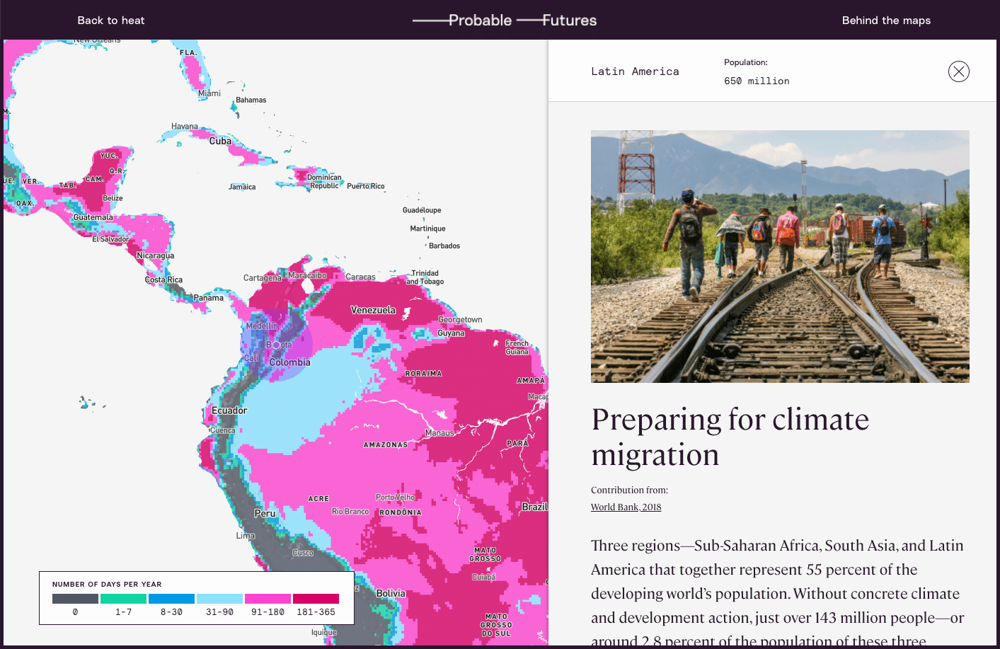
So, working with scientists and communicators from Woodwell, Dr. Glendon devised Probable Futures—a website that would offer tools and resources to help the public understand climate change in a way that makes it meaningful to everybody. The site employs well-established models to map changing temperatures, precipitation levels, and drought through escalating potential warming scenarios. The data is coupled with accessible content on the fundamentals of climate science and examples of it playing out in today’s world.
According to the initiative’s Executive Director, Alison Smart, Probable Futures is designed to give individuals a gateway into climate science.
“No matter where one might be on their journey to understand climate change, we hope Probable Futures can serve as a trusted resource. This is where you can come to understand the big picture context and the physical limits of our planet, how those systems work, and how they will change as the planet warms,” Smart says.
Storytelling for the future
As the world awakens to the issue of climate change, there is a growing group of individuals who will need to better understand its impacts. Supply chain managers, for example, who are now tasked with figuring out how to get their companies to zero emissions. Or parents, trying to understand how to prepare their kids for the future. Probable Futures provides the tools and encouragement to help anyone ask good questions about climate science.
To that end, the site leans on storytelling that encourages visitors to imagine their lives in the context of a changing world. The maps display forecasts for 1.5, 2, 2.5, and 3 degrees of warming—our most probable futures, with nearly 3 degrees likely by the end of the century on our current trajectory. For the warming we have already surpassed, place-based stories of vulnerable human systems, threatened infrastructure, and disruptions to the natural world, give some sense of the impacts society is already feeling.
According to Isabelle Runde, a Research Assistant with Woodwell’s Risk Program who helped develop the maps and data visualizations for the Probable Futures site, encouraging imagination is what sets the initiative apart from other forms of climate communication.
“The imagination piece has been missing in communication between the scientific community and the broader public,” Runde says. “Probable Futures provides the framework for people to learn about climate change and enter that place [of imagination], while making it more personal.”
Glendon believes that good storytelling in science communication can have the same kind of impact as well-imagined speculative fiction, which has a history of providing glimpses of the future for society to react against. Glendon uses the example of George Orwell who, by imagining unsettling yet possible worlds, influenced debates around policy and culture for decades. The same could be true for climate communication.
“I’m not sure we need more science fiction about other worlds,” Glendon says. “We need fiction about the future of this world. We need an imaginative application of what we know.” Glendon hopes that the factual information on Probable Futures will spark speculative imaginings that could help push society away from a future we don’t want to see.
For Smart, imagining the future doesn’t mean only painting a picture of how the world could change for the worse. It can also mean sketching out the ways in which humans will react to and shape our new surroundings for the better.
“We acknowledge that there are constraints to how we can live on this planet, and imagining how we live within those constraints can be a really exciting thing,” Smart says. “We may find more community in those worlds. We may find less consumption but more satisfaction in those worlds. We may find more connection to human beings on the other side of the planet. And that’s what makes me the most hopeful.”