Update: How’s U.S. winter weather changing in a warming world?
Cold extremes are indeed waning over most of the midlatitude Northern Hemisphere, but a decade-plus debate on the Arctic’s role continues.

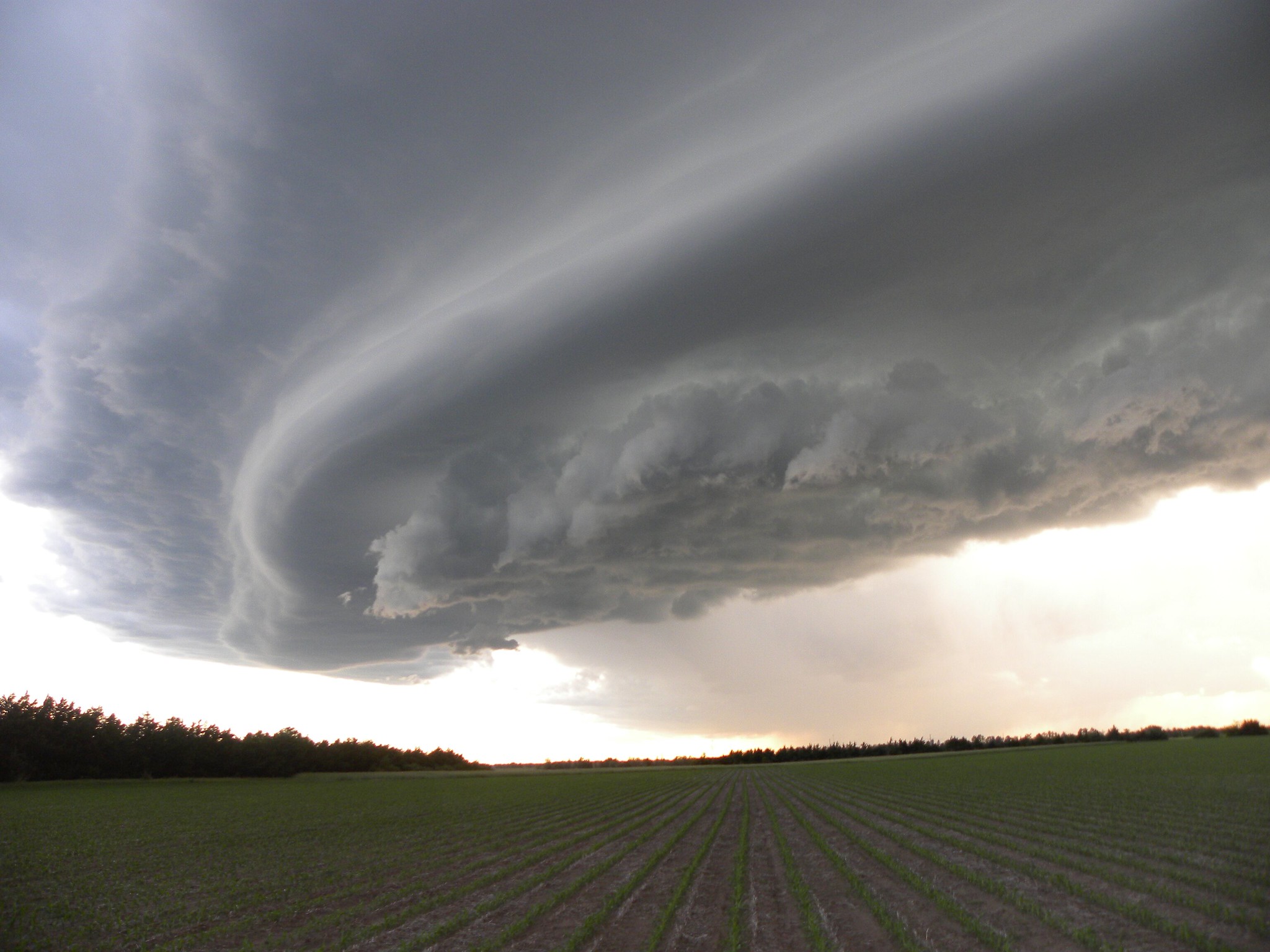
When a full-fledged snowstorm descended on the U.S. Gulf Coast in mid-January 2025, followed by a night of unprecedented cold across some bayous and beaches (see Part I of this two-part post), it did more than turn New Orleans and Mobile into winter wonderlands. It reignited a topic that’s cropped up again and again across science and media landscapes since the early 2010s: Is a warming Arctic affecting winter extremes over North America and Eurasia? And if so, how?
Read more on Yale Climate Connections.
A new study, published in Nature Communications Earth and Environment and co-authored by researchers at Atmospheric and Environmental Research, Inc. (AER) and Woodwell Climate Research Center, finds that abnormally warm temperatures in the Arctic are associated with a higher likelihood of severe winter weather including cold-air outbreaks and heavy snowfall in Northern Hemisphere continents.
“When the Arctic atmosphere is warmer than normal, we see a much higher likelihood of extreme winter weather across much of Canada, the northern U.S. and northern Eurasia,” remarked lead author, Dr. Judah Cohen at AER. “The relationship is especially strong in the northeastern sections of the continents.”
“Even though we’re seeing cold records being broken less often as the globe warms, we’ll still see debilitating spells of severe winter weather,” added co-author Dr. Jennifer Francis at Woodwell Climate. “There will be plenty of ice, snow, and frigid air in the Arctic winter for decades to come, and that cold can be displaced southward into heavily populated regions during Arctic heat waves.”
Recent disruptive extreme winter weather events—such as the deadly Texas cold spell of February 2021—have occurred and will continue to occur in the future, wreaking havoc on infrastructure, human wellbeing, and ecosystems, especially in areas unaccustomed to and ill-equipped for dealing with winter extremes.
“The Arctic may seem irrelevant and far away to most folks, but our findings say the profound changes there are affecting billions of people around the Northern Hemisphere,” added Dr. Francis. To reverse these trends, “it will take bold and rapid actions to reduce our burning of fossil fuels and the build-up of heat-trapping gasses in the atmosphere, but the tools exist if we can muster the will.”
According to Francis, recent studies have theorized that rapid Arctic warming, a pace three-to-four times faster than the globe as a whole, may increase the likelihood of extreme weather events owing to a reduced north/south temperature difference. In addition, slower westerly winds of the jet stream lead to more frequent convoluted jet-stream configurations, which lead to unusual weather.
“Disruptions in the typically stable stratospheric polar vortex may also occur more often in a warming climate,” noted Cohen, “and we know hazardous winter weather is more likely during these disruptions.”
Hurricane season in North America is underway. Already, the second storm of the year to earn a name, Beryl, has cut a destructive swath across the Caribbean and the United States. This year, the National Oceanic and Atmospheric Administration (NOAA) forecasted an extremely active hurricane season, anticipating between 17-25 named storms (the average is 14) and 4-7 major storms (average is 3). Major storms are category 3 and above with wind speeds exceeding 111 mph.
Intense seasons like this are likely to be a more common occurrence in a warmer world, as higher temperatures, rising seas, and changing weather patterns create the conditions for bigger, more destructive, longer lived, and more rapidly strengthening storms. Here’s how climate change is affecting the Atlantic hurricane season:
1. Higher temperatures mean more energy to form hurricanes
To understand how hurricanes are being affected by climate change, it’s important to understand how hurricanes are formed. They are essentially clusters of thunderstorms, building strength as they sweep westward using the energy from warm tropical waters. Under the right conditions, the Earth’s rotation will cause the cluster to spin into a cyclone shape. Because heat is energy, increases in sea surface temperatures play a critical role in strengthening these storms.
The ocean is a major heat sink for the planet, absorbing over 90% of the excess heat trapped by greenhouse gasses in the Earth’s atmosphere over the past few decades. Global sea surface temperatures have increased approximately 2.8F since the beginning of the 20th century, and ocean heatwaves — large areas of above-normal temperatures that can last for months-– are much more common and widespread. A hotter ocean means there is more energy available to fuel tropical storms, ultimately making it a more destructive event when it hits land.
2. The hotter the air, the more water it can hold
The second thing a hurricane needs to form is moisture. Water is evaporated and pulled up into the developing storm as it spins across warm waters of the tropical Atlantic. Hotter air temperatures mean more moisture can be held as vapor in the atmosphere, which allows storms to ingest greater amounts of water that will eventually condense into clouds and be released as rainfall. Condensation also releases heat into the storm, fueling its intensification. Models estimate that human-caused global warming has increased hurricane extreme hourly rainfall rates by 11%.
3. ENSO fluctuations are becoming more extreme
Climate change is also contributing to larger swings between the two phases of the El Niño Southern Oscillation (ENSO)—meaning stronger versions of both El Niño or La Niña patterns. Currently, the Atlantic is headed towards a La Niña, which favors hurricane formation because it lessens vertical wind shear. Differences in wind speeds at different heights in the atmosphere can tear a storm apart, while less shear (more consistency in wind speeds between altitudes) allows storms to stay together and build strength.
4. Tropical storms are undergoing rapid intensification more frequently
All these factors add up to more intense tropical storms in a world altered by climate change— meaning more category 3-5 storms and more big storms back-to-back. Since 1975 the number of category 4-5 cyclones has roughly doubled.
This doesn’t necessarily mean that there will be more hurricanes; however, the ones that do form can be bigger and cause more damage (on top of the already estimated $2.6 trillion in damages since 1980.) If anything, data shows a slight decrease in the number of storms, moving more slowly along their path, releasing their extreme wind and rain over a single location for longer periods.
5. Rising sea levels are making hurricanes more deadly
Sea level rise due to climate change has also made hurricanes a more dangerous threat for more people. As sea levels rise, coastlines are put at increased risk of flooding.
Sea levels have risen roughly 8 in since the late 19th century, and the rate of rise is accelerating as climate change worsens. When a hurricane makes landfall, water is pushed inland by high-speed winds in an event known as storm surge. Every additional inch of sea level rise allows the surge to travel farther inland, threatening a wider area and causing more damage, death, and injury— especially in areas where human development along the coast has exposed people and homes to greater risk.
As temperatures continue to rise, communities along the East and Gulf coasts can expect to be hit harder by destructive storms. Despite this, more and more people are choosing to live and build along the coasts, increasing the cost of damages when hurricanes do strike. Slowing warming temperatures and building adaptation measures to protect coastal communities will become more urgent as Atlantic hurricanes intensify.
The rapid warming of the Arctic has caused substantial sea-ice melt, increased ice-free area, and enhanced evaporation from Arctic Marginal Seas (AMS). According to a recent study, the resulting increased atmospheric moisture and latent energy have profound implications for precipitation patterns over Northern Hemisphere land areas.
During the cold season (October to March) from 1980 to 2021, the sea-ice area in AMS declined by nearly 30% (approximately 2 million square kilometers), accounting for 32% of the increase in AMS-sourced precipitation on lands in the Northern Hemisphere land. This means that for every one million square kilometers of ice loss there was a 16% increase in the contribution of water evaporated from AMS to precipitation over land.
“The study reveals that the enhanced moisture supply has a surprisingly pronounced impact on high-latitude land precipitation,” stated the corresponding author, Dr. Qiuhong Tang. Despite AMS-sourced moisture accounting for only 8% of the total high-latitude land precipitation, its dramatic increase owing to ice loss contributed 42% to the overall precipitation increase. “This additional moisture has also contributed to increased extreme snowfall in high-latitude land areas,” added the lead author and Ph.D. candidate Yubo Liu, “which could help mitigate the impact of climate warming on melting of the Greenland ice sheet.”
“Our findings highlight the important contribution of Arctic sea-ice retreat to Northern Hemisphere land precipitation through moisture cycling, which underscores the many impacts of rapid Arctic change on the global climate system,” added co-author Dr. Jennifer A. Francis. “These insights help inform decision-makers striving to manage impacts of the climate crisis.”
We can all agree 2023 was a weird year for weather, right? The United States set a record for the number of billion dollar weather disasters. A major Amazon River tributary reached its lowest water levels in a century during extreme drought. Extreme rain in Libya caused two dams to break, destroying homes and killing over 4,000 people.
And then, of course, there was the heat. 2023 was the hottest year on record. Countries around the world saw heat records fall month after month. The Arctic was hot. The ocean was hot. And debates swirl on about whether we’ve already passed critical warming thresholds.
So how do we put 2023 in context of the greater trend of warming? Here’s what some of Woodwell Climate’s scientists have to say about last year’s record-breaking events.
Did the models predict this?
The dramatic scenes of heat and extreme weather last year prompted many to ask why temperatures had seemingly spiked way above the trend line. Was this unexpected? Was it out of the range of what scientists had modeled? Woodwell Senior Scientist, Dr. Jennifer Francis says not entirely.
“Almost exactly a year ago,” says Francis, “we had just come out of three years of La Niñas and we came close to breaking global temperature records then, even though La Niñas tend to be cooler than neutral or El Niño years. And then along came the strong El Niño of 2023.”
El Niño and La Niña are two extremes of a natural phenomenon that impacts weather patterns across the Pacific, and around the world. In an El Niño year, the prevailing trade winds that normally push warmer waters into the western tropical Pacific—allowing cooler water to well up along the western coast of the Americas—are reversed, resulting in hotter ocean surface temperatures in the eastern equatorial Pacific. When the ocean is hotter than the air above it, that heat is released into the atmosphere, often making El Niño years record breaking ones for global temperatures.
“Last year’s spike looks a lot like the last big El Niño event in 2015-2016. It’s just that now the whole system is warmer. So to me, it wasn’t at all a surprise that we smashed the global temperature record in 2023,” says Francis.
The spike put global temperatures far above the average of climate model simulations, but that doesn’t mean the models didn’t account for it. Risk Program Associate Director, Dr. Zach Zobel, says that averages tend to smooth out natural year-to-year fluctuations, when in fact the upper and lower ranges of model predictions do encompass temperatures like the ones seen in 2023.
“It was well within the margin of error that you would expect for natural variations,” says Zobel.
How does ocean heat impact the climate?
One element of last year’s heat, one that wasn’t necessarily forecasted, was the simultaneous appearance of several ocean heat waves around the globe. The ocean absorbs the vast majority of heat trapped by greenhouse gasses, and that heat can be released under the right conditions. El Niño is one example, but in 2023 it coincided with other not-so-natural marine heat waves across the world.
“In pretty much every single ocean right now there are heat waves happening, which is something quite new,” says Francis.
A couple of dynamics could be driving this. One possibility is that, after three years of La Niñas, in which equatorial Pacific ocean temperatures were generally cooler than the air, the ocean simply absorbed a lot of heat, which was then primed to be released in an El Niño year. Another, Zobel suggests, could be recent shipping laws that required shipping vessels to eliminate sulfate emissions by 2023. Sulfates are a pollutant that may have been helping bounce back solar radiation, hiding the true extent of warming.
“Usually when there’s an El Niño, the eastern tropical Pacific is very warm, but it doesn’t actually drive up ocean temperatures everywhere,” says Zobel. “That was the biggest surprise to me: how warm the northern hemisphere of the Atlantic and Pacific were for most of last year and into 2024.”
Ocean heat waves are typically long-lived phenomena, lasting many months, and so can be a useful tool for meteorologists looking to predict 2024’s extreme weather events.
“The good news is that it provides some kind of long-term predictability about weather patterns in the upcoming year,” says Francis. “The bad news is that they tend to be unusual weather patterns, because those ocean heat waves aren’t usually there.”
Will next year be hotter?
So are we in for another, hotter year after this one? Risk Program Director Dr. Christopher Schwalm says it’s likely.
“Warming predictions for 2024 from leading scientists all forecast a higher level of warming this year than last year,” says Schwalm.
Already, March 2024, was the 10th month in a row to break temperature records. Zobel says it’s typical for the year following an El Niño peak to maintain high temperatures.
“Because the ocean spent a good amount of the year last year warmer than average, that energy is typically dispersed throughout the globe in the following year,” says Zobel. “So even though the tropical Pacific might return to normal, that energy is still in the system.”
However, atmospheric scientists are already seeing signs that El Niño is slowing down and flipping to its counterpart, La Niña, adding another layer of complexity to predictions for 2024.
“The 2024 hurricane season is a large concern,” says Zobel. “La Niña is a lot more conducive to tropical cyclone development. If we combine above average numbers with the amount of energy that storms have to feed on, it’ll be a shock to the system.”
What does this mean for 1.5?
In the discussions around 2023’s temperatures, one number dominates the conversation: 1.5 degrees C. This is the amount of warming countries around the world agreed to try to avoid surpassing, in accordance with the United Nations’ 2015 Paris Climate Agreement. Estimates from Berkeley Earth say that 2023 may have been the first year spent above that threshold.
This assertion may take several years to verify— one year spent physically above 1.5 degrees of warming does not indicate the UN threshold has been permanently passed. What scientists are looking for is a clear average trend line rising above 1.5 degrees C without coming back down, and for that you need several years of data. That, regrettably, creates a lag time between climate impacts and updating climate policy. But, for many, the debate around the arbitrary 1.5 degree goal has become a distraction. Schwalm says scientists and policy-makers should be focusing on urgently combating climate change whatever the numbers say.
“We are already living in a post-Paris Agreement reality,” says Schwalm. “The sooner we admit that and reimagine climate policy, the better.”
“Actual real world impacts are going to be there, whether we’re at 1.48 or 1.52,” says Zobel.
And Francis agrees. “There are so many indicators telling us that big changes are underfoot, that we are experiencing major climate change, but reaching 1.5 isn’t going to all of a sudden make those things worse. It’s just one more reminder we’re still on the wrong track and we’d better hurry up and do something.”
A sudden flip in weather conditions—from a long hot and dry period to a parade of storms, for example, or from abnormally mild winter temperatures to extreme cold—can cause major disruptions to human activities, energy supplies, agriculture, and ecosystems. These shifts, dubbed “weather whiplash” events, are challenging to measure and define because of a lack of consistent definition. A new study demonstrates an approach to measuring the frequency of these events based on rapid changes in continent-wide weather regimes.
The study indicates that, while the frequency of whiplash events in recent decades has not changed substantially, future model projections indicate increases will occur as the globe continues to warm under a thicker blanket of greenhouse gasses. In particular, the researchers find whiplash will increase most during times when the Arctic is abnormally warm, and decrease when the Arctic is in a cold regime—something that will occur less often as the planet warms.
Examples of weather whiplash during 2022 so far include a long, hot, drought in western U.S. states during early summer that was broken by record-breaking flash flooding; exceptionally wet and cool conditions during June in the Pacific Northwest replaced by a heat wave in July; a record-warm early winter for most south-central states followed by a cooler-than-average January and February; and a spell of 67 consecutive hot, dry days in Dallas, TX, broken by the heaviest rains in a century.
“The spring and summer of 2022 have been plagued by weather whiplash events,” said lead author, Dr. Jennifer Francis, Senior Scientist at the Woodwell Climate Research Center. “A warming planet increases the likelihood of longer, more intense droughts and heat waves, and we’re also seeing these spells broken suddenly by heavy bouts of precipitation, which are also fueled by the climate crisis. These sudden shifts are highly disruptive to all sorts of human activities and wildlife, and our study indicates they’ll occur more frequently as we continue to burn fossil fuels and clear-cut forests, causing greenhouse gas concentrations to rise further.”
Co-author Judah Cohen, Principal Scientist at Verisk AER noted that these phenomena are tightly linked to regional warming in the Arctic.
“We know the Arctic region is experiencing the most rapid changes in the global climate system. Evidence is growing that these profound changes are contributing to more extreme weather events outside the Arctic, and this influence will only increase in the future,” said Dr. Cohen.