2023 was a weird weather year, wasn’t it?
Climate scientists weigh in on what 2023’s record breaking temperatures say about climate models
The El Niño phenomenon can be seen in sea surface temperature patterns in the Pacific Ocean.
map by Greg Fiske
We can all agree 2023 was a weird year for weather, right? The United States set a record for the number of billion dollar weather disasters. A major Amazon River tributary reached its lowest water levels in a century during extreme drought. Extreme rain in Libya caused two dams to break, destroying homes and killing over 4,000 people.
And then, of course, there was the heat. 2023 was the hottest year on record. Countries around the world saw heat records fall month after month. The Arctic was hot. The ocean was hot. And debates swirl on about whether we’ve already passed critical warming thresholds.
So how do we put 2023 in context of the greater trend of warming? Here’s what some of Woodwell Climate’s scientists have to say about last year’s record-breaking events.
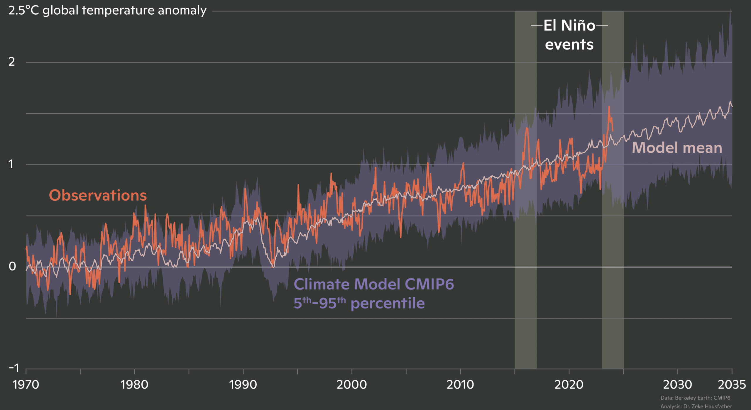
Did the models predict this?
The dramatic scenes of heat and extreme weather last year prompted many to ask why temperatures had seemingly spiked way above the trend line. Was this unexpected? Was it out of the range of what scientists had modeled? Woodwell Senior Scientist, Dr. Jennifer Francis says not entirely.
“Almost exactly a year ago,” says Francis, “we had just come out of three years of La Niñas and we came close to breaking global temperature records then, even though La Niñas tend to be cooler than neutral or El Niño years. And then along came the strong El Niño of 2023.”
animation by Greg Fiske
El Niño and La Niña are two extremes of a natural phenomenon that impacts weather patterns across the Pacific, and around the world. In an El Niño year, the prevailing trade winds that normally push warmer waters into the western tropical Pacific—allowing cooler water to well up along the western coast of the Americas—are reversed, resulting in hotter ocean surface temperatures in the eastern equatorial Pacific. When the ocean is hotter than the air above it, that heat is released into the atmosphere, often making El Niño years record breaking ones for global temperatures.
“Last year’s spike looks a lot like the last big El Niño event in 2015-2016. It’s just that now the whole system is warmer. So to me, it wasn’t at all a surprise that we smashed the global temperature record in 2023,” says Francis.
The spike put global temperatures far above the average of climate model simulations, but that doesn’t mean the models didn’t account for it. Risk Program Associate Director, Dr. Zach Zobel, says that averages tend to smooth out natural year-to-year fluctuations, when in fact the upper and lower ranges of model predictions do encompass temperatures like the ones seen in 2023.
“It was well within the margin of error that you would expect for natural variations,” says Zobel.
graphic by Christina Shintani
How does ocean heat impact the climate?
One element of last year’s heat, one that wasn’t necessarily forecasted, was the simultaneous appearance of several ocean heat waves around the globe. The ocean absorbs the vast majority of heat trapped by greenhouse gasses, and that heat can be released under the right conditions. El Niño is one example, but in 2023 it coincided with other not-so-natural marine heat waves across the world.
“In pretty much every single ocean right now there are heat waves happening, which is something quite new,” says Francis.
A couple of dynamics could be driving this. One possibility is that, after three years of La Niñas, in which equatorial Pacific ocean temperatures were generally cooler than the air, the ocean simply absorbed a lot of heat, which was then primed to be released in an El Niño year. Another, Zobel suggests, could be recent shipping laws that required shipping vessels to eliminate sulfate emissions by 2023. Sulfates are a pollutant that may have been helping bounce back solar radiation, hiding the true extent of warming.
“Usually when there’s an El Niño, the eastern tropical Pacific is very warm, but it doesn’t actually drive up ocean temperatures everywhere,” says Zobel. “That was the biggest surprise to me: how warm the northern hemisphere of the Atlantic and Pacific were for most of last year and into 2024.”
Ocean heat waves are typically long-lived phenomena, lasting many months, and so can be a useful tool for meteorologists looking to predict 2024’s extreme weather events.
“The good news is that it provides some kind of long-term predictability about weather patterns in the upcoming year,” says Francis. “The bad news is that they tend to be unusual weather patterns, because those ocean heat waves aren’t usually there.”
Will next year be hotter?
So are we in for another, hotter year after this one? Risk Program Director Dr. Christopher Schwalm says it’s likely.
“Warming predictions for 2024 from leading scientists all forecast a higher level of warming this year than last year,” says Schwalm.
Already, March 2024, was the 10th month in a row to break temperature records. Zobel says it’s typical for the year following an El Niño peak to maintain high temperatures.
“Because the ocean spent a good amount of the year last year warmer than average, that energy is typically dispersed throughout the globe in the following year,” says Zobel. “So even though the tropical Pacific might return to normal, that energy is still in the system.”
However, atmospheric scientists are already seeing signs that El Niño is slowing down and flipping to its counterpart, La Niña, adding another layer of complexity to predictions for 2024.
“The 2024 hurricane season is a large concern,” says Zobel. “La Niña is a lot more conducive to tropical cyclone development. If we combine above average numbers with the amount of energy that storms have to feed on, it’ll be a shock to the system.”

Hurricane Idalia in August 2023 flooded much of the city of St. Petersburg, FL. Meteorologists are concerned about the potential for destructive hurricanes in 2024.
photo courtesy of the City of St. Petersburg/ Flickr
What does this mean for 1.5?
In the discussions around 2023’s temperatures, one number dominates the conversation: 1.5 degrees C. This is the amount of warming countries around the world agreed to try to avoid surpassing, in accordance with the United Nations’ 2015 Paris Climate Agreement. Estimates from Berkeley Earth say that 2023 may have been the first year spent above that threshold.
This assertion may take several years to verify—one year spent physically above 1.5 degrees of warming does not indicate the UN threshold has been permanently passed. What scientists are looking for is a clear average trend line rising above 1.5 degrees C without coming back down, and for that you need several years of data. That, regrettably, creates a lag time between climate impacts and updating climate policy. But, for many, the debate around the arbitrary 1.5 degree goal has become a distraction. Schwalm says scientists and policy-makers should be focusing on urgently combating climate change whatever the numbers say.
“We are already living in a post-Paris Agreement reality,” says Schwalm. “The sooner we admit that and reimagine climate policy, the better.”
“Actual real world impacts are going to be there, whether we’re at 1.48 or 1.52,” says Zobel.
And Francis agrees. “There are so many indicators telling us that big changes are underfoot, that we are experiencing major climate change, but reaching 1.5 isn’t going to all of a sudden make those things worse. It’s just one more reminder we’re still on the wrong track and we’d better hurry up and do something.”