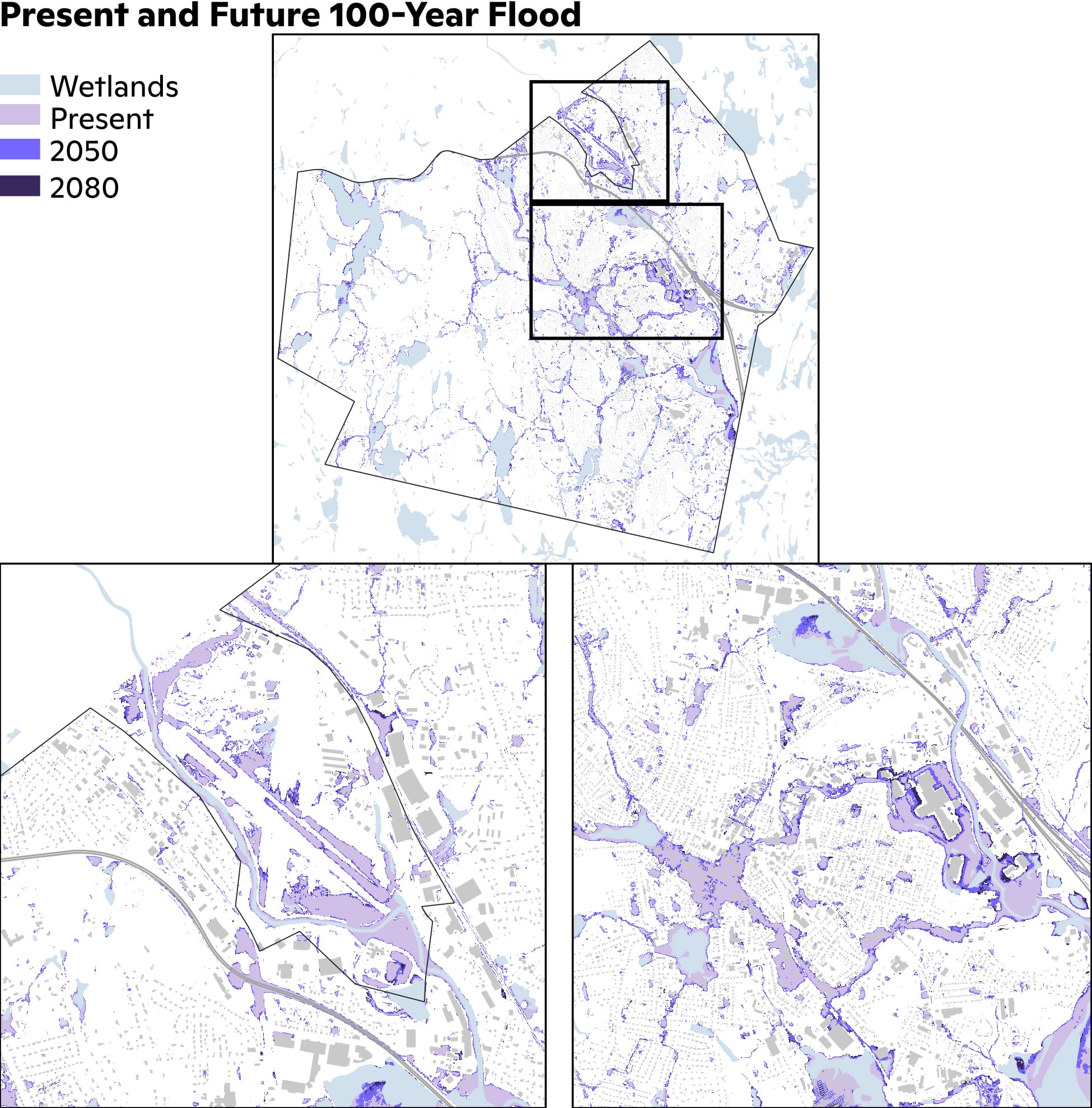
Climate Risk Assessment: Leominster, Massachusetts

Aerial view of a city section, photo by Nick Allen, CC BY-SA 4.0

photo by Nick Allen, CC BY-SA 4.0

 
Download the assessment

New Bedford, MA climate risk assessment cover

Introduction

The impacts of climate change on the frequency and severity of physical hazards are putting many communities at risk. As the threat of climate change grows, so too does the need for accessible information, tools, and expertise to support climate-resilient decision making across multiple scales, from communities to countries. Woodwell Climate Research Center believes there is a need to localize and customize climate risk assessments. This information is critical for local government leaders as they make planning decisions, but it is not available to all communities. Woodwell believes that this science should be freely and widely available. To address this gap, Woodwell works with communities across the world, including Leominster, MA, to provide community climate risk assessments, free of charge.

Research area

Results summary

As a result of climate change, flood risk is projected to increase for Leominster. The probability of the historical 100-year rainfall event, a useful indicator of flood risk, is expected to almost triple by mid-century and be more than five times as likely by the end of the century. Streamflow for the North Nashua River is also estimated to rise throughout this century with an increase of 12.2% by 2050 and an additional 12.5% by 2080. Both increases in streamflow and heavier rainfall will translate into greater flood depths and extent for Leominster. The vulnerability of Leominster’s stormwater system was evaluated under the present and future 100-year rainfall event. Here we present our findings on extreme precipitation and flooding to help Leominster in its plans to create a more resilient future for all residents.

Extreme rainfall

The Fifth National Climate Assessment shows that the U.S. Northeast region has already seen a 60% increase in annual precipitation since the 1950s, the largest in the U.S., occurring from the heaviest 1% of events.1 Future warming is expected to continue this trend of intensification, meaning more frequent and severe rainfall events. Here we use localized future precipitation data from downscaled global climate models to calculate the change in probability of extreme rainfall events. A detailed explanation of the precipitation data processing can be found in the methodology section of this document.In Table 1, we show the changes in the return period of the present-day (2000–2020) 100-year rainfall event for mid-century (2040–2060) and late-century (2070–2090). By mid-century, the present-day 100-year event will occur with a return period of 1-in-37. By late-century, the present-day 100-year event will become a 1-in-19 year event.

According to the National Atlas 14 published by the National Oceanic and Atmospheric Administration (NOAA), the 100-year rainfall amount, based on present-day rainfall records, for Leominster is 7.3 inches (185 mm).2 For reference, the present-day annual average rainfall for Leominster is 45.2 inches (1148 mm).3 By mid-century, the 100-year amount will increase to 8.8 inches (224 mm) and by late-century this will further rise to 10.4 inches (264 mm; Table 1).

Present 2040-2060 2070-2090
Return Period (yr) 1-in-100 1-in-37 1-in-19
100-Year 7.3 in (185 mm) 8.8 in (224 mm) 10.4 in (264 mm)
Table 1: Mid and Late-21st Century Change in Historical 100-Year Return Period and Rainfall. The mean future return period in years and rainfall amounts in inches and millimeters for Leominster of the present-day, 2040–2060, and 2070–2090 100-year rainfall events.

Flooding

For a detailed explanation of the flood model input data and flood modeling procedures, please refer to the methodology section of this document.

Flood extent comparison

Before estimating future flood risk, we compare the present-day flood risk results against the Federal Emergency Management Agency (FEMA) flood maps as a validation exercise. FEMA maps are not ground truth data, but it is useful to compare various model results given the lack of appropriate reference data. Figure 1 shows the differences and similarities between FEMA’s estimate and Woodwell’s estimate of the 100-year flood extent for the Leominster, MA region. Areas where only FEMA predicts flood risk are shown in green, areas where only Woodwell predicts flood risk are shown in red, and areas where both predict flood risk are shown in purple. Several patterns emerge when comparing the extents visually. The risk along the Nashua River estimated by FEMA is greater than Woodwell estimates in some locations, in particular the Fitchburg Regional Airport and to a lesser extent just south of the airport along Highway 2 and further south near the Leominster Connector. The higher estimate by FEMA has previously been documented in Evaluation of Flood Plain of North Nashua River Adjacent to Fitchburg Easterly Wastewater Treatment Facility by Wright-Pierce. Their research indicated that the 100-year streamflow value used in the flood insurance studies was highly overestimated. The original FEMA maps only used one gauge near the southern boundary of Leominster. A second gauge was added upstream of Leominster but it did not have enough data to be used in the FEMA maps. As more data has been collected, it was discovered the 1936 flood of record was actually a 200-year event, but the 100-year streamflow values used by FEMA exceeded this 1936 event. The most recent FEMA report has updated the streamflow values4; however the flood zones outside of the Fitchburg Easterly Wastewater Treatment Facility have not been updated. Further information can be found in the streamflow methodology section. Finally, FEMA shows no flood risk from pluvial (rainfall-induced) flooding, while Woodwell demonstrates extensive pluvial areas are vulnerable to flooding such as between Highway 12 (Central Street) and Mechanic Street/Leominster Connector. This is because FEMA does not account for pluvial flooding.

Woodwell vs FEMA 100-Year Flood maps comparison

Figure 1: Woodwell vs FEMA 100-Year Flood. The flood extent comparison between Woodwell’s flood model results and the current FEMA flood maps for Leominster, MA. Areas where only FEMA predicts flood risk are shown in green, areas where only Woodwell predicts flood risk are shown in red, and areas where both predict flood risk are shown in purple. The Woodwell data shows the maximum extent based on both the 100-year pluvial/riverine floods. Areas boxed in the top map are shown at the zoomed in level in the bottom two panels. The bottom left panel shows the Fitchburg Regional Airport and the bottom right map is downstream of Rockwell Pond over to Whitney Field Mall.

Present and Future Flood Risk

The primary flood risk in Leominster, MA, is pluvial flooding. In Figure 2, we show the extent of the 100-year flood from both streamflow and rainfall for Leominster. Pluvial flooding risk exists downstream of Rockwell Pond along Monoosnoc Brook. Peak flood amounts in this area near the brook exceed 6.6 ft (2m) while the surrounding area ranges from 1.6 ft to 3.3 ft (0.5m–1m). Flooding around Whitney Field Mall and Commercial Road is also substantial, with similar values of up to 3.3 ft (1m). Commercial Road along Whitney Field Mall was flooded during the September 2023 heavy rainfall event as well.5 While outside the city limits of Leominster, the Fitchburg Municipal Airport was included in this study due to its regional influence. While we show less flooding than FEMA, the airport is still substantially flooded and should be taken into account for future planning. We mask wetland areas to focus the analysis on locations where human life and property are at risk.

Present-Day 100-Year Flood maps

Figure 2: Present-Day 100-Year Flood. The flood extent, quantified as having a depth of at least 0.5 ft (0.15 m), for Leominster, MA. The maximum extent from the 100-year pluvial/riverine flood is shown. Areas boxed in the top map are shown at the zoomed in level in the bottom two panels. The bottom left panel shows the Fitchburg Regional Airport and the bottom right map is downstream of Rockwell Pond over to Whitney Field Mall.

Future flood risk is primarily driven by increased rainfall and not from increased streamflow along the North Nashua River. The largest changes in extent, highlighted in Figure 3, are downstream of Rockwell Pond along the Monoosnoc Brook (this is purely from rainfall and not streamflow) and Whitney Field Mall. This change in pluvial flood risk is due to projected increases in rainfall between 1.5 inches to 3.1 inches (38–69 mm) from the present-day period, as shown in Table 1. The riverine flood extent is impacted by an increase of streamflow (12.2% increase by 2050 and an additional 12.5% by 2080)6 on the North Nashua River. We also present several flood risk metrics in Table 2. Presently, 9.5% of the structures in Leominster are vulnerable to the 100-year rainfall or streamflow event. That number increases to just over 10% by mid-century and then to just over 11% by late-century. The average flood depth in Leominster has a minor increase of 0.4 ft (0.12 meters) through the 21st century, while the area flooded increases by about 275 acres by late-century, representing roughly a 1.5% increase in area flooded.

Present-Day and Future 100-Year Flood

Figure 3: Present-Day and Future 100-Year Flood. The flood extent, quantified as having a depth of at least 0.5 ft (0.15 m), for Leominster, MA. The maximum extent for the 100-year pluvial/riverine flood is shown. Areas with increased future extent are boxed in the top map, and the bottom left panel shows the Fitchburg Regional Airport and the bottom right map is downstream of Rockwell Pond over to Whitney Field Mall.
Present 2040-2060 2070-2090
Area Flooded 1,193 acres (6.7%) 1,345 acres (7.6%) 1,470 acres (8.3%)
Average Depth 2.5 ft (0.76 m) 2.7 ft (0.82 m) 2.9 ft (0.88 m)
Structures Flooded 1,417 (9.5%) 1,536 (10.3%) 1,651 (11.1%)
Table 2: Flood Risk Metrics for Mid and Late-21st Century in Leominster. The acres of land area (excluding wetlands; and percent of total non-wetland area) flooded and the number of buildings (and percent of total structures) flooded for Leominster of the present-day, 2040–2060, and 2070–2090 100-year rainfall and streamflow events.

Stormwater System Vulnerability

In addition to flood extents, an analysis of the flood model results for the Leominster stormwater system was conducted to identify bottlenecks in the system. Any manholes or catch basins (sometimes referred to as drainage basins) that overflowed during the simulation were considered flooded. Conduits (pipes) that are capacity-limited (also referred to as at-capacity) were also identified. Capacity-limited is defined as when flow entering the pipe is greater than what the conduit can convey. We show capacity-limited pipes to identify any pipes that may be undersized or undersloped. These pipes may be responsible for causing flooding or upstream backwater conditions to occur at manholes or catch basins. Such pipes would be good starting points when investigating where to perform stormwater system upgrades.

Leominster’s stormwater system shows high spatial distribution in the hot spots of vulnerability to the 100-year rainfall event. In Table 3, we show the number and percentage of manholes and catch basins flooded and capacity-limited conduits for the present-day, 2040–2060, and 2070–2090 100-year events. In Figure 4, we show the locations of concentrations of manholes and catch basins flooded as a heat map, as well as which conduits are capacity-limited. During the present-day 100-year rainfall event, 50.8% of all conduits in Leominster’s stormwater system are capacity-limited. From the present to the late-21st century, the number of capacity-limited conduits will increase by 6%. The percentage of manholes and catch basins flooded is smaller compared to the conduits, but a similar upward trend is expected, with 33.9% of the catch basins and 21.2% of the manholes flooded by the late-21st century. The difference in proportion of manholes/catch basins flooded and conduits at-capacity indicates that the stormwater system is able to reduce street flooding even when the stormwater pipes are filled. We identified several hot spots of stormwater flooding throughout Leominster. These include along Monoosnoc Brook downstream of Rockwell Pond, the intersection of Highway 2 and 12, and the area around the Whitney Field Mall.

It is important to note that we show all conduits that are capacity-limited regardless of the duration they were capacity-limited during the simulation. The vast majority of conduits in the present time period that were at-capacity (67.7%) spent only 36 seconds
in a limited flow state. We include these conduits in the flooding metrics to give a system-wide perspective on the capacity of the stormwater system.

Leominster Stormwater System Flooding Heat Map

Figure 4: Leominster Stormwater System Flooding Heat Map. The concentration of flooded manholes and catch basins shown as a heat map for the present-day 100-year rainfall event. Areas with no flooded manholes or catch basins are shown in white. Capacity-limited conduits are shown in black. Areas boxed in the top map are shown at the zoomed-in level in the bottom two panels. The bottom left panel shows the area just southwest of the Fitchburg Regional Airport, while the bottom right is downstream of Rockwell Pond over to Whitney Field Mall.
Present 2040-2060 2070-2090
Manholes 630 (16.6%) 735 (19.3%) 807 (21.2%)
Catch Basins 1,538 (25.9%) 1,815 (30.6%) 2,014 (33.9%)
Conduits 5,481 (50.8%) 5,853 (54.2%) 6,143 (56.9%)
Table 3: Leominster Stormwater System Flooding. The number, and percentage of total, flooded manholes and catch basins and capacity-limited conduits for the present-day, 2040–2060, and 2070–2090 100-year rainfall event.

Conclusion

Leominster is currently at risk from flooding, primarily from rainfall, and this exposure will only increase under climate change. The results presented in this study were compared to FEMA’s flood maps, revealing significant discrepancies primarily due to the exclusion of pluvial flooding in FEMA’s analysis and overestimation of the North Nashua River. Our findings show an expected increase in the frequency and intensity of heavy rainfall with the probability of the present-day 100-year rainfall event to be nearly three times as likely by the mid-21st century and just over five times as likely by the end of the century. Leominster’s stormwater system will also face greater stress as rainfall intensifies with over 21% of manholes and nearly 34% of catch basins flooding by the late-21st century. This report provides insight into the vulnerability of the city of Leominster, where an increasing number of buildings and areas will be exposed to flood waters by the end of the century. Lastly, the 100-year streamflow of the North Nashua River is estimated to increase by 12.2% by 2050 and an additional 12.5% by 2080.

Read the full assessment with methodology section.


1 Marvel et al. (2023). Ch. 2. Climate trends. In: Fifth National Climate Assessment. Crimmins, A.R., C.W. Avery, D.R. Easterling, K.E. Kunkel, B.C. Stewart, and T.K. Maycock, Eds. U.S. Global Change Research Program, Washington, DC, USA. https://doi.org/10.7930/NCA5.2023.CH2

2 NOAA calculates extreme rainfall frequencies with all available station data.

3 The period of record is 1998 through 2025. For more information: https://www.weather.gov/wrh/Climate?wfo=box

4 Flood Insurance Study Worcester County, Massachusetts Volume 2 of 12. Federal Emergency Management Agency. July 8, 2025. Flood Insurance Study Number 25027CV002D

5 Leominster Emergency Flooding: Looking Upstream, Learning Downstream. https://leominsterfloodsolutions-bscgroup.hub.arcgis.com

6 Olson, S.A., Shabestanipour, G., Lamontagne, J., & Steinschneider, S. (2024). Characterizing future streamflows in Massachusetts using stochastic modeling—A pilot study. U.S. Geological Survey Scientific Investigations Report 2023–5134, 19p. https://doi.org/10.3133/sir20235134