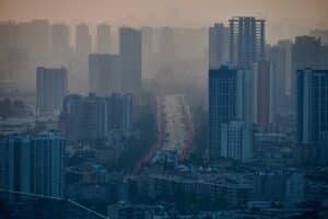
A chapter of the National Oceanic and Atmospheric Administration’s (NOAA) 2024 Arctic Report Card, published today, presents a new, comprehensive pan-Arctic carbon assessment that, when accounting for wildfire emissions, finds that the Arctic tundra has shifted from storing carbon to being a source of carbon emissions to the atmosphere.
While the Arctic has been a carbon “sink” for thousands of years—storing more carbon than it releases—the Arctic Report Card chapter, Arctic Terrestrial Carbon Cycling, explores how rapid Arctic warming is prompting a range of ecosystem changes that are leading to increased emissions throughout the region. Among these are thawing permafrost (perennially frozen ground), wildfires, and plant and microbial changes.
In particular, the assessment, led by scientists at Woodwell Climate Research Center, finds that 2024 marked the second-warmest average yearly permafrost temperatures on record for Alaska, and the second-highest year for wildfire emissions north of the Arctic Circle.
“The Arctic is warming up to four times the global rate, and we need accurate, holistic, and comprehensive knowledge of how climate changes will affect the amount of carbon the Arctic is taking up and storing, and how much it’s releasing back into the atmosphere, in order to effectively address this crisis,” said Dr. Sue Natali, Woodwell Climate scientist, chapter lead and lead of Woodwell Climate’s Permafrost Pathways project. “This report represents a critical step toward quantifying these emissions at scale which is critical for understanding their impacts on global climate and informing equitable mitigation and adaptation strategies.”
“In recent years, we’ve seen how increasing fire activity from climate change threatens both communities and the carbon stored in permafrost, but now we’re beginning to be able to measure the cumulative impact to the atmosphere, and it’s significant,” said Dr. Brendan Rogers, Woodwell Climate scientist, chapter co-author, and co-lead of Woodwell Climate’s Permafrost Pathways project.
“This year’s report demonstrates the urgent need for adaptation as climate conditions quickly change,” said Twila Moon, lead editor of the 2024 Arctic Report Card and deputy lead scientist at the National Snow and Ice Data Center. “Indigenous Knowledge and community-led research programs can inform successful responses to rapid Arctic changes.”
Contributions to the chapter were also made by Woodwell Climate scientists, Dr. Kyle Arndt, Dr. Jacqueline Hung, Greg Fiske, Stefano Potter, and Dr. Anna Virkkala, as well as collaborators at University of Alaska-Fairbanks, Northern Arizona University, and Université de Montréal.
The Arctic Report Card combines the best available research from over 97 scientists from 11 countries, including seven from Woodwell Climate. Its chapters reveal record-setting observations of a rapidly warming Arctic, including rising air temperatures, declines of large inland caribou herds, and increasing precipitation. These climate impacts and others threaten the health, subsistence, and homes of many Indigenous communities living in the Arctic.
The full Arctic Report Card can be read here.
Second-warmest November on record means that 2024 is likely to be Earth’s hottest year, report says

Earth just experienced its second-warmest November on record — second only to 2023 — making it all but certain that 2024 will end as the hottest year ever measured, according to a report Monday by European climate service Copernicus.
Last year was the hottest on record due to human-caused climate change coupled with the effects of an El Nino. But after this summer registered as the hottest on record — Phoenix sweltered through 113 consecutive days with a high temperature of at least 100 degrees Fahrenheit (37.7 Celsius) — scientists were anticipating that 2024 would set a new annual record as well.
Continue reading on AP News.
Some of the world’s biggest cities are so polluted they’re warming slower
But this surprising effect of pollution should hardly be taken as a good sign.
The question of whether global warming is accelerating is hotly contested among climate scientists. While some have argued that the current rate of warming — which hit an all-time high last year — is strictly correlated with increased fossil fuel emissions and therefore aligned with current climate models, others have cautioned that the Earth is far more sensitive to fossil fuels than previously thought and that humanity is hurtling toward tipping points from which there can be no return.
“What if you’re not on the map?”
Dr. Kelsey Leonard of the Shinnecock Indian Nation addressed this question to a room of Geographic Information System (GIS) professionals at Esri’s global mapping conference in 2023. Leonard, who uses maps to advance Indigenous water justice, asks this question to raise awareness about the absence of Indigenous land and languages in GIS tools. The removal of traditional place names in physical spaces, cartographic maps, and geospatial software often contributes to the erasure of Indigenous culture and history.
The Permafrost Pathways project, like Leonard, is working to change that.
Read more on Permafrost Pathways
Under the thick forest of Mexico’s Yucatán Peninsula, the ancient ruins of a Maya City have been uncovered with the use of remote sensing.
Of course, that wasn’t the outcome that Woodwell Climate’s Chief Scientific Officer, Dr. Wayne Walker, anticipated when he and his team collected and processed the remote sensing dataset for an unrelated project nearly a decade ago.
Walker’s team was mapping the region as part of the Mexico REDD+ project, a collaborative, international effort to explore strategies for reducing emissions from deforestation and degradation in the country. Using a remote sensing technology called LiDAR, which scans terrain from a low-flying plane using pulses of laser light, Walker and project collaborators created a comprehensive map of forests—and the carbon they contain—across Mexico.
Walker and team coordinated the flights and processed the raw data for use in the project, uploading it afterwards to a website for public use. But, once the project ended, he all but forgot about the effort, apart from responding occasionally to researchers interested in downloading the dataset for their own work.
One of those researchers was Luke Auld-Thomas, a PhD candidate at Tulane University researching the Classic Maya civilization, which thrived in the Yucatan until the 9th century when much of the region was abandoned, though their culture and languages persist to this day. Because of its unique ability to provide a detailed three-dimensional picture of whatever features are present on the ground, LiDAR imagery is an incredibly powerful tool for a multitude of purposes, from climate science to archaeology. And while the Mexico REDD+ project was interested in documenting the forests, Auld-Thomas was interested in what might be hidden beneath them.
“One scientist’s noise is another’s entire field of study,” says Walker. “In our other projects, like Climate Smart Martha’s Vineyard, we see historical structures like stone walls that aren’t necessarily meaningful to our work but could be of interest to archaeologists.”
In Mexico, the large areas surveyed by Woodwell Climate revealed not just individual human-built structures, but the plazas, reservoirs, and ball courts of an entire, previously undocumented city. The discovery, published in the journal Antiquity, supported the theory that the region was, in fact, densely settled during the height of Classic Maya civilization.
“We knew that it was close to a lot of interesting sites and settlements— areas of large-scale landscape modification that had been mapped and studied— but none of the survey areas themselves were actually places that archeologists ever worked, making it a really exciting sample to work with,” said Auld-Thomas.
Auld-Thomas had specifically been on the hunt for a pre-existing LiDAR dataset like the one Walker helped create— a survey conducted for completely non-archaeological purposes and therefore free of any biases. Essentially a “random sample” of the region. That randomness, and the subsequent discovery of an entire city, allowed Auld-Thomas and his colleagues to more strongly argue their point about intense urbanization in the Yucatán.
“If you’re only going to places where you know there’s going to be something, then of course, you’re going to find something significant, right? These random samples, not collected for archeological purposes, are gold in some respects,” said Dr. Marcello Canuto, who co-authored the paper. Canuto directs the Middle American Research Institute at Tulane, where the research for this study was conducted.
The unexpected outcome of the LiDAR survey offers a textbook example of the value of open data access. Sharing data and resources both within and between fields of science can jumpstart discovery and distribute the costs of an otherwise expensive data collection effort.
“Just look at what came out of the moonshot,” says Canuto. Thousands of technologies, developed in humanity’s pursuit of the moon landing, have found unforeseen applications in today’s world— including LiDAR.
“Certainly, many of us have produced datasets that have led to incremental advances in closely related fields,” says Walker. “But here is a special case of open source data advancing discovery in an entirely unrelated field of study.”
Advancements across fields continue to better our understanding of the world around us. And the lessons learned from a civilization like the Maya have very real parallels to today’s climate crisis.
As Auld-Thomas and Canuto show, the Maya densely settled the Yucatán Peninsula, maxing out the capacity of the surrounding environment to support their population. And then the regional climate shifted. A long-term drought settled in, resources became scarcer, governments became unstable, people started leaving the cities, and the infrastructure of the larger civilization collapsed.
“The reason environmental scientists collect LiDAR data of the forest, is that they are trying to understand environmental processes in order to help human societies conserve the landscape,” says Auld-Thomas. “As archaeologists, we try to understand how people in these exact environmental contexts have confronted deforestation and climate change and all of these other things before.”
For Canuto, the lesson to be learned lies not just in the environmental perils, but in the societal ones. Because what complex societies hate— be they the Classic Maya or today’s modern culture— is a lack of predictability. If a system cannot adapt, it will fail.
“The collapse was more than just climate change,” says Canuto. “It was a failure of a political system to respond to climate change.”
A winter weather puzzle is raising the risk of meteoric energy inflation
A winter forecasting enigma is poised to send prices for energy and food on a bumpy ride in the next few months, with commodities from natural gas to wheat at risk of breakneck gains against a backdrop of geopolitical turmoil.
Earlier in the year, meteorologists expected this December, January and February to be dominated by the La Niña climate pattern, which influences the world’s weather in specific ways. But La Niña has yet to arrive, and if it does, it will probably be weak. That makes the outlook for the northern hemisphere’s winter much more uncertain.
La capitale congolaise Kinshasa s’étend sur la rive sud d’un coude turbulent et boueux du fleuve Congo. C’est ici que Glenn Bush, chercheur associé de Woodwell Climate, et Joseph Zambo, coordinateur des forêts et du changement climatique, ont rejoint d’autres chercheurs et responsables gouvernementaux dans les salles de conférence d’un hôtel du centre-ville pour un atelier de trois jours sur la tourbe.
Glenn Bush est un économiste et spécialiste des sciences sociales qui travaille depuis 16 ans en République démocratique du Congo (RDC), où il étudie les structures sociales et économiques qui déterminent l’utilisation des terres. Zambo est le reponsable de Woodwell Climate en RDC, et assure la liaison entre les résidents locaux, le gouvernement national et les chercheurs internationaux. Ces deux chercheurs se sont engagés à conseiller le gouvernement de RDC afin de l’aider à créer sa « contribution déterminée au niveau national » (CDN), qui définit l’engagement du pays à réduire ses émissions dans le cadre des Nations unies sur le changement climatique.
Les tourbières, un type d’écosystème humide, pourraient constituer un élément essentiel de la contribution de la RDC. Ces sols riches en carbone qui s’étendent sur de vastes surfaces de la forêt tropicale congolaise doivent impérativement être protégés. Des activités telles que l’agriculture, la déforestation et le changement climatique ont cependant déjà commencé à grignoter le précieux stock de carbone. Et une fois libérée, la tourbe prend des millénaires à se renouveler.
Qu’est-ce qu’une tourbière ?
Les tourbières du Congo se trouvent principalement dans les forêts humides et marécageuses dans le « centre du bassin » du Congo. Elles se forment sur les rives humides des cours d’eau – un environnement pauvre en oxygène qui ralentit le processus de décomposition, permettant à la matière organique de s’accumuler au fil du temps pour former un sol spongieux qui emprisonne le carbone, l’empêchant ainsi de rejoindre l’atmosphère.
La stabilité d’une tourbière dépend du taux d’humidité et des matières organiques. En cas d’assèchement d’un marais tourbeux, le carbone en contact avec l’air est immédiatement exposé à la décomposition et à l’érosion.
« Dès que les bactéries aérobies commencent à pénétrer dans la tourbière, explique Bush, tout ce carbone commence alors à devenir instable. Il est donc crucial d’éviter autant que possible de perturber cette tourbe. »
Mais, cette mesure est une action difficile à entreprendre de nos jours. La croissance démographique pousse les populations à s’enfoncer vers des marais boisés, exploités souvent pour l’agriculture, notamment pour la production du riz dans les zones humides ou la pisciculture, afin de subvenir aux besoins de leurs familles et de leurs communautés.
Les tourbières sont également extrêmement sensibles à la dégradation et à la déforestation dans le biome de la forêt tropicale. Au cœur du bassin du Congo, la forêt tropicale est en fait le moteur de la création de la plupart de ses propres pluies – la saison des pluies de printemps est déclenchée par l’humidité insufflée dans l’atmosphère par les plantes, plutôt que par le vent de la mer qui pénètre les terres. Face aux effets desséchants de la déforestation, le Congo est donc encore plus fragile que l’Amazonie.
« Pour chaque hectare de forêt perdu en Afrique, on perd proportionnellement plus de précipitations que pour une quantité similaire de forêt perdue en Amérique latine ou en Asie du Sud et du Sud-Est », explique Dr Mike Coe, directeur du programme Woodwell Climate Tropics.
Ce que nous ne savons pas sur les tourbières du Congo
Quelle est la superficie exacte des tourbières du bassin du Congo ? Et quelle serait la gravité de leur disparition en termes d’émissions ? La réponse à ces deux questions est « nous n’avons aucune donné précise ».
La recherche commence à peine à cartographier cet écosystème critique. Récemment, une équipe de chercheurs congolais et britanniques dirigée par le Dr Simon Lewis de l’université de Leeds a parcouru deux transects de 20 à 30 kilomètres de forêt marécageuse pour prélever des échantillons afin d’évaluer l’existence de tourbières. Ils en ont trouvé partout dans la forêt. Au total, on estime à 145 000 kilomètres carrés la superficie de la région.
Cela représente environ 30 milliards de tonnes de carbone, soit plus de 20 fois les émissions annuelles de combustibles fossiles des États-Unis.
« Il ne s’agit que de deux transects dans l’ensemble du bassin du Congo, mais qui nous ont permis de recalibrer les modèles existants d’étendue et de qualité des tourbières, et cela démontre que nous visitons un trésor de carbone tropical », insiste Bush.
Protéger les tourbières, c’est lutter contre la pauvreté
Protéger les tourbières est crucial, mais dans la pratique, elle est difficile à mettre en œuvre. Pourquoi ?
À l’heure actuelle, les tourbières sont plus utiles pour les congolais en tant que ressources foncières permettant de produire de la nourriture, de chasser, de pêcher et de récolter des plantes et des matériaux de construction, qu’en tant que forêt intacte. Selon certaines estimations, plus de 90 % de la déforestation dans le pays a pour but de soutenir l’agriculture de subsistance. C’est une nécessité pour près des trois quarts de la population du pays qui vit avec moins de 2,15 $ par jour.
En 2020, Zambo et Bush, accompagnés de Kathleen Savage, chercheuse principale à Woodwell, ont mené des études sur les méthodes d’intensification agricole dans les rizières humides, qui sont souvent créées sur des tourbières déboisées. L’application de techniques agricoles différentes, consistant à désherber et à s’occuper des plants de riz tout au long de la saison plutôt que de voyager et de revenir pour la récolte, permettaient un augmentation considérable des rendements sur la même surface, ce qui réduit la nécessité d’augmenter de grignoter la forêt pour augmenter la productivité.
« Rien qu’en s’occupant du riz, on pourrait peut-être sauver environ 30 % de la forêt », explique Savage.
Les agriculteurs ont reconnu les avantages de cette méthode, mais hésitent à l’adopter. En attendant la croissance du riz, le temps est souvent consacré à gagner un revenu supplémentaire pour les charges immédiates. Tabler sur un revenu plus conséquent à la fin de la saison est un risque qu’ils ne veulent pas toujours se permettre. Une bonne récolte n’est pas garantie ; les parasites, la sécheresse ou les inondations peuvent anéantir le travail d’une année, laissant les agriculteurs sans revenu. Cette fragilité pousse les populations à prendre des décisions difficiles quant à l’utilisation des forêts.
« La RDC ne dispose d’aucun filet de sécurité sociale », rappel Savage. « En fait, le filet de sécurité sociale, c’est la forêt – la chasse, l’abattage d’un arbre et la vente du bois parce qu’il vaut beaucoup d’argent. »
Les marchés du carbone pourraient orienter l’argent vers les communautés forestières
Afin d’éviter la déforestation et la dégradation des tourbières, les communautés rurales devront trouver une autre source de revenus. Bush et Zambo ont discuté du potentiel des marchés du carbone pour fournir ces revenus.
Les marchés du carbone sont des systèmes d’échange qui attribuent une valeur monétaire à la prévention de l’émission de carbone dans l’atmosphère ou à son élimination active. Ils fonctionnent sur la base de la vente de « crédits carbone » qui représentent théoriquement une tonne métrique de carbone stockée ou séquestrée grâce à des pratiques de gestion des terres. Idéalement, l’argent provenant de leur achat va directement aux personnes qui gèrent les terres, qu’il s’agisse d’un agriculteur qui protège les forêts ou d’un groupe communautaire qui restaure les zones dégradées.
En réalité, les crédits carbone sont difficiles à vérifier en raison de la faiblesse des réglementations et du manque de données.
« Le problème du crédit carbone est que personne n’est vraiment sûr de la qualité et des normes de livraison, ni de la manière de les mesurer et de les contrôler, car il est évident que quelqu’un ne se présente pas à votre porte avec un sac rempli de carbone », nuance Bush.
Jusqu’à présent, la mise en œuvre du marché a été entravée par des accusations d’écoblanchiment de la part des entreprises polluantes qui achètent des compensations et par des programmes réglementaires gouvernementaux qui peinent à prouver le bénéfice sur le climat et la biodiversité. Bush et Zambo estiment néanmoins qu’une version de cette solution pourrait apporter des revenus plus conséquents directement aux agriculteurs si elle est bien appliquée.
Bush travaille avec l’équipe carbone de Woodwell Climate à l’élaboration d’un indice de capital paysager (ICP) qui utilise des normes scientifiques pour évaluer le potentiel de toute parcelle de terre à atténuer les effets du changement climatique et à offrir d’autres avantages tels que la biodiversité et le cycle de l’eau. Une fois affiné, l’indice fournira des données permettant de vérifier les crédits carbones.
Zambo s’est beaucoup a mené des discussions approfondies avec le ministère de l’Environnement sur le plan national zéro émission. Avec Bush, il espère qu’un marché du carbone soutenu par la science pourrait générer des moyens économiques pour financer de nombreux projets de développement durable décrits dans le plan.
« La validation du carbone stocké dans cet écosystème pourrait générer beaucoup d’argent dans le pays pour le développement », déclare Zambo.
Renforcer les capacités du Congo
Un autre obstacle à la mise en œuvre d’un marché du carbone efficace est de trouver des données disponibles pour alimenter l’ICP. Comme souligné par Bush, les données actuelles sur le carbone des tourbières ne sont basées que sur une fine tranche de l’ensemble du bassin. Le financement des projets de conservation au niveau local nécessite une compréhension beaucoup plus détaillée de l’étendue et de la qualité du carbone présent dans l’ensemble de l’écosystème. La collecte de ce type de données nécessitera davantage de scientifiques – des scientifiques congolais – et davantage de compétences techniques chez les fonctionnaires qui pourraient être responsables de la gestion des programmes de conservation à l’avenir.
« La RDC doit renforcer ses capacités en matière de cartographie des tourbières afin d’élaborer une stratégie nationale spécifique aux tourbières », explique Zambo.
L’atelier auquel ont participé Bush et Zambo à Kinshasa étaient principalement basé sur le renforcement des capacités.
« Cet atelier revêtait d’une importance capitale dans la mesure où il a permis le partage des connaissances et des avancées au sujet de la collecte de données sur les tourbières, devant permettre au gouvernement congolais d’identifier les données manquantes, de sensibiliser les parties prenantes et de créer des synergies entre les tourbières et d’autres initiatives climatiques », explique M. Zambo.
Il faudrait également appuyer les capacités scientifiques avec des ressources technologiques supplémentaires. Savage a travaillé avec l’assistante de recherche Zoë Dietrich pour mettre au point des chambres de surveillance du méthane portables et peu coûteuses, qui seront utilisées sur des sites de recherche de terrain au Brésil et en Alaska. Savage estime qu’il est possible d’adapter la conception de ces chambres pour la situation en RDC, afin de surveiller les flux de carbone dans les forêts des zones humides.
« Actuellement, en termes de comptabilisation du carbone, [la RDC] utilise des mesures estimées à partir d’un autre pays similaire et l’on suppose que c’est également ce que font leurs forêts. Mais pour obtenir des chiffres précis, il faut vraiment passer à des mesures directes », explique Savage.
L’avenir durable de la RDC
Beaucoup reste à faire pour que les marchés du carbone deviennent un mécanisme de financement viable pour les grands efforts de conservation en RDC. La durabilité et la croissance économique se résumeront en fin de compte à fournir aux ménages ruraux des alternatives pragmatiques de subsistance et à développer un sentiment de sécurité financière. Mais Bush espère que l’enthousiasme suscité par leur potentiel pourrait contribuer à faire traverser l’impasse des discussions, non seulement sur la conservation et le climat, mais aussi sur la gouvernance économique du pays à plus grande échelle.
Après tout, le marché du carbone est un marché au même titre que ceux qui vendent des sacs de riz ou du bois de valeur.
« Une fois que les acheteurs et les vendeurs ont compris la valeur fondamentale de ce qu’ils achètent et vendent, ils ont besoin des mêmes conditions-cadres pour fonctionner que n’importe quel marché », explique Bush. « Bonne gouvernance, transparence et respect de l’État de droit. »
Zambo envisage également une solution. En raison des avantages qu’elles procurent à l’écosystème, la valorisation des tourbières peut contribuer à améliorer la situation partout en RDC.
« J’espère que la conservation, la protection, la gestion et le développement des tourbières et des forêts congolaises pourront être un moteur clé du développement durable du pays », conclut Zambo.
On the southern bank of a turbulent, muddy-brown bend in the Congo River, sits the Congolese capital of Kinshasa. Here, Woodwell Climate Associate Scientist, Dr. Glenn Bush and Forests and Climate Change Coordinator, Joseph Zambo, have joined other researchers and government officials in the conference rooms of a downtown hotel for a three-day workshop about peat.
Bush is an economist and social scientist who has worked in the Democratic Republic of Congo (DRC) for 16 years, studying the social and economic structures that shape land use. Zambo leads Woodwell Climate’s work from the DRC side, liaising between local residents, the national government, and international researchers. The pair of them are hard at work advising on the creation of the DRC’s Nationally Determined Contribution (NDC), which outlines the country’s commitment to emissions reductions within the UN climate change framework.
Peatlands, a type of wetland, could be a critical element in the DRC’s contributions. Underlying large swaths of the Congo Rainforest, these carbon-packed soils are critical to protect. But disturbances like agriculture, deforestation, and climate change have already begun nibbling at the valuable stock of carbon. And once it is released, it takes millennia to replace.
What is a peatland?
Congo peatlands are found primarily in the wet, marshy forests of the country’s “Cuvette Central” or Central Basin. They form on the water-soaked banks of stream channels—an oxygen-poor environment that slows the decomposition process, allowing organic matter to build up over time into a spongy soil that locks away carbon, preventing it from re-joining the atmosphere.
A stable peatland relies on wetness. Draining a peat swamp immediately exposes that carbon to decomposition and erosion when it touches air.
“As soon as aerobic bacteria start getting in there,” says Bush. “Then all that carbon starts to become unstable. So the idea is, we just need to not disturb that peat as much as possible.”
But avoiding disturbance is a difficult thing to do these days. As populations grow, people are pushing further into forested marshland margins, often modifying them for agricultural uses like wetland rice production or fish farming to support their families and communities.
Peatlands are also extremely sensitive to degradation and deforestation across the rainforest biome. In the Congo Basin, the rainforest is actually responsible for creating most of its own rain—the spring rainy season is triggered by moisture breathed into the atmosphere by plants, rather than blown inland from the sea. This makes the Congo even more sensitive than the Amazon when it comes to the drying effects of deforestation.
“For every hectare of forest you lose in Africa, you lose proportionately more rainfall than you do for a similar amount of forest loss in Latin America or in South and Southeast Asia,” says Woodwell Climate Tropics Program Director, Dr. Mike Coe.
What we don’t know about the Congo’s peatlands
So exactly how much peatland does the Congo Basin hold? And how bad would it be in terms of emissions to lose them? The answer to both is “we don’t know for certain.”
Research has only just begun to give size and shape to this critical ecosystem. Recently, a collaborative Congolese and British team led by Dr. Simon Lewis of the University of Leeds walked two 20-30 kilometer transects of marshy forest, taking core samples to assess the existence of peatland. They found it everywhere beneath the forest. All told, an estimated 145,000 square kilometers across the entire region.
That translates to an estimated 30 billion metric tons of carbon—more than 20 times the United States’ annual fossil fuel emissions.
“It’s only two transects in the whole of the Congo Basin, but using that, we’ve been able to recalibrate existing models of peatland extent and quality, and it basically shows we’re sitting on a tropical carbon treasure trove,” says Bush.
Peatland protection is poverty alleviation
So protecting peatlands is important, but in practice, it’s a hard thing to accomplish. Why?
Right now, peatlands are more valuable to the people of DRC as a land resource to produce food, hunt, fish and harvest plants and materials for building, than as untouched forest. Some estimates indicate more than 90% of deforestation in the country occurs to support subsistence agriculture. It’s a necessity for the nearly three quarters of the country’s population that lives on less than $2.15 a day.
In 2020, Zambo and Bush, alongside Woodwell Senior Research Scientist Kathleen Savage, conducted research into methods of agricultural intensification in rice paddy wetlands which are often created on deforested peatland. Applying different farming methods, involving weeding and tending to rice plants throughout the full season rather than traveling and returning for the harvest, significantly boosted yields over the same area, meaning less pressure to expand into the forest to increase productivity.
“Just by tending the rice, you could perhaps save about 30% of the forest,” says Savage.
Farmers recognized the benefit of this method, but were hesitant to adopt it. That time spent not tending to rice is often spent working to earn extra cash to pay immediate expenses. Waiting for a larger payout at the end of the season is not always a risk they are able to take. A good crop is not guaranteed; pests, drought, or floods could all wipe out a year’s worth of work, leaving farmers with no income. That uncertainty pushes people to make tough decisions about how to use forests.
“There’s no social safety net,” says Savage. “Well actually, the social safety net is the forest—hunting, chopping a tree down and selling the lumber because it’s worth a lot of money.”
Carbon markets could direct money to forest communities
To prevent deforestation and degradation of peatland, rural communities will need an alternative source of income. Bush and Zambo have been discussing the potential for carbon markets to supply that income.
Carbon markets are a finance mechanism that places a monetary value on preventing carbon from entering the atmosphere—or actively removing it. They function on the sale of “carbon credits” which theoretically represent one metric ton of carbon kept stored or sequestered through land management practices. Ideally, money from their purchase goes directly to the people managing the land—whether that’s a farmer protecting forests or a community group restoring degraded areas.
In reality, however, carbon credits have been challenging to verify because of weak regulations and lack of data.
“The problem with the carbon credit is nobody’s really sure about quality and standards for delivery or how to measure and monitor them because, obviously, somebody doesn’t turn up on your doorstep with a bag full of carbon,” says Bush.
So far, market implementation has been plagued by accusations of greenwashing for polluting corporations who buy offsets and government regulatory programs unable to prove positive climate and biodiversity impacts. But Bush and Zambo see potential for a version of this solution to bring more wealth directly into farmers’ hands if done right.
Bush is working with the Carbon team at Woodwell Climate on the development of a Landscape Capital Index (LCI) that uses scientific standards to assess the potential of any tract of land to deliver climate mitigation and other benefits like biodiversity and water cycling. Once refined, the Index will provide data against which carbon credits can be checked.
Zambo has been deeply involved in conversations with the Ministry of Environment around the country’s National Net Zero Plan. Both he and Bush hope that a science-backed carbon market could make many of the sustainable development projects outlined in the plan economically feasible.
“The validation of carbon stored in this ecosystem could generate a lot of money in the country for development,” says Zambo.
Building Congolese Capacity
Another obstacle to implementing an effective carbon market is finding available data to feed the LCI. As Bush mentioned, current information on peatland carbon is based on only a thin slice of the entire watershed. In order to provide payments for local-level conservation projects, we need a much more granular understanding of the extent and quality of carbon across the entire ecosystem. Collecting that kind of data will require more scientists—Congolese scientists—and more technical capacity among officials who could be responsible for managing conservation programs in the future.
“DRC needs capacity building in the mapping of peatland areas to develop a national strategy specific to peatlands,” says Zambo.
Capacity building was a large part of the workshop in Bush and Zambo attended in Kinshasa.
“This workshop was very important in the context of sharing knowledge and advances in data collection about peatlands, in order to enable the Congolese government to identify missing data, raise awareness among stakeholders, and create synergies between peatlands and other climate initiatives,” says Zambo.
Additional technological resources could also help bolster scientific capacity. Savage has been working with Research Assistant Zoë Dietrich to develop inexpensive, portable, methane monitoring chambers for use at field research sites in Brazil and Alaska. Savage sees the potential to adapt the chamber design for use in the DRC monitoring carbon fluxes in wetland forests.
“Right now, in terms of carbon accounting, [the DRC] is using measurements estimated from another similar country and the assumption is that’s what their forests are doing, too. But in order to get accurate numbers, they really need to move to direct measurements,” says Savage.
DRC’s sustainable future
There is much work to be done to build carbon markets into a viable funding mechanism for large conservation efforts in the DRC. Sustainability and economic growth will ultimately come down to providing rural households with pragmatic livelihood alternatives, and developing a sense of financial security. But Bush hopes the excitement around their potential could help push forward difficult conversations, not just around conservation and climate, but about economic governance within the country on a larger scale.
The carbon market, after all, is a market just like the ones selling sacks of rice or valuable timber.
“Once the buyers and sellers understand the basic value of what is being bought and sold, then it requires the same framework conditions to operate as any market needs,” says Bush. “Good governance, transparency and adherence to the rule of law.”
Zambo sees a path forward as well. One where valuing peatlands for their ecosystem benefits can help lift up all of DRC.
“I hope that the conservation, protection, management, and development of peatlands and forests in the DRC can be a key driver for the country’s sustainable development,” says Zambo.
