Belching lakes, mystery craters, ‘zombie fires’: How the climate crisis is transforming the Arctic permafrost
Four years ago, Morris J. Alexie had to move out of the house his father built in Alaska in 1969 because it was sinking into the ground and water was beginning to seep into his home.
“The bogs are showing up in between houses, all over our community. There are currently seven houses that are occupied but very slanted and sinking into the ground as we speak,” Alexie said by phone from Nunapitchuk, a village of around 600 people. “Everywhere is bogging up.”
What was once grassy tundra is now riddled with water, he said. Their land is crisscrossed by 8-foot-wide boardwalks the community uses to get from place to place. And even some of the boardwalks have begun to sink.
A climate change report card for the world
Last year’s United Nations climate conference in Glasgow, Scotland, had the same optimistic energy as the first day of a new school year. The United States — a truant since the nation withdrew from the Paris agreement under President Donald Trump — was back at the table. The cool kids (Leonardo DiCaprio, Prince William, Greta Thunberg) brushed shoulders with the nerds (everyone else). A parade of presidents and prime ministers pledged renewed climate efforts with all the fervor of students promising their parents that this semester would be different.
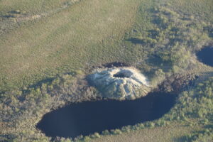
A warming Siberia, wracked by wildfires, nears a crucial threshold
Nearly 23 million acres burned from 1982 to 2020. But almost half of that occurred in 2019 and 2020, and the region may be near a threshold beyond which extreme fires become more common.
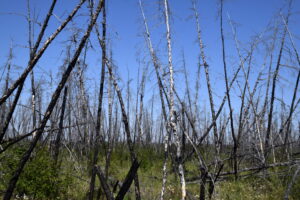
Rapid warming of the Arctic has led to the extreme wildfire seasons experienced in Siberia in recent years, scientists said Thursday, and such severe fires are likely to continue.
The researchers said that the Siberian Arctic, with its vast expanses of forest, tundra, peatlands and permafrost, was approaching a threshold beyond which even small temperature increases could result in sharp increases in the extent of fires.
Continue reading on The New York Times.

On October 27, Woodwell Climate Research Center scientists Dr. Jennifer Watts and Dr. Rich Birdsey presented their research on natural climate solutions to the congressional staff of the House Select Committee on the Climate Crisis. Established in 2019, the Select Committee is charged with developing innovative policies and strategies to address climate change.
Since January, Woodwell’s External Affairs Department and Carbon Program have been working to incorporate more effective provisions for natural climate solutions into the upcoming Farm Bill—U.S. federal omnibus legislation that includes a wide array of agricultural and forestry programs and is due for renewal in 2023. Woodwell has identified priority issues for the 2023 Farm Bill, and the External Affairs team has been conducting outreach to congressional offices in addition to Drs. Watts and Birdsey’s presentation to the Select Committee.
A specialist in quantitative methods for large-scale forest inventories, Dr. Birdsey has pioneered the estimation of national carbon budgets for forest lands. His portion of the presentation highlighted the declining carbon storage potential of U.S. forests due to factors such as deforestation and increasing natural disturbances, underscoring the need for more effective forest management to mitigate climate change.
“There are significant opportunities to reduce emissions from forest disturbances and increase carbon stocks on the land, but policies need to include safeguards to avoid unintended consequences, such as degrading unprotected lands that have disproportionately high carbon stocks and high biodiversity values,” Dr. Birdsey said.
Dr. Watts currently co-leads the Carbon Monitoring in Rangelands project, which is focused on creating the Rangeland Carbon Tracking and Management Tool (RCTM) to assess the true greenhouse gas consequences of rangeland management.
“Most U.S. agricultural lands are extremely vulnerable to climate change. We need a comprehensive risk assessment and mitigation plan in place to safeguard our nation’s food systems, while also restoring lands to protect and improve key ecosystem services such as carbon sequestration and biodiversity,” Dr. Watts said.
Her portion of the presentation detailed how climate change and land mismanagement are undermining the significant carbon storage potential of rangelands. The development of a widespread monitoring platform, like RCTM, would provide a robust process for monitoring, reporting, and verifying carbon credits and would inform more effective management practices.
Our nation’s policies must be informed by robust science to best harness the natural carbon storage potential of these ecosystems. Policymakers can help enable the successful implementation of natural climate solutions by incentivizing climate-smart land use, supporting the development of data-based carbon crediting systems, and investing in climate mitigation activities that leverage the potential carbon storage capacity of natural ecosystems.
According to Woodwell External Affairs Analyst Natalie Baillargeon, the 2023 Farm Bill represents a unique opportunity to implement some of these solutions, and reaching out to policymakers is an important step.
“The House Select Committee on the Climate Crisis effectively serves as a congressional think tank on climate solutions,” Baillargeon said. “It is incredibly important to make sure they have all the science and research necessary to develop strong policy approaches to addressing the climate crisis.”
Lula vowed to safeguard the Amazon. After Bolsonaro, it won’t be easy.
BRASILIA — When Luis Inácio Lula da Silva was elected president of Brazil on Sunday, Gustavo Conde felt a sense of relief — for himself and everyone.
“It feels like we can breathe again,” the 23-year-old cook said in downtown Brasilia. “And so will the planet.”
If Lula keeps his campaign promises to safeguard the Amazon rainforest, analysts say, Brazil could have a major impact on the worldwide fight against climate change, after years of accelerating deforestation under President Jair Bolsonaro. Scientists warn that the lungs of the planet, vital to slowing global warming, are approaching a tipping point.
Continue reading on The Washington Post.
Fingerprints of Change
We cruisers are acutely attuned to our surroundings, from weather and sea state to currents and marine life. We are also on the front lines of the impacts of a changing climate.

Over forty years ago, when my husband and I embarked on our five-year sailing adventure to circumnavigate the globe, the world was a different place. I was a different person.
During ocean passages back then, we often saw swarms of flying fish and vast pods of dolphins that sometimes stretched from one horizon to the other. Coral reefs we explored were vibrant and home to a mind-boggling diversity of sea creatures. It was easy to find a good-sized fish to spear for dinner, and trolled lines usually scored a catch, even for fisher know-nothings like us.
Arctic sea ice loss to increase strong El Niño events linked to extreme weather: Study

The 2015-16 El Niño fueled deadly record cyclones in the South Pacific and Mexico, as well as severe droughts that resulted in thousands of early deaths from fires and haze in southeast Asia and tens of millions going hungry amid crop failures in southern Africa.
Strong El Niños like that one could happen more frequently in the future as Arctic sea ice starts to disappear in the summer, according to a recent study published in Nature Communications. The research is the first to find a direct link between sea ice loss and the occurrence of El Niño, a warming of surface water in the eastern Pacific off of Peru that encourages higher global temperatures and extreme weather around the planet.
They keep us cool, we cut them down
Standing forests are our best natural climate solution. So why aren’t we treating them that way?
In terms of climate mitigation, forests are like green gold—working overtime to cool the planet, while also supporting a wealth of biodiversity. But we have not been saving them as one would a precious asset. Despite pledges to end deforestation, old growth forests are being cut down at alarming rates. And planting new trees is widely prioritized and incentivized over protecting existing forests. Across the board, standing forests are vastly undervalued. This has to change if we are to stand a chance of limiting warming to internationally agreed targets.
Forests are global air conditioners
According to a recent study from scientists at Woodwell and the University of Virginia, tropical forests alone are holding back approximately 1 degree Celsius of warming. About 75% of that cooling effect is due to carbon sequestration. Forests grow, trees lock away carbon in their trunks and roots and shunt it into the soil. The other 25% comes from the innate properties of forests that work to cool vast regions of the globe.
Through photosynthesis, plants release water vapor into the air in a process called evapotranspiration. The vapor contributes to cooling near the ground, as well as cloud formation higher in the atmosphere that reduces incoming solar radiation. The shape of the tree canopy also contributes. So-called canopy “roughness” disrupts air flow above the forest. The more uneven the canopy, the more turbulent the air, which disperses heat away from the surface. In the tropics, evapotranspiration and canopy roughness are high, which means that surface temperatures remain relatively low, with the heat dispersed throughout the deep atmosphere.
Forests also naturally produce molecules called biogenic volatile organic compounds (BVOC), which can either contribute to cooling by encouraging the formation of clouds, or to warming by creating ozone and methane. In the tropics, the net effect of these chemicals is cooling.
The cumulative result of these properties is that when forests are removed, the land around them begins to heat up even faster, which can increase the frequency of extreme heat and drought events. Without forests, some regions will become a lot less resilient to sudden shocks. And the release of carbon contributes to global warming which further exacerbates hot, dry conditions.
“Forests act like air conditioners,” says Woodwell Assistant Scientist, Dr. Ludmila Rattis, who studies the impacts of deforestation on agriculture in Brazil. “Deforesting in the face of climate change is like getting rid of your air conditioners before an upcoming heatwave.”
Not all forests are created equally
Protecting forests, and maintaining the cooling services they provide, is vital to limiting warming. But, with forests covering 30% of the Earth’s land, prioritizing protection is a massive task. And when it comes to carbon storage, not all forests are equally valuable. Older, healthier forests tend to have a more secure hold on their carbon.
“Mature forests have higher biodiversity and create their own microclimate,” says Woodwell Associate Scientist, Brendan Rogers. “They’re more resistant to drought and other types of disturbance. And because of that, they tend to be more stable in the face of environmental perturbations over time.”
New research from Woodwell and Griffith University has developed a method of identifying high-value forests using satellite imagery. Estimating the metric of “forest stability” through satellite data on the light reflected by vegetation and a water stress index of the tree canopy, researchers were able to determine gradients of stability within forest patches in the Amazon and boreal forests.
Using a gradient of forest stability allows for a better prioritization of forest protection strategies based on their carbon value.
“The first priority is to protect stable forests from further human disturbance,” says paper co-author Dr. Brendan Mackey. “The second priority is to identify forest areas where restoration efforts will be most cost effective.”
Guarding the forests that guard our future
But if the state of existing forests is any indication, forest protection continues to be deprioritized. Many wildfires are left to burn unless they threaten human settlements. Governments continue to incentivize deforestation for development or agricultural expansion. Indigenous and local communities are not compensated for their work stewarding their territories and keeping forests safe. And the warmer the planet gets, the more susceptible even protected forests become to drought, fire, and disease.
Research has shown that stewarding standing primary forests, and reviving degraded ones, represents the greatest opportunity for near-term carbon storage and removal. A study of global land-based carbon storage potential found that improved management of existing forests alone could store approximately 215 billion metric tons more than they currently do.
Protecting forests is cost effective, too. For example, in the United States, investing in fire fighting in Alaska’s boreal forests would require just $13 per ton of CO2 emissions avoided. That’s easily on par with other mitigation strategies like onshore wind or solar energy generation.
Effective strategies for protecting forests already exist, they’ve just been suffering from a lack of force—and often funding—behind their implementation. For example, forest carbon markets—where landowners and forest stewards are paid to protect standing forests that are otherwise vulnerable to deforestation—have the potential to keep forests safe while offsetting emissions from other sectors. But nascent carbon markets are inefficient, with weak standards for verifying the quality of credits being sold, and lacking the transparency needed to ensure credits are actually reducing overall emissions, rather than greenwashing carbon-intensive business practices.
Credits are also priced incorrectly for their relative climate value—the market currently values reforestation credits more highly, reducing incentive for landowners to conserve standing, old-growth forests when there is a better livelihood to be made in legally deforesting land for other uses. A truly effective carbon markets system would require large investments in science that can verify credit standards.
Forests are like our global carbon savings accounts—when we cut them down, we’re drawing out money and limiting our ability to collect interest and keep growing our funds. Successful mitigation can’t be accomplished without taking the full value of forests into account and strengthening policies to reflect that. If they aren’t, the planet will pay a far greater price for it as temperatures rise.
“We can’t afford to keep cutting forests. We need to reduce emissions now, and protecting forests is one of our best available solutions. Despite the obstacles, it’s worth the investment,” says Dr. Rogers.
