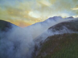
Summers in the Arctic-boreal region are becoming increasingly defined by fire. In 2023, Canada endured its worst wildfire season in history, with nearly 200,000 Canadians displaced. Fast forward to summer 2025, and the country faces its second-worst wildfire season on record, with 470 outbreaks deemed “out of control” by August. Siberia and Alaska are also confronting active fire seasons.
For Arctic communities, the physical impacts of smoke exposure, the toll of evacuations and destruction, and the threats to cultural traditions compound the danger of extreme fires. But Indigenous science and cultural traditions offer a path towards justice and resilience.
Climate change and colonial histories fuel the fire
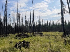
Climate change has created hotter and drier conditions in the north, increasing the frequency and intensity of Arctic-boreal wildfires. These wildfires amplify global warming, creating a feedback loop by burning deep into permafrost, a carbon-rich soil, and releasing stored carbon dioxide and methane into the atmosphere. A recent study led by Permafrost Pathways researchers found that wildfire has contributed to the Arctic’s shift from a net absorber to a net emitter of carbon. That increase in emissions in turn fuels even more fires. Between 2003 and 2023, the Arctic-boreal region saw a sevenfold increase in extreme wildfires.
“Things have really changed in our traditional territories,” said Woodwell Climate’s Adaptation Specialist, Brooke Woods. Woods is a Tribal member from Rampart, Alaska, and she currently lives in Fairbanks, Alaska. “We had two fires close to Rampart this summer. We’ve had back-to-back fires over the past three summers. Growing up, I don’t ever recall back-to-back wildfires surrounding our communities.”
The increase is also due, in part, to increased lightning strikes, which are occurring more frequently as warming temperatures further destabilize atmospheric conditions, leading to more storms that produce lightning.
“Our summers are drier and we’re having more severe heat events as well as more intense lightning and thunderstorms now, too,” said Woods. “When we had the fire in Rampart, in the midst of this wildfire, one of the storms actually produced 1600 lightning strikes across Alaska.”
The history of colonialism in North America has also played a role in today’s extreme wildfire regimes. For millennia, Indigenous Peoples across the Arctic practiced cultural burning—using small, controlled fires to manage the land, reduce dry fuel buildup, and prevent large, catastrophic wildfires. These practices not only protected ecosystems but also supported biodiversity and were deeply rooted in cultural knowledge and tradition. However, colonization disrupted these systems as Indigenous communities were forcibly removed from their lands, and cultural burning was often banned and criminalized altogether.
“Elders risked jail time for burning,” Dr. Amy Cardinal Christianson told Chatelaine Magazine. Christianson is a Metis wildfire expert and Policy Advisor for the Indigenous Leadership Initiative who co-hosts the podcast Good Fire and serves on the board of the International Association of Wildland Fire. “That’s how badly they knew that the land needed to burn.”
This erasure, combined with colonial fire suppression tactics, has led to the accumulation of flammable undergrowth that makes the land more vulnerable to intense and widespread fires.
Smoke, displacement, and cultural survival
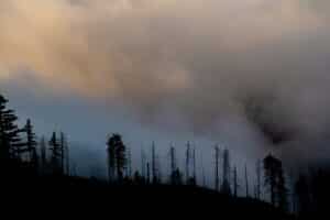
Increasingly active Arctic-boreal wildfires are not just environmental disasters, they’re also cultural and human crises.
Wildfire smoke—which can contain soot and high levels of mercury— threatens the health of Arctic communities and can put vulnerable groups, like elders, young children, and those with pre-existing health conditions, at prolonged risk well after the fires have gone out.
“In my baby’s first year of life in 2023, we had such bad air quality [in Fairbanks]. It impacted his respiratory system, and it was just so hard for him to be able to nurse,” said Woods. “I was even considering driving 300 miles to the next urban area to get him to clean, healthy air because there was also a fire in Rampart. It impacted our safety in both of the places that we call home.”
The mental toll of wildfires can also be just as devastating as the physical impacts, as communities must navigate evacuation logistics, loss, and displacement with very little governmental support.
“Communities are thinking about how the wildfire crisis is real—it’s driven them from their home and maybe destroyed their home—they’re thinking ‘what else am I going to lose’?” said Edward Alexander, Senior Arctic Lead at the Woodwell Climate Research Center, Chair of Gwich’in Council International, and Co-Chair of the Arctic Council’s Expert Group on Wildland Fire. “Then, becoming unhoused… people lose their jobs, their businesses, or their investments. They lose forward momentum in their life.”
In addition, evacuation is far more complicated in the Arctic. Many remote communities and villages in Alaska and Canada either have only one main road or aren’t connected to road systems at all, making them accessible only by plane or boat, which presents a logistical and financial challenge for mass evacuation. The combined impacts of smoke, heat, and economic insecurity can also present impossible choices.
“If you look at not only the health disparities but your income, what can you afford to keep yourself healthy?” said Woods. “Can you afford air filters for your home? Can you afford and have access to air conditioners with filters? Because not only are you battling the smoke, but you’re also battling this heat. So just navigating those at different income levels can be very complex.”
Fire doesn’t just destroy infrastructure and threaten health and well-being, it also disrupts Indigenous ways of life, cultural connections to land, intergenerational knowledge sharing, language revitalization, and cultural history tied to specific places like hunting trails, fish camps, and seasonal migration.
“When we were still able to subsistence fish in Alaska, and had wildfires at the same time, there were community members in Rampart that were not able to meet all of their subsistence needs due to wildfires,” Woods said.
Traditional solutions for modern problems: A return to cultural burning
In Good Fire, Christianson discusses ways to restore the modern world’s broken relationship with fire and the need to integrate systems that not only respond appropriately but are also proactive and predicated on Indigenous Knowledge and expertise. This is where cultural burning offers a way forward—a way to view fire not as a threat, but as a critical tool for keeping land healthy and communities safe.
The First Nations Emergency Services Society (FNESS) and the Indigenous Leadership Initiative (ILI) recently released the “Create a Cultural Burn Pathway” workbook to support Indigenous communities in creating cultural burn programs to reduce wildfire risk and maintain healthy connections to the land.
“Fire doesn’t have to be scary,” said Christianson in a video produced by the Indigenous Leadership Initiative. “It doesn’t have to be something we live in fear of every summer. We can have a better relationship with fire that can have really important benefits.”
Traditional burning is a culturally grounded, community-empowered, and ecologically practical approach to managing and mitigating wildfire risk in the North, born from generations of Traditional Ecological Knowledge. Unlike conventional fire suppression, which often seeks to eliminate fire altogether, cultural burning is a proactive, place-based practice rooted in Indigenous governance, values, and ecological understanding. These approaches aren’t about fighting fire—they’re about embracing it to foster sovereignty, revitalize knowledge, and deepen connection to the land.
Beyond the health of the land and forests, cultural fire also contributes to cultural resilience and maintains Indigenous connections to land and community. Cultural burns ensure practices are guided by traditional protocols and adapted to local ecosystems. Community members, including youth, are involved—passing knowledge between generations and restoring cultural roles that were disrupted by colonization.
Which is why, according to Alexander, placing the emphasis on the health of the forest, ecosystems, and community overall, rather than on controlling fire, should be the real goal.
“We should be thinking a little differently,” Alexander said. “Cultural fire is a tool, but fire is not the emphasis. It’s the health of the forest, it’s the health of the land, it’s the health of the animals and birds, it’s the health of our peoples and communities. That’s the emphasis.”
From ‘wildfire to mildfire,’ Indigenous fire stewardship as a path forward
Cultural burning is just one part of the solution, which will involve moving away from colonial fire suppression methods altogether and supporting Indigenous-led fire stewardship models with meaningful changes in policy and funding. Woods says she’d like to see Indigenous-led fire programs represented as part of a broader recognition of Indigenous sovereignty in the North.
“I’d like to see more local people leading the work rather than just renting out their equipment or hiring them as boat captains,” Woods said. There are more opportunities for Indigenous People to help their own communities. I feel there’s always time to course correct and really acknowledge and honor the 229 Tribes of Alaska and their practices that have maintained very healthy land and ecosystems for so long.”
In Alaska, Indigenous-led wildfire initiatives—like the U.S. Bureau of Land Management (BLM) Emergency Firefighter (EFF) program—create opportunities for local members of Alaska Native communities to join crews and integrate their traditional knowledge and expertise of the land to help keep their communities safe. In Canada, Fire Guardian programs—which Dr. Christianson has long been advocating for—aim to get good fire back on the land through Indigenous stewardship and traditional practices.
Alexander says he hopes recognizing cultural burning and other forms of Indigenous Knowledge as legitimate science will help prioritize them in land management.
“It’s critically important science that we need to help us manage the wildland fire crisis in the circumpolar north,” said Alexander.
Alexander imagines a future where wildfire becomes mildfire. Where communities in the north are adequately resourced and wildfire management becomes proactive and rooted in Indigenous Knowledge and expertise, while prioritizing and supporting sovereignty.
“Indigenous fire management looks like a vibrant landscape where you don’t have severe wildland fire, but you have increased biodiversity, where the vegetation is more nutritious for the plants and animals, and that permafrost and other hugely important resources are protected,” Alexander said. “I also think that it’s an integral part of respecting the sovereignty of Indigenous Peoples, of respecting the self-determination of Indigenous Peoples to manage our territories how we see fit, and I think that it’s a really critical approach that we need to all be listening to. Our collective future really depends on it.”
An unusual sight over Canada’s Arctic: Wildfire smoke
Once rare, wildfire smoke is becoming more prevalent in Arctic communities as Canada faces harsh wildfire seasons.
Elizabeth Mikkungwak thought the nearby garbage dump must be on fire. Acrid smoke clouded the skies over Baker Lake, a tiny Arctic hamlet and the only inland community in Nunavut, the largest in area of the three northern territories in Canada.
A safety alert issued by the authorities in the hamlet in May gave the real reason for the smoke: wildfires on the Prairies.
Read more on The New York Times.
Meeting the moment: Fund for Climate Solutions awards five new grants
From Mongolia to the Cerrado, FCS projects are tackling climate’s most pressing research questions
By Maggie Lin
The second round of 2025 Fund for Climate Solutions (FCS) awardees has been announced. The FCS advances innovative, solutions-oriented climate science through a competitive, internal, and cross-disciplinary funding process. Generous donor support has enabled us to raise more than $10 million towards the FCS, funding 79 research grants since 2018. In a volatile environment for climate research and policy, this summer’s five collaborative project teams are bringing their ambition and creativity to solutions that meet time-sensitive needs.
Additional funding will help to expand the Fund for Climate Solutions. If you are interested in learning more, contact Leslie Kolterman at lkolterman@woodwellclimate.org or (508) 444-1584.
Tracking forest structure and emissions from logging mature and old-growth forests on federal lands
Leads: Dr. Richard Birdsey, Dr. Wayne Walker, Seth Gorelik
The federal administration has ordered the Forest Service and Bureau of Land Management to increase logging of federal forests by 25% over the next few years, with detailed project-level planning expected before the end of 2025. There are few, if any, guardrails that protect the most valuable young, mature, and old-growth forests. With collaborators from Conservation Biology Institute, World Resources Institute, and Natural Resources Defense Council, this project will track carbon stock reductions from greatly scaled up logging, especially where it targets older forests. The team will also model the impacts of a 25% increase in logging across all federal lands. Their methods build upon extensive prior research, and will integrate data from satellite observations, forest inventories, and published activity reports to provide analysis that can support public engagement and policy analysis.
Mongolia grazing lands initiative: Knowledge co-production and mapping with Dukha reindeer herders in Mongolia
Leads: Greg Fiske, Christina Shintani, Jackie Dean
The Dukha people of Mongolia, like other Indigenous peoples, have lived respectfully and in harmony with the land since time immemorial. Now, their lifeways are being challenged by climate change and land use decisions made without proper consultation and consent. On the Mongolian Plateau, the rate of summertime warming is three times faster than the average for Northern Hemisphere lands, causing permafrost thaw and changes in vegetation. The project team will map land use changes impacting Indigenous grazing lands in Mongolia and train Indigenous reindeer herders in GIS map storytelling tools. Grounded in co-production of knowledge, this work will build on past successes working with Sámi reindeer herders in Norway and Indigenous communities in Alaska. It will also expand Woodwell’s rangeland work into East Asia, leveraging existing partnerships with Esri and the International Centre for Reindeer Husbandry.
A novel framework for defining and quantifying degradation in fire-prone tropical forests
Lead: Dr. Manoela Machado
Collaborators: Dr. Andréa Castanho, Dr. Marcia Macedo, Dr. Wayne Walker
Brazil’s vast tropical savanna, the Cerrado, is both a global biodiversity hotspot and a provider of vital ecosystem services. It is experiencing the highest deforestation rates among Brazilian biomes, driven primarily by the expansion of mechanized agriculture—nearly half of the Cerrado’s original vegetation is already lost. The region has weaker legal protections than the Amazon, resulting in land conversion being displaced into the Cerrado. Part of the challenge is that defining and measuring degradation in the Cerrado can’t be reduced to the loss of biomass alone: the biome is dependent on disturbances like fire that temporarily reduce biomass, but are also essential for sustaining ecological integrity. This project responds to increasingly urgent calls from government agencies, environmental nonprofits, and carbon market participants to develop an operational framework of Cerrado degradation that accounts for the ecosystem’s natural variability. This project will build Cerrado-specific definitions of degradation and deliver both a monitoring framework and a map assessing 2024 degradation. The team, including collaborators from IPAM and the University of Oxford, plans to build on these outcomes to seek funding for expanding this framework to other disturbance-dependent ecosystems, including savannas around the world.
Responsible solar geoengineering research and governance: Scoping a role for the Woodwell Climate Research Center
Lead: Dr. Peter Frumhoff
Collaborators: Dr. Jennifer Watts, Jamie Cummings, Dr. Brendan Rogers, Dr. Christopher Schwalm, David McGlinchey
Researchers and policymakers are increasingly assessing the effectiveness and risks of solar geoengineering—interventions intended to rapidly cool the Earth by reflecting a portion of incoming sunlight back into space. Woodwell Climate previously established an organizational position that “responsible research is needed to inform decision-making regarding whether and how solar geoengineering should ever be considered for deployment.” This project will investigate whether Woodwell should further responsibly-goverened solar geoengineering research, building on our strong position statement, our distinctive expertise in Arctic warming and federal policy engagement, and our relationships with Arctic Indigenous communities. The team will invite expert speakers for presentations to Woodwell staff; hold a series of scoping interviews with leading researchers, NGOs, Arctic community thought-leaders, and philanthropists; and co-convene an international workshop with the Harvard Kennedy School’s Arctic Initiative.
Understanding how wildfire impacts permafrost thaw depths
Leads: Dr. Anna Talucci, Dr. Brendan Rogers
Collaborators: Dr. Elchin Jafarov, Dr. Kayla Mathes, Dr. Christina Schädel
When high-latitude northern landscapes experience wildfire, plants and organic matter in the soil are burned away, leading to increased soil temperatures and permafrost thaw. Dr. Anna Talucci previously led a publication that synthesized existing research to drastically increase the amount of data that is available to modelers on the depth of actively thawing and re-freezing ground in burned and unburned research sites across the northern tundra and boreal regions. This project will build on that data to investigate what drives active layer recovery and fill key gaps to support permafrost modeling by Woodwell researchers. The team aims to publish their findings in a scientific journal and submit an abstract to present to colleagues at the next American Geophysical Union annual meeting. They will also develop a funding proposal to seek support in investigating the questions their research reveals about more complex permafrost-wildfire interactions.
Trees play a crucial role in mitigating the effects of climate change by absorbing climate-warming carbon dioxide from the atmosphere. As temperatures climb and human activities release more and more carbon, managing and protecting trees has become essential to curbing global warming.
In 2021, partners at Woodwell Climate Research Center, Local Governments for Sustainability (ICLEI), and the World Resources Institute (WRI) launched a tool providing communities with fine-scale information about their trees to better manage and protect them.
The Land Emissions and Removals Navigator (LEARN) tool is an interactive map and data analysis system that contains remote sensing and forest inventory data on tree cover, land use change, disturbances, and carbon stocks. Users – mostly county and municipal planners – can generate a custom estimate of carbon emissions and removals from trees for any area in the contiguous United States.
“That’s the idea with the LEARN tool – it makes these complicated datasets readily accessible,” Dr. Rich Birdsey, Senior Scientist at Woodwell Climate and collaborator on LEARN, says.
Easily accessible tree cover data gives community members the opportunity to take action at the local level. For example, a city planner might use LEARN to see if trees are gaining or losing cover in their city. If trees are losing cover, they can work with their municipal departments to increase the urban canopy.
In the last year, scientists added the ability to identify mature and old-growth (MOG) forests to the tool. MOG forests are the later stages of forest development, where trees are larger and store more carbon than younger forests. They are also more resilient and adaptive in the face of disturbances and play a role in maintaining biodiversity by providing habitat for wildlife. This makes them a high priority for protection.
In addition, users can now view the protection status of an area. Ranging from low to high, they describe what activities – like logging and mining – are allowed in the area. Users can draw connections between activities and carbon estimates, and hopefully, change local land management practices to better protect their trees.
LEARN’s protection statuses include:
- Low Protection: These areas lack full protection from land conversion, with some allowing extractive uses like logging or mining while protecting endangered species, and others having no mandates preventing habitat conversion, often involving private or developed lands.
- Medium Protection: This category includes USFS Inventoried Roadless Areas, which currently have protection from land conversion, but allow for moderate uses or management practices, not including commercial timber harvest, that may impact natural communities.
- High Protection: These areas have permanent protection from land conversion or active management, maintaining a natural state with only a few exceptions such as addressing safety concerns.
“The assessment is more relevant now because the Department of Agriculture has proposed a rule that would relax forest protections, particularly with respect to roadless areas,” Birdsey says.
In June, U.S. Secretary of Agriculture Brook Rollins announced that the U.S. Department of Agriculture is rescinding the 2001 Roadless Rule. The rule protected 58 million acres of roadless land within the National Forest System from construction and commercial logging. With no protections for roadless areas, logging and commercial uses of land will be allowed.
“Because of the large area currently designated as roadless, and the significant area of mature and old-growth forests within these areas, this is of great concern to the conservation community,” Birdsey says.
Birdsey hopes that the LEARN tool can mobilize community members and land managers to take action. Whether it be working with local governments to protect MOG forests or connecting neighboring counties to each other, communities can collaborate to tackle climate change on a local level.
“Since federal policies are opening up more public land to logging, it is becoming more important than ever for local communities to weigh in on forest management plans,”Birdsey says.
IPCC concludes selection of authors for its Seventh Assessment Report

The Intergovernmental Panel on Climate Change (IPCC) has appointed 664 experts from 111 countries to participate in the Seventh Assessment Report (AR7) as Coordinating Lead Authors, Lead Authors and Review Editors.
These experts were nominated by governments and IPCC observer organisations and selected by the IPCC Bureau from a global pool of 3,771 nominees.
Read more on the IPCC website.
The EPA’s 2009 Endangerment Finding has underpinned almost all U.S. efforts to reduce greenhouse gas emissions, making it a prime target for the Trump administration’s rollback of climate policies. A day-one executive order included a directive to review the “legality and continuing applicability” of the finding. On March 12, the EPA announced that it would potentially rescind the Finding, and the announcement was formalized with a proposed rule on July 29.
Repealing the Finding would undo more than a decade of work that has made American communities healthier, skies clearer of smog and other pollution, and contributed to the country’s decreasing carbon emissions.
What is the Endangerment Finding?
The Endangerment Finding is a pivotal determination by the EPA, issued in response to the 2007 U.S. Supreme Court Case Massachusetts vs. EPA. In that case, the court held that the EPA has the authority to regulate greenhouse gases under the Clean Air Act, and that after it has made a finding of endangerment, the agency cannot refuse to regulate these gases.
Additionally, the EPA found that greenhouse gases in the atmosphere are both a hazard to public health and that motor vehicle emissions contribute to this pollution. In the years since, the EPA has built on the original ruling and issued subsequent endangerment findings relating to aircraft and utility emissions under other provisions of the Clean Air Act .
Why is the Endangerment Finding important?
As a result, the Endangerment Finding has become the legal foundation for essentially all federal regulation of greenhouse gas emissions in the U.S. – including motor vehicle tailpipe emissions and power plant rules.
The EPA’s proposed rule would repeal all greenhouse gas emissions standards for light-duty, medium-duty, and heavy-duty vehicles and engines, and would preempt any state fuel efficiency or vehicle emissions laws or regulations. Furthermore, this repeal could be a foundation for undoing greenhouse gas emissions regulations on stationary sources like power plants or oil and gas facilities.
The Endangerment Finding is based on sound science
The attempt to repeal the Endangerment Finding is emblematic of the current administration’s disregard for scientific consensus around the causes and impacts of climate change.
The original finding draws from expertise at the U.S. Global Change Research Program, the Intergovernmental Panel on Climate Change (IPCC), and the National Academies of Sciences. It examined public health and public welfare in the U.S., with a focus on air quality, food production and agriculture, forestry, water resources, sea level rise and coastal areas, energy, infrastructure, and settlements, and ecosystems and wildlife. The EPA received over 380,000 public comments, the majority of which provided support for the Finding.
In 2018, Dr. Philip Duffy, then-president of Woodwell Climate Research Center, led a review of the scientific foundation of the Endangerment Finding. That work, published in the journal Science, found that “for each of the areas addressed in the EF, the amount, diversity, and sophistication of the evidence has increased markedly, clearly strengthening the case for endangerment. New evidence about the extent, severity, and interconnectedness of impacts detected to date and projected for the future reinforces the case that climate change endangers the health and welfare of current and future generations.”
What’s next for climate policy?
The legal validity of the administration’s proposed rule was contested almost immediately and challenges will likely continue to roll in even if the rule is made official.
The EPA has extended a public comment period on this topic through September 22, 2025. The recently released Department of Energy (DOE) report, A Critical Review of Impacts of Greenhouse Gas Emissions on the U.S. Climate, which challenges scientific consensus by claiming that carbon dioxide-induced warming appears to be less damaging economically than commonly believed, serves as a foundation for the EPA’s proposed rule. That report is also open for public comment through September 2, 2025.
The National Academy of Sciences has fast-tracked its scientific review of the impacts of greenhouse gases on human health in order to inform the decision within the comment period, and has requested contributions from scientists and experts in the fields of public health, extreme weather, climate modeling, agriculture, and infrastructure. Woodwell Climate is contributing to the opportunities for public comment and scientific engagement to aid future consideration of this, and similar, proposals in courts and encourages members of the public to do the same.
As Canada wildfires choke US with smoke, Republicans demand action. But not on climate change
The sternly worded statements and letters are filled with indignation and outrage: Republican U.S. lawmakers say Canada has done too little to contain wildfires and smoke that have fouled the air in several states this summer.
“Instead of enjoying family vacations at Michigan’s beautiful lakes and campgrounds, for the third summer in a row, Michiganders are forced to breathe hazardous air as a result of Canada’s failure to prevent and control wildfires,” read a statement last week from the state’s GOP congressional delegation, echoing similar missives from Republicans in Iowa, New York, North Dakota, Minnesota and Wisconsin.
They’ve demanded more forest thinning, prescribed burns and other measures to prevent fires from starting. They’ve warned the smoke is hurting relations between the countries and suggested the U.S. could make it an issue in tariff talks.
Experts emphasize need for Interior Alaska wildfire mitigation
Earlier this summer, Interior Alaska wildfires were so widespread, Fairbanks resident Nettie La Belle-Hamer had to prepare a go-box in case the flames encroached too closely on her home.
La Belle-Hamer, deputy director of the University of Alaska Fairbanks Geophysical Institute, brought that firsthand experience along with plenty of scientific knowledge to this year’s Arctic Encounter Symposium, an annual conference focused on the region.
La Belle-Hamer was joined by four other panelists — three of whom live in the Interior — to discuss methods to address wildfires in the Arctic, as well as strategies to implement fire mitigation in the Arctic to protect permafrost melt.
Continue reading on Anchorage Daily News.
