In the Amazon Rainforest, there is no such thing as a natural fire. Yet every year we see headlines of rainforest vegetation aflame, smoke drifting across populated areas, and stored carbon spilling into the atmosphere. So how does a rainforest—one of the wettest ecosystems on Earth—catch fire?
Climate impacts on Amazon fire
Whether directly or indirectly, human activities are the root cause of fire in the Amazon.
In order for a fire to start anywhere, you need three things— favorable climatic conditions, a fuel source, and an ignition source. In the Amazon, each side of this “triangle of fire” has been exacerbated by warming temperatures and deforestation, creating flammable conditions that can allow fires to spread out of control deep into the forest once they are ignited.
Climate conditions
High temperature and dryness combine to create the right conditions for fires to spread through the Amazon. As global temperatures have risen, the Amazon region has become hotter and drier, more vulnerable to prolonged droughts and extreme climatic events. Most recently, a climate-driven drought spanning 2023 and 2024 has deeply impacted water levels in the forest— to the point of isolating riverside communities.
Wildfire danger days, or days considered hot and dry enough to increase the likelihood of fire, have become a much more common occurrence deeper in the Amazon, where previously it was just too wet to burn.
Fuel
Felled trees and dry vegetation form the fuel for more fires in the Amazon. How do the trees fall? Some are killed in extreme drought and previous fire, but many are intentionally cut, pushed over by bulldozers for conversion of forest to pasture land. Large-scale deforestation has been advancing into the Amazon for decades, fragmenting thick blocks of forest and replacing them with ranch or farm land. Scientists and activists have been pushing for an urgent stop in deforestation to achieve, among other benefits, a drop in fire numbers. However, despite slowly declining deforestation rates, fires are still increasing, pointing to another important piece of the puzzle – degradation.
When a forest is fragmented by deforestation, it degrades the vegetation that remains standing. Forests along the edges of clearings dry out and weaken, making them more susceptible to future burning. And burning weakens nearby forests yet again, creating more available fuel, setting off a chain of degradation.
Ignition
Ignition in the Amazon is almost entirely human caused— whether accidentally or intentionally. Ranch and farm operations both legally and illegally clearing Amazon rainforest use fire to burn away cut vegetation or prepare existing pasture land for other uses. With climate change creating hotter and drier conditions, and lengthening the dangerous dry season, any ignition becomes potentially risky, whether or not its use is legalized. Especially where forest edges have already been weakened.
However, a study led by Woodwell Climate Postdoctoral Researcher and fire ecologist Dr. Manoela Machado, found that long-term solutions to the Amazon’s fire crisis will require distinguishing between the complex uses of fire. One-size-fits-all fire bans, usually employed as emergency measures and not always strictly enforced, may reduce fire in the short term, but don’t adequately address the underlying reasons people have decided to burn the land.
Ending deforestation and supporting firefighters
Fire in the Amazon follows deforestation and degradation, namely from logging, fires, droughts and fragmentation. Climate change and human encroachment have worked in concert to foster a devastating annual burning regime in the Amazon rainforest that threatens one of the Earth’s most valuable mechanisms for keeping the planet cool.
Eliminating fire from the Amazon will require the elimination of deforestation and degradation sources, as well as the enforcement of strategic fire bans and support of firefighting brigades. Machado, has led several successful workshops with Indigenous fire brigades in Brazil, bringing together groups from across the country to learn about Geographic Information Systems (GIS) technology they can use to monitor and manage their own forests.
According to Machado, a big part of fire prevention happens in the off-season. Support for activities like community outreach, building fire breaks in collaboration with farmers, and technical assistance to replace legal use of fire, can all help reduce the prevalence of catastrophic fires when the dry-season comes around.
The Amazon is a massive place, and firefighting can be a dangerous job. Especially on the frontiers of deforestation, where land grabbing and illegal deforestation are common and fire fighters are often threatened to stay out of an area. Ultimately, government support, bolstered enforcement of deforestation laws, and viable alternative livelihoods have a major role to play in bringing down fires, alongside continued global efforts to curb climate change.
A new study, just published in the journal Nature Communications Earth & Environment, finds that severe droughts in the Amazon basin over the last two decades have led to longer periods of low water levels and triggered profound impacts on the local population.
The severe droughts in 2005, 2010, and 2015-2016, in particular, not only drastically reduced water levels in a substantial part of the world’s largest river system, but also resulted in low water level periods exceeding 100 days, a month longer than expected.
These droughts have major impacts on rural, remote Amazonian communities who heavily rely on inland water transport to access goods and services, reach urban centers, and maintain their livelihoods. The study concludes that during severe droughts, when such water transport is not available, nearly 50% of non-Indigenous localities and 54% of Indigenous villages in the Brazilian part of the Amazon basin are prone to isolation. These droughts also expose Amazonian communities to scarcity of goods, restricted access to healthcare and education, limited access to fishing and hunting sites, and other major impacts.
“This is the new reality of the Amazon,” said Dr. Letícia Santos de Lima, researcher at the Institute of Environmental Science and Technology of the Universitat Autònoma de Barcelona (ICTA-UAB) and lead author of the study. “Scientists have been warning for years that the Amazon basin is facing a substantial increase in the frequency and intensity of extreme events due to climate change, on top of severe changes in its hydrological system due to deforestation and forest degradation. These past droughts as well as the most recent one, 2023-2024, are showing that the impacts on the ecosystems extend severely to the Amazon population.”
“The Amazon faces increasingly severe droughts due to global warming, with very real consequences for the communities that live there,” added Dr. Marcia Macedo, Woodwell Climate Research Center scientist and study co-author. “To better prepare for these extreme climate events, we need climate solutions that prioritize water resources alongside efforts to curb carbon emissions. This will be key for sustaining resilient ecosystems and communities in the Amazon and around the world.”
The paper states that “actions to cope with recent droughts in the Amazon have been reactive rather than proactive and grounded in preparedness and adaptation principles,” and calls for Amazon countries to “develop long-term strategies for mitigation, adaptation, and disaster response.” The authors also stress that any solutions to isolation must not also worsen the problem. For example, roads would not be an effective solution as they are a well-known driver of deforestation, which leads to changes in rainfall, contributes to a higher volume of sediments in rivers, and would impair navigability even further.
Using an interdisciplinary approach, researchers combined spatial analysis, methods from hydrology, and news media content analysis to deliver the first spatiotemporal assessment of cross-sectoral impacts of droughts in the Amazon basin.
O céu se abre no momento em que nosso caminhão deixa o último trecho de estrada pavimentada. A Diretora do Programa de Água, Dra. Marcia Macedo, aperta os olhos para manter o foco no que consegue ver entre uma limpeza e outra do para-brisa. Em poucos minutos, nosso caminho se transformou de uma estrada de terra em um leito de rio de lama laranja brilhante, sulcado pela passagem de caminhões pesados que transportam soja das fazendas vizinhas.
Macedo desvia para evitar solavancos e depressões, mas logo há mais deles do que estrada plana. Nós nos preparamos para as poças, olhando pelas janelas salpicadas de spray laranja.
É uma manhã de segunda-feira, na estação chuvosa, nos arredores da Amazônia, e estamos indo para o trabalho.
A Estação de Campo de Tanguro fica a cerca de uma hora de carro de Canarana, a cidade mais próxima, localizada em uma região do Brasil às vezes chamada de arco do desmatamento. Há várias décadas, a agricultura começou a surgir na região sul da floresta amazônica, criando áreas retangulares de terras agrícolas na floresta primária. Na maior parte do trajeto, somos ladeados apenas por megacampos de soja ou pastos de gado.
Macedo, que realiza pesquisas na Tanguro desde 2007, lembra-se de uma época em que a viagem poderia ter sido marcada pela travessia do limiar das savanas florestais do Cerrado – Brasil – para a Amazônia. Agora, o desmatamento próximo à estrada obscureceu essa transição natural. Eventualmente, no entanto, tufos verdes exuberantes emergem da chuva e percebemos que estamos quase lá.
Desde a sua fundação em 2004, a Tanguro tem oferecido a pesquisadores de todo o mundo a oportunidade de investigar grandes questões sobre como as mudanças climáticas e o desmatamento estão afetando a Amazônia. Macedo e sua equipe vieram para estudar os córregos e reservatórios da Tanguro.
Paramos do lado de fora da estação de pesquisa, tirando as malas, embrulhadas em sacos plásticos de lixo, da caçamba da caminhonete. A assistente de pesquisa, Zoe Dietrich, segura vários componentes eletrônicos vitais no peito, levando-os para uma varanda coberta para protegê-los da chuva. A pós-doutoranda Dra. Aibra Atwood começa a retirar tubos de núcleo de sedimentos de uma pilha de equipamentos. As nuvens se dissipam e o dia de trabalho na Tanguro começa.
A Fundação
A decisão de se estabelecer na fazenda Tanguro causou polêmica na época.“Quase nos separou”, lembra o fundador da Tanguro, Dr. Daniel Nepstad. “Tivemos uma discussão que durou dois dias.”
Quatorze anos antes, Nepstad havia estabelecido o programa amazônico no Woodwell Climate (então Woods Hole Research Center) no estado do Pará, estudando a resiliência das florestas amazônicas durante as longas estações secas. Esse trabalho deu origem a um novo instituto de pesquisa com sede no Brasil – em 1995, Nepstad cofundou o Instituto de Pesquisa Ambiental da Amazônia (IPAM) em Belém para buscar ciência relevante para políticas que pudessem informar o desenvolvimento sustentável na Amazônia. A Woodwell Climate e o IPAM começaram a realizar experimentos de simulação de secas e descobriram que a floresta tropical, que há muito tempo era considerada imune ao fogo, perdia essa resistência durante secas severas. Para investigar as implicações disso, Nepstad percebeu que eles precisavam de um novo experimento em algum lugar na borda da Amazônia, onde é mais seco o ano todo.
Nepstad vinha passando cada vez mais tempo no estado do Mato Grosso, interessado pela expansão do cultivo de soja na Amazônia. Durante sua busca por um novo local de estudo, o Grupo Amaggi fez um convite extraordinário.
O Grupo Amaggi era, na época, o maior produtor de soja do mundo, e a soja estava rapidamente se tornando o inimigo ambiental número um, à medida que centenas de milhares de acres de florestas eram derrubados para expandir seu cultivo.
“Mas o Grupo Amaggi, uma empresa brasileira, queria se antecipar à questão”, diz Nepstad. A perspectiva de perder um mercado importante na Europa levantou questões sobre o melhor caminho a seguir. Em 2002, eles criaram o primeiro sistema para rastrear as práticas florestais dos agricultores que lhes vendiam soja. Em 2004, eles fizeram um convite a Nepstad para pesquisar as florestas em sua recém-adquirida propriedade Tanguro, um conjunto de fazendas de gado desmatadas que estavam em processo de conversão para campos de soja.
A esperança era que a pesquisa demonstrasse ao mundo o que realmente estava acontecendo nessas enormes fazendas de soja na Amazônia, fornecendo dados que poderiam contribuir para conversas sobre soja sustentável.
“Há vinte anos, havia muitas discussões sobre preservação ambiental e agricultura”, diz a Diretora de ESG, Comunicações e Conformidade do Grupo Amaggi, Juliana de Lavor Lopes. “Esses dois podem criar uma simbiose? Acho que sabíamos que [eles] poderiam trabalhar juntos, mas será que poderíamos provar isso?”
Para Nepstad, o convite também foi a oportunidade perfeita para realizar um experimento de fogo controlado em um local ideal. Após muitos debates, o IPAM decidiu aceitar.
“Muitas pessoas temiam que isso arruinasse nossa reputação, minasse nossa credibilidade junto às organizações de base – muitas ONGs achavam que estávamos nos vendendo”, diz Nepstad. “Algumas pessoas nos acusaram de termos sido comprados pelo Grupo Amaggi.”
Mas Nepstad foi muito claro quanto aos termos da parceria. Eles não aceitariam nenhum dinheiro da empresa além do que o Grupo Amaggi investiu nos prédios do campus da estação de pesquisa. E eles só apoiariam as atividades da fazenda na medida em que a ciência permitisse. A pesquisa relataria com precisão os impactos da agricultura sobre a floresta, sem restrições de publicação
Assim, em 2004, com poucos recursos financeiros, mas acompanhados por uma equipe dedicada de técnicos de campo e pesquisadores dos experimentos de seca no Pará, – alguns dos quais ainda trabalham na estação de campo atualmente – Woodwell e IPAM montaram um acampamento na Tanguro.
A vida na estação
As botas sujas de lama começam a fazer fila do lado de fora da porta do refeitório às 11h50. Donna Lucia serve o almoço pontualmente ao meio-dia.
Maria Lúcia Pinheiro Nascimento administra a cozinha da Tanguro há mais de 16 anos, preparando refeições fartas para cientistas e técnicos de campo famintos três vezes ao dia. O almoço e o jantar geralmente envolvem alguma carne grelhada ou cozida lentamente, arroz, feijão e uma salada fresca ou legumes assados. Hoje tem abóbora, abobrinha e sobras de linguiça e peito do churrasco de ontem à noite. O café da manhã é mais leve – pão de queijo, ovos, pão fresco, frutas e café – preparado e devorado antes do início do trabalho às 7h.
Muitos dos técnicos que vivem e trabalham aqui cinco dias por semana dizem que a Tanguro é como uma segunda casa, e seus colegas, uma segunda família. Para Dona Lúcia, como é chamada pelos funcionários e visitantes, cozinhar para a estação de pesquisa não é como cozinhar para a família. É realmente cozinhar para a família. Seu marido, Sebastião Nascimento, o “Seu Bate”, foi um dos primeiros técnicos de campo a trabalhar no experimento de seca no Pará. Ele voou para se juntar à equipe da Tanguro um ano após a fundação da empresa e trouxe sua família um ano depois, incluindo seu filho, Ebis Pinheiro de Nascimento, que também entrou como técnico de campo. Um terceiro técnico do Pará, Raimundo Mota Quintino, conhecido como “Santarém”, juntou-se à família quando se casou com a filha de Dona Lúcia.
“Estou com minha família”, diz ela. “Isso me traz alegria.”
Com ou sem parentesco, a equipe da Tanguro trabalha em conjunto, como uma família. A cooperação e o respeito são essenciais em um lugar tão remoto e desconectado (o wifi só se estende a cerca de 18 metros do prédio da cantina) como a Tanguro.
“Brincamos que é como se fosse o ‘Big Brother’”, diz o gerente de campo Darlisson Nunes da Costa. “Mas estamos realmente unidos e nos respeitamos mutuamente. É um ambiente maravilhoso para se trabalhar”.
Também pode ser um ambiente fisicamente desafiador, com longos dias de calor e umidade, preocupações com a segurança em uma floresta cheia de cobras e onças, porcos selvagens territoriais e terrenos que podem facilmente causar uma torção no tornozelo. Ao mesmo tempo, garantindo que os cientistas obtenham os dados de que precisam.
Todo técnico de campo precisa ser adaptável e versátil, pois, além dos horários das refeições, não há rotina diária. Sua manhã pode envolver o corte de videiras para encontrar um caminho para um riacho escondido, selecionado a partir de imagens de satélite como um local de amostragem. A tarde pode ser dedicada à solução de problemas em uma das torres de monitoramento de carbono.
“Não podemos dizer que temos um trabalho monótono”, diz Seu Bate. “Fazemos de tudo um pouco.”
Mesmo assim, cada um dos técnicos desenvolveu suas especialidades ao longo das décadas. Santarém ainda usa as habilidades de aquaviário de seu trabalho anterior como guia de pesca na cidade portuária do Pará que lhe deu o apelido. Ele leva a canoa para os reservatórios com frequência, ajudando os pesquisadores a extraírem núcleos de sedimentos. Seu Bate pode construir o que você precisar – seja a base de alumínio para uma câmara flutuante de monitoramento de metano ou um colar personalizado para segurar tubos de núcleo de solo pesados enquanto você coleta amostras, basta dar a ele 20 minutos e algumas ferramentas elétricas. Nunes da Costa mantém as atividades de campo da equipe organizadas a cada semana e consegue, sem esforço, abrir um caminho claro na floresta. O Ebis gosta de coletar dados, especialmente quando isso envolve a coleta de amostras de água ou de peixes nos cursos d’água de Tanguro. Para o coordenador de projetos científicos da estação, Dr. Leonardo Maracahipes-Santos, escalar a torre de carbono de 35 metros é como caminhar.
As pessoas que visitam a Tanguro variam. Às vezes, as semanas passam com apenas os técnicos de campo na residência e, às vezes, as pequenas casas em estilo de cabine e a alegre cantina da estação estão repletas de hóspedes.
Esta primavera já foi bastante movimentada. Maracahipes-Santos cuida das atividades diárias e organiza a equipe rotativa de visitantes. Em poucas semanas, ele passou de acompanhar
uma equipe de jornalistas brasileiros pelos locais de estudo, a trabalhar com colaboradores do Instituto Max Planck na manutenção de rotina das torres de carbono e a coordenar conversas entre pesquisadores visitantes e representantes do Grupo Amaggi sobre a remoção de várias barragens na propriedade.
E mesmo durante as semanas mais calmas, ainda há muita ciência a ser feita – coleta de amostras para estudos em andamento, execução de análises de dados, verificação de equipamentos. É difícil conseguir um dia de folga na Tanguro, mas pelo menos nunca é entediante.
“É muito interessante, porque fazemos parte de um projeto grandioso, que é montar experimentos em campo junto com os cientistas”, diz Nunes da Costa. “Nós nos sentimos um pouco como cientistas porque todo esse negócio começa no chão. Podemos começar com um pedaço de madeira colocado no chão e chegar até um artigo científico. Tenho muito orgulho. Não apenas de mim, mas de toda a equipe.”
Por sua vez, Dona Lucia se orgulha de alimentar a ciência na Tanguro.
“Tenho muito orgulho de estar em uma empresa como esta, hoje”, diz Dona Lúcia. “Hoje em dia, para trabalhar em uma empresa como essa, é preciso ter um diploma, e eu não tenho. Não tenho diploma de gastronomia. Não tenho nenhum diploma. Mas aprendo todos os dias”.
Um laboratório natural
O trabalho de campo termina às 16h, deixando Macedo, Atwood, Nunez da Costa e eu suados e exaustos após passar uma tarde vagando por áreas úmidas acidentadas em busca de leitos de riachos. A Atwood estava colocando medidores de temperatura a cada 500 metros acima e abaixo dos reservatórios. Ela está interessada nos impactos que esses pequenos corpos d’água têm sobre a bacia hidrográfica e até onde esses impactos se estendem. No entanto, os riachos amazônicos muitas vezes passam por segmentos intransponíveis de pântano, de modo que encontrar os locais de amostragem exige uma caminhada vigorosa e um bom facão.
Após a caminhada, encontramos o grupo de jornalistas visitantes no reservatório de Darro. Um dos maiores reservatórios de Tanguro, o Darro fornece água para a estação de pesquisa para chuveiros e limpeza. Em dias especialmente quentes, também é um ótimo local para nadar.
A água é quente – mais quente do que os riachos próximos, os dados de temperatura de Atwood confirmaram – mas ainda assim mais fria do que o ar abafado. Também é transparente. Nossos pés podem ser vistos pisando na faixa de água mais fria lá embaixo. Reflexos brancos e ondulantes se formam na superfície, um espelho perfeito das nuvens acima.
Na Amazônia, a água é tudo. É isso que torna possível a existência de florestas exuberantes. É o que liga uma fazenda de soja no Mato Grosso a estuários na foz do rio Amazonas. E é isso que conecta essa região ao clima global. As nuvens que se aglomeram acima de Darro ficam mais pesadas e mais escuras com a chuva enquanto nadamos. Embora parte dessa chuva caia de volta à Terra aqui, outra parte é empurrada para fora dos trópicos para cair em outros lugares.
“A água faz duas coisas”, diz o diretor do programa Woodwell Tropics, Dr. Mike Coe. “Primeiro: a chuva está caindo em outro lugar. Segundo: água é energia. É preciso uma enorme quantidade de energia para evaporar a água e essa energia é liberada em outro lugar quando chove. Assim, a energia do sol que cai aqui é transportada para todo o mundo. Isso é muito importante. Isso define o clima”.
Isso significa que, por meio da água, as mudanças aqui têm o potencial de causar grandes mudanças em todo o mundo. A localização da Tanguro em uma região da Amazônia que sofreu intenso desmatamento para a agricultura há apenas algumas décadas torna-a um local ideal para estudar essa causa e efeito.
“Quando você remove as florestas da paisagem, você muda algumas coisas fundamentalmente que não podem ser desfeitas”, diz Macedo. “Você altera a quantidade de água nos córregos, altera a profundidade de enraizamento das plantas na paisagem, altera todo o ciclo hidrológico.”
A Tanguro é bastante representativa das mudanças ocorridas em toda a região. É um mosaico de florestas naturais, campos de soja e algodão e alguns bosques de eucaliptos plantados. Algumas de suas bacias hidrográficas estão completamente dentro dos limites da floresta, outras passam completamente por terras agrícolas. Alguns riachos têm florestas bem preservadas ao longo de suas margens, enquanto outros estão em processo de restauração. As espécies amazônicas se misturam com as da savana brasileira. Está se tornando mais quente e mais seco à medida que o clima muda. Para os cientistas climáticos e ecologistas da Woodwell e do IPAM, esse é o laboratório natural perfeito.
Como o primeiro projeto de pesquisa lançado naquele laboratório, o experimento com fogo ganhou muita atenção.
“O Grupo Amaggi mobilizou a sociedade, havia jornalistas, repórteres de jornais e bombeiros. Pessoas da empresa e pessoas das cidades locais”, lembra Nepstad. Era um território novo, queimando intencionalmente a floresta para saber como isso mudava a paisagem. “Foi muito emocionante.”
A cada novo ano de queima, as percepções se revelavam. Em um ano particularmente quente e seco, a floresta queimou ainda mais do que o previsto. Nepstad se lembra de ter visto as chamas, na altura das canelas, ainda queimando às 2h da manhã seguinte. A mortalidade das árvores depois disso saltou de 6% para 50%.
“Isso foi trágico para aquele trecho de floresta”, diz Macedo. “Mas produziu percepções realmente importantes. Quase presciente. Basta olhar para 2023: foi um ano incrivelmente seco na Amazônia e, de repente, vimos florestas no meio da floresta tropical – áreas que costumavam ser muito úmidas para queimar agora podem queimar durante uma grande seca.”
Com o experimento de fogo em andamento, ainda havia quase 200.000 acres de terra disponíveis para estudo, então Nepstad convidou pesquisadores como Macedo, Coe e o Dr. Paulo Brando, que trabalhou com Nepstad no Pará, para explorar que outras histórias a Tanguro poderia contar sobre a Amazônia. Em seus 20 anos de história, mais de 180 artigos foram publicados a partir de pesquisas na estação, variando em tópicos desde mudanças hidrológicas até os limites climáticos da agricultura produtiva, a degradação do carbono florestal e o valor dos excrementos de anta para restauração. Brando atribui os resultados prolíficos da estação ao conhecimento de sua equipe.
“Parte da magia da Tanguro é aprender com as pessoas que trabalham há 20 anos na floresta. Eles têm um senso intuitivo do que está acontecendo com a saúde dessas florestas”, diz Brando.
Outro aspecto exclusivo da localização da Tanguro é sua posição em relação ao ecossistema maior. As centenas de pequenos riachos que cruzam a Tanguro formam as cabeceiras do rio Xingu, um importante afluente do tronco principal do Amazonas. Tanguro fica a apenas 60 quilômetros da Terra Indígena Xingu, por onde corre o rio de mesmo nome. Quaisquer distúrbios a montante de nutrientes, sedimentos ou fluxo de saída do córrego têm o potencial de se propagar até a reserva, afetando os meios de subsistência das comunidades indígenas.
“Os cursos d’água que estamos explorando na Tanguro fluem para a Reserva do Xingu. Portanto, é importante entender essas questões científicas de como a qualidade da água está sendo afetada pela agricultura como uma questão transfronteiriça”, diz Macedo. “A água conecta tudo.”
Conexão com a comunidade
Quando a Coordenadora Geral da Tanguro, Dra. Ludmila Rattis, iniciou sua pesquisa de pós-doutorado na estação de campo, Canarana era uma cidade diferente – pequena e dominada por homens o suficiente para que uma cientista ambiental não tivesse esperança de permanecer anônima. Rattis via seu nome escrito na comnda do bar como “menina do IPAM”. Ao andar na rua, sentia os olhares e às vezes era abordada por pessoas perguntando se ela trabalhava com os indígenas.
Era um lugar difícil de se estar, lembra ela. “Eu me sentia observada o tempo todo. Eu não podia fazer nada sem trazer comigo o nome de uma instituição. E a conexão com a Internet era de menos de um megabyte, não dava para assistir filmes em streaming”, diz Rattis. “Abrir um e-mail era um desafio.”
Trabalhar para uma organização ambiental sem fins lucrativos em uma cidade agrícola que deve sua própria existência ao desmatamento é, às vezes, difícil de navegar. Mas a agricultura está entrelaçada no DNA da Estação de Campo de Tanguro. Os cientistas do clima podem se arrepiar ao ver escavadeiras pressionando a vegetação rasteira, mas em última análise, a proximidade com a agricultura aqui levou a algumas das percepções mais valiosas da estação.
“Por estarmos neste lugar há muito tempo, podemos observar as mudanças à medida que elas ocorrem e dizer algo com muito mais confiança sobre os impactos mais amplos na Amazônia”, diz Macedo.
A parceria com o Grupo Amaggi também ajudou a conectar a ciência a grandes decisões no setor de soja. Em 2012, quando os debates sobre o futuro do Código Florestal brasileiro estavam em pleno andamento, Nepstad foi convidado a participar de uma viagem de campo a Tanguro com os principais legisladores que estavam elaborando o novo código, incluindo o senador Blairo Maggi, proprietário do Grupo Amaggi. Ver em primeira mão os experimentos de restauração florestal na estação ajudou a demonstrar a viabilidade da implementação das novas proteções. O Código Florestal foi revisado e a maioria de suas restrições ao desmatamento ainda está em vigor.
“Foi realmente a ciência que abriu essas portas”, diz Nepstad.
A pesquisa de Rattis, em particular, contribuiu para fortalecer as parcerias com fazendas da região. Ela passou o ano em Canarana conversando com os agricultores sobre a experiência deles com as mudanças climáticas – estações chuvosas que começam mais tarde, queda na produtividade das colheitas – e perguntando quais informações os modelos climáticos poderiam ser úteis. Aos poucos, à medida que Rattis apresentava a eles seus resultados, mostrando-lhes as previsões de chuva e temperatura e mantendo um diálogo aberto, ela construiu um relacionamento que não só fortaleceu sua relação com a comunidade, mas ajudou a orientar pesquisas futuras.
“Os fazendeiros lhe dirão se algo parece certo ou não, e 90% das vezes eles dirão ‘uau, você pode me enviar esse gráfico? Quero mostrar aos meus vizinhos’”, diz Rattis. Um novo estudo começou depois que conversas com um gerente de fazenda sugeriram uma conexão entre as florestas e a produção agrícola. “Eu disse que estávamos nos perguntando se as plantações produziriam mais perto da floresta, e ele disse: ‘isso faz sentido porque as plantas de algodão são maiores perto da borda da mata’.”
Os pesquisadores da Tanguro também estabeleceram conexões com os moradores da reserva indígena do Xingu, nas proximidades, formando parcerias com as aldeias para estudar os impactos a jusante dos incêndios recorrentes. Um professor da Universidade Federal da Amazônia (UFRA), Dr. Divino Silvério, que realizou sua pesquisa de doutorado no Tanguro, liderou grande parte desse trabalho.
“A ideia principal era integrar o conhecimento científico que tínhamos na Tanguro com o conhecimento tradicional dos povos indígenas, para quantificar melhor os impactos do fogo sobre as espécies que são usadas por eles para alimentação, construção e medicina”, diz Silvério.
Durante o estudo, Silvério e sua equipe de pesquisa visitaram a reserva do Xingu para discutir a pesquisa e compartilhar percepções. Eles também forneceram bolsas de estudo a vários estudantes indígenas para ajudar na coleta de dados e visitar a Tanguro para uma troca de conhecimentos.
“Os povos indígenas vêm manejando bem as florestas há séculos”, diz Silvério. “Mas agora temos a mudança climática. Está se tornando realmente urgente ter esse tipo de conversa no sentido de encontrar algumas soluções para mitigar os impactos das mudanças climáticas sobre os meios de subsistência dessas pessoas.”
Rattis também acredita que a Tanguro tem um papel a desempenhar como um centro educacional. No último ano, ela tem trabalhado para criar um prêmio de redação para estudantes locais, homenageando um funcionário do IPAM que defendeu a educação ambiental nos anos 2000.
“A Tanguro que temos hoje é o legado de muitas pessoas que trabalharam lá”, diz Rattis.
Como será o futuro?
Maracahipes-Santos já escalou essa torre milhares de vezes. Hoje ele sobe mais uma vez para prender uma corda sobressalente em um de seus suportes superiores. Se um de nós desmaiar
no meio da escalada, pelo menos eles poderão nos descer com cuidado. Se tudo der certo, escalaremos os 35 metros para cima e para trás com nossa própria força, ancorados no centro da torre com um mecanismo que trava como um cinto de segurança sob força repentina para baixo.
A torre em si é essencialmente uma escada coberta de vegetação, com vários medidores de gás e de temperatura presos a postes finos no topo. Três deles estão localizados ao redor da Tanguro para monitorar o movimento de dióxido de carbono, vapor de água e outros gases que entram e saem da paisagem. Essa torre em particular fica a 15 minutos de caminhada em uma seção de floresta intacta que foi usada como local de controle durante o experimento de incêndio.
Depois de verificar e verificar novamente minhas cordas, um grito de Maracahipes-Santos, que já estava no topo, sinalizou que era hora de começar a escalada.
Uma mão sobe um degrau, depois a outra. Os pés acompanham. Passo, passo, respire. Você deve se inclinar para trás, deixar que o arnês o segure e empurrar seu peso para cima com as pernas, mas um instinto inabalável me faz puxar com força a escada, de modo que, quando chego ao topo, meus antebraços estão tremendo. Suada, ofegante, corada, mas finalmente sobre o galpão. Maracahipes-Santos sorri e prende meu gancho de segurança em um dos suportes. Aqui em cima, somos mais altos do que as árvores.
Do alto da torre, você pode ler a história e o futuro desse lugar apenas virando a cabeça. A floresta se estende até o horizonte em uma direção, um mosaico ininterrupto de verde profundo. Em outro, é possível ver retângulos enormes de terra vermelha e tapetes uniformes de soja verde-clara cortados na paisagem. Em algum lugar escondido atrás de um bosque de eucaliptos plantados estão os telhados de metal corrugado da estação de pesquisa. A chuva está caindo no horizonte.
Há poucas décadas, tudo isso era floresta. Apenas outro aglomerado impossivelmente espesso de organismos vivos que respiram, morrem e crescem novamente em um dos ecossistemas de maior biodiversidade do planeta. Agora, os instrumentos de sensoriamento remoto documentam seu declínio.
A pesquisa na Tanguro é orientada por uma grande questão: “Qual é o futuro da Amazônia?” Mas a resposta a essa pergunta dependerá: dos cientistas que continuarem a vir a Tanguro para entender como esse ecossistema está mudando; dos técnicos de campo que tornarem possível conduzir a ciência na floresta com segurança; dos fazendeiros que se orgulharem de cuidar das florestas que estão em suas terras; dos funcionários do governo que criarem políticas que reflitam a ciência; e das decisões de pessoas a milhares de quilômetros de distância para reverter a mudança climática.
“Quando se faz uma pesquisa sobre essa floresta, percebe-se que é um sistema incrivelmente resistente, que agora está enfrentando estresses e distúrbios cada vez mais fortes. Portanto, ele precisa de ajuda e precisa ter uma chance, mas continuará”, diz Nepstad. “E acho que a Tanguro tem um papel importante nisso.”
Os últimos 20 anos na Tanguro contribuíram para direcionar a Amazônia para um futuro mais promissor. O que os próximos 20 anos nos trarão?
“Minha esperança”, diz Rattis, “é que em 20 anos não estaremos mais lidando com o desmatamento. ‘Lembra-se daquela vez em que tivemos que convencer as pessoas a não derrubar a floresta? Estou muito feliz por termos superado isso’”.
The sky opens up just as our truck leaves the last stretch of paved road. Water Program Director Dr. Marcia Macedo squints to stay focused on what she can see between wipes of the windshield. Within minutes, our path is transformed from a dirt road into a riverbed of bright orange mud, rutted from the passing of heavy trucks carrying soy off surrounding farms. Macedo swerves to dodge bumps and dips, but pretty soon there are more of them than there is flat road. We brace for the puddles, peering out windows spattered with orange spray.
It’s a Monday morning in the rainy season at the edge of the Amazon, and we’re commuting to work.
Tanguro Field Station lies about an hour’s drive from Canarana, the nearest town, located in a region of Brazil sometimes referred to as the arc of deforestation. Several decades ago, agriculture began surging into the southern reaches of the Amazon rainforest here, carving out rectangular patches of farmland from primary forest. For most of our drive, we are flanked only by mega-fields of soybean or scrubby cattle pastures.
Macedo, who has been conducting research at Tanguro since 2007, remembers a time when the drive could be marked by crossing a threshold from the Cerrado—Brazil’s woody savanna biome—into the Amazon. Now, clearing near the road has obscured that natural transition. Eventually clumps of lush green loom closer out of the rain and we know we’re nearly there.
Since its founding in 2004, Tanguro has offered researchers from around the world the opportunity to investigate big questions about how climate change and deforestation are affecting the Amazon. Macedo and her team have come to study Tanguro’s streams and reservoirs.
We pull to a stop outside the research station, hauling suitcases wrapped in plastic trash bags out of the truck bed. Research assistant Zoë Dietrich, clutches several vital electronic components to her chest, ferrying them to a screened-in porch to keep them out of the rain. Postdoctoral researcher Dr. Abra Atwood starts digging out sediment core tubes from a pile of equipment. The clouds drift off and the work day at Tanguro begins.
I. The Founding
It was a controversial decision at the time. “The decision to set up on the Tanguro ranch almost drove a wedge through us,” recalls Tanguro founder, Dr. Daniel Nepstad. “We had a discussion that lasted two days.”
Fourteen years prior, Nepstad had established the Amazon program at Woodwell Climate (then the Woods Hole Research Center) in the state of Pará, studying the resilience of Amazon forests during long dry seasons. This work gave rise to a new research institute based in Brazil. In 1995, Nepstad co-founded the Amazon Environmental Research Institute (IPAM) in Belém to pursue policy-relevant science that could inform sustainable development in the Amazon. Woodwell Climate and IPAM began conducting simulated drought experiments and found that the rainforest, long thought to be immune to fire, lost that resistance during severe droughts. To investigate the implications of this, Nepstad realized, they needed a new experiment somewhere at the edge of the Amazon, where it’s drier year-round.
Nepstad had been spending more and more time in the state of Mato Grosso, fascinated by the expansion of soybean cultivation into the Amazon there. During his search for a new study site, Grupo Amaggi reached out with a remarkable invitation.
Grupo Amaggi was, at the time, the largest soy producer in the world, and soy was rapidly becoming environmental enemy number one, as hundreds of thousands of acres of forests fell to expand its cultivation.
“But Grupo Amaggi, a Brazilian company, wanted to get out in front of the issue,” says Nepstad. The prospect of losing a major market in Europe raised questions about the best way forward. In 2002 they set up the first system for tracing the forest practices of the farmers who sold them soy. And in 2004 they extended an invitation to Nepstad to study the forests on their newly acquired Tanguro property— an amalgamation of previously-cleared cattle ranches they were in the process of converting to soy fields.
The hope was that the research would demonstrate to the world what was really happening in these massive soy farms in the Amazon, providing data that could contribute to conversations around sustainable soy.
“Twenty years ago there were lots of discussions about environmental preservation and agriculture,” says Grupo Amaggi’s ESG, Communications and Compliance Director, Juliana de Lavor Lopes. “Could those two create a symbiosis? I think we knew [they] could work together, but could we prove that?”
For Nepstad, the invitation was also the perfect opportunity to run a controlled fire experiment in an ideal location. After much debate, IPAM decided to accept.
“There were a lot of folks worried that this would ruin our reputation, undermine our credibility with grassroots organizations— a lot of NGOs felt like we were selling out,” says Nepstad. “Some people accused us of being bought off by Grupo Amaggi.”
But Nepstad was very clear on the terms of the partnership. They would accept no money from the company other than what Grupo Amaggi invested in the buildings on the research station campus. And they would only support the farm’s activities as far as the science allowed. The research would accurately report the impacts of agriculture on the forest, with no restrictions on publication.
So in 2004, barely funded, but accompanied by a dedicated team of field technicians and researchers from the drought experiments in Pará— some of whom are still employed at the field station today— Woodwell and IPAM set up camp at Tanguro.
II. Life at the Station
Muddy boots start lining up outside the door to the cafeteria at 11:50am. Dona Lúcia sets lunch out promptly at noon.
Maria Lúcia Pinheiro Nascimento has run the kitchen at Tanguro for over 16 years, cooking filling meals for hungry scientists and field technicians three times a day. Lunch and dinner usually involve some slow-cooked or grilled meat, rice, beans, and a fresh salad or roasted vegetables. Today there’s abóbora, a green-skinned pumpkin, and leftover sausage and brisket from last night’s churrasco. Breakfast is a lighter affair— pão de queijo, eggs, fresh bread, fruit, and coffee— set out and scarfed down before work starts at 7 am.
Many of the technicians who live and work here five days a week say Tanguro is like a second home, their peers a second family. For Dona Lúcia, as she’s called by staff and visitors alike, cooking for the research station isn’t just like cooking for family. It is cooking for family. Her husband, Sebastião Nascimento, “Seu Bate”, was one of the original field technicians working on the drought experiment in Pará. He flew down to join the crew at Tanguro a year after it was founded and brought his family down a year later, including his son, Ebis Pinheiro de Nascimento, who also joined as a field technician. A third technician from Pará, Raimundo Mota Quintino, known as “Santarém”, joined the family when he married Dona Lúcia’s daughter.
“I’m with my family,” she says. “It gives me joy.”
Related or not, the team at Tanguro works together like a family. Cooperation and respect are essential in a place as remote and disconnected (wifi only extends 60ft from the cafeteria building) as Tanguro.
“We joke that it’s like “Big Brother”,” says Field Manager, Darlisson Nunes da Costa. “But we are really united and we respect each other. That’s a wonderful environment to work in.”
It can also be a physically challenging environment, with long days in the heat and humidity, navigating safety concerns in a forest full of snakes and jaguars, territorial wild pigs and terrain that could easily twist an ankle. All the while ensuring the scientists get the data they need.
Every field technician has to be adaptable and multi-talented, because aside from meal times there is no day-to-day routine. Your morning might involve slashing vines to find a path to a hidden stream, selected from satellite imagery as a sampling location. The afternoon could be spent troubleshooting errors at one of the carbon-monitoring towers.
“We can’t say we have a fixed job,” says Seu Bate. “We do a bit of everything.”
All the same, the technicians have each developed their specialties over the decades. Santarém still uses waterman skills from his previous job as a fishing guide in the port city in Pará that gave him his nickname. He takes the canoe out on the reservoirs often, helping researchers pull sediment cores. Seu Bate can build whatever you need— whether it’s the aluminum base for a floating methane-monitoring chamber, or a custom collar to hold unwieldy soil core tubes while you sample them, just give him 20 minutes and some power tools. Nunes da Costa keeps the team’s field activities organized each week and can effortlessly cut a clear path through the forest. Ebis enjoys data collection, especially when it involves sampling the water or fishes in Tanguro’s waterways. For the station’s Scientific Projects Coordinator, Dr. Leonardo Maracahipes-Santos, climbing the 118 ft carbon tower is just like walking.
Outsider visits to Tanguro fluctuate. Sometimes weeks pass with only the field techs in residence, and sometimes the station’s small cabin-style houses and cheerful cafeteria are crawling with guests.
This spring has already been a busy one. Maracahipes-Santos handles day-to-day operations and organizes the rotating cast of visitors. In a few short weeks, he went from touring a crew of Brazilian journalists around the study sites, to working with collaborators from the Max Planck institute on routine maintenance to the carbon towers, to coordinating conversations between visiting researchers and Grupo Amaggi representatives about removing several dams on the property.
And even during slow weeks, there is plenty of science left to do—collecting samples for ongoing studies, running data analyses, checking on equipment. A day off is hard to come by at Tanguro, but at least it’s never boring.
“It’s very interesting, because we are part of a grand thing, which is to set up experiments in the field together with scientists,” says Nunes da Costa. “And we feel a little bit like scientists, because this whole business all starts on the ground. We can start from a piece of wood placed on the ground, and get all the way up to a scientific article. I feel very proud. Not only of me, but of the whole team.”
For her part, Dona Lúcia takes great pride in feeding the science at Tanguro.
“I’m very proud to be in a company like this, today,” says Dona Lúcia. “Nowadays, to work in a company like this, you need a degree, and I don’t have one. I don’t have a culinary degree. I don’t have any degree. But I learn every day.”
III. A Natural Laboratory
Field work wraps up at 4pm, leaving Macedo, Atwood, Nunes da Costa, and me sweaty and exhausted from an afternoon spent trudging through uneven wetlands to find stream channels. Atwood was dropping temperature loggers every 500 meters above and below reservoirs. She’s interested in the impacts these small water bodies have on the watershed, and how far downstream those impacts extend. But Amazonian streams often twist through impassable segments of marsh, so finding the sample sites requires vigorous hiking and a good machete.
After our hike, we rendezvous with the group of visiting journalists at the Darro Reservoir. One of the largest reservoirs at Tanguro, the Darro provides water to the research station for showers and cleaning. On especially hot days, it also makes a great swimming hole.
The water is warm—warmer than nearby streams, Atwood’s temperature data has confirmed—but still cooler than the muggy air. It’s also glassy clear. Our feet are visible treading the band of colder water down below. Billowing white reflections form on the surface, a perfect mirror of the clouds above.
Water is everything in the Amazon. It’s what makes the lush forests possible. It’s what connects a soy farm in Mato Grosso to estuaries at the yawing mouth of the Amazon River. And it’s what connects this region to the global climate. The clouds clustering above Darro grow heavier and darker with rain while we swim. Although much of that rain will fall back to Earth here, a large portion of it gets pushed out from the tropics to fall in other places.
“Water does two things,” says Woodwell Tropics Program Director, Dr. Mike Coe. “One: it’s rainfall somewhere else. Two: water is energy. It takes a huge amount of energy to evaporate water and that energy gets released somewhere else when it rains. So the energy from the sun that falls here gets transported around the world. That’s huge. That drives climate.”
Which means that, through water, changes here have the potential to cause major changes across the globe. Tanguro’s location in a region of the Amazon that underwent intense deforestation for agriculture just a few decades ago makes it an ideal place to study that cause and effect.
“Once you remove forests from the landscape, you change some things fundamentally that you can’t really undo,” says Macedo. “You change the amount of water in streams, you change the rooting depth of the plants on the landscape, you change the entire hydrological cycle.”
Tanguro is pretty representative of the changes experienced across the region. It’s a patchwork of natural forest, soy and cotton fields, and some planted eucalyptus groves. Some of its watersheds lie completely within the bounds of the forest, others run completely through agricultural land. Some streams have well preserved forests along their banks, while others are in the process of restoration. Amazonian species mix with those from the Brazilian savanna. It’s becoming hotter and drier as the climate changes. For the climate scientists and ecologists at Woodwell and IPAM, it’s the perfect natural laboratory.
As the first research project launched in that laboratory, the fire experiment garnered much fanfare.
“Grupo Amaggi had mobilized society, there were journalists and newspaper reporters and firefighters. People from the company and people from the local towns,” recalls Nepstad. It was new territory, intentionally burning the forest to learn how it changed the landscape. “It was really exciting.”
With each new year of burning, insights revealed themselves. One particularly hot, dry year, the forest burned even more than predicted. Nepstad recalled seeing flames, shin-high, still burning at 2 am the next morning. Tree mortality afterward jumped from its usual 6% up to 50%.
“That was tragic for that patch of forest,” says Macedo. “But it has yielded really important insights. Almost prescient. Just look at 2023: it was an incredibly dry year in the Amazon, and all of a sudden we saw fires in the very middle of the rainforest—areas that used to be much too wet to burn can now burn during a big drought.”
With the fire experiment underway, there was still nearly 200,000 acres of land available to study, so Nepstad invited researchers like Macedo, Coe, and Dr. Paulo Brando, who worked with Nepstad in Pará, to explore what other stories Tanguro might be able to tell about the Amazon. In its 20 year history, over 180 papers have been published from research at the station, ranging in topic from hydrologic changes, to the climatic limits on productive agriculture, to the degradation of forest carbon, to the value of tapir poop for restoration. Brando attributes the station’s prolific results to the knowledge of its staff.
“Part of Tanguro’s magic is to learn from the people who have been working for 20 years in the forest. They have an intuitive sense of what is happening with these forests’ health,” says Brando.
Another unique aspect of Tanguro’s location is where it sits in relation to the larger ecosystem. The hundreds of small streams that criss-cross Tanguro form the headwaters of the Xingu River—a major tributary to the main stem of the Amazon. Tanguro is just 60 kilometers from the Xingu Indigenous Territory, through which the river of the same name runs. Any upstream disturbances to nutrients, sediments, or stream outflow have the potential to ripple down to the reserve, impacting the livelihoods of Indigenous communities within.
“The headwater streams that we’re studying here at Tanguro drain into the Xingu reserve. So, these scientific questions of how water quality is being impacted by agriculture are important to understand as a cross-boundary issue,” says Macedo. “Water connects everything.”
IV. Connecting to the Community
When Tanguro General Coordinator, Dr. Ludmila Rattis, started her postdoctoral research at the field station, Canarana was a different town—small and male-dominated enough that a female environmental scientist had no hope of staying anonymous. Rattis would see her name written on bar tabs as “IPAM’s girl.” She went for runs and felt the stares.
It was a hard place to be, she recalls. “I felt watched all the time. I couldn’t do anything without bringing with me the name of an institution. And the internet connection was less than one megabyte, so Netflix was a challenge,” Rattis says. “Opening an email was a challenge.”
Working for an environmental non-profit in a farm town that owes its very existence to deforestation is sometimes tricky to navigate. But agriculture is woven into the DNA of Tanguro Field Station. Climate scientists may flinch to see bulldozers pressing into the undergrowth, but ultimately the proximity to agriculture here is what has yielded some of the station’s most valuable insights.
“By being here in this place for a long time, we’re able to observe changes as they happen, and say something much more confidently about what the broader impacts are on the Amazon,” says Macedo.
The partnership with Grupo Amaggi has also helped connect science to big decisions in the soy sector. In 2012, when debates over the future of Brazil’s forest code were roaring away, Nepstad was invited to join a field trip to Tanguro with the main lawmakers shaping the new code—including Senator Blairo Maggi, an owner of Grupo Amaggi. Seeing firsthand the experiments with forest restoration at the station helped demonstrate the feasibility of implementing the new protections. The forest code was revised and most of its restrictions on forest clearing are still in place today.
“It was really the science that opened these doors,” says Nepstad.
Rattis’s research, in particular, has gone a long way toward strengthening partnerships with farms around the region. She spent her year in Canarana talking with farmers about their experience of climate change—rainy seasons starting later, crop yields dropping—and asking what information they might find useful from climate models. Slowly, as she came back to them with her results, showing them rainfall and temperature predictions and keeping a dialogue open, she built a rapport that not only strengthened her relationship with the community, but helped guide future research.
“The farmers will tell you whether something looks right or not, and 90% of the time they’d say ‘wow, can you please send me that graphic? I want to show my neighbors,’” says Rattis. One new study even began after conversations with a farm manager hinted at a connection between forests and crop production. “I said we were wondering if the crops would produce more closer to the forest, and he said, ‘that makes sense because the cotton plants are bigger closer to the forest edge.’”
Researchers at Tanguro have also built connections with residents of the nearby Xingu Indigenous reserve, partnering with villages to study the downstream impacts of recurring fires. A professor with the Federal University of the Amazon (UFRA), Dr. Divino Silvério, who conducted his doctoral research at Tanguro, has led much of this work.
“The main idea was to integrate the scientific knowledge we had at Tanguro, with the traditional knowledge of the Indigenous people, to better quantify the impacts of fire on species that are used by them for food, construction, and medicine,” says Silvério.
During the study, Silvério and his research team visited the Xingu reserve to discuss the research and share insights. They also provided scholarships to several Indigenous students to help in the data collection and visit Tanguro for a knowledge exchange.
“Indigenous people have been managing the forests well for centuries,” says Silvério. “But now we have climate change. It’s becoming really urgent to have these kinds of conversations, to come up with some solutions to mitigate the impacts of climate change on the livelihoods of these people.”
Rattis also believes Tanguro has a role to play as an education hub. Over the last year she has been working to create an essay prize for local students, honoring an IPAM employee who championed environmental education in the 2000s.
“The Tanguro we have today is the legacy of the many people that have worked there,” says Rattis.
V. What does the future look like?
Maracahipes-Santos has climbed this tower a thousand times. Today he’s climbing it once more, to anchor a back-up belay line to one of its top struts. If one of us passes out mid-climb, at least they’ll be able to lower us down gently. If all goes well, we will be climbing the 118 feet up and back under our own power, anchored to the center of the tower with a mechanism that locks like a seatbelt under sudden downward force.
The tower itself is essentially an overgrown ladder, with various gas and weather analyzers strapped to spindly poles at the top. There are three of them stationed around Tanguro to monitor the movement of carbon dioxide, water vapor, and other gasses into and out of the landscape. This particular tower is a 15 minute hike into a section of intact forest that was used as the control site during the fire experiment.
After checking and rechecking my tethers, a shout from Maracahipes-Santos, already at the top, signaled it was time to start the climb.
One hand up a rung, then the other. Feet to follow. Step, step, breathe. You’re supposed to lean back, let the harness hold you and push your weight up with your legs, but an unshakable instinct makes me pull tight to the ladder, so when I reach the top my forearms are shaking. Sweaty, breathless, flushed, but above the canopy at last. Maracahipes-Santos smiles and attaches my safety hook to one of the struts. Up here, we are taller than the trees.
From the top of the tower, you can read the history and future of this place, just by turning your head. Forest stretches to the horizon in one direction, an unbroken mosaic of deep green. In another, you can see massive rectangles of red dirt and uniform carpets of pale green soy cut into the landscape. Somewhere hidden behind a copse of planted eucalyptus are the corrugated metal roofs of the research station. Rain is falling on the horizon.
Not too many decades ago, this was all forest. Just another impossibly thick cluster of living organisms breathing and dying and growing anew in one of the most densely biodiverse ecosystems on the planet. Now, the vigilant scientific instruments whizzing away up here document its decline.
Research at Tanguro is driven by one big question: “What is the future of the Amazon?” But the answer to that question will depend — on scientists continuing to come to Tanguro to understand how this ecosystem is changing, on the field technicians making it possible to conduct science in the forest safely, on farmers taking pride in caring for the forests that stand on their land, on government officials building policies that reflect science, and on the decisions of people thousands of miles away to reverse climate change.
“When you’re doing research on this forest, you realize it is an amazingly tough system that is now being faced with tougher and tougher stresses and disturbances. So it needs help, and it needs to be given a chance, but it will continue,” says Nepstad. “And I think Tanguro has a big role to play in that.”
The past 20 years at Tanguro have done much to point the Amazon towards a more hopeful future. What will the next 20 bring?
“My hope,” says Rattis, “is that in 20 years we won’t be dealing with deforestation anymore. ‘Remember that time when we had to convince people not to cut down the forest? I’m so glad we’re past that.’”
Ecological research seeks to describe the interactions between an environment and the species living there. But there’s one important species most ecological work overlooks—us.
Human society, our histories, our economies, our politics, has played just as much hand in shaping the ecology as the migration of animals or the shifting of continents has. The darker sides of human history—war, colonialism, racism—have had especially long-lasting effects. Yet ecological research seldom attempts to grapple with these forces. Ignoring the human element within the history of a landscape has led to research and conservation efforts that are at best, clumsy, and at worse, extractive and exploitative.
A recent paper, spearheaded by Yale Ph.D. student Gabriel Gadsden and Woodwell Climate postdoctoral researcher Dr. Nigel Golden, under the advisement of Yale University Professor, Dr. Nyeema Harris, has laid out a more interdisciplinary approach to conservation ecology, one that reckons with the negative histories affecting research sites and uses that knowledge to reduce bias within the scientific process. Failing to do so, the paper argues, perpetuates a societal “landscape of fear” — one that restricts the potential benefits of science for both wildlife and human communities.
Fear moves like a predator
In ecology, the term “landscape of fear” is used to describe animal behaviors as a product of perceived risk or fear, specifically of predation. For example, if you are an elephant, Dr. Golden suggests, one of the largest animals moving through the physical landscape, you have few predators; your risk of being hunted is low. The amount of time you can spend searching for food isn’t limited by fear. But if you are one of the Arctic ground squirrels that Dr. Golden conducted his graduate research on, everything from grizzly bears to golden eagles to foxes and weasels, is hunting you. The elephant’s behavior is constrained by access to food and water and other resources, but the ground squirrel’s behaviors are likely more motivated by fear. Animals perceive threats within a landscape and react accordingly.
But, as Gadsden points out, “Fear is an emotion that humans deal with, too.”
Fear moves like a predator on human landscapes, creating perceptions of places and people that may be incomplete or flat out inaccurate. When science is constrained by these perceptions, everything from the methods used, to the research questions being asked, is tainted with bias.
“If you fear a landscape, then you probably aren’t going to go there to do your research,” Gadsden explains. “If you have this dominant idea about people that maybe isn’t true, you’re not going to seek collaborations with them. Or maybe you will do research in that area, but it won’t be community-led and community-oriented. All of the unspoken restrictions that fear induces has implications on research outside of the significance of a result.”
Like a predator, these fears often target the most vulnerable groups. In urban environments, unequal distribution of greenspace has resulted in less wealthy, often minority, neighborhoods suffering much higher risks of extreme heat and consequent health impacts. This disparity has its origins in racist housing and development policies like redlining—which limited financial services available to people deemed “hazardous to investment,” and reduced financial growth in their neighborhoods.
At a larger scale, these biases can be seen in the types of environments that are prioritized for conservation. There is a false notion that “pristine” wilderness holds more value than areas deemed degraded or developed, an idea that ignores the fact that many “pristine” wilderness spaces were shaped for centuries by Indigenous communities.
Do your research before you do your research
Acknowledging history, Gadsden and Dr. Golden say, is a critical first step in conducting science and conservation that doesn’t play into these unequal and unjust perceptions— causing more harm, even when the intention is to help.
In the case of the first U.S. National Parks, intended to protect the country’s natural landscapes from development, the removal of Indigenous peoples has left an indelible mark on the history and ecology of the region. Not understanding that Native communities had been maintaining healthy and productive forests using controlled fire, U.S. Forest Service policies harshly suppressed fires for over a century which altered the ecological composition of the forest and allowed dry fuel to build up. This, coupled with a climate growing hotter and drier, created the conditions for the intense and out-of-control wildfires seen today.
Examples like this are common in the field of conservation when researchers enter a new landscape without knowledge of the site’s histories.
“We know that our science is not just informed by the landscape or the species,” says Dr. Golden. “It’s also informed by the social and political context around it.”
So Gadsden and Dr. Golden recommend scientists begin their research by asking the right questions. “Okay, so this is your study site?” says Gadsden. “How did your study site come to be?”
Recognition of these histories could be as simple as a paragraph embedded in an article, or a land acknowledgement published alongside the research, but the paper outlines additional steps for researchers to take. Including local communities at the outset of a project, especially when developing conservation plans that will impact them, can further strip back biases and help scientists better understand local perspectives on the natural environment.
“One generally would not venture into the jungle without first building a relationship with a local guide,” the authors write in the paper, pointing out that it should be equally unadvisable to venture into a community without building connections with people who can guide you through it.
Building better science together
Their final recommendation involves collaboration across disciplines. The paper suggests that scientific research could benefit from “co-creating knowledge” with groups focused on sociological or environmental justice research to grapple with the ways societal and political forces have shaped ecology.
Dr. Golden has been applying these concepts to Woodwell Climate’s Polaris Project, which he coordinates. The project gives young scientists hands-on experience working in an Arctic environment.
“But it’s unethical for us to bring folks into Arctic science without having a clear understanding of the history of the Arctic and Arctic peoples, and how we’ve gotten to the problems that we are trying to solve today,” Dr. Golden explains. So the program is working on better understanding the history of their field site in Alaska. Polaris has partnered with the grassroots community leadership group Native Movement to conduct anti-colonial training for their participants.
“Knowing the history and context of the communities living in Alaska is one of the guidelines that we can use for co-creating knowledge with those communities,” says Dr. Golden.
These recommendations, Dr. Golden hopes, will provide a path forward for scientists looking to reduce bias in their research, and bring forward the voices of groups historically marginalized by biased science.
“If we focus on the most marginalized, we’re more likely to produce outcomes that are equitable for everyone,” Dr. Golden says.
Woodwell workshop brings Indigenous firefighters to Brasilia
A week-long workshop encourages knowledge sharing between Indigenous Brazilian fire brigades
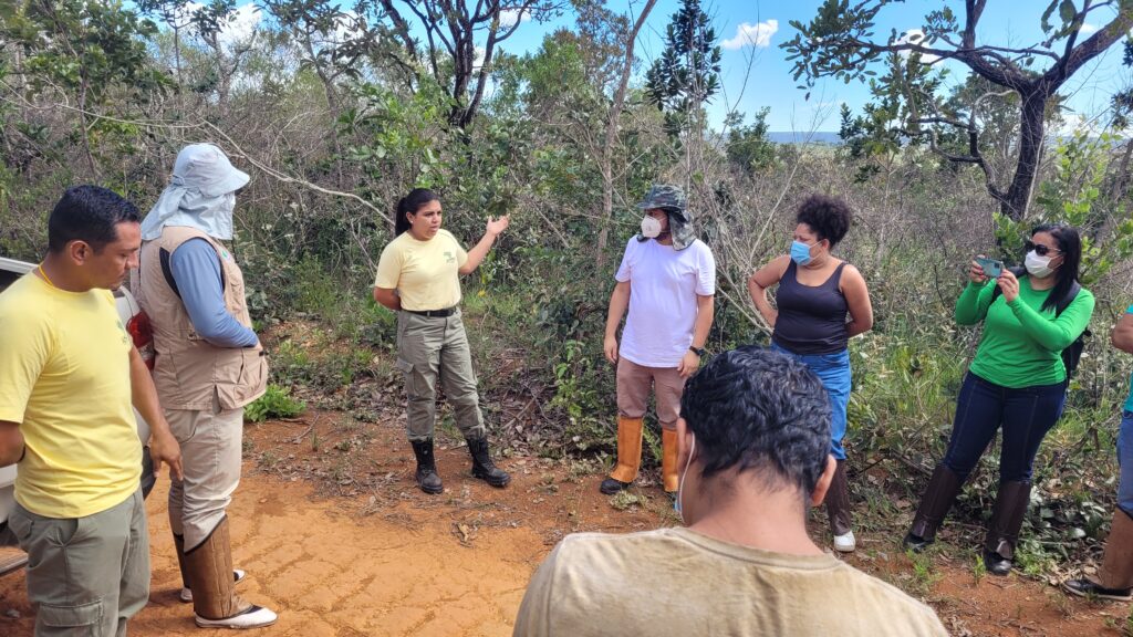
On March 28, 2022, firefighters from Indigenous communities across Brazil gathered in Brasília, the country’s capitol, for a week-long geography and cartography workshop. The workshop, a collaboration between the Coordination of Indigenous Organizations of the Brazilian Amazon (COIAB) and the Amazon River Basin (COICA), IPAM Amazônia, and Woodwell Climate Research Center, walked participants through the basics of using Global Information Systems technology to monitor and manage their own lands and forests.
Forests and native vegetation on Indigenous lands have been sustainably managed for millenia, and studies have found Indigenous stewardship of forests is an effective measure for preventing deforestation and degradation. Escaped fires can present a threat to forests, and many Indigenous communities have their own brigades that work on detecting and preventing runaway fires. In some places, prescribed burns are used as a tool for shaping and cultivating the land.
Participants attended from Indigenous lands located in a variety of Brazilian landscapes—from the Cerrado to the heart of the Amazon. Despite differences, participants found learning from other Indigenous communities extremely valuable.
“People came with a variety of skill sets,” said Woodwell Water Program Director Dr. Marcia Macedo. “What was most meaningful for participants was seeing other people like them, who do the same work and are also Indigenous people, already dominating material, knowing how to make the maps, and helping others. It gave them confidence that they could also figure it out.”
After a day of introduction to the core concepts of GIS and mapping, participants headed out to Brasília National Park to test their newfound skills. They visited burned areas from both an escaped fire and a prescribed burn, compared the two, marked GPS points, and took pictures. The data gathered on the field trip was used over the next few days to practice making maps.
“The goal was to not only teach the theory and help them understand the steps for making maps, but also mainly to develop the skills for them to be able to apply to their own lands on their own time,” said Woodwell postdoctoral researcher, Dr. Manoela Machado, who helped organize the event.
The workshop also fostered discussions about the complexity of management when fire can be both a threat and a tool. Because fire manifests differently in different biomes, well-managed fires look different for each community.
“On the final day, we had a discussion of values. Is fire good or bad? For whom—ants, forests, human health?” said Dr. Machado. “You can’t just criminalize fire if it’s a part of traditional knowledge and used as a tool for providing food, for example. So it’s a complex issue.”
Dr. Machado hopes the conversations will continue. She says the goal would be to host this workshop again to expand its reach, potentially beyond Brazil to include participants in other Amazonian countries.
Woodwell launches new project monitoring, combatting the effects of permafrost thaw
A $41 Million grant through The Audacious Project will fund Permafrost Pathways work
It’s a big idea—a pan-Arctic monitoring network for permafrost emissions—but big ideas are exactly what The Audacious Project was created to foster.
This April, Woodwell Climate Research Center was awarded 41.2 million dollars through Audacious to not only build such a network, filling gaps in our understanding of how much carbon is released into the atmosphere from thawing permafrost, but also to put research to work shaping policy and helping people.
The new project, called Permafrost Pathways, combines scientific prowess from Woodwell with policy, community engagement, and Indigenous knowledge from the Arctic Initiative at Harvard Kennedy School’s Belfer Center for Science and International Affairs, the Alaska Institute for Justice (AIJ), and the Alaska Native Science Commission.
Carbon emissions from permafrost thaw are one of the biggest areas of uncertainty in global climate calculations. Thawing permafrost is expected to release between 30 and 150 billion tons of carbon by 2100, the higher estimates on par with or even exceeding the United States’ cumulative emissions if allowed to continue at current rates. Yet permafrost is not accounted for in carbon budgets and international agreements. Permafrost Pathways will develop more complete data on permafrost carbon and deliver that research into the hands of those poised to decide how we deal with the warming Arctic.
Big problems require big solutions
Permafrost Pathways is led on the Woodwell side by Arctic Program Director Dr. Sue Natali and Associate Scientist Dr. Brendan Rogers, who have both been researching permafrost carbon for years. Dr. Natali found her way to the Arctic through a desire to work in a place significant to the global carbon story. The rapid changes she has witnessed in the past decade have underscored the Arctic as ground zero for climate change.
“I’ve seen dramatic changes from one year to the next in the places where I work, and Arctic residents have been observing these changes for decades,” Dr. Natali says. “You can measure something one year and then the ground there collapses the next. The physical changes across the landscape are really startling to see.”
Drs. Natali and Rogers have seen eroded hillslopes, research trips abandoned due to wildfire, community meetings with Arctic residents whose homes are sinking—every experience reinforced the fact that there was still much more to learn about how thawing permafrost feeds into climate change and is impacting Arctic communities.
The Audacious grant will allow Drs. Natali and Rogers to pull together the threads of their prior research into a project that starts to tackle the issue on a grander scale.
“When you’re focused on individual problems or hypotheses, you’re not able to really think big about something like monitoring across the Arctic,” says Dr. Rogers. “Opening up a funding source like this lets you think at a scale that matches the problems we face.”
The project is thinking really big, with the goal of installing 10 new eddy covariance towers—structures with instruments that measure carbon flux—in key areas where data is currently lacking. Pathways will also maintain existing key towers that would otherwise be decommissioned, and augment others to measure carbon fluxes year-round.
“There are a lot of existing towers that are either not running through the winter, or they’re not measuring methane, or they’re on hold for instrumentation upgrades or lack of funding,” Dr. Natali says. “We will get even more new data by maintaining old towers than constructing new ones.”
In parallel, Woodwell will work with a team at University of Alaska Fairbanks to develop a novel permafrost model that fully harnesses the data, accounting for important but currently neglected processes, and ultimately delivers more accurate projections of permafrost emissions to inform policy makers and Arctic communities.
‘It’s an awful decision’
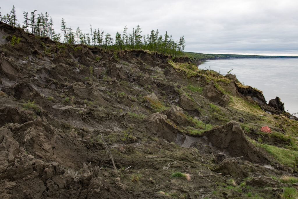
While the science team ramps up new data collection, AIJ will be breaking down the issue of adaptation. The Arctic is warming faster than anywhere else on Earth, and it is not waiting for exact measurements to make the consequences known.
The land upon which many Alaska Native communities are located is destabilizing in the face of usteq—a Yupik word for the catastrophic ground collapse that occurs when thawing permafrost, erosion, and flooding combine to pull the ground out from under them. In many places the formerly solid cornerstones of villages—houses, roads, airports, cemeteries— have had to be picked up and moved to more stable ground.
“It is an awful, awful decision that communities are being faced with because the land on which they’re living is becoming uninhabitable,” says Executive Director of AIJ, Dr. Robin Bronen.
On top of the trauma of watching their villages sink into the Earth, there is no clear path for Arctic communities deciding they must completely relocate.
“It’s become painfully clear that we in the United States have no institutional or governance structure to facilitate this type of movement of people,” says Dr. Bronen. There is no standardized way for people displaced by the climate crisis seeking resettlement to apply for funding and technical assistance for a community-wide relocation.
“If policy changes aren’t made nationally, then a lot of communities in the United States are going to be experiencing this incredible disconnect between making the decision that they are ready to leave, but having no resources to implement that decision,” says Dr. Bronen.
Permafrost Pathways will be working with Arctic residents to help them adapt to their rapidly shifting landscape. Through AIJ and the Alaska Native Science Commission, the project will connect with communities, collaborate to generate data they can use in their decision making and, if they make the choice to move, work with them to secure the resources needed for relocation.
Factoring Permafrost Thaw into our Global Future
Permafrost Pathways isn’t the first to tackle these issues but, Dr. Natali says, it does represent a unique combination of expertise that could push forward both carbon mitigation and climate adaptation policies.
Leader of the Arctic Initiative, professor, and Senior Advisor to Woodwell’s president, Dr. John Holdren understands the value of connections in making lasting change; he has been speaking to top policy makers in the U.S. and abroad for much of his career.
“All of us at the Belfer Center have been linking science and policy for a long time and communication is important to that,” says Dr. Holdren. “In my view, it’s going to remain important to have personal connections at high levels.”
Working through these connections, Permafrost Pathways will put the project’s science into the hands of policymakers to impress upon them the issue’s urgency.
“All the news coming out about permafrost carbon has been bad news,” says Dr. Holdren. “I think what we are going to find is that the high estimates are much more likely to be right than the low estimates. We’ve got to get that factored into the policy process.”
For Dr. Natali, the most important outcome of Permafrost Pathways is a future in which the threats presented by permafrost thaw are taken seriously by governments.
“I want to see permafrost thaw emissions accounted for,” says Dr. Natali. “I want to see the national and international community actually wrestle with the effects of permafrost thaw and to take action to respond to the climate hazards.”
Dr. Rogers says he hopes the collaborative nature of this already-big project will have even larger, rippling effects— paving the way for new partnerships and policy change.
“There’s the critical work that we will be doing, and then there are the new doors that a project of this scope opens,” says Dr. Rogers. “And we aren’t reaching our end goal without those open doors.”
The Audacious Project is an initiative of the non-profit TED that funds large-scale solutions to the world’s most challenging problems. Every year, the Project selects a cohort of big ideas to nurture with funding and resources.