Millions of acres of rangelands managed by the U. S. Bureau of Land Management are not meeting land health standards, according to a recent report from watchdog organization Public Employees for Environmental Responsibility. Range degradation is also happening on U.S. Forest Service and privately held lands. Healthy rangelands are vital to the economic and public health of the communities that depend on them, which includes ranchers, Indigenous nations, and recreationists. Failing rangelands undermine these groups, lead to loss of habitat, and result in landscape degradation, and they also minimize our ability to mitigate climate change through carbon sequestration. Taking policy action to ensure the longevity of rangelands has the potential to increase climate mitigation potential and improve the health of U.S. ecosystems.
What is healthy rangeland?
Covering more than 31 percent of the U.S., rangelands are any wilderness or rural open space grazed by domestic or wild herbivores, including grassland, shrubland, and pasture. Rangelands provide a wide array of ecosystem services, including food for livestock, habitat for wild species, and climate regulation through the uptake of carbon dioxide (CO2) by growing plants and the transfer of this sequestered carbon into the soil (as soil organic carbon). Globally, rangelands store 20 percent of the world’s soil organic carbon and U.S. rangelands may have the capacity to offset 2.5 – 3 percent of U.S. CO2 emissions from fossil fuels, but only if the rangelands are considered in “full health”.
Improving monitoring to foster healthy rangelands
The capacity for rangelands to sequester carbon is increasingly threatened by drought and overgrazing and there is an urgent need for improved land use planning to tackle these issues. However, the lack of an integrated monitoring system makes it difficult to know what changes to land management are needed on the individual ranch scale.
An important first step, then, to fostering healthy rangelands is establishing an open-access region-wide range monitoring platform that ranchers can use to verify and track changes in rangeland ecosystem condition and carbon storage across entire land units. Large-scale monitoring for these indicators will make it clearer where land is being effectively managed, and where it is not.
Dr. Jennifer Watts focuses on how climate change and human disturbance are affecting vegetation, soils, and the carbon cycle. She and her colleagues are currently working to develop a monitoring platform to provide stakeholders access to land health information.
“Having free, easy access to long-term information about lands will empower us to become fully aware of how our land use is impacting the health and future of rangeland ecosystems,” Dr. Watts explains. “This gives us the ability to invest in alternative management approaches that provide a more sustainable future for our lands while protecting our communities and ecosystems in the face of climate change.”
Building a system of rewards and incentives
Reward systems can then be established across different scales to incentivize land use that improves ecosystem services. Monitoring platforms can be used in conjunction with clear land management directives to ensure rangelands are managed in a way conducive to ecosystem health.
Overgrazing is one of the biggest drivers of rangeland carbon loss and land degradation. It not only undermines the carbon storage potential of rangelands but also compromises other ecosystem services and limits future grazing capacity for livestock and wildlife. Consequently, it is in the best interest of everyone–ranchers, conservationists, Indigenous groups, and recreationists–to ensure that grazing on rangelands is managed in a way that increases vegetation cover, diversity, and rooting depth, while minimizing bare ground. Grazing practices can be addressed through process-oriented approaches.
Practicing management intensive grazing could help limit overgrazing. This adaptive technique involves concentrating grazing animals in one place for a very short period of time and then moving them to a different location. This ensures that the ecosystem has a chance to recover and regrow following a concentrated period of grazing. Ranchers will need technical assistance to develop grazing and management plans. Given that this is a practice under the Environmental Qualities Incentive Program (EQIP) it is likely to receive a boost in funding from the 2022 Inflation Reduction Act. Building more programs, at the federal, state, and county level, that reward ranchers for shifting grazing techniques to those that support the sustainability of ecosystem services and provide equipment needed to support fencing and water distribution could be a way to incentivize more effective land management.
Manipulating grazing fees to more accurately represent the costs associated with maintaining the integrity of rangelands is another option for fostering healthier rangelands given the current low fees and stagnant pricing of grazing fees. Furthermore, revenue generated from increasing grazing fees on public lands could be used to support a monitoring system for all U.S. rangelands.
Most stakeholders agree that better rangeland monitoring, soil health, and payment for land improvements are important, but a big question is how to actually pay for these services across multiple levels of governance. Exploring how to leverage different options for funding, then, will be the necessary next step in supporting thriving rangeland ecosystems and reaping the potential climate benefits.
At age 12, Woodwell Assistant Scientist, Dr. Jennifer Watts was accustomed to black dirt—the rich, wet, crumbling, fertile stuff she dug through on her family’s hobby farm in Oregon. But after moving with her parents and siblings to a roughly 224-acre dairy farm in Minnesota, all she saw around her was light brown, dry earth.
“A lot of the farms around us were a mix of dairy farms and really intense cropping rotations of corn and soybean,” Dr. Watts says. “And I started to notice, where there was tillage, how depleted the soil looked.”
In the United States, farmland covers more than 895 million acres (an area larger than the size of India), and it has a proportionately massive footprint on the environment. Intensive agriculture pulls nutrients out of the soil and doesn’t always return them, converting natural grasslands into monocultures and releasing large amounts of stored carbon in the process.
But what Dr. Watts saw throughout a childhood spent tending to her family’s farm, was that changing the way agricultural land is managed can sometimes reverse those impacts. In converting their cropland to pasture, to support an organic, grass-based dairy farm, Dr. Watts and her family stumbled upon the principles of regenerative agriculture. A practice that can produce food in a way that works with the ecosystem, rather than against it, and has implications for climate mitigation as well.
“It became, for me, an unintentional transformative experiment that my family conducted on our farm,” Dr. Watts says. “By the time I graduated high school, our lands were so lush and green. It was a healthy, productive, diverse ecosystem again.”
Going rogue on the range
When Dr. Watts talks about her father’s idea to move to central Minnesota and start a dairy farm, she calls him a “rogue.” Originally from Alaska, he intended to work in fisheries, but had to change course after a cannery accident. Searching for something that would allow him to still spend his days outside, he settled on farming.
From the beginning, the Watts’ farming practices were considered unconventional in their rural Minnesota community. Firstly, they planted wild grasses and legumes like clover and alfalfa. Then, they left it alone. No tilling in the springtime alongside their neighbors; they simply let the plants establish themselves and moved the cattle frequently (with the help of a cow dog named Annie) to avoid overgrazing.
“After the first couple of years, I started noticing we had a lot more biological diversity in our fields, relative to our neighbors. We had a lot more bees buzzing, and butterflies, and we were popular with the deer and ducks,” Dr. Watts says. A few more years, and the soil started becoming dark and earthy-smelling again, like the soil she remembered from Oregon.
What was happening on their “rogue” dairy farm, was a gradual, partial reclamation of a lost grassland ecosystem— one that used to stretch across the midwest United States and was tended by native grazing species like bison or elk. Grazing plays a major role in cycling nutrients back into the soil, building up important elements like carbon and nitrogen. The near extinction of bison and the proliferation of monoculture cropping have broken this cycle—but cows have the potential to fill the gap left by ancient grazers, re-starting that process. Simple adjustments to management techniques, like lengthening time between grazing a pasture, can give the land time to recover.
Storing carbon in the soil
This also has implications for how we combat climate change—a term Dr. Watts wasn’t familiar with until later in high school, when family trips back to Alaska revealed the glaciers she loved to visit were shrinking.
“Seeing the glaciers was our favorite thing to do with my grandma, but they were beginning to disappear. And one year, suddenly, I noticed these informational panels along the walk exiting the National Park talking about this thing called climate change,” says Dr. Watts.
Dr. Watts was also seeing another pattern emerge on the farms in her midwest community. Water was becoming a little scarcer. Many of the farms around her family’s had begun investing in irrigation—something that was previously unnecessary, and remained so for the Watts’ farm. Their rich, black soil held onto the water for longer.
As she grew up and (with the help of a pre-Google web search over dial-up internet) charted a course for her career as an ecologist, Dr. Watts began to study the science underlying these patterns she was noticing, and connected them to climate change.
Growing plants draw carbon from the atmosphere. When plants die and decay, some of that carbon is released to the air to be drawn back down again by a new season of growth, while some is stored away as organic matter in the soil. Over centuries, this process forms a stable sink of carbon on the land. Regenerative grazing—the way the Watts family did it—stimulates more plant growth to keep this cycle turning, while overgrazing or removing grazers entirely can halt the process, allowing for erosion, less healthy root systems, and the degradation of the carbon sink. In the U.S., rangelands have historically contributed more to the depletion of soil carbon, but Dr. Watts’ research with Woodwell has demonstrated that, with proper management, rangelands and other agricultural lands have the potential to contribute positively to the climate equation again.
Seeing patterns from a new perspective
For the past two summers, Dr. Watts, alongside the Woodwell Rangelands team and collaborators, has driven across the western U.S. to collect biomass and soil samples and measure carbon flux from working ranches and federal grazing leases in Montana, Colorado, and Utah. These measurements will help calibrate a new satellite remote sensing-informed model that can track how much carbon is being stored on grazing lands. The model will be hosted on the Rangeland Carbon Management Tool(RCMT) platform—a new web application she and researchers at both Woodwell and Colorado State University are developing to give land managers access to carbon and other ecosystem data for their lands.
The idea is that, with a tool like this in hand, ranchers can account for carbon dioxide flowing into and out of the rangeland ecosystem, and track how this changes over time in response to land management adjustments. It will also show changes in correlating ecosystem metrics like plant diversity and productivity, as well as soil moisture—two things that are crucial to maintaining a healthy and economically viable range. With this information, Dr. Watts and colleagues hope to encourage a regional shift in ranch management strategies that protect and rebuild stores of soil carbon, while providing ranchers with essential co-benefits.
Dr. Watts has been working with Jim Howell, owner of sustainable land management company Grasslands LLC, to connect with individual ranchers and discuss how a tool like this could help their operations. Though ranchers can be a tradition-bound group, Dr. Watts says seeing data that confirms their anecdotal experiences of hotter winters, drier summers, longer droughts, and other climate-related changes has opened them up to making changes.
“There are so many times when we just see the ‘aha moment’ in the manager or the land owner’s face, because they’re suddenly able to see these patterns from a very different perspective,” says Dr. Watts. “Most people, we have strong memories, we know that something’s different, but to be able to show that through data and not only memories—it’s so powerful.”
Building climate solutions on the ground
In addition to ecosystem co-benefits, storing carbon on rangelands could have direct economic benefits for ranchers as well. The RCMT will provide baseline data that could be used to verify credits within a voluntary soil carbon market. Rangelands historically haven’t been included in carbon markets because of gaps in monitoring data that the RCMT will help fill. The data could also be useful for local or state governments setting up payments for ecosystem services schemes in their region that would provide money directly to ranchers in exchange for storing carbon on their lands.
Of course, cattle aren’t without their complications, and ranching practices are just one element of a global meat and dairy industry that contributes to 15 percent of global emissions. But Dr. Watts’ roots as a dairy farmer make her enthusiastic about the possibilities this solution holds to both mitigate emissions and keep an important American livelihood resilient as climate conditions change.
“It’s just one aspect in this really complicated global system,” says Dr. Watts. “But if we manage our ecosystems better, building more intact environments where we can, this can sequester more carbon while restoring ecosystem health and productivity. It’s not the solution, but it is a solution that can benefit our planet while supporting rural communities.”
What’s New?
The Cerrado is a tropical savanna located just southeast of the Amazon rainforest. This biome is a patchwork of forests, savannas, and grasslands, nearly as biodiversity rich as the Amazon yet suffering more due to lax environmental protections. Over 46% of its original land cover has already been cleared for crops or pastures. A recent study assessed the impacts of this conversion on the temperature and water cycling in the region.
The study found that clearing of natural ecosystems resulted in increased land surface temperatures and reduced evapotranspiration — water evaporated to the atmosphere both from soils and as a byproduct of plant growth. Across the biome, land use changes caused a 10% reduction in water being cycled into the atmosphere annually, and almost 1 degree C of warming. Where native savanna vegetation was cleared, temperatures increased by 1.9C and the water recycled to the atmosphere decreased by up to 27%. These changes don’t take into account the additional effects of atmospheric warming from greenhouse gas emissions.
The study also projects forward three potential future scenarios based on different levels of environmental protection. The worst-case scenario assumes an additional 64 million hectares of both legal and illegal deforestation, which would leave just 20% of native vegetation in the Cerrado by 2050. If illegal deforestation is prevented but legal deforestation still advances, an additional 28 million hectares of deforestation would continue to warm and dry out the region. Only in the most optimistic scenario, with enforced zero deforestation policies and restoration of over 5 million hectares of illegally cleared vegetation, would the impacts of past clearing begin to reverse.
“If we continue down this path of weakening environmental policies, we’re probably heading towards an uncontrolled increase in deforestation,” says Ariane Rodrigues, researcher at the University of Brasilia and lead author on the paper. “As a result, we could reach almost 1 C of temperature increase by 2050 from land use change alone. If we add the estimated temperature increase from global greenhouse gas emissions, we will have a critical situation for food production, biodiversity, water and wildfire risk, affecting areas located way beyond the biome’s limits.”
Understanding Land Use in the Cerrado
Incentives for large-scale commercial agriculture in the Cerrado date back to the 1970s. Despite its high biodiversity, only 11% of the Cerrado is protected and technological advancements provided favorable conditions for agriculture to expand rapidly.
The half of the biome that remains unconverted is considered prime agricultural land. The Cerrado alone is responsible for 12% of global soybean production and 10% of global beef exports. Growing demand for these agricultural products is pushing farmers and ranchers to expand into the Matopiba region in the Northeast Cerrado — one of the largest remaining areas of undisturbed native vegetation.
Hotspots of reduced evapotranspiration and increased temperatures can already be seen in areas of Matopiba with intensifying agricultural activity. This means that farms will rely even more heavily on irrigation to combat drought, a strategy made less viable by the warming and drying caused by agriculture itself.
“That is the driest portion of the Cerrado, where there’s the most climate risk already,” says paper co-author and Woodwell Water program director, Dr. Marcia Macedo. “You can see that in the data — it’s getting hotter, and there’s less evapotranspiration, so we are really intensifying conflicts in areas that are already on the edge.”
What this Means for Protecting the Cerrado
The results of the paper highlight the urgent need for a paradigm shift that values the additional services the Cerrado provides beyond just crop production. Not only does it house unique ecosystems, but it plays a pivotal role in modulating the climate of the region. In the best-case scenario evaluated by the paper, zero-deforestation and restoration policies could avoid extensive warming and drying and begin compensating for the past transformation of Cerrado landscapes. Continued conversion of natural vegetation will jeopardize both biodiversity and agricultural stability in the Cerrado, as crops struggle to be productive under hotter and drier conditions.
Already, conflicts over water usage and irrigation are occurring in western Bahía state. As the region warms and dries, competition for a scarce resource will become more common and large-scale agriculture will become much less viable.
“We’re making some risky decisions in terms of land use,” says Dr. Macedo, “We’re losing a lot for short term gains in crop production, often in areas that will struggle to sustain large-scale agriculture as climate changes.”
It’s a windy morning in May and the Valdez ranch in Delta County, Colorado is alive with the sounds of lowing cattle, chattering sparrows, and the whirrs and clanks of scientific equipment. This particular field is not being grazed at the moment, so Woodwell’s soil carbon team has free rein over the rows of alfalfa and sweetgrass.
In collaboration with Dr. Megan Machmuller at Colorado State University, Assistant scientist Dr. Jennifer Watts and senior scientist Dr. Jon Sanderman have brought their teams here to collect field observations that will help inform a comprehensive model of carbon storage on rangelands across the United States. Grazing lands have the potential to be a valuable carbon sink, provided the livestock on them are being sustainably managed, but the true magnitude of that value is not yet well understood. Developing a regional model of the way carbon moves through rangelands will deepen our understanding of the role they play as a natural climate solution.
Ensuring the model’s accuracy requires the team to collect an array of field data from different ranch types—from irrigated and planted pasture, to the natural vegetation of high mountain and desert grazing lands. Here’s how climate scientists study carbon in the field:
Carbon flux: What’s moving in and out of the atmosphere?
Soil carbon storage begins where plants interact with the air. As they grow, plants draw carbon out of the atmosphere through photosynthesis. When they decay, microbes in the soil digest plant matter and breathe carbon dioxide and methane back out. Measuring the difference between these two processes gives us “net ecosystem flux”—a measure of whether a patch of land is sequestering or emitting carbon overall.
Measuring carbon flux requires a specially made chamber. Dr. Watts and Seasonal Field Technician Jonas Noomah employed a plexiglass contraption that Noomah constructed himself. The chamber is placed over a patch of ground, connected by clear tubes to a machine that can analyze the volume of CO2 within the cube. A handheld fan dangles inside the box to keep the air circulating. The transparent plexiglass allows photosynthesis to continue unhindered. After a few minutes, the box is covered to block out the light and the analysis is run again to capture emissions without the photosynthesis component. The numbers can be compared to assess the rate and overall carbon sink or source status of flux within the ecosystem.
Plant productivity: What’s growing under-hoof?
While plants are growing, they lock away carbon as part of their leaves, stems, and roots, so another important metric in the carbon model is plant productivity—more productive plants with established root systems are more likely to store more carbon belowground.
Productivity can be estimated with satellite imagery, but needs to be validated with on-the-ground measurements. Postdoctoral researcher Dr. Yushu Xia and research assistant Haydée Hernández-Yañez walked transects of pasture to collect data on a variety of indicators that could influence aboveground (and belowground) biomass, including height of vegetation, soil moisture, and temperature. Then the scissors come out and all the plants in a plot are cut and put into a labeled paper bag to be weighed and analyzed later in a lab to determine the total mass of plant matter.
Rangelands managed for better carbon storage also come with a host of co-benefits, including higher levels of plant diversity. Different plants cycle carbon and other nutrients at different rates, so Hernández-Yañez sifts through the vegetation before it’s snipped, identifying and recording the species to provide more detail in productivity estimates.
Soil carbon: What’s locked deep in the ground?
Over time, carbon passes out of the cycle of growth and decay, becoming locked underground as soil organic carbon. Accessing and analyzing soil organic carbon requires coring deep into the earth and pulling out a stratified cylinder of dirt. Dr. Machmuller led the team’s soil coring effort along with Dr. Sanderman and research assistant Colleen Smith.
With a hydraulic soil coring machine attached to the back of a pickup truck, the team rambled through muddy pasture and over sharp bushes to collect 50 centimeter cores. When the terrain was too steep, they pulled out a handheld corer that had to be driven into the soil with a sledgehammer.
The soil cores are separated into three sections and crumbled up. Smith then uses a handheld scanner that employs the same technology used by astronomers to determine the chemical makeup of distant star systems to read the carbon content of each section. The scanner bounces light off the soil particles and the pattern of reflection gives clues to what molecules are present at different depths. Abundance of carbon is sometimes obvious to the naked eye in the cores, showing up as darker, wet sticky soil.
Putting data in the hands of land managers
Drs. Watts and Sanderman and their team are in the process of creating a rangeland carbon management tool that will make the soil carbon data model accessible directly to ranch managers. The website, developed by Dr. Xia, will generate data on carbon and plant productivity, for any geographic area down to the size of a single pasture. The hope is that the tool could be integrated into land managers long-term decision making, and show the results of adapting to more holistic, sustainable management practices over time.
“In the western US on our rangelands, just like in our croplands, we can change how we manage in a way that potentially could become a natural climate solution,” says Dr. Watts. “One where we’re bringing in more carbon than we’re emitting and we’re creating ecosystems that not only are beneficial for carbon sequestration, but also have more biodiversity, offer more habitat for wildlife, and more water conservation.”
Demonstrating the co-benefits of managing rangelands for carbon will also help expand conversations about whether ranching can be done sustainably, from the ground up.
“It allows for transfer of climate solutions into the hands of practitioners who may not otherwise think about climate change. It opens the conversation.” says Dr. Watts.
Ultimately, having that data could be useful for rangeland managers taking part in carbon credit markets, which could help them get paid for sustainable management.
“Rangelands haven’t been included in voluntary carbon credit markets like cropping systems have,” says Dr. Sanderman. “Their monitoring is a big problem because there’s so much land. How do you keep track of all that? That’s what our tool will be able to offer.”
Unequal heat
A visit to Worcester, Massachusetts in the heat of summer highlights the inequities of rising temperatures
It’s a hot, humid day in late August and we’re all already sweating as Arman Bajracharya begins to tell us about his project.
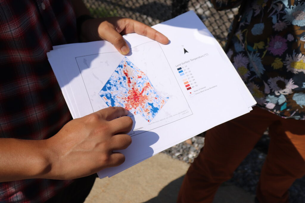
Bajracharya is a second year Ph.D. student in the geography department at Clark University in Worcester, MA, where we’re standing now. He pulls out a green and orange map of the city and points to our location on one of the orange blocks that signals industrial land use and impervious land cover.
We’re standing in the sparse shade of some trees ringing the edge of an old millpond, but we had to walk across a hot, cracked parking lot to access it. The neighborhood is called Webster Square. It is located in the southern reaches of Worcester, which was once a vibrant epicenter of the industrial revolution.
That industrial heritage is evident both on the maps Bajracharya shows us as well as in our surroundings. Truck beds and spare pvc piping and gravel piles rest at the edge of the water. It’s also scorching hot.
Temperature varies with land cover. In cities, the presence of impervious surfaces like asphalt, concrete, and metal trap heat, while natural surfaces—water or vegetation—can help buffer it. The distribution of these hotspots and heat buffers in Worcester, as in many cities, is not equal. Some neighborhoods endure much higher temperatures than others during the summer months.
Bajracharya’s research during the Summer of 2021 made possible by the Edna Bailey Sussman Fund employed remote sensing and census data to determine what features make a neighborhood more susceptible to extreme heat. He mapped temperature, land cover, and land use onto areas of greatest social vulnerability in Worcester, as well as two other post-industrial cities in Massachusetts, Haverhill and New Bedford. The results show that as climate change warms cities, the communities that have already experienced environmental inequities are likely to face more.
A gateway to the American dream
Worcester, Haverhill, and New Bedford are designated as gateway cities. These places, often important centers of the industrial revolution, have served as “gateways to the American dream,” offering job opportunities and housing for many who immigrated to the region.
Worcester began its industrial life as a mill town but soon grew into a manufacturing center for a variety of goods. It was also a crossroads of canal, and later, rail thoroughfares connecting the rest of Massachusetts with Providence and New York. Today, at the edge of the millpond in Webster Square, the remnants of an old rail bridge are still visible and active trains can be heard traveling the present day rail lines in the distance.
Industrial neighborhoods built to serve mills and factories often filled in with minority populations, and over time, wealthier families moved to quieter and more suburban areas of town. In the case of Haverhill, some communities also suffered the consequences of redlining, a discriminatory Federal Housing policy during the post-Depression era that limited financial services available to people, overwhelmingly African-American and people of color, deemed “hazardous to investment,” limiting social mobility and enforcing racial housing segregation. These factors often intensified the overlap between areas of high social vulnerability and industrial infrastructure.
“In the 1930s, these practices delineated which areas were defined to be good for financial services like loans,” Bajracharya says. “Which is why there is a historical divide between which areas are favorable and which areas are not. That can impact how we see the land being used today, especially where the greenspaces are.”
Mapping the heat
Bajracharya used available satellite data to show the relationship between land cover and social vulnerability. Examining the imagery, he created an index of relative heat in the city. Areas with high tree cover correlated with lower land surface temperatures. He then overlaid social vulnerability and environmental justice datasets that index communities in Massachusetts based on socioeconomic status, minority status, primary language, and other demographic information.
“Throughout many or most U.S. cities, neighborhoods facing greater environmental risks (such as from heat waves, urban flooding, and hazardous wastes) were historically settled by poorer families or racial and ethnic minorities,” Bajracharya says. “And there really is a lot of evidence for communities of color, or low-income communities, continuing to be disproportionately exposed to risk.”
According to Bajracharya, the analysis showed a startling overlap between the hottest areas of the city and the most vulnerable. Neighborhoods classified as Environmental Justice Communities tended to have a lower percentage of green vegetation (especially tree cover), with higher average temperatures. The most vulnerable areas are clustered in the core of the city.
The satellite maps only tell part of the story, however, which is why Bajracharya and his advisor Dr. Rinku Roy Chowdhury have brought us out onto the streets of Worcester. A few blocks away from the millpond, a grassy field rolls out behind a chain-link fence. In Bajacharya’s maps, this appears as a patch of vegetation interspersed among the developed land uses. The field sits under metal towers belonging to a nearby power station.
Often, Roy Chowdhury reminds us, the “green” and “blue” spaces that do exist in vulnerable areas may be inaccessible to residents, either cordoned off as private property or unsuitable for use due to safety concerns or an absence of trails or paths. The sign on the chain-link fence here warns of danger from high voltage.
This is where the distinction between land cover and land use becomes important. Land cover refers to what is currently on the land— whether that’s forest, grassland, or concrete. Land use data shows how humans are interacting with an area of land. For example, an area of grassy land cover could be used for conservation, residential or commercial purposes.
When natural land covers such as trees and water bodies are present but inaccessible, it limits potential social co-benefits that green and blue spaces can offer. Beyond regulating temperature, these spaces can reduce air pollution and provide recreational opportunities. Bajracharya and Dr. Roy Chowdhury emphasize the importance of field trips like this one, along with more in-depth work to ground truth satellite image analysis in local realities.
“There’s a really interesting mix of industrial and commercial uses interspersed with areas important for conservation and recreation, that could also potentially help in bringing down surface temperatures,” Dr. Roy Chowdhury says. “Tree cover and water are really helpful for buffering against the urban heat island, but so much more needs to be done to understand and steward such ‘ecosystem services,’ especially in underserved areas of cities.”
Building an Emerald City
With climate change accelerating, every patch of green and blue on the map will become indispensable in regulating city temperatures. To prevent a crisis of infrastructure failures and heat-related illnesses and even deaths from unfolding during brutal summers, cities like Worcester are going to have to get greener, faster—and do so in a way that benefits residents equitably.
Dr. Roy Chowdhury and Bajracharya are interested in investigating further to figure out the most promising pathways towards greener, more equitable cities. Questions still remain around finding the best proportion and distribution of land cover and implementation strategies that will improve environmental equity and encourage citizen participation. Woodwell’s Dr. Chris Neill has been collaborating with Dr. Roy Chowdhury and Clark University over the last decade to analyze land cover and ecological structure of urban vegetation in several US cities.
“Every tree makes a difference, but there are scale effects as well. What is the minimum threshold to make a difference? What’s the mix in different cities or neighborhoods? What do local residents value and want? These are really interesting and important questions to ask,” says Dr. Roy Chowdhury.
Research into the interactions between these green spaces and rising temperatures could help city planners make more conscious decisions about climate adaptation. Baracharya’s future projects may also examine flooding risk in cities, which adds another dimension to potential inequities in climate risk. Future research could also incorporate social interviews in different neighborhoods to understand residents’ concerns regarding their environment, climate change, and quality of life.
The last stop on our Worcester tour is Beaver Brook Park— an example of what’s possible when a city decides to reinvest in its natural spaces. The neighborhood surrounding the park was a primary destination for Black Americans moving north after the Civil War and has a history as a vibrant minority community. The titular brook had been paved over years ago, running in darkness under the city until 1990, when it was daylighted again to serve as a central feature of the park.
The area is now a green haven for recreation in the neighborhood and a stop on Worcester’s East-West trail, which Dr. Roy Chowdhury describes as “an emerald necklace” running through Worcester—one of the ways the city and numerous environmental stewardship organizations are working towards broader greenspace protections and access.
The feel of the air here contrasts sharply with where we started the day—a hint of the power urban greenspaces hold. Despite the heat warping off the street pavement, in the shade of old oak trees by the gurgling brook, it’s easy to stop sweating for a moment and just feel the breeze.