The last decade has shattered global temperature records, with all 10 of the planet’s warmest years occurring since 2015. Under the Paris Climate Agreement, countries across the world are working to limit global warming to 1.5 degrees Celsius by decreasing their heat-trapping greenhouse gas emissions. But researchers say more action is needed to protect us from the worst impacts of climate change.
“We’re beyond the point where emission cuts alone are going to keep us within a safe climate range. We need to remove carbon from the atmosphere,” Dr. Jonathan Sanderman, carbon program director and senior scientist at Woodwell Climate Research Center, says. “And there’s really two ways of doing that: tech-based solutions, like direct air capture or other engineering-based solutions, or we could try to reverse the last several 100 years of degrading nature and pull more carbon back into the biosphere.”
While both solutions are likely needed, Sanderman and others at Woodwell Climate are focused on using the power of natural environments, such as forests, wetlands, agricultural land, and rangelands, to reduce carbon in the atmosphere. These methods, called nature-based climate solutions, help combat climate change in three major ways: decreasing greenhouse gas emissions from deforestation, capturing and storing carbon from the atmosphere, and building ecosystems more resilient to climate hazards such as flooding and wildfires, according to the International Union for Conservation of Nature (IUCN).
Natural climate solutions could contribute more than 30% of the cost-effective climate solutions needed globally in the next few decades. They could also save countries hardest hit by climate change $393 billion in 2050 and reduce climate hazards by 26%.
Storing carbon on land
Sanderman researches one of Earth’s largest carbon pools: the soil. Plants release carbon they’ve absorbed from the atmosphere back into the ground when they die, which stores a total of about 2,500 gigatons of carbon globally.
“Soils hold four times as much as trees do — about three times as much as the atmosphere,” Sanderman says.
Good land management can stabilize the amount of carbon in soil, but soils across the world have degraded substantially due to cultivation and overgrazing around the turn of the century.
Storing carbon in the ground not only reduces the level of this greenhouse gas in the atmosphere, but carbon is the backbone of soil organic matter, which is a key regulator of soil health and crop yield consistency. It helps reduce erosion, keep soil structure in place and retain water. Carbon is often used as an indication of soil quality, with healthy soils usually containing about 2% organic carbon. Yet, precisely determining how much carbon is stored in soils worldwide — and which land management techniques lead to the most efficient carbon storage — is tricky.
Rangelands as a nature-based climate solution
Sanderman is working with Dr. Jennifer Watts, the Arctic program director and an associate scientist at Woodwell Climate, to understand how much carbon dioxide U.S. rangelands are helping capture. These lands have big potential for sinking carbon: Rangelands make up about 31% of land area across the U.S. and about 54% across the world. Using both field data and satellite data, Sanderman and Watts are creating models of overall rangeland health in the U.S. Using this information, they can then quantify how much carbon is gained or lost over time under different scenarios.
“We are hoping, with our integrated system, to be able to provide the ability to scan all landscapes to determine their carbon status, and then go back in time and look at the trajectories of change,” Watts explains. “And provide that information directly to the land managers so they can make really informed decisions on where they should invest conservation work. At the same time, it’s great for us, because as an output, we get to quantify how much carbon is being gained versus lost in certain places and what the climate benefits are.”
Capturing Methane
While carbon dioxide is one of the most abundant and long-lasting greenhouse gases, methane is far more efficient at trapping heat in the atmosphere. Per molecule, it’s about 80 times more harmful in the atmosphere than carbon dioxide, though it lasts an average of only a decade in the air, whereas carbon dioxide can persist for centuries. Nevertheless, reducing methane emissions by 45% by 2030 could help us reach our goal of limiting global warming to 1.5°C, per the United Nations.
Cutting anthropogenic methane emissions should be prioritized, but using nature-based solutions to increase uptake can also help bring down methane concentrations in the atmosphere. Although forests and soils play a smaller role in methane cycling, “When you start thinking about how much they can do over large areas, the numbers really get big,” Watts says. “And then it makes a huge difference.”
In northern forests across the U.S., Woodwell Climate researchers have set up methane monitoring systems, including specialized towers that measure the exchange of greenhouse gases, energy, and water between the ecosystem and the atmosphere. The team also analyzes soil samples from the forest to see exactly where methane-consuming and methane-producing microbes are thriving.
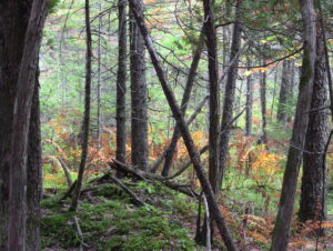
The team has discovered a unique feature of the Howland Research Forest in Maine: It is an overall methane sink — though exactly why remains unknown. But by understanding more about how and under which conditions these methane-consuming microbes live, forest managers can change their strategies to harness the creatures’ natural power to reduce the effects of climate change.
To combat the climate crisis, we must do “a lot of things simultaneously,” Watts says, including using good land management practices to capture and store greenhouse gases.
“Working with nature has a lot of advantages, because you’re optimizing the health of ecosystems, at the same time providing ecosystem services, not just for climate but also for local communities,” Watts says. “If we identify how to do this effectively, we’re really unleashing the power of something that’s already there, and then trying to work with it instead of against it.”
Woodwell Climate’s Government Relations team led the Center’s third annual D.C. fly-in this September, and you might say the third time was the charm.
“It was really impressive to see how we’ve built over the three years of doing the fly-in,” said Laura Uttley, Director of Government Relations. “The scale and scope of meetings, having five of 13 Congressional meetings be with Members themselves, and to have 17 Board members, senior leaders, and scientists participate—it’s just really exciting.”
Over the course of three days, the Woodwell Climate delegation tackled a range of near-term legislative priorities, such as the Natural Climate Solutions Research and Extension Act, standalone legislation that is currently being considered as part of Farm Bill negotiations and was adapted in the House version of the Farm Bill as “soil health research,” as well as longer-term policy development and relationship building.
Engagements spanned the full diversity of Woodwell Climate’s work. Meetings with leadership of the House Climate Solutions Caucus and Conservative Climate Caucus focused on the economic impacts of climate change and the need for expanded national climate services to make risk information available to all communities. A Permafrost Pathways delegation, including representatives of Alaska Native partner communities, shared a range of perspectives on rapid Arctic change with Alaska legislators and the Senate Indian Affairs Committee. One group talked with staff in the office of Rep. Paul Tonko (D-NY) of New York about carbon markets, and with Rep. Bill Keating (D-MA) and Sen. Ed Markey (D-MA) about Massachusetts-based research, including river monitoring and wetland restoration. Woodwell Climate also met with Democratic Whip Katherine Clark (D-MA) and Rep. Pete Aguilar (D-CA), Chair of the Democratic Caucus, to discuss opportunities to advance and protect climate policies, especially as leadership considers agendas for the next Congress.
Across all the sub-teams and meetings, Uttley says three big takeaways stood out:
1. Relationships matter
That Woodwell’s delegation secured thirteen Congressional meetings—five of them with Members themselves, including leadership of key committees and caucuses—is a testament to the Center’s credibility and the depth of relationships that the Government Relations team is building. A summer of high-profile Supreme Court decisions, the end of the fiscal year looming, and a tumultuous election cycle all contributed to a chaotic energy on the Hill in September, and legislators were only in session for three weeks between their summer recess and a break for election activities. Despite those pressures, Uttley says lawmakers and their staff were enthusiastic and engaged.
She attributes that to months (years, really) of relationship building grounded in a “here’s where we agree, and here’s how we can help” approach. An enormous amount of time and thought goes into crafting meeting agendas and materials that meet legislators where they are, address their needs and interests, and highlight common ground and opportunities for progress.
Consistency is also key, Uttley says. While individual Members come and go, and the political climate shifts, Woodwell Climate’s annual fly-in and growing year-round presence in Washington, D.C. are reminders that we are a reliable resource of information, and in it for the long haul.
2. Caucuses and committees are impact amplifiers
Meetings with individual legislators and/or their staff can be incredibly productive, but time is limited. Briefing an entire committee or meeting with leadership of a caucus group can be an effective way to get scientific expertise and policy priorities to many legislators at once. For example, part of the Woodwell delegation met with leadership of the bipartisan Climate Solutions Caucus (more than 60 members), staff for the House Sustainable Energy and Environment Coalition (100 Democratic members), and staff for the Conservative Climate Caucus, which has more than 80 Republican members, all interested in pragmatic climate solutions. These larger groups are also less susceptible to disruption through election cycles, which creates opportunities to work on policy agendas with a longer runway.
3. Accessible information makes a difference
Maps on the table, personal accounts of climate impacts, data tailored to a legislator’s district, and plain language science summaries were all on display during the fly-in, and Uttley says the Center’s commitment to making climate science relevant and accessible is a distinguishing feature that opens doors and builds relationships.
“To be able to find hooks and make climate science accessible for such a range of audiences on so many different topics is really impactful,” Uttley said.
Overall, Uttley said being in the room as scientists, community members, and policymakers —and seeing the energy they all came away with—left her with one overarching takeaway: Change is possible and “the Climate Science for Change motto is actually lived; it’s not just something we say.”
Leading ecologists call for strengthening nature-based climate solutions at the Federal level
Nature-based climate solutions (NbCS) have courted both enthusiastic support and considerable controversy (1–8). Defined as deliberate human actions that manipulate ecosystems to improve the planet’s greenhouse gas balance, NbCS provoke disagreement, in large part because their implementation has so far outpaced a science-based understanding of their long-term climate mitigation potential.
A new study published in the peer-reviewed journal Forests and Global Change presents the nation’s first assessment of carbon stored in larger trees and mature forests on 11 national forests from the West Coast states to the Appalachian Mountains. This study is a companion to prior work to define, inventory and assess the nation’s older forests published in a special feature on “natural forests for a safe climate” in the same journal. Both studies are in response to President Biden’s Executive Order to inventory mature and old-growth forests for conservation purposes and the global concern about the unprecedented decline of older trees.
Scientists have long demonstrated the importance of larger trees and older forests, but when a tree is considered large or a forest mature has not been clearly defined and is relative to many factors. This study develops an approach to resolve this issue by connecting forest stand age and tree size using information in existing databases. This paper also defines maturity by reference to age of peak carbon capture for forest types in different ecosystems. But the approach is readily applicable across forest types and can be used with other definitions of stand maturity.
Key findings include:
- The minimum age at which forests may be considered mature, according to peak carbon capture, ranged from 35 to 75 years among the regions and forest types studied.
- The carbon stored in all trees of the 11 forests totaled 561 million metric tons, of which 73% is in larger trees and 60% is in unprotected larger trees in mature stands.
- For 8 of the 11 forests that had carbon accumulation data, the annual rate was 4.7 million metric tons per year, of which about half is in unprotected larger trees in mature stands.
- Forest stands with the greatest carbon stored and highest annual carbon accumulation were mainly in the Pacific Northwest, and all but one of the national forests (Black Hills in South Dakota due to drought and insect related tree mortality) experienced an increase in above-ground carbon over recent years.
Researchers used thousands of forest plots obtained from the U.S. Forest Service “Forest Inventory and Analysis” (FIA) dataset to determine the amount of carbon absorbed from the atmosphere that accumulates and is stored in individual trees as they mature. As trees age, they absorb and store more carbon than smaller trees, making them uniquely important as nature-based climate solutions. Additionally, as the entire forest matures, it collectively accumulates massive amounts of carbon over centuries in vegetation and soils. The study identified the forest age at which carbon accumulation is greatest, and used that as the threshold for defining a “mature” forest. Scientists also determined the median diameter of trees at this threshold age and how much of the forest carbon of the larger trees in mature forests is unprotected from logging. The amount of carbon in unprotected larger trees in mature stands of the 11 forests studied, representing only 6% of federal forest land, is equivalent to one-quarter of annual emissions of carbon dioxide from fossil fuels in the U.S. This is consistent with prior work.
According to lead researcher, Dr. Richard Birdsey of Woodwell Climate Research Center, “our study determined when an individual tree in a forest can be considered mature and when the forest itself is at an optimal rate of carbon capture and storage for conservation purposes. It is directly responsive to the president’s executive order.”
The Biden administration has set bold emissions reduction targets of 50-52% of 2005 levels and recently announced a “roadmap for nature-based solutions” as part of this effort. However, the roadmap neglects to connect the importance of protecting older forests to the climate targets. Federal agencies are proceeding with an inventory of mature and old-growth forests in response to the executive order, but policies regarding their management have not yet been established. By protecting older forests and trees on federal lands from avoidable logging, the Biden administration can help close the gap on its emissions reduction goals. The methodology in this paper provides a readily implementable path for critical policy solutions.
According to Dr. Dominick DellaSala, Chief Scientist at Wild Heritage, “there seems to be a big disconnect between what the White House is wanting and how federal agencies are responding to the president’s forest and climate directives. While the Forest Service recently withdrew a controversial timber sale in older forests on the Willamette National Forest in Oregon (“Flat Country Project”) because it was inconsistent with the president’s directives, dozens of timber sales in older forests remain on the chopping block.”
Dr. Carolyn Ramírez, Staff Scientist with the Forests Project at the Natural Resources Defense Council, pointed to the findings as supporting the push by over 100 conservation groups – the Climate Forests Campaign – for a national rulemaking to protect mature forests and big trees from logging for their superior climate and biodiversity benefits: “This work reinforces how essential mature forests on federal lands are to securing our climate future. It’s now up to the agencies to protect these carbon storing champions from the chainsaw with formal safeguards. Our approach shows that logging protections grounded in a straightforward, age-based cutoff—such as 80 years, as many are calling for—would protect significant amounts of carbon, accommodate forest growth differences, and be readily usable in the field.”
“Talk to Jim. Jim knows everything.”
That’s what everyone told Woodwell Assistant Scientist, Dr. Jennifer Watts, when she started writing up a research plan to study soil carbon on U.S. rangelands. “And indeed, he does,” Dr. Watts says. “He knows everything about the region, about grazing management, species management, anything having to do with land management on these ranches.”
With his felt Stetson, dusty jeans, and perennial tan, ranch manager Jim Howell looks a bit like the kind of cowboy Hollywood might dream up. And in a way he is—despite looking at home on the range, Howell grew up in Southern California. But he spent his summers out in Colorado’s Cimarron mountains, working on his grandfather’s cattle ranch.
Those summers were Howell’s introduction to the idea that the way livestock are managed can change their impact on the land—a thread that would pull him through a college degree in animal production, towards a career “knowing everything” about holistic ranch management. He was first clued into this concept while walking the fence line separating his family’s property from a patch of public land being used to graze sheep.
“I noticed there were lots of very healthy, perennial, bunch grasses on the sheep side, while our side of the fence had degraded to mostly silver sagebrush, Kentucky bluegrass, and dandelions,” says Howell. “And I just didn’t understand why the differences were so stark.”
Howell’s cattle were stocked continuously on the land, low in number but able to graze year round, while the sheep grazing permit required rotation. There might be a great flock of sheep up there one day and nothing but grass for the remainder of the year. That difference, it turned out, dramatically altered the kinds of plants that could flourish on the land.
“I became aware then that the way that we’d been managing our cows in our country up there was leading to its slow, long-term, ecological degradation. And I didn’t know what to do about it,” says Howell.
The grazer makes the range
There have always been animals grazing the American West—before colonizers, even before native peoples. On the Great Plains there were bison; in the mountains and high altitude deserts of Southwestern Colorado, it was bighorn sheep and pronghorn antelope, as well as elk and mule deer. All three are rare sights now, with populations decimated by overhunting and habitat degradation.
Now, if you see any animal grazing on these ranges, it’ll probably be cattle.
Despite displacing native species, cows can still fill a natural niche in the rangeland ecosystem. Antelope, bison, sheep, and cows all belong to a group of animals called ruminants—animals that can digest grass. Many grasslands have co-evolved with ruminant species; their roaming feasts influence plant growth the same way pruning might affect the shape of a tree. Occasional shearing by a hungry cow stimulates new grass growth. It also creates a more competitive environment that supports a diverse array of plant species.
Grazing also plays a part in cycling nutrients and storing carbon in the soil. In a frequently dry climate like this one, digestion breaks down plant matter much faster than it would decay in the environment. Manure fertilizes new plant growth and returns carbon to the soil. Let this process continue unencumbered for a couple hundred thousand years, and you can build up a valuable carbon sink. And as long as the number of cattle isn’t rising, the oft-cited methane emissions from cow burps are minimal and cycled back down into the plants that grow up after grazing.
Since settlers arrived, however, the land has been put through centuries of abuse. Public lands were, for a long time, left open to unregulated grazing. Many rangelands have been over-stocked and grazed too frequently in order to make a profit and meet growing global beef demand. Land has been ecologically degraded, valuable topsoil was lost, and carbon stores declined as a result.
Let the cow do the work
It would be easy to blame cows for this. But really, they’re not behaving much differently than pronghorn or bison would. They eat what’s in front of them. And they eat the tastier plants first. Howell likens it to a salad bar.
“If you go into a salad bar and there’s some lettuce that has been sitting there for three months, and some of it that’s just been replaced that morning, you take the new stuff. So that’s exactly what the cow does,” Howell says. “If she’s not made to move anywhere new, she’s just going to keep coming back and grazing the regrowth of the good stuff as long as it’s there.”
Pretty soon, perennial grass species, important for their deep roots that help prevent erosion and store carbon and water longer, are grazed into nothing. All that’s left are the sagebrush, dandelions, and other less desirable plants that Howell noticed dotting his family ranch.
“So the whole thing is about how the cows are managed, it’s not the cow itself that is a problem,” says Howell.
But if bad management can degrade the land, then good management should be able to restore it. While studying animal science in college, Howell encountered the concepts of “holistic management”, a term that began to decode this relationship between management practices and the health of the land. Controversial at its introduction a half century ago, holistic ranching has been gaining traction, and Howell and his ranch management company, Grasslands LLC, have helped urge its uptake.
The core principle is to make management decisions that restore lands and keep cattle in balance with the rest of the ecosystem—helping them fill the niche of the ancient grazers. This comes with a host of co-benefits, including water retention and higher plant productivity, that actually end up improving economic profitability for ranches in the long run. Simple adjustments, like lengthening the time between grazing a pasture again and wintering cows on native ranges instead of hay, can turn cattle from an ecosystem destroyer to an ecosystem helper.
“The trick is to let the cows do all the hard work,” says Howell.
Carbon modeling: The rancher’s secret weapon
Dr. Watts and Woodwell Senior Scientist Dr. Jonathan Sanderman, along with Dr. Megan Machmuller of Colorado State University, are interested in quantifying those co-benefits. Especially carbon storage.
“In the western US on our rangelands, just like in our croplands, we can change how we manage in a way that potentially could become a natural climate solution,” says Dr. Watts. “One where we’re bringing in more carbon than we’re emitting and we’re creating ecosystems that not only are beneficial for carbon sequestration, but also have more biodiversity, offer more habitat for wildlife, and more water conservation.”
In order to prove that value however, scientists need a baseline understanding of how much carbon is currently stored across both traditionally-and holistically-managed rangelands. It’s hard to get an estimate for such a large area (roughly 30% of the U.S. is covered with rangelands), so they are using a remote sensing model, which they verify with strategic on-the-ground sampling.
Howell’s work also created the perfect conditions for the research team to study the long term carbon benefits of altered ranching practices, which is a tricky thing to test empirically. Ranchers must constantly adjust their management techniques to stay profitable.
“In a classical research setting, you try to control all the variables but one, but in real life that’s not what happens,” says Howell. “Nothing is controlled. Day to day, you have to adapt to constantly changing conditions.”
But the ranches Howell’s company works with make those day-to-day decisions based on the principles of holistic management, so tracking carbon on those ranches over time offers the opportunity to generate baseline data on how they differ from more traditionally managed ones.
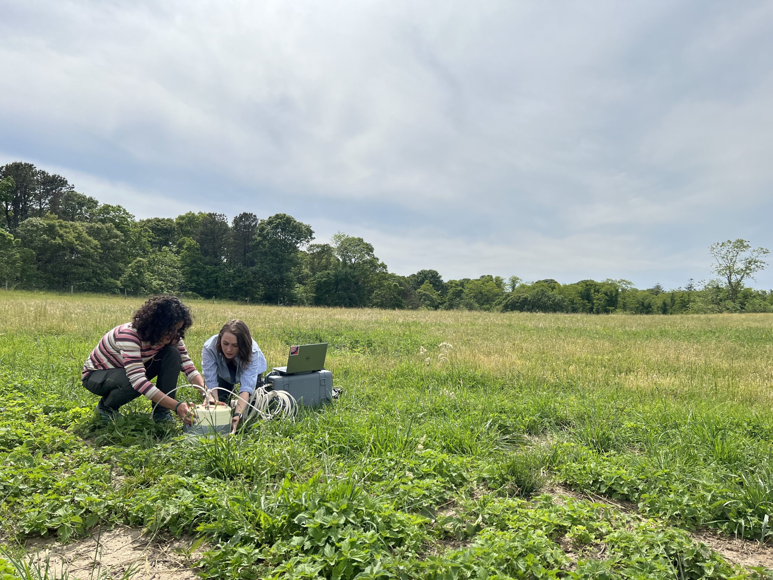
Howell also brought the expertise of a life spent on the range. He can identify just about any plant growing in the pasture, tell you which are native, which are invasive, and which used to be the preferred food of prehistoric ground sloths. His eye is trained to see diversity even in martian-esque deserts and read the history of the land in the structure of the soil. In May of 2022, Howell guided Drs. Sanderman, Watts, and Machmuller and their teams on a sample collection trip through Southwest Colorado and Utah. The researchers took soil cores, plant samples, moisture and temperature readings, and analyzed carbon fluxing in and out of the pasture.
The ultimate goal is to create a rangeland carbon management tool that will make the soil carbon data model accessible directly to ranch managers. Dr. Watts hopes having that data in hand will enable more ranchers to make management decisions with climate in mind. Dr. Sanderman also notes that it could be useful in eventually helping ranchers get paid for sustainable practices.
“Rangelands haven’t been included in voluntary carbon credit markets like cropping systems have,” says Dr. Sanderman. “Monitoring is a big problem because there’s so much land—How do you keep track of all that? That’s what our tool will be able to offer.”
Growing a resilient ranch
There are limits to what grazing can accomplish, though. The lands out west aren’t suitable for large-scale cropping, being too dry or too mountainous, which makes them perfect for cattle. But when the animals take up space on land that would otherwise be used to produce crops—or worse, penned into feedlots—their benefits are compromised. Howell also notes that some grazing lands are already as saturated with carbon as they can be. And there remains the fact that ranching will get more complicated as the climate changes.
At the Valdez ranch in Delta, Colorado, Dr. Sanderman and research assistant Colleen Smith unfold a collapsible table in a field of cracking mud, dotted with the brittle stick skeletons of dead grass. Nearby, Dr. Machmuller is assisting Howell in extracting a long metal cylinder from the ground. It was plunged into the soil by a hydraulic corer attached to a pickup truck that’s idling in the field. Howell and Dr. Machmuller lay it out horizontally on the table and slide out the soil core—a 50 centimeter long history of the land beneath their feet.
Howell breaks open a section of the core with his fingers, revealing clusters of white crystals. This is a pasture that has been abused; over-irrigation by previous owners brought salts to the surface. Now nothing will grow here and wind gusts threaten to blow away loose topsoil. It’s a sacrifice zone. The current owners are considering installing solar panels instead.
Water is a big issue for ranchers and it’s threatening to get bigger. The region is constantly dipping in and out of severe drought, and in a place that depends heavily on winter snows for its groundwater and rivers, a warmer, drier climate is a threat.
Agriculture will depend more on irrigation as the climate warms and precipitation patterns change. But this empty pasture is proof that it’s not always a viable solution, and will become less so as climate change advances.
It enforces the urgency of the work Howell and team are doing. The faster we can draw carbon out of the atmosphere, the more successful these ranches are likely to be in the long term. The better managed the ranch, the more resilient it will be in the face of tough conditions.
In the end, Dr. Watts says, the outcome rests in the hands of ranch managers—people like Howell.
“Land managers are the ones that ultimately are going to make or break this country.”
They keep us cool, we cut them down
Standing forests are our best natural climate solution. So why aren’t we treating them that way?
In terms of climate mitigation, forests are like green gold—working overtime to cool the planet, while also supporting a wealth of biodiversity. But we have not been saving them as one would a precious asset. Despite pledges to end deforestation, old growth forests are being cut down at alarming rates. And planting new trees is widely prioritized and incentivized over protecting existing forests. Across the board, standing forests are vastly undervalued. This has to change if we are to stand a chance of limiting warming to internationally agreed targets.
Forests are global air conditioners
According to a recent study from scientists at Woodwell and the University of Virginia, tropical forests alone are holding back approximately 1 degree Celsius of warming. About 75% of that cooling effect is due to carbon sequestration. Forests grow, trees lock away carbon in their trunks and roots and shunt it into the soil. The other 25% comes from the innate properties of forests that work to cool vast regions of the globe.
Through photosynthesis, plants release water vapor into the air in a process called evapotranspiration. The vapor contributes to cooling near the ground, as well as cloud formation higher in the atmosphere that reduces incoming solar radiation. The shape of the tree canopy also contributes. So-called canopy “roughness” disrupts air flow above the forest. The more uneven the canopy, the more turbulent the air, which disperses heat away from the surface. In the tropics, evapotranspiration and canopy roughness are high, which means that surface temperatures remain relatively low, with the heat dispersed throughout the deep atmosphere.
Forests also naturally produce molecules called biogenic volatile organic compounds (BVOC), which can either contribute to cooling by encouraging the formation of clouds, or to warming by creating ozone and methane. In the tropics, the net effect of these chemicals is cooling.
The cumulative result of these properties is that when forests are removed, the land around them begins to heat up even faster, which can increase the frequency of extreme heat and drought events. Without forests, some regions will become a lot less resilient to sudden shocks. And the release of carbon contributes to global warming which further exacerbates hot, dry conditions.
“Forests act like air conditioners,” says Woodwell Assistant Scientist, Dr. Ludmila Rattis, who studies the impacts of deforestation on agriculture in Brazil. “Deforesting in the face of climate change is like getting rid of your air conditioners before an upcoming heatwave.”
Not all forests are created equally
Protecting forests, and maintaining the cooling services they provide, is vital to limiting warming. But, with forests covering 30% of the Earth’s land, prioritizing protection is a massive task. And when it comes to carbon storage, not all forests are equally valuable. Older, healthier forests tend to have a more secure hold on their carbon.
“Mature forests have higher biodiversity and create their own microclimate,” says Woodwell Associate Scientist, Brendan Rogers. “They’re more resistant to drought and other types of disturbance. And because of that, they tend to be more stable in the face of environmental perturbations over time.”
New research from Woodwell and Griffith University has developed a method of identifying high-value forests using satellite imagery. Estimating the metric of “forest stability” through satellite data on the light reflected by vegetation and a water stress index of the tree canopy, researchers were able to determine gradients of stability within forest patches in the Amazon and boreal forests.
Using a gradient of forest stability allows for a better prioritization of forest protection strategies based on their carbon value.
“The first priority is to protect stable forests from further human disturbance,” says paper co-author Dr. Brendan Mackey. “The second priority is to identify forest areas where restoration efforts will be most cost effective.”
Guarding the forests that guard our future
But if the state of existing forests is any indication, forest protection continues to be deprioritized. Many wildfires are left to burn unless they threaten human settlements. Governments continue to incentivize deforestation for development or agricultural expansion. Indigenous and local communities are not compensated for their work stewarding their territories and keeping forests safe. And the warmer the planet gets, the more susceptible even protected forests become to drought, fire, and disease.
Research has shown that stewarding standing primary forests, and reviving degraded ones, represents the greatest opportunity for near-term carbon storage and removal. A study of global land-based carbon storage potential found that improved management of existing forests alone could store approximately 215 billion metric tons more than they currently do.
Protecting forests is cost effective, too. For example, in the United States, investing in fire fighting in Alaska’s boreal forests would require just $13 per ton of CO2 emissions avoided. That’s easily on par with other mitigation strategies like onshore wind or solar energy generation.
Effective strategies for protecting forests already exist, they’ve just been suffering from a lack of force—and often funding—behind their implementation. For example, forest carbon markets—where landowners and forest stewards are paid to protect standing forests that are otherwise vulnerable to deforestation—have the potential to keep forests safe while offsetting emissions from other sectors. But nascent carbon markets are inefficient, with weak standards for verifying the quality of credits being sold, and lacking the transparency needed to ensure credits are actually reducing overall emissions, rather than greenwashing carbon-intensive business practices.
Credits are also priced incorrectly for their relative climate value—the market currently values reforestation credits more highly, reducing incentive for landowners to conserve standing, old-growth forests when there is a better livelihood to be made in legally deforesting land for other uses. A truly effective carbon markets system would require large investments in science that can verify credit standards.
Forests are like our global carbon savings accounts—when we cut them down, we’re drawing out money and limiting our ability to collect interest and keep growing our funds. Successful mitigation can’t be accomplished without taking the full value of forests into account and strengthening policies to reflect that. If they aren’t, the planet will pay a far greater price for it as temperatures rise.
“We can’t afford to keep cutting forests. We need to reduce emissions now, and protecting forests is one of our best available solutions. Despite the obstacles, it’s worth the investment,” says Dr. Rogers.
Peterson Farm soil carbon ‘fieldwork’ for Opalite Media filming
June 2022
To confront that uncertainty and put nature-based climate solutions on a sound scientific footing, several dozen scientists and policy experts gathered in Washington D.C. in June of this year for a workshop sponsored by Indiana University, the U.S. Department of Energy, and the U.S. Carbon Cycle Science Program. The resulting white paper report reviews the current state of knowledge in this field, and describes the necessary research and technology investments to support effective mitigation policy.
According to the report’s lead author, Dr. Kim Novick from the Paul H. O’Neill School of Public and Environmental Affairs at Indiana University, “Nature-based climate solutions can play an important role in slowing the pace of climate change, but only if they are pursued alongside economy-wide decarbonization and guided by the best-available science.”
The white paper authors identify critical gaps in the science needed to support large-scale implementation of nature-based climate solutions and lay out a research agenda to fill these gaps. They also outline a set of principles that should guide future assessments of the effectiveness and viability of nature-based climate solutions. The result is a road map for producing information that will foster successful programs and policies—while avoiding energy wasted on those that do not.
Woodwell Senior Scientist, Dr. Jonathan Sanderman attended the gathering in June and contributed to the development of the paper.
“We’re at a unique moment in U.S. climate policy where the hard work of the research science community can be directly and immediately leveraged to help the U.S. fight climate change and become a world leader in implementing nature-based climate solutions.”
The report calls for a ~$1 billion (USD) coordinated investment in a national nature-based climate solution “Information Network” organized around coordinated ground-based experiments and monitoring that can inform rigorously benchmarked maps, model predictions, and protocol evaluations.
According to Dr. Benjamin Runkle, another report co-author and associate professor in the College of Engineering at the University of Arkansas: “Although the investment necessary to generate this information is not small, it is a fraction of the amount already allocated to implementation of nature-based solutions. Investing in sound science to predict, monitor, and verify the benefits of these strategies is fundamental to ensuring their success.”
In addition to their potential to stave off climate change, nature-based solutions also have a range of other benefits, including improving air and water quality, promoting biodiversity, and providing economic opportunities. Many can also help communities adapt to a changing climate and improve resilience of agricultural and food systems.
“There is broad-scale agreement that many nature-based climate solutions benefit people and the environment through co-benefits,” said Dr. Emily Oldfield, a report co-author and agricultural soil carbon scientist with the Environmental Defense Fund. “We should push to incentivize those practices using a wide range of policy tools, while acknowledging there is no one-size-fits-all approach to ecosystem-based climate solutions.”
Unequal heat
A visit to Worcester, Massachusetts in the heat of summer highlights the inequities of rising temperatures
It’s a hot, humid day in late August and we’re all already sweating as Arman Bajracharya begins to tell us about his project.
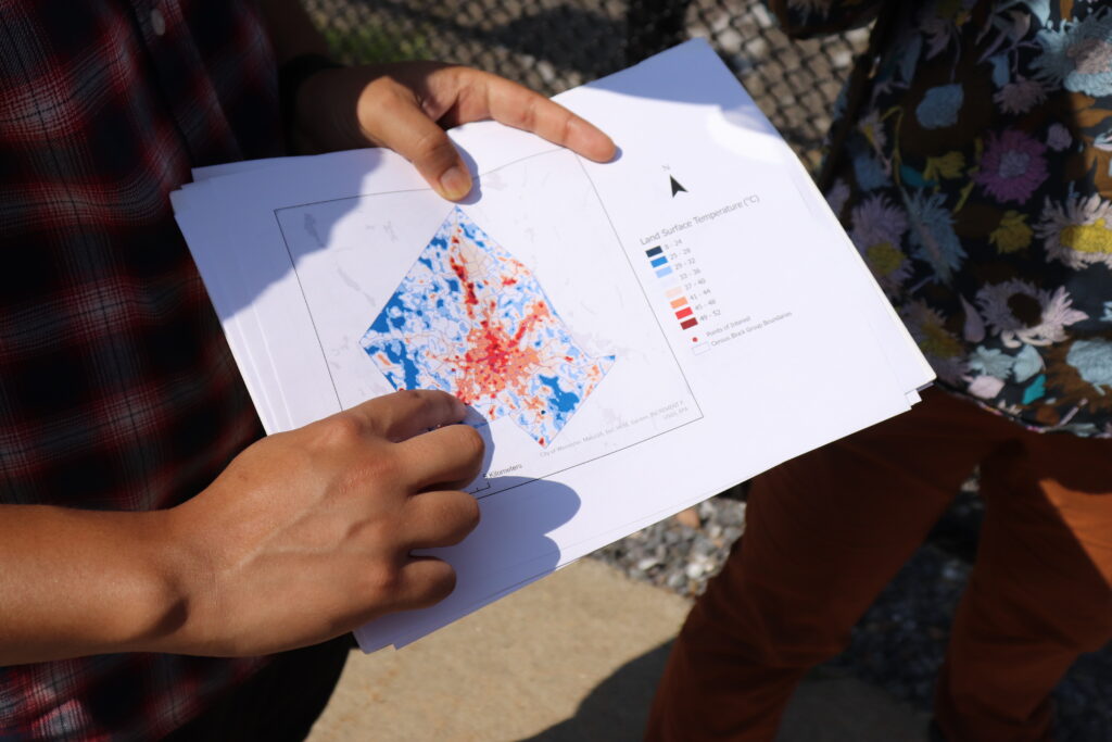
Bajracharya is a second year Ph.D. student in the geography department at Clark University in Worcester, MA, where we’re standing now. He pulls out a green and orange map of the city and points to our location on one of the orange blocks that signals industrial land use and impervious land cover.
We’re standing in the sparse shade of some trees ringing the edge of an old millpond, but we had to walk across a hot, cracked parking lot to access it. The neighborhood is called Webster Square. It is located in the southern reaches of Worcester, which was once a vibrant epicenter of the industrial revolution.
That industrial heritage is evident both on the maps Bajracharya shows us as well as in our surroundings. Truck beds and spare pvc piping and gravel piles rest at the edge of the water. It’s also scorching hot.
Temperature varies with land cover. In cities, the presence of impervious surfaces like asphalt, concrete, and metal trap heat, while natural surfaces—water or vegetation—can help buffer it. The distribution of these hotspots and heat buffers in Worcester, as in many cities, is not equal. Some neighborhoods endure much higher temperatures than others during the summer months.
Bajracharya’s research during the Summer of 2021 made possible by the Edna Bailey Sussman Fund employed remote sensing and census data to determine what features make a neighborhood more susceptible to extreme heat. He mapped temperature, land cover, and land use onto areas of greatest social vulnerability in Worcester, as well as two other post-industrial cities in Massachusetts, Haverhill and New Bedford. The results show that as climate change warms cities, the communities that have already experienced environmental inequities are likely to face more.
A gateway to the American dream
Worcester, Haverhill, and New Bedford are designated as gateway cities. These places, often important centers of the industrial revolution, have served as “gateways to the American dream,” offering job opportunities and housing for many who immigrated to the region.
Worcester began its industrial life as a mill town but soon grew into a manufacturing center for a variety of goods. It was also a crossroads of canal, and later, rail thoroughfares connecting the rest of Massachusetts with Providence and New York. Today, at the edge of the millpond in Webster Square, the remnants of an old rail bridge are still visible and active trains can be heard traveling the present day rail lines in the distance.
Industrial neighborhoods built to serve mills and factories often filled in with minority populations, and over time, wealthier families moved to quieter and more suburban areas of town. In the case of Haverhill, some communities also suffered the consequences of redlining, a discriminatory Federal Housing policy during the post-Depression era that limited financial services available to people, overwhelmingly African-American and people of color, deemed “hazardous to investment,” limiting social mobility and enforcing racial housing segregation. These factors often intensified the overlap between areas of high social vulnerability and industrial infrastructure.
“In the 1930s, these practices delineated which areas were defined to be good for financial services like loans,” Bajracharya says. “Which is why there is a historical divide between which areas are favorable and which areas are not. That can impact how we see the land being used today, especially where the greenspaces are.”
Mapping the heat
Bajracharya used available satellite data to show the relationship between land cover and social vulnerability. Examining the imagery, he created an index of relative heat in the city. Areas with high tree cover correlated with lower land surface temperatures. He then overlaid social vulnerability and environmental justice datasets that index communities in Massachusetts based on socioeconomic status, minority status, primary language, and other demographic information.
“Throughout many or most U.S. cities, neighborhoods facing greater environmental risks (such as from heat waves, urban flooding, and hazardous wastes) were historically settled by poorer families or racial and ethnic minorities,” Bajracharya says. “And there really is a lot of evidence for communities of color, or low-income communities, continuing to be disproportionately exposed to risk.”
According to Bajracharya, the analysis showed a startling overlap between the hottest areas of the city and the most vulnerable. Neighborhoods classified as Environmental Justice Communities tended to have a lower percentage of green vegetation (especially tree cover), with higher average temperatures. The most vulnerable areas are clustered in the core of the city.
The satellite maps only tell part of the story, however, which is why Bajracharya and his advisor Dr. Rinku Roy Chowdhury have brought us out onto the streets of Worcester. A few blocks away from the millpond, a grassy field rolls out behind a chain-link fence. In Bajacharya’s maps, this appears as a patch of vegetation interspersed among the developed land uses. The field sits under metal towers belonging to a nearby power station.
Often, Roy Chowdhury reminds us, the “green” and “blue” spaces that do exist in vulnerable areas may be inaccessible to residents, either cordoned off as private property or unsuitable for use due to safety concerns or an absence of trails or paths. The sign on the chain-link fence here warns of danger from high voltage.
This is where the distinction between land cover and land use becomes important. Land cover refers to what is currently on the land— whether that’s forest, grassland, or concrete. Land use data shows how humans are interacting with an area of land. For example, an area of grassy land cover could be used for conservation, residential or commercial purposes.
When natural land covers such as trees and water bodies are present but inaccessible, it limits potential social co-benefits that green and blue spaces can offer. Beyond regulating temperature, these spaces can reduce air pollution and provide recreational opportunities. Bajracharya and Dr. Roy Chowdhury emphasize the importance of field trips like this one, along with more in-depth work to ground truth satellite image analysis in local realities.
“There’s a really interesting mix of industrial and commercial uses interspersed with areas important for conservation and recreation, that could also potentially help in bringing down surface temperatures,” Dr. Roy Chowdhury says. “Tree cover and water are really helpful for buffering against the urban heat island, but so much more needs to be done to understand and steward such ‘ecosystem services,’ especially in underserved areas of cities.”
Building an Emerald City
With climate change accelerating, every patch of green and blue on the map will become indispensable in regulating city temperatures. To prevent a crisis of infrastructure failures and heat-related illnesses and even deaths from unfolding during brutal summers, cities like Worcester are going to have to get greener, faster—and do so in a way that benefits residents equitably.
Dr. Roy Chowdhury and Bajracharya are interested in investigating further to figure out the most promising pathways towards greener, more equitable cities. Questions still remain around finding the best proportion and distribution of land cover and implementation strategies that will improve environmental equity and encourage citizen participation. Woodwell’s Dr. Chris Neill has been collaborating with Dr. Roy Chowdhury and Clark University over the last decade to analyze land cover and ecological structure of urban vegetation in several US cities.
“Every tree makes a difference, but there are scale effects as well. What is the minimum threshold to make a difference? What’s the mix in different cities or neighborhoods? What do local residents value and want? These are really interesting and important questions to ask,” says Dr. Roy Chowdhury.
Research into the interactions between these green spaces and rising temperatures could help city planners make more conscious decisions about climate adaptation. Baracharya’s future projects may also examine flooding risk in cities, which adds another dimension to potential inequities in climate risk. Future research could also incorporate social interviews in different neighborhoods to understand residents’ concerns regarding their environment, climate change, and quality of life.
The last stop on our Worcester tour is Beaver Brook Park— an example of what’s possible when a city decides to reinvest in its natural spaces. The neighborhood surrounding the park was a primary destination for Black Americans moving north after the Civil War and has a history as a vibrant minority community. The titular brook had been paved over years ago, running in darkness under the city until 1990, when it was daylighted again to serve as a central feature of the park.
The area is now a green haven for recreation in the neighborhood and a stop on Worcester’s East-West trail, which Dr. Roy Chowdhury describes as “an emerald necklace” running through Worcester—one of the ways the city and numerous environmental stewardship organizations are working towards broader greenspace protections and access.
The feel of the air here contrasts sharply with where we started the day—a hint of the power urban greenspaces hold. Despite the heat warping off the street pavement, in the shade of old oak trees by the gurgling brook, it’s easy to stop sweating for a moment and just feel the breeze.
