

Unlocking the climate potential of global rangelands

Rangelands store a significant share of global soil carbon, and support billions of people’s lives and livelihoods. Yet they are nearly absent from climate policy. Woodwell is building the science to change that.

  • >50% of Earth’s ice-free land is rangeland
  • 20–30% of global soil organic carbon is stored in rangelands
  • 2M+ acres are currently under active monitoring

Why it matters

Rangelands are natural and managed grasslands, shrublands, deserts, and savanna woodlands that support grazing by livestock and wild herbivores. The Great Plains, the African savanna, and the Patagonian steppe are all rangeland landscapes, and the communities, wildlife, and food systems that depend on them are vast.

Rangelands provide food and livelihoods for over one billion people, support more than 70% of the world’s animal forage, and are home to some of the planet’s most biodiverse ecosystems—they contain two-thirds of all global biodiversity hotspots. They also store an estimated 20-30% of global soil organic carbon, making them a significant carbon reservoir on the planet.

Rangelands remain underrepresented in climate accounting, conservation finance, and land-use policy. Woodwell is working to close the gap by making rangelands’ role as climate-critical ecosystems visible, measureable, and actionable. Our research focuses on rangelands that encompass both wild (natural) and managed (pastures) ecosystems. Pastures are areas of managed perennial plants used for grazing and/or hay production (e.g. the cattle pastures scattered across the intermountain US).

Woodwell is driving actionable change in rangelands by bringing together carbon cycle science, remote sensing, ecosystem modeling, field verification and climate policy recommendations to help decision-makers understand the true climate impact of rangelands and act on that information.
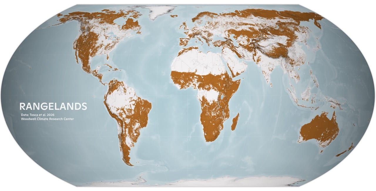
Global map with rangelands highlighted

What we’re building

Climate Impact Accounting

Rangelands are large carbon reservoirs, and they must be measured so that they can be protected. We have developed an open-source ecosystem model (RangeSTAR) that estimates carbon fluxes, impacts of water stress, and soil carbon storage across US (and soon, global) rangelands. The model is peer-reviewed and publicly available.

Robust Rangeland MMRV

Verifying the carbon measurements is critical. We are working with producers, land managers, and carbon markets to develop carbon-focused measurement, monitoring, reporting, and verification (MMRV) to track outcomes of conservation practices in grazing systems. Our approach integrates ecosystem principles and encompasses land-atmosphere carbon exchange in addition to carbon stocks.

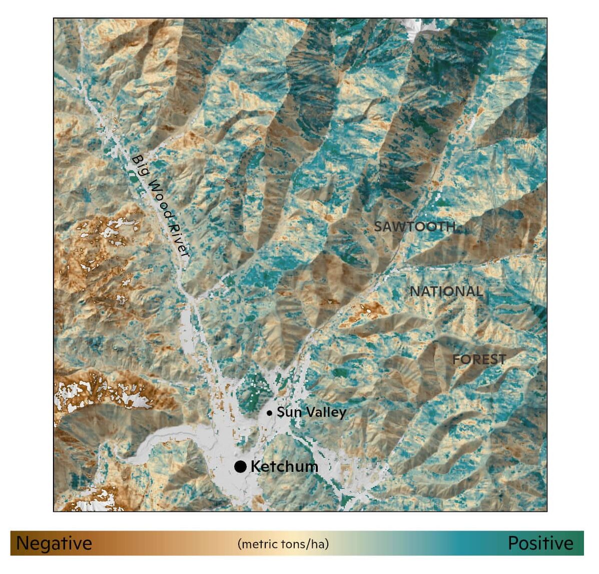
a map shows total soil organic carbon in the landscape. in general, the area south of the big wood river has negative soc, while the area north of the river has positive soc

Interactive tool to guide Rangeland Conservation Policies and Investing

Robust science only creates change if it reaches the right people. We work with US and global organizations to provide the best science and data available to guide climate and conservation policies and investment decision making, going beyond just carbon fluxes to inform stakeholders of management impacts on other land characteristics like biodiversity, soil health, and water stress.

Digital Soil Mapping

Most land managers don’t know how much carbon is stored in their soil, even though it impacts every decision they make. Using machine learning and targeted field sampling, our Woodwell rangelands team maps soil organic carbon stock at the ranch scale, and at high resolution. The approach lets land managers “see” what’s stored beneath their feet without costly blanket surveys.

All of these efforts come together in our rangeland carbon model, RangeSTAR. Learn more about RangeSTAR.


Commitments driving this work

Make grazing lands visible in climate accounting and global frameworks.

We are producing science-informed assessments of grazing land climate and ecosystem status at U.S. and global scales, including plant productivity, net ecosystem carbon exchange, soil organic carbon, methane, nitrous oxide, fire emissions, and albedo where relevant.

Build robust, scalable monitoring systems for grazing lands.

We are advancing transparent and scientifically credible MMRV systems, including tools such as RangeSTAR, SMAP-based assessments, field calibration, and remote sensing, so producers, land managers, investors, markets, and governments can track climate and conservation outcomes.

Integrate climate and ecosystem co-benefits into conservation and land management.

We are supporting data-informed guidance for conservation practices, adaptive grazing approaches, restoration, cropland-to-grassland conversion, and protection of intact open lands, helping shift decisions from practice-based assumptions to measured performance.

Align finance and market incentives with verified climate performance.

We are working with partners to improve how grazing land climate benefits are valued, verified, and used to guide conservation finance, producer incentives, policy levers, and market-based investment.


For more information, please contact Dr. Jennifer Watts, Associate Scientist & Rangeland Program Lead at jwatts@woodwellclimate.org.